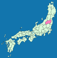
Iwashiro Province
Encyclopedia

Fukushima Prefecture
is a prefecture of Japan located in the Tōhoku region on the island of Honshu. The capital is the city of Fukushima.-History:Until the Meiji Restoration, the area of Fukushima prefecture was known as Mutsu Province....
. It was sometimes called .
The province occupies the western half of the central part of Fukushima Prefecture; the eastern half is Iwaki Province
Iwaki Province (1868)
thumb|Map of the former Japanese provinces with Iwaki highlighted was an old province in the area that is today Fukushima Prefecture. It was sometimes called .-History :This iteration of Iwaki Province was established in Meiji Era...
. More precisely, Date
Date District, Fukushima
is a district located in Fukushima, Japan.As of 2008, the district has an estimated population of 39,633 and a density of 190 persons per km². The total area is 208.53 km².-Towns and villages:*Kawamata*Kōri*Kunimi-Mergers:...
and Adachi
Adachi District, Fukushima
is a district located in Fukushima, Japan. As of January 2007, the district has a population of 8,577 and an area of 79.46 km², for a population density of 107.9 per km².- History :...
Districts in the north belong to Iwashiro and Higashishirakawa
Higashishirakawa District, Fukushima
is a district located in Fukushima, Japan.As of 2003, the district has an estimated population of 38,087 and a density of 61.34 persons per km². The total area is 620.94 km².-Towns and villages:*Hanawa*Samegawa*Tanagura*Yamatsuri...
and Nishishirakawa
Nishishirakawa District, Fukushima
is a district located in Fukushima, Japan.As of 2003, the district has an estimated population of 68,450 and a density of 138.39 persons per km². The total area is 494.63 km².-Towns and villages:*Izumizaki*Nakajima*Nishigō*Yabuki-Merger:...
Districts in the south belong to Iwaki. The border between the two provinces is the Abukuma River
Abukuma River
The , with a length of 234 km, is the second longest river in the Tōhoku region of Japan and the 6th longest river in Japan. It runs through Fukushima Prefecture and Miyagi Prefecture, rising from springs in the peaks of the Nasu Mountains, collecting water from tributaries leaving the Ōu Mountains...
.
Timeline
On December 7, 1868, the province was formed out from Mutsu ProvinceMutsu Province
was an old province of Japan in the area of Fukushima, Miyagi, Iwate and Aomori prefecture and the municipalities of Kazuno and Kosaka in Akita Prefecture...
. As of 1872 , the population was 427,933.
Districts
- Aizu (会津郡)
- Adachi (安達郡)
- Asaka (安積郡)
- Iwase (岩瀬郡)
- Ōnuma (大沼郡)
- Kawanuma (河沼郡)
- Shinobu (信夫郡)
- Date (伊達郡)
- Yama (耶麻郡)

