Jamalabad
Encyclopedia
.jpg)


Mangalore
Mangalore is the chief port city of the Indian state of Karnataka. It is located about west of the state capital, Bangalore. Mangalore lies between the Arabian Sea and the Western Ghat mountain ranges, and is the administrative headquarters of the Dakshina Kannada district in south western...
) is 1788 ft above sea level and was formerly called Narasimha Ghada, which refers to the granite hill on which the fort is built. It is also referred locally as 'Jamalagadda' or 'Gadaikallu'.
The fort was built by Tippu Sultan in 1794 and named after his mother, Jamalabee. The fort is said to have been built over the ruins of an older structure.
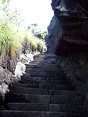
The fort is inaccessible other than via a narrow path, with nearly 1876 steps to the fort that are cut out of the granite hill and lead all the way to the top through the fort to the summit. This would mean that a small but well armed group could indefinitely block a much larger force from entering the fort.
Inside the citadel there is only one tank to store water. There are the remains of a single cannon on the hillock. Nothing much of the fort remains but hints of the fort wall with parapets. In addition, there is also an unmanned microwave repeater station on top of the hill.
The fort was captured by the British in 1799 during the 4th Mysore war. Legend has it that those out of favour with Tipu were hurled down the edge to their death. (Such 'Tipu drop's are a feature in most hill-top forts built by Tipu.)
These days, Jamalabad is a trekking destination, with the climb up to the fort being classified as 'medium difficulty level' and the top of the structure offering good views of the surrounding landscape and the Kudremukh
Kudremukh
Kudremukh also spelled Kuduremukha is a mountain range in Chikkamagaluru district, in Karnataka, India. It is also the name of a small hill station town situated near the mountain, about 48 kilometers from Karkala and about 20 kilometers from Kalasa...
range.
At the base of the hill is a forest check post where visitors have to pay a nominal entry fee. Visitors should carry plenty of water since there is no potable fresh water available on top. The nearest town with any communication and medical facilities is Belthangady. (Beltangadi)
Officially entry to the fort is restricted to between 6am to 6pm . Overnight stay at the fort is prohibited. The hillock has only one room on top of it. It is not considered a tourist attraction but is a good destination for enthusiastic trekkers.

