
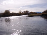
Jefferson River
Encyclopedia
The Jefferson River is a tributary
of the Missouri River
, approximately 83 miles (134 km) long, in the U.S. state
of Montana
. The Jefferson River and the Madison River
form the official beginning of the Missouri at Missouri Headwaters State Park
near Three Forks
. It is joined 0.6 mile (0.965604 km) downstream (northeast) by the Gallatin
.
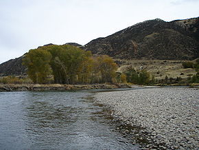
From broad valleys to a narrow canyon, the Jefferson River passes through a region of significant geological diversity, with some of the oldest and youngest rocks of North America and a diversity of igneous, metamorphic, and sedimentary formations.
The region was only intermittently inhabited by Native Americans until relatively recent times, and no single tribe had exclusive use of the Jefferson River when the Lewis and Clark Expedition first ascended the river in 1805. Today, the Jefferson River retains much of its scenic beauty and wildlife diversity from the days of Lewis and Clark, yet is threatened by water use issues and encroaching development. The Jefferson is a segment of the Lewis and Clark National Historic Trail
, administered by the National Park Service
.
 From the Rocky Mountains
of southwestern Montana
, three small rivers converge to form the headwaters of the Jefferson River. The longest begins at Brower's Spring
, 9,030 feet (2,750 m) above sea level, on the northern flank of the Centennial Mountains
. The site is marked by pile of rocks. The water flows west then north as Hell Roaring Creek before merging with Rock Creek and flowing west through Upper and Lower Red Rock Lakes. Here it becomes the Red Rock River
, flowing west through Lima Reservoir and then northwest into Clark Canyon Reservoir near Dillon
. Below the dam, the river is known as the Beaverhead River
. It is joined by the Ruby River
above the town of Twin Bridges and converges with the Big Hole River
to form the Jefferson about two miles downstream from town.
The Jefferson River flows north through the Jefferson Valley towards Whitehall
and then east, where it is joined by the Boulder River
before passing through the narrow Jefferson River canyon near Lewis and Clark Caverns State Park. After the canyon, the river passes into a broad valley again near Willow Creek
. The Jefferson converges with the Madison River
at Missouri Headwaters State Park
near Three Forks to form the Missouri River, joined a short distance downstream by the Gallatin River
.
Eon, 2.7 billion years ago. Found primarily in the Tobacco Root
and Ruby
ranges, these ancient rocks are metamorphic, having been highly compressed and nearly re-melted by geologic forces over eons of time. Frequently found along the Jefferson River, these rocks include layered feldspars, gneiss, glassy quartz, heavy dark amphibolite, and sometimes marble.
About a billion years ago, the Willow Creek Fault, north of the Jefferson River canyon, dropped down deeply and filled with seawater, stretching north to Alberta and British Columbia. Eventually, the sea receded and erosion wore away intervening geologic history until about 530 million years ago, during the Cambrian Period of the Paleozoic Era.
A new sea encroached on the land, depositing sedimentary layers of limestone
, dolomite
, shale
, and sandstone
over several hundred million years. Limestone is generally made of calcium from marine animals that have been compacted and cemented together. Dolomite is similar but has more magnesium. Shale is formed from fine-grained mud, silts, and clays that have been compacted and cemented together. The sandstone is made up of quartz and feldspar.
By the Mississippian Period, 340 million years ago, much of western North America was covered with a warm, shallow sea, much like the Gulf Coast of Florida today. Small marine fossils can be found in the Madison Group limestone that makes up the steep, narrow section of the Jefferson River canyon today.
Gentle uplift eventually raised the region above sea level again. Rainwater percolated down through cracks in the limestone, dissolving rock and creating caves such as those found at Lewis and Clark Caverns State Park.
Local mountains, such as the Tobacco Roots were formed from the Boulder Batholith
. The batholith is composed of at least seven, and possibly as many as fourteen, discrete igneous rock masses called plutons, which formed beneath the Earth’s surface during a period of magma
intrusion
about 73 to 78 million years ago during the Late Cretaceous
. The rising buoyant plutons resulted from subduction
along what was then the west coast of North America. Regional uplift brought the deep-seated granite
to the surface, where erosion exposed the rocks and the mineral veins they contained. The granite generally consists of quartz, hornblende, and feldspars. Gold, silver, and other semi precious minerals are also associated with batholiths.
The ancient metamorphic and more recent sedimentary layers above the batholiths eroded away as the magma pushed up through the crust. Thus, the granite batholiths are typically found at the center of local mountain ranges, while the much older metamorphic gneiss is usually found lower in the mountains, and limestone layers are mostly found in the foothills nearest the Jefferson River.
The Rocky Mountains began a new and continuing phase of crustal stress 5 to 10 million years ago as tectonic forces began to pull the region apart. Blocks of earth dropped down to form valleys, and the Jefferson River eroded a channel through rock to form the Jefferson River canyon.
hunted the now-extinct mammoths and bison with Clovis points
. Clovis points dated 12,000 to 13,000 years old have been found along the Missouri River near Townsend
, Montana, about forty-five miles beyond the Jefferson. Paleo-Indians seldom entered the Rockies, where glaciation persisted.
Upstream from the Jefferson, at Barton Gulch
, a tributary of the Ruby
-Jefferson River system, archaeologists excavated an extensive complex of Paleo-Indian cooking pits and earth ovens dated to 9400 RCYBP (radio carbon years before the present).
Between 6,000 and 7,000 years ago, climate change brought dramatically drier conditions to the Northern Rockies. It is thought that far fewer animals survived in the region and the native peoples likely migrated elsewhere. Montana was apparently only intermittently inhabited after that until relatively recent times.
In the 1500s, the Kootenai came into Montana from the north. The Salish and Pend d'Oreille migrated in from the north and northwest, venturing south to the Jefferson River/Missouri Headwaters and eastward. Major population shifts started in the early 1600s, bringing several new tribes into Montana. With horses of Spanish origin, the Shoshone migrated into Montana from the Great Basin
and hunted buffalo, becoming the dominant tribe in the area. However, the arrival and expansion of European settlers on the east coast pushed Native Americans west, in a domino effect that extended all the way into Montana. The Crow
migrated into Montana from the east in the 1600s, followed by the Blackfeet
, Gros Ventre, and Assiniboine in the 1700s. With the acquisition of guns and horses, the Blackfeet became the dominant tribe on the plains in the 1700s. The Shoshone were largely pushed back over the continental divide into Idaho, but still ventured into Montana hunting and foraging. By 1800, the Missouri headwaters and much of southwest Montana was a crossroads frequented by the Lemhi Shoshone
, Bannock, Nez Perce, Flathead
, Crow
, Sioux
, and Piegan Blackfeet.
Sacagawea
, of the Lemhi Shoshone, was captured by the Hidatsa on the lower Jefferson River in 1800, when she was about twelve years old. She was later married to Toussaint Charbonneau
and both of them joined the Lewis and Clark Expedition
when Lewis and Clark wintered with the Hidatsa in North Dakota in 1804-05.
 The United States acquired the Missouri River watershed through the Louisiana Purchase
of 1803, and President Thomas Jefferson
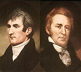
sent Meriwether Lewis
and William Clark with a company of men to explore up the Missouri in the hopes of finding a navigable water route to the Pacific, with a low portage connecting one watershed with the other. The Expedition departed from Saint Louis, Missouri in the spring of 1804, ascended the Missouri River that summer, then wintered over with the Hidatsa Indians in North Dakota, where they met Toussaint Charbonneau and his Shoshone wife Sacagawea. Lewis and Clark hired Charbonneau to join the expedition, in part because Sacagawea's people were native to the Missouri headwaters. The Lewis and Clark Expedition arrived at the Missouri Headwaters on 27 July 1805.
Of the three streams that make up the headwaters of the Missouri, the eastern fork is the smallest, while the larger middle and western forks are of relatively equal size. Therefore, Lewis and Clark concluded that it would be inappropriate for any fork to retain the name "Missouri." Instead, they named the western fork the Jefferson, the middle fork as the Madison, and the eastern fork as the Gallatin, as Meriwether Lewis
noted in his journal on July 28th, 1805:
The expedition rested a couple days at the Missouri headwaters, then began to ascend the Jefferson River, using ropes to pull the dugout canoes upstream against the current. Along the way they hunted deer, elk, bighorn sheep, and encountered grizzly bears. Describing the upper Jefferson River, Lewis recorded on August 2, 1805:
Arriving at a major confluence, Lewis and Clark named the western fork the Wisdom River, the eastern fork the Philanthropy River and retained the middle fork as a continuation of the Jefferson River. However, none of these names were retained. These rivers are known today as the Big Hole
, the Ruby
, and the Beaverhead
.
The Jefferson River is a segment of the Lewis and Clark National Historic Trail
, established by Congress in 1978 and administered by the National Park Service
.
The upper Jefferson is a much-braided, meandering river and floodplain system that supports productive farm fields, extensive cottonwood groves, rich meadows, and abundant wildlife. The river creates diverse habitats as it naturally shifts back and forth across the Jefferson Valley, forming oxbows and swamps of various depth and age. Shifting channels and natural flooding facilitates the germination of cottonwood seedlings. Individual cottonwood groves are often germinated from a single flood event and tend to be of uniform age. The upper Jefferson extends from the confluence of the Big Hole
and the Beaverhead rivers approximately 44 miles downstream to the community of Cardwell
.
The middle Jefferson enters a narrow canyon a short distance downstream from Cardwell and is largely contained by the geography for most of the next 15 miles downstream to Sappington Bridge. Lacking the ability to flood or meander, this section of the river has few trees, swamps, meadows, and significantly less wildlife than the upper Jefferson.
The lower Jefferson opens up again into a meandering, braided river from Sappington bridge approximately 24 miles downstream to its confluence with the Madison River. Here, the riparian zone again supports an extensive community of swamps, meadows, cottonwood groves, and productive farm lands.
Throughout its length, the Jefferson River is used extensively as a source of irrigation water for local farms and ranches. Dams constructed upstream on the Ruby and Beaverhead rivers store surplus water from spring runoff which is released to augment natural flows during the summer irrigation season. However, portions of the river can become severely dewatered, shallow, and warm in drought years, adversely impacting fish populations. The unnaturally warm water, combined with excess nutrients from irrigation runoff and grazing practices, can stimulate rapid growth of algae in mid-summer, to the detriment of anglers and floaters.
While much of the Jefferson River remains untouched and scenic, it is threatened by new housing developments that incrementally fragment wildlife habitat and vistas along the river. Efforts to stabilize portions of the riverbank with rock, concrete, and other rip-rap materials have inhibited the river's ability to flood, meander, and form new cottonwood groves and wildlife habitat. In addition, rip-rapped sections of the river tend to funnel floodwaters downstream, increasing the impact to other landowners.
Tributary
A tributary or affluent is a stream or river that flows into a main stem river or a lake. A tributary does not flow directly into a sea or ocean...
of the Missouri River
Missouri River
The Missouri River flows through the central United States, and is a tributary of the Mississippi River. It is the longest river in North America and drains the third largest area, though only the thirteenth largest by discharge. The Missouri's watershed encompasses most of the American Great...
, approximately 83 miles (134 km) long, in the U.S. state
U.S. state
A U.S. state is any one of the 50 federated states of the United States of America that share sovereignty with the federal government. Because of this shared sovereignty, an American is a citizen both of the federal entity and of his or her state of domicile. Four states use the official title of...
of Montana
Montana
Montana is a state in the Western United States. The western third of Montana contains numerous mountain ranges. Smaller, "island ranges" are found in the central third of the state, for a total of 77 named ranges of the Rocky Mountains. This geographical fact is reflected in the state's name,...
. The Jefferson River and the Madison River
Madison River
The Madison River is a headwater tributary of the Missouri River, approximately 183 miles long, in Wyoming and Montana. Its confluence with the Jefferson and Gallatin rivers near Three Forks, Montana form the Missouri River....
form the official beginning of the Missouri at Missouri Headwaters State Park
Missouri Headwaters State Park
Missouri Headwaters State Park is a Montana state park that marks the official start of the Missouri River. It includes the Three Forks of the Missouri National Historic Landmark.It is located near Three Forks, Montana at an elevation of ....
near Three Forks
Three Forks, Montana
Three Forks is a city in Gallatin County, Montana, United States and is located within the watershed valley system of both the Missouri and Mississippi rivers drainage basins — and is historically considered the birthplace or start of the Missouri River. The population was 1,728 at the 2000 census...
. It is joined 0.6 mile (0.965604 km) downstream (northeast) by the Gallatin
Gallatin River
The Gallatin River is a tributary of the Missouri River, approximately 120 mi , in the U.S. states of Wyoming and Montana...
.
From broad valleys to a narrow canyon, the Jefferson River passes through a region of significant geological diversity, with some of the oldest and youngest rocks of North America and a diversity of igneous, metamorphic, and sedimentary formations.
The region was only intermittently inhabited by Native Americans until relatively recent times, and no single tribe had exclusive use of the Jefferson River when the Lewis and Clark Expedition first ascended the river in 1805. Today, the Jefferson River retains much of its scenic beauty and wildlife diversity from the days of Lewis and Clark, yet is threatened by water use issues and encroaching development. The Jefferson is a segment of the Lewis and Clark National Historic Trail
Lewis and Clark National Historic Trail
The Lewis and Clark National Historic Trail is a route across the United States commemorating the Lewis and Clark Expedition of 1804 to 1806. It is part of the National Trails System of the United States...
, administered by the National Park Service
National Park Service
The National Park Service is the U.S. federal agency that manages all national parks, many national monuments, and other conservation and historical properties with various title designations...
.
Course
Rocky Mountains
The Rocky Mountains are a major mountain range in western North America. The Rocky Mountains stretch more than from the northernmost part of British Columbia, in western Canada, to New Mexico, in the southwestern United States...
of southwestern Montana
Montana
Montana is a state in the Western United States. The western third of Montana contains numerous mountain ranges. Smaller, "island ranges" are found in the central third of the state, for a total of 77 named ranges of the Rocky Mountains. This geographical fact is reflected in the state's name,...
, three small rivers converge to form the headwaters of the Jefferson River. The longest begins at Brower's Spring
Brower's Spring
Brower's Spring is a spring in the Centennial Mountains of Montana that is believed to be the ultimate headwaters of the Missouri River.The spring is named for Jacob V. Brower who in 1896 declared it to be the source of the Missouri in The Missouri: Its Utmost Source...
, 9,030 feet (2,750 m) above sea level, on the northern flank of the Centennial Mountains
Centennial Mountains
The Centennial Mountains are the southernmost sub-range of the Bitterroot Range in the U.S. states of Idaho and Montana. The Centennial Mountains include the Western and Eastern Centennial Mountains...
. The site is marked by pile of rocks. The water flows west then north as Hell Roaring Creek before merging with Rock Creek and flowing west through Upper and Lower Red Rock Lakes. Here it becomes the Red Rock River
Red Rock River (Montana)
The Red Rock River is a roughly river in southwestern Montana in the United States. Its drainage basin covers over . Its farthest tributary, Hell Roaring Creek, originates in the Beaverhead National Forest near the Montana-Idaho border at Brower's Spring, at an elevation of...
, flowing west through Lima Reservoir and then northwest into Clark Canyon Reservoir near Dillon
Dillon
-Given name:*Dillon Anderson *Dillon Bell , a New Zealand politician of the late 19th century*Dillon Freasier , American actor who portrayed H.W...
. Below the dam, the river is known as the Beaverhead River
Beaverhead River
The Beaverhead River is an approximately -long tributary of the Jefferson River in southwest Montana . It drains an area of roughly . The river's original headwaters, formed by the confluence of the Red Rock River and Horse Prairie Creek, are now flooded under Clark Canyon Reservoir, which also...
. It is joined by the Ruby River
Ruby River
The Ruby River is a tributary of the Beaverhead River, approximately 76 mi long, in southwestern Montana in the United States. It rises in the Beaverhead National Forest in southwestern Madison County between the Snowcrest Range and the Gravelly Range...
above the town of Twin Bridges and converges with the Big Hole River
Big Hole River
The Big Hole River is a tributary of the Jefferson River, approximately 153 miles long, in southwestern Montana in the United States. It rises in Skinner lake in the Beaverhead National Forest in the Beaverhead Mountains of the Bitterroot Range at the continental divide along the...
to form the Jefferson about two miles downstream from town.
The Jefferson River flows north through the Jefferson Valley towards Whitehall
Whitehall
Whitehall is a road in Westminster, in London, England. It is the main artery running north from Parliament Square, towards Charing Cross at the southern end of Trafalgar Square...
and then east, where it is joined by the Boulder River
Boulder River (southwestern Montana)
The Boulder River is a tributary of the Jefferson River, approximately 71 mi long, in southwestern Montana in the United States.It rises in the Rocky Mountains at the continental divide in the Deerlodge National Forest in western Jefferson County...
before passing through the narrow Jefferson River canyon near Lewis and Clark Caverns State Park. After the canyon, the river passes into a broad valley again near Willow Creek
Willow Creek
Willow Creek may refer to:Places* Willow Creek No. 458, Saskatchewan* Willow Creek No. 26, Alberta* Willow Creek Provincial Park, Alberta* Willow Creek, Alaska* Willow Creek, California** Willow Creek AVA, California wine region* Willow Creek, Montana...
. The Jefferson converges with the Madison River
Madison River
The Madison River is a headwater tributary of the Missouri River, approximately 183 miles long, in Wyoming and Montana. Its confluence with the Jefferson and Gallatin rivers near Three Forks, Montana form the Missouri River....
at Missouri Headwaters State Park
Missouri Headwaters State Park
Missouri Headwaters State Park is a Montana state park that marks the official start of the Missouri River. It includes the Three Forks of the Missouri National Historic Landmark.It is located near Three Forks, Montana at an elevation of ....
near Three Forks to form the Missouri River, joined a short distance downstream by the Gallatin River
Gallatin River
The Gallatin River is a tributary of the Missouri River, approximately 120 mi , in the U.S. states of Wyoming and Montana...
.
Geology
The geology of the Jefferson River and the surrounding mountain ranges includes some of the oldest rocks found in North America, dating back to the ArcheanArchean
The Archean , also spelled Archeozoic or Archæozoic) is a geologic eon before the Paleoproterozoic Era of the Proterozoic Eon, before 2.5 Ga ago. Instead of being based on stratigraphy, this date is defined chronometrically...
Eon, 2.7 billion years ago. Found primarily in the Tobacco Root
Tobacco Root Mountains
The Tobacco Root Mountains lie in the northern Rocky Mountains, between the Jefferson and Madison Rivers in southwest Montana. The highest peak is Hollowtop at...
and Ruby
Ruby Range (Montana)
The Ruby Range, highest point unnamed, el. , is a mountain range southwest of Alder, Montana in Madison County, Montana....
ranges, these ancient rocks are metamorphic, having been highly compressed and nearly re-melted by geologic forces over eons of time. Frequently found along the Jefferson River, these rocks include layered feldspars, gneiss, glassy quartz, heavy dark amphibolite, and sometimes marble.
About a billion years ago, the Willow Creek Fault, north of the Jefferson River canyon, dropped down deeply and filled with seawater, stretching north to Alberta and British Columbia. Eventually, the sea receded and erosion wore away intervening geologic history until about 530 million years ago, during the Cambrian Period of the Paleozoic Era.
A new sea encroached on the land, depositing sedimentary layers of limestone
Limestone
Limestone is a sedimentary rock composed largely of the minerals calcite and aragonite, which are different crystal forms of calcium carbonate . Many limestones are composed from skeletal fragments of marine organisms such as coral or foraminifera....
, dolomite
Dolomite
Dolomite is a carbonate mineral composed of calcium magnesium carbonate CaMg2. The term is also used to describe the sedimentary carbonate rock dolostone....
, shale
Shale
Shale is a fine-grained, clastic sedimentary rock composed of mud that is a mix of flakes of clay minerals and tiny fragments of other minerals, especially quartz and calcite. The ratio of clay to other minerals is variable. Shale is characterized by breaks along thin laminae or parallel layering...
, and sandstone
Sandstone
Sandstone is a sedimentary rock composed mainly of sand-sized minerals or rock grains.Most sandstone is composed of quartz and/or feldspar because these are the most common minerals in the Earth's crust. Like sand, sandstone may be any colour, but the most common colours are tan, brown, yellow,...
over several hundred million years. Limestone is generally made of calcium from marine animals that have been compacted and cemented together. Dolomite is similar but has more magnesium. Shale is formed from fine-grained mud, silts, and clays that have been compacted and cemented together. The sandstone is made up of quartz and feldspar.
By the Mississippian Period, 340 million years ago, much of western North America was covered with a warm, shallow sea, much like the Gulf Coast of Florida today. Small marine fossils can be found in the Madison Group limestone that makes up the steep, narrow section of the Jefferson River canyon today.
Gentle uplift eventually raised the region above sea level again. Rainwater percolated down through cracks in the limestone, dissolving rock and creating caves such as those found at Lewis and Clark Caverns State Park.
Local mountains, such as the Tobacco Roots were formed from the Boulder Batholith
Boulder Batholith
The Boulder Batholith is a small batholith in southwest Montana, exposed at the surface as granite and serving as the host rock for rich mineralized deposits at Butte, Montana and other locations....
. The batholith is composed of at least seven, and possibly as many as fourteen, discrete igneous rock masses called plutons, which formed beneath the Earth’s surface during a period of magma
Magma
Magma is a mixture of molten rock, volatiles and solids that is found beneath the surface of the Earth, and is expected to exist on other terrestrial planets. Besides molten rock, magma may also contain suspended crystals and dissolved gas and sometimes also gas bubbles. Magma often collects in...
intrusion
Intrusion
An intrusion is liquid rock that forms under Earth's surface. Magma from under the surface is slowly pushed up from deep within the earth into any cracks or spaces it can find, sometimes pushing existing country rock out of the way, a process that can take millions of years. As the rock slowly...
about 73 to 78 million years ago during the Late Cretaceous
Late Cretaceous
The Late Cretaceous is the younger of two epochs into which the Cretaceous period is divided in the geologic timescale. Rock strata from this epoch form the Upper Cretaceous series...
. The rising buoyant plutons resulted from subduction
Subduction
In geology, subduction is the process that takes place at convergent boundaries by which one tectonic plate moves under another tectonic plate, sinking into the Earth's mantle, as the plates converge. These 3D regions of mantle downwellings are known as "Subduction Zones"...
along what was then the west coast of North America. Regional uplift brought the deep-seated granite
Granite
Granite is a common and widely occurring type of intrusive, felsic, igneous rock. Granite usually has a medium- to coarse-grained texture. Occasionally some individual crystals are larger than the groundmass, in which case the texture is known as porphyritic. A granitic rock with a porphyritic...
to the surface, where erosion exposed the rocks and the mineral veins they contained. The granite generally consists of quartz, hornblende, and feldspars. Gold, silver, and other semi precious minerals are also associated with batholiths.
The ancient metamorphic and more recent sedimentary layers above the batholiths eroded away as the magma pushed up through the crust. Thus, the granite batholiths are typically found at the center of local mountain ranges, while the much older metamorphic gneiss is usually found lower in the mountains, and limestone layers are mostly found in the foothills nearest the Jefferson River.
The Rocky Mountains began a new and continuing phase of crustal stress 5 to 10 million years ago as tectonic forces began to pull the region apart. Blocks of earth dropped down to form valleys, and the Jefferson River eroded a channel through rock to form the Jefferson River canyon.
First peoples
Archaeologists believe that the first Americans migrated across the Bering land bridge from Asia between 12,000 and 30,000 years ago. They followed the Great North Trail, which dipped down into Montana along the east slope of the Rocky Mountains. These Paleo-Indians or Clovis peopleClovis culture
The Clovis culture is a prehistoric Paleo-Indian culture that first appears 11,500 RCYBP , at the end of the last glacial period, characterized by the manufacture of "Clovis points" and distinctive bone and ivory tools...
hunted the now-extinct mammoths and bison with Clovis points
Clovis point
Clovis points are the characteristically-fluted projectile points associated with the North American Clovis culture. They date to the Paleoindian period around 13,500 years ago. Clovis fluted points are named after the city of Clovis, New Mexico, where examples were first found in 1929.At the right...
. Clovis points dated 12,000 to 13,000 years old have been found along the Missouri River near Townsend
Townsend, Montana
Townsend is a city in and the county seat of Broadwater County, Montana, United States. The population was 1,867 at the 2000 census.-History:...
, Montana, about forty-five miles beyond the Jefferson. Paleo-Indians seldom entered the Rockies, where glaciation persisted.
Upstream from the Jefferson, at Barton Gulch
Barton Gulch
Barton Gulch is an archaeological site in southwest Montana that has provided very important information concerning some of the earliest residents of the Paleo-Indian period in the northwest United States.-Geography:...
, a tributary of the Ruby
Ruby River
The Ruby River is a tributary of the Beaverhead River, approximately 76 mi long, in southwestern Montana in the United States. It rises in the Beaverhead National Forest in southwestern Madison County between the Snowcrest Range and the Gravelly Range...
-Jefferson River system, archaeologists excavated an extensive complex of Paleo-Indian cooking pits and earth ovens dated to 9400 RCYBP (radio carbon years before the present).
Between 6,000 and 7,000 years ago, climate change brought dramatically drier conditions to the Northern Rockies. It is thought that far fewer animals survived in the region and the native peoples likely migrated elsewhere. Montana was apparently only intermittently inhabited after that until relatively recent times.
In the 1500s, the Kootenai came into Montana from the north. The Salish and Pend d'Oreille migrated in from the north and northwest, venturing south to the Jefferson River/Missouri Headwaters and eastward. Major population shifts started in the early 1600s, bringing several new tribes into Montana. With horses of Spanish origin, the Shoshone migrated into Montana from the Great Basin
Great Basin
The Great Basin is the largest area of contiguous endorheic watersheds in North America and is noted for its arid conditions and Basin and Range topography that varies from the North American low point at Badwater Basin to the highest point of the contiguous United States, less than away at the...
and hunted buffalo, becoming the dominant tribe in the area. However, the arrival and expansion of European settlers on the east coast pushed Native Americans west, in a domino effect that extended all the way into Montana. The Crow
Crow Nation
The Crow, also called the Absaroka or Apsáalooke, are a Siouan people of Native Americans who historically lived in the Yellowstone River valley, which extends from present-day Wyoming, through Montana and into North Dakota. They now live on a reservation south of Billings, Montana and in several...
migrated into Montana from the east in the 1600s, followed by the Blackfeet
Blackfeet
The Piegan Blackfeet are a tribe of Native Americans of the Algonquian language family based in Montana, having lived in this area since around 6,500 BC. Many members of the tribe live as part of the Blackfeet Nation in northwestern Montana, with population centered in Browning...
, Gros Ventre, and Assiniboine in the 1700s. With the acquisition of guns and horses, the Blackfeet became the dominant tribe on the plains in the 1700s. The Shoshone were largely pushed back over the continental divide into Idaho, but still ventured into Montana hunting and foraging. By 1800, the Missouri headwaters and much of southwest Montana was a crossroads frequented by the Lemhi Shoshone
Lemhi Shoshone
The Lemhi Shoshone are a band of Northern Shoshone, called the Akaitikka, Agaideka, or "Eaters of Salmon." The name "Lemhi" comes from Fort Lemhi, a Mormon mission to this group. They traditionally lived in the Lemhi River Valley and along the upper Salmon River in Idaho...
, Bannock, Nez Perce, Flathead
Flathead
Flathead may refer to:* Flat-head screwdriver, a screwdriver designed to turn slotted screws* Flat-head screw, a screw with a flat top, designed to be installed in a countersunk hole* Flathead engine, a valve configuration...
, Crow
Crow Nation
The Crow, also called the Absaroka or Apsáalooke, are a Siouan people of Native Americans who historically lived in the Yellowstone River valley, which extends from present-day Wyoming, through Montana and into North Dakota. They now live on a reservation south of Billings, Montana and in several...
, Sioux
Sioux
The Sioux are Native American and First Nations people in North America. The term can refer to any ethnic group within the Great Sioux Nation or any of the nation's many language dialects...
, and Piegan Blackfeet.
Sacagawea
Sacagawea
Sacagawea ; was a Lemhi Shoshone woman, who accompanied the Lewis and Clark Expedition, acting as an interpreter and guide, in their exploration of the Western United States...
, of the Lemhi Shoshone, was captured by the Hidatsa on the lower Jefferson River in 1800, when she was about twelve years old. She was later married to Toussaint Charbonneau
Toussaint Charbonneau
Toussaint Charbonneau was a French-Canadian explorer and trader, and a member of the Lewis and Clark Expedition. He is also known as the husband of Sacagawea.-Early years:...
and both of them joined the Lewis and Clark Expedition
Lewis and Clark Expedition
The Lewis and Clark Expedition, or ″Corps of Discovery Expedition" was the first transcontinental expedition to the Pacific Coast by the United States. Commissioned by President Thomas Jefferson and led by two Virginia-born veterans of Indian wars in the Ohio Valley, Meriwether Lewis and William...
when Lewis and Clark wintered with the Hidatsa in North Dakota in 1804-05.
Lewis and Clark Expedition
Little was known about the American West at the beginning of the nineteenth century. The Missouri River flowed southeast from an unknown source, joining the Mississippi River before flowing south to the Gulf of Mexico. The Columbia River originated at a similar latitude as the Missouri, and flowed west to the Pacific Ocean. What lay in between was the subject of much speculation.Louisiana Purchase
The Louisiana Purchase was the acquisition by the United States of America of of France's claim to the territory of Louisiana in 1803. The U.S...
of 1803, and President Thomas Jefferson
Thomas Jefferson
Thomas Jefferson was the principal author of the United States Declaration of Independence and the Statute of Virginia for Religious Freedom , the third President of the United States and founder of the University of Virginia...
sent Meriwether Lewis
Meriwether Lewis
Meriwether Lewis was an American explorer, soldier, and public administrator, best known for his role as the leader of the Lewis and Clark Expedition also known as the Corps of Discovery, with William Clark...
and William Clark with a company of men to explore up the Missouri in the hopes of finding a navigable water route to the Pacific, with a low portage connecting one watershed with the other. The Expedition departed from Saint Louis, Missouri in the spring of 1804, ascended the Missouri River that summer, then wintered over with the Hidatsa Indians in North Dakota, where they met Toussaint Charbonneau and his Shoshone wife Sacagawea. Lewis and Clark hired Charbonneau to join the expedition, in part because Sacagawea's people were native to the Missouri headwaters. The Lewis and Clark Expedition arrived at the Missouri Headwaters on 27 July 1805.
Of the three streams that make up the headwaters of the Missouri, the eastern fork is the smallest, while the larger middle and western forks are of relatively equal size. Therefore, Lewis and Clark concluded that it would be inappropriate for any fork to retain the name "Missouri." Instead, they named the western fork the Jefferson, the middle fork as the Madison, and the eastern fork as the Gallatin, as Meriwether Lewis
Meriwether Lewis
Meriwether Lewis was an American explorer, soldier, and public administrator, best known for his role as the leader of the Lewis and Clark Expedition also known as the Corps of Discovery, with William Clark...
noted in his journal on July 28th, 1805:
Both Capt. C. and myself corresponded in opinon with rispect[sic] to the impropriety of calling either of these [three] streams the Missouri and accordingly agreed to name them after the President of the United States and the Secretaries of the Treasury and State.
The expedition rested a couple days at the Missouri headwaters, then began to ascend the Jefferson River, using ropes to pull the dugout canoes upstream against the current. Along the way they hunted deer, elk, bighorn sheep, and encountered grizzly bears. Describing the upper Jefferson River, Lewis recorded on August 2, 1805:
The valley though which our rout of this [day] lay and through which the river winds it's meandering course is a beatifull level plain with but little timber and that on the verge of the river. the land is tolerably fertile, consisting of a black or dark yellow loam, and covered with grass from 9 Inches to 2 feet high. the plain ascends gradually on either side of the river to the bases of two ranges of mountains which ly parrallel to the river and which terminate 〈it's〉 the width of the vally. the tops of these mountains were yet partially covered with snow while we in the valley. were suffocated nearly with the intense heat of the midday sun. the nights are so could that two blankets are not more than sufficient covering.
Arriving at a major confluence, Lewis and Clark named the western fork the Wisdom River, the eastern fork the Philanthropy River and retained the middle fork as a continuation of the Jefferson River. However, none of these names were retained. These rivers are known today as the Big Hole
Big Hole River
The Big Hole River is a tributary of the Jefferson River, approximately 153 miles long, in southwestern Montana in the United States. It rises in Skinner lake in the Beaverhead National Forest in the Beaverhead Mountains of the Bitterroot Range at the continental divide along the...
, the Ruby
Ruby River
The Ruby River is a tributary of the Beaverhead River, approximately 76 mi long, in southwestern Montana in the United States. It rises in the Beaverhead National Forest in southwestern Madison County between the Snowcrest Range and the Gravelly Range...
, and the Beaverhead
Beaverhead River
The Beaverhead River is an approximately -long tributary of the Jefferson River in southwest Montana . It drains an area of roughly . The river's original headwaters, formed by the confluence of the Red Rock River and Horse Prairie Creek, are now flooded under Clark Canyon Reservoir, which also...
.
The Jefferson River is a segment of the Lewis and Clark National Historic Trail
Lewis and Clark National Historic Trail
The Lewis and Clark National Historic Trail is a route across the United States commemorating the Lewis and Clark Expedition of 1804 to 1806. It is part of the National Trails System of the United States...
, established by Congress in 1978 and administered by the National Park Service
National Park Service
The National Park Service is the U.S. federal agency that manages all national parks, many national monuments, and other conservation and historical properties with various title designations...
.
Recreation
The Jefferson River is rated as Class I water for recreational purposes from its origin at the Beaverhead and Big Hole rivers to its confluence with the Missouri at Three Forks. The river is suitable for floaters and beginning paddlers, except during high water flows in the spring. Possible hazards include downed trees, called "sweeps" and diversion dams constructed to channel river water into irrigation ditches. Water levels often drop off by mid-summer, making it necessary to drag watercraft over shallow riffles.Ecology and human impact
The Jefferson River consists of three distinct sections.The upper Jefferson is a much-braided, meandering river and floodplain system that supports productive farm fields, extensive cottonwood groves, rich meadows, and abundant wildlife. The river creates diverse habitats as it naturally shifts back and forth across the Jefferson Valley, forming oxbows and swamps of various depth and age. Shifting channels and natural flooding facilitates the germination of cottonwood seedlings. Individual cottonwood groves are often germinated from a single flood event and tend to be of uniform age. The upper Jefferson extends from the confluence of the Big Hole
Big Hole
The Big Hole, Open Mine or Kimberley Mine is an open-pit and underground mine in Kimberley, South Africa, and claimed to be the largest hole excavated by hand.-History:...
and the Beaverhead rivers approximately 44 miles downstream to the community of Cardwell
Cardwell, Montana
Cardwell is a census-designated place in Jefferson County, Montana, United States. The population was 40 at the 2000 census. It is part of the Helena Micropolitan Statistical Area.-Geography:Cardwell is located at ....
.
The middle Jefferson enters a narrow canyon a short distance downstream from Cardwell and is largely contained by the geography for most of the next 15 miles downstream to Sappington Bridge. Lacking the ability to flood or meander, this section of the river has few trees, swamps, meadows, and significantly less wildlife than the upper Jefferson.
The lower Jefferson opens up again into a meandering, braided river from Sappington bridge approximately 24 miles downstream to its confluence with the Madison River. Here, the riparian zone again supports an extensive community of swamps, meadows, cottonwood groves, and productive farm lands.
Throughout its length, the Jefferson River is used extensively as a source of irrigation water for local farms and ranches. Dams constructed upstream on the Ruby and Beaverhead rivers store surplus water from spring runoff which is released to augment natural flows during the summer irrigation season. However, portions of the river can become severely dewatered, shallow, and warm in drought years, adversely impacting fish populations. The unnaturally warm water, combined with excess nutrients from irrigation runoff and grazing practices, can stimulate rapid growth of algae in mid-summer, to the detriment of anglers and floaters.
While much of the Jefferson River remains untouched and scenic, it is threatened by new housing developments that incrementally fragment wildlife habitat and vistas along the river. Efforts to stabilize portions of the riverbank with rock, concrete, and other rip-rap materials have inhibited the river's ability to flood, meander, and form new cottonwood groves and wildlife habitat. In addition, rip-rapped sections of the river tend to funnel floodwaters downstream, increasing the impact to other landowners.
Advocates
- Jefferson River Watershed Council — The mission of the Jefferson River Watershed Council is to coordinate efforts, through a spirit of community cooperation and sharing, that will enhance, conserve, and protect the natural resources, quality of life, and economic vitality of the Jefferson River watershed.
- Jefferson River Canoe Trail — A Chapter of the Lewis & Clark Trail Heritage Foundation, the mission of the Jefferson River Canoe Trail is to preserve the land and history of the Jefferson River and neighboring segments of the Lewis & Clark National Historic Trail.
- Trout Unlimited — Trout UnlimitedTrout UnlimitedTrout Unlimited is an international non-profit organization dedicated to the conservation of freshwater streams, rivers, and associated upland habitats for trout, salmon, other aquatic species, and people. Often contracted as "TU," the organization began in 1959 in Michigan...
's mission is to conserve, protect and restore North America's coldwater fisheries and their watersheds. - Western Watersheds Project — The mission of Western Watersheds Project is to protect and restore western watersheds and wildlife through education, public policy initiatives and litigation.
- Montana River Action — The clean flowing waters of Montana belong to the people and are held in trust by the State for a pollution-free healthful environment guaranteed by our Montana Constitution. Montana River Action's mission is to protect and restore rivers, streams and other water bodies.