Karakol
Encyclopedia
Karakol formerly Przhevalsk, is fourth largest city in Kyrgyzstan, near the eastern tip of Issyk Kul Lake in Kyrgyzstan
, about 150 kilometres (93.2 mi) from the Kyrgyzstan-China border and 380 kilometres (236.1 mi) from the capital Bishkek
. It is the administrative capital of Issyk Kul Province
. To the north, on highway A363, is Tyup
and to the southwest Jeti-Ögüz resort
.
. In the 1880s Karakol's population surged with an influx of Dungans, Chinese Muslims fleeing warfare in China.
In 1888, the Russian explorer Nicholay Przhevalsky died in Karakol of typhoid, while preparing for an expedition to Tibet
, the city was renamed Przhevalsk in his honor. After local protests, the town was given its original name back in 1921—a decision reversed in 1939 by Stalin to celebrate the centenary of the explorer's birth. Karakol then remained Przhevalsk until the demise of the Soviet Union
in 1991. However the name has been retained by nearby Pristan'-Przheval'sk
.
Nearby Issyk Kul Lake was used by the Soviet military as a testing site for torpedo propulsion and guidance systems, and Karakol was thus home to a sizable population of military personnel and their families. Karakol continues to be a major hub for visitors of Issyk Kul Lake.
, Osh
, and Jalal-Abad
. The population of Karakol, according to the Population and Housing Census of 2009, was 67,100.

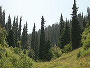
 Karakol is one of Kyrgyzstan's major tourist destinations, serving as a good starting point for the excellent hiking, trekking, skiing and mountaineering in the high central Tian Shan
to the south and east.
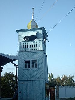
The town itself boasts a number of places that would be of interest to tourists, such as a very pretty wooden mosque
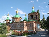
built by Chinese artisans for the local Dungans between 1907 and 1910 entirely without metal nails and a similarly appealing wooden Russian Orthodox church, the Holy Trinity Cathedral, completed in 1895, used as an officer's club during Soviet times, but now restored and in use again. The Regional Museum, following some sponsorship from the nearby Canadian gold mining concern
, has exhibits on the Issyk Kul Lake petroglyphs, Scythian bronze artifacts, and a short history of the geology and mineral exploitation in the region. There also is a small section of Russian colonial "gingerbread" style residential buildings. The Sunday livestock market is a good place to see remnants of the traditional nomadic rural life.
Przhevalsky's grave, a memorial park and a small museum dedicated to his and other Russian explorations in Central Asia are some 9 kilometres (5.6 mi) north of Karakol at Pristan Przhevalsky, overlooking the Mikhailovka inlet of Issyk Kul Lake where the former Soviet torpedo testing facilities were located. Facilities themselves are still a closed, military area.
Karakol is famous among skiers and snowboarders from former USSR for its ski resort.
Situated just 20 minutes from the town, the Karakol Ski Base provides services significantly better than those available at Shymbulak
, a resort outside Almaty, and has cheaper prices. Unlike Shymbulak
resort, the riding at Karakol includes forest areas as well as cleared trails.
Kyrgyzstan
Kyrgyzstan , officially the Kyrgyz Republic is one of the world's six independent Turkic states . Located in Central Asia, landlocked and mountainous, Kyrgyzstan is bordered by Kazakhstan to the north, Uzbekistan to the west, Tajikistan to the southwest and China to the east...
, about 150 kilometres (93.2 mi) from the Kyrgyzstan-China border and 380 kilometres (236.1 mi) from the capital Bishkek
Bishkek
Bishkek , formerly Pishpek and Frunze, is the capital and the largest city of Kyrgyzstan.Bishkek is also the administrative centre of Chuy Province which surrounds the city, even though the city itself is not part of the province but rather a province-level unit of Kyrgyzstan.The name is thought to...
. It is the administrative capital of Issyk Kul Province
Issyk Kul Province
Issyk Kul Province is a province of Kyrgyzstan. Its capital is Karakol. It is surrounded by Almaty Province, Kazakhstan , Chui Province , Naryn Province and Xinjiang, China ....
. To the north, on highway A363, is Tyup
Tyup
Tyup is a town in the Issyk Kul Province of Kyrgyzstan. It is a road junction town at the northeast corner of Lake Issyk Kul. To the west on A363 is Anan'yevo and to the south Karakol...
and to the southwest Jeti-Ögüz resort
Jeti-Ögüz resort
Jeti-Ögüz is a balneotherapic resort located at the north slope of Teskey Ala-Too mountain range near Issyk Kul in the Jeti-Oguz District of Issyk Kul Province of Kyrgyzstan, about 28 km west of Karakol. -History:...
.
History
A Russian military outpost founded on July 1, 1869, Karakol grew in the 19th century after explorers came to map the peaks and valleys separating Kyrgyzstan from ChinaChina
Chinese civilization may refer to:* China for more general discussion of the country.* Chinese culture* Greater China, the transnational community of ethnic Chinese.* History of China* Sinosphere, the area historically affected by Chinese culture...
. In the 1880s Karakol's population surged with an influx of Dungans, Chinese Muslims fleeing warfare in China.
In 1888, the Russian explorer Nicholay Przhevalsky died in Karakol of typhoid, while preparing for an expedition to Tibet
Tibet
Tibet is a plateau region in Asia, north-east of the Himalayas. It is the traditional homeland of the Tibetan people as well as some other ethnic groups such as Monpas, Qiang, and Lhobas, and is now also inhabited by considerable numbers of Han and Hui people...
, the city was renamed Przhevalsk in his honor. After local protests, the town was given its original name back in 1921—a decision reversed in 1939 by Stalin to celebrate the centenary of the explorer's birth. Karakol then remained Przhevalsk until the demise of the Soviet Union
Soviet Union
The Soviet Union , officially the Union of Soviet Socialist Republics , was a constitutionally socialist state that existed in Eurasia between 1922 and 1991....
in 1991. However the name has been retained by nearby Pristan'-Przheval'sk
Pristan'-Przheval'sk
Pristan'-Przheval'sk is a village in the Issyk Kul District, Issyk Kul Province of Kyrgyzstan. The town was named after the Russian geographer, Nikolai Mikhailovich Przhevalsky, who is buried nearby. It lies 12km north west of Karakol....
.
Nearby Issyk Kul Lake was used by the Soviet military as a testing site for torpedo propulsion and guidance systems, and Karakol was thus home to a sizable population of military personnel and their families. Karakol continues to be a major hub for visitors of Issyk Kul Lake.
Demographics
Karakol is fourth largest town in Kyrgyzstan after BishkekBishkek
Bishkek , formerly Pishpek and Frunze, is the capital and the largest city of Kyrgyzstan.Bishkek is also the administrative centre of Chuy Province which surrounds the city, even though the city itself is not part of the province but rather a province-level unit of Kyrgyzstan.The name is thought to...
, Osh
Osh
Osh is the second largest city in Kyrgyzstan, located in the Fergana Valley in the south of the country and often referred to as the "capital of the south". The city is at least 3,000 years old, and has served as the administrative center of Osh Province since 1939...
, and Jalal-Abad
Jalal-Abad
Jalalabat is the administrative and economic centre of Jalal-Abad Province in southwestern Kyrgyzstan, with a population of about 150,000...
. The population of Karakol, according to the Population and Housing Census of 2009, was 67,100.
Sights


Tian Shan
The Tian Shan , also spelled Tien Shan, is a large mountain system located in Central Asia. The highest peak in the Tian Shan is Victory Peak , ....
to the south and east.
The town itself boasts a number of places that would be of interest to tourists, such as a very pretty wooden mosque
Mosque
A mosque is a place of worship for followers of Islam. The word is likely to have entered the English language through French , from Portuguese , from Spanish , and from Berber , ultimately originating in — . The Arabic word masjid literally means a place of prostration...
built by Chinese artisans for the local Dungans between 1907 and 1910 entirely without metal nails and a similarly appealing wooden Russian Orthodox church, the Holy Trinity Cathedral, completed in 1895, used as an officer's club during Soviet times, but now restored and in use again. The Regional Museum, following some sponsorship from the nearby Canadian gold mining concern
Kumtor Gold Mine
Kumtor Gold Mine is an open-pit gold mining site in Issyk Kul Province of Kyrgyzstan located about 350 km southeast of the capital Bishkek and 80 km south of Lake Issyk-Kul near the border with China....
, has exhibits on the Issyk Kul Lake petroglyphs, Scythian bronze artifacts, and a short history of the geology and mineral exploitation in the region. There also is a small section of Russian colonial "gingerbread" style residential buildings. The Sunday livestock market is a good place to see remnants of the traditional nomadic rural life.
Przhevalsky's grave, a memorial park and a small museum dedicated to his and other Russian explorations in Central Asia are some 9 kilometres (5.6 mi) north of Karakol at Pristan Przhevalsky, overlooking the Mikhailovka inlet of Issyk Kul Lake where the former Soviet torpedo testing facilities were located. Facilities themselves are still a closed, military area.
Karakol is famous among skiers and snowboarders from former USSR for its ski resort.
Situated just 20 minutes from the town, the Karakol Ski Base provides services significantly better than those available at Shymbulak
Shymbulak
Shymbulak , also known as Chimbulak is a ski resort near Almaty, the largest city of Kazakhstan. It is located in the upper part of the Medeu Valley in the Zaiilisky Alatau mountain range, at the elevation of 2200 meters above sea level. The resort area is about 25 km south of Almaty city by...
, a resort outside Almaty, and has cheaper prices. Unlike Shymbulak
Shymbulak
Shymbulak , also known as Chimbulak is a ski resort near Almaty, the largest city of Kazakhstan. It is located in the upper part of the Medeu Valley in the Zaiilisky Alatau mountain range, at the elevation of 2200 meters above sea level. The resort area is about 25 km south of Almaty city by...
resort, the riding at Karakol includes forest areas as well as cleared trails.

