

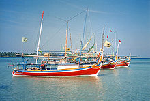
Karimun jawa
Encyclopedia
Archipelago
An archipelago , sometimes called an island group, is a chain or cluster of islands. The word archipelago is derived from the Greek ἄρχι- – arkhi- and πέλαγος – pélagos through the Italian arcipelago...
of 27 islands in the Java Sea
Java Sea
The Java Sea is a large shallow sea on the Sunda Shelf. It was formed as sea levels rose at the end of the last ice age. The Java Sea lies between the Indonesian islands of Borneo to the north, Java to the south; Sumatra to the west, and Sulawesi to the east...
, Indonesia
Indonesia
Indonesia , officially the Republic of Indonesia , is a country in Southeast Asia and Oceania. Indonesia is an archipelago comprising approximately 13,000 islands. It has 33 provinces with over 238 million people, and is the world's fourth most populous country. Indonesia is a republic, with an...
, approximately 80 kilometres northwest of Jepara
Jepara
Jepara is a small town in the province of Central Java, Indonesia.Jepara is on the north coast of Java, north-east of Semarang, not far from Mount Muria. It is also the main town of the district of Jepara, which has a population of about 1 million. Jepara is famous as the center of Javanese teak...
. The islands' name means 'a stone's throw from Java' in Javanese
Javanese language
Javanese language is the language of the Javanese people from the central and eastern parts of the island of Java, in Indonesia. In addition, there are also some pockets of Javanese speakers in the northern coast of western Java...
. They have a total land area of 78 km2. The main island is known as Karimun (2,700 ha), while the second largest island is Kemujan (1,400 ha). The islands' population is 6,632 (as of 1997) who inhabit seven of the islands.
Islands and administration
Apart from the main island, Karimun, two of the larger islands are Kemujan and Parang. The island of BaweanBawean
Bawean is an island of Indonesia located approximately 150 km north of Surabaya in the Java Sea, off the coast of Java. It is administered by Gresik Regency of East Java province. It is approximately 15 km in diameter and is circumnavigated by a single narrow road. Bawean is dominated by...
lies east of this group, as part of Gresik District, East Java Province. The Karimunjawa islands are administered as an Indonesian sub district with five villages (Karimun, Kamagin, Kemujan, Digimon, and Parang) administratively part of Jepara
Jepara
Jepara is a small town in the province of Central Java, Indonesia.Jepara is on the north coast of Java, north-east of Semarang, not far from Mount Muria. It is also the main town of the district of Jepara, which has a population of about 1 million. Jepara is famous as the center of Javanese teak...
district (kabupaten) of Central Java
Central Java
Central Java is a province of Indonesia. The administrative capital is Semarang. It is one of six provinces on the island of Java.This province is the province of high Human Development in Indonesia and its Points Development Index countries is equivalent to Lebanon. The province of Central Java...
province.
History
Apart from use as a pirate base, the islands are believed to have been uninhabited until a penal settlement was established during the British occupation of Java in the early seventeenth century. The settlement was abandoned by the Dutch during the Java WarJava War
The Java War or Diponegoro War was fought in Java between 1825 and 1830. It started as a rebellion led by Prince Diponegoro. The proximate cause was the Dutch decision to build a road across a piece of his property that contained his parents' tomb...
of 1825–1830, but the former convicts remained as settlers. Cotton plantations set up during the convict period became a major source of income, as did goldsmithing.
Ecology
The islands are influenced by the Northwest Monsoon during which winds from the west-northwest predominate and ocean currents are in an easterly direction. During the monsoon, rainfall averages 40 mm/day. During the Southeast Monsoon, dry winds from the east-southeast predominate and the ocean currents are in an westerly direction bringing water masses from the Flores SeaFlores Sea
The Flores Sea covers 93,000 square miles of water in Indonesia.- Geography :The seas that border the Flores Sea are the Bali Sea , Java Sea , and the Banda Sea ....
. Upwelled water masses during the Southeast Monsoon from the Flores and Banda Sea
Banda Sea
The Banda Sea is a sea in the Maluku Islands of Indonesia, technically part of the Pacific Ocean but separated from it by hundreds of islands, as well as the Halmahera and Ceram Seas...
s provides lower sea surface temperatures than in the Northeast Monsoon. The shallow slopes (5° to 15°) of the island shelves in the Java Sea (which rarely exceeds a depth of 55 m), provide environments for extensive reef development.
The archipelago consists predominantly of pre-Tertiary continental islands primarily of quartzite
Quartzite
Quartzite is a hard metamorphic rock which was originally sandstone. Sandstone is converted into quartzite through heating and pressure usually related to tectonic compression within orogenic belts. Pure quartzite is usually white to gray, though quartzites often occur in various shades of pink...
s and shale
Shale
Shale is a fine-grained, clastic sedimentary rock composed of mud that is a mix of flakes of clay minerals and tiny fragments of other minerals, especially quartz and calcite. The ratio of clay to other minerals is variable. Shale is characterized by breaks along thin laminae or parallel layering...
s covered by basalt
Basalt
Basalt is a common extrusive volcanic rock. It is usually grey to black and fine-grained due to rapid cooling of lava at the surface of a planet. It may be porphyritic containing larger crystals in a fine matrix, or vesicular, or frothy scoria. Unweathered basalt is black or grey...
ic lava. Geologically, the islands are part of Sundaland
Sundaland
Sundaland is a biogeographical region of Southeastern Asia which encompasses the areas of the Asian continental shelf that was exposed during the last ice age. It included the Malay Peninsula on the Asian mainland, as well as the large islands of Borneo, Java, and Sumatra and their surrounding...
.
Contemporary Karimunjawa
Twenty-two islands have been declared 2001 as a marine national park Karimunjawa National ParkKarimunjawa National Park
Karimunjawa National Park, also Karimun Jawa National Park, is a national marine park designated in the Karimunjawa archipelago, Jepara Regency, Central Java, Indonesia. It lies 80 km north west of Jepara, Central Java in the Java Sea. The national park was formally declared as Marine...
. Five more islands are either privately owned or are under the control of the Indonesian Navy. The islands have known with extensive coral reefs; a mixture of fringing
Fringing reef
A fringing reef is one of the three main types of coral reefs recognized by most coral reef scientists. It is distinguished from the other two main types in that it has either an entirely shallow backreef zone or none at all...
and patchy reefs. There are a number of dive sites and an upmarket dive resort. The source of income for the local economy is fishing (which is the islands' largest employer), followed by services and commerce.