Kilternan
Encyclopedia


County Wicklow
County Wicklow is a county in Ireland. It is part of the Mid-East Region and is also located in the province of Leinster. It is named after the town of Wicklow, which derives from the Old Norse name Víkingalág or Wykynlo. Wicklow County Council is the local authority for the county...
.
Separated from the continuous built-up Dublin area, it is a suburban village in rural surroundings at the crossroads of the R117
R117 road
The R117 road is a regional road in Ireland. The route starts Harcourt Road at the end of the South Circular Road on the southside of Dublin city centre...
and R116
R116 road
The R116 road is a regional road in Ireland which runs east-west from the N11 at Loughlinstown to the R115 in Ballyboden. It runs through the South of County Dublin for its entire length...
regional road
Regional road
A regional road in Ireland is a class of road not forming a major route , but nevertheless forming a link in the national route network. There are over 11,600 kilometres of regional roads. Regional roads are numbered with three digit route numbers, prefixed by "R" A regional road in Ireland is a...
s.
Proposed development scheduled to begin in 2009 would have expanded the urban area, but the plans were forestalled by the bursting of the property bubble in Ireland
2008–2011 Irish financial crisis
The 2008–2011 Irish financial crisis, which had stemmed from the financial crisis of 2008, is a major political and economic crisis in Ireland that is partly responsible for the country falling into recession for the first time since the 1980s...
.
Kilternan's most notable buildings are the Church of Ireland
Church of Ireland
The Church of Ireland is an autonomous province of the Anglican Communion. The church operates in all parts of Ireland and is the second largest religious body on the island after the Roman Catholic Church...
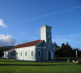
Parish Church of Kilternan which dates from 1826, the timber-built Catholic Church of Our Lady of the Wayside (1937), or 'The Blue Church' as it is known locally after its Marian colour, and the Golden Ball pub. These names are joined at the local soccer club, Wayside Celtic
Wayside Celtic F.C.
Wayside Celtic F.C. are a football club who compete in the Leinster Senior League. They play their home games at the Golden Ball in Kilternan, Dublin, Ireland...
whose ground is known as The Golden Ball.
Kilternan lacks a traditional village centre or 'Main Street'. It is the location of Ireland's only (artificial) ski slope.
Spelling of the name
Road signs are somewhat confused regarding the correct spelling of the name of the area. For example; signs on the M50 motorwayM50 motorway (Ireland)
The M50 motorway is a motorway in Ireland running in a C-shaped ring around the north-eastern, northern, western and southern sides of the capital city, Dublin. The northern end of the route is located at the entrance to the Dublin Port Tunnel. Anti-clockwise it heads northwest through the tunnel...
(Junction 15) call it Kilternan while signs at the junction on the adjoining roads refer to "Kiltiernan", even though both sets were erected at roughly the same time. Local government documents and ordnance survey maps refer to Kiltiernan while many local people spell the name without the "i". Locally, Kilternan is the most acceptable form.
See also
- List of towns and villages in Ireland

