Kongur Tagh
Encyclopedia
Kongur Tagh or Kongkoerh (Uyghur
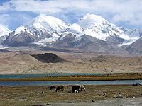
: ; ) (also referred to as Kongur) is at 7,649 m the highest mountain wholly within the Xinjiang Uyghur Autonomous Region.

and visible from Karakul Lake
. Some sources use "Kongur Shan" mistakenly to refer to the peak itself. The Kongur and Muztagh Ata ranges are sometimes considered a subrange of either the Kunlun Mountains
or the Pamir Mountains
. In either case Kongur Tagh would be the highest summit of those ranges.
Due to its remoteness and being hidden by nearby peaks, Kongur was not discovered by Europeans until 1900. However, the building of the Karakorum Highway from Pakistan
to China
, which runs past nearby Tashkurgan
and Karakul Lake, has now made it more accessible.
Administratively, the Kongur Range is within Akto County
.
The first ascent
of Kongur Tagh was completed in 1981 by a British expedition consisting of Chris Bonington
, Al Rouse, Peter Boardman
and Joe Tasker
.
of 840 m (2,756 ft). It was first climbed in 1956.
Uyghur language
Uyghur , formerly known as Eastern Turk, is a Turkic language with 8 to 11 million speakers, spoken primarily by the Uyghur people in the Xinjiang Uyghur Autonomous Region of Western China. Significant communities of Uyghur-speakers are located in Kazakhstan and Uzbekistan, and various other...
: ; ) (also referred to as Kongur) is at 7,649 m the highest mountain wholly within the Xinjiang Uyghur Autonomous Region.

Geography
Kongur Tagh is within a range called the Kongur Shan , located just north of Muztagh AtaMuztagh Ata
Muztagh Ata, or Muztagata , is the second highest of the mountains which form the northern edge of the Tibetan Plateau . It is sometimes regarded as being part of the Kunlun Shan, although physically it is more closely connected to the Pamirs...
and visible from Karakul Lake
Karakul (China)
The Karakul or Karakuli is a lake located 196 km from Kashgar, Xinjiang province, China, in Akto County, Kizilsu Kirgiz Autonomous Prefecture on the Karakoram Highway, before reaching Tashkurgan, the Khunjerab Pass on the China - Pakistan border and Sost in Pakistan...
. Some sources use "Kongur Shan" mistakenly to refer to the peak itself. The Kongur and Muztagh Ata ranges are sometimes considered a subrange of either the Kunlun Mountains
Kunlun Mountains
The Kunlun Mountains are one of the longest mountain chains in Asia, extending more than 3,000 km. In the broadest sense, it forms the northern edge of the Tibetan Plateau south of the Tarim Basin and the Gansu Corridor and continues east south of the Wei River to end at the North China Plain.The...
or the Pamir Mountains
Pamir Mountains
The Pamir Mountains are a mountain range in Central Asia formed by the junction or knot of the Himalayas, Tian Shan, Karakoram, Kunlun, and Hindu Kush ranges. They are among the world’s highest mountains and since Victorian times they have been known as the "Roof of the World" a probable...
. In either case Kongur Tagh would be the highest summit of those ranges.
Due to its remoteness and being hidden by nearby peaks, Kongur was not discovered by Europeans until 1900. However, the building of the Karakorum Highway from Pakistan
Pakistan
Pakistan , officially the Islamic Republic of Pakistan is a sovereign state in South Asia. It has a coastline along the Arabian Sea and the Gulf of Oman in the south and is bordered by Afghanistan and Iran in the west, India in the east and China in the far northeast. In the north, Tajikistan...
to China
China
Chinese civilization may refer to:* China for more general discussion of the country.* Chinese culture* Greater China, the transnational community of ethnic Chinese.* History of China* Sinosphere, the area historically affected by Chinese culture...
, which runs past nearby Tashkurgan
Tashkurgan
- Karakoram Highway :Today Tashkurgan is on the Karakoram Highway which follows the old Silk Road route from China to Pakistan. Accommodation is available and it is a recommended overnight stop for road travellers from China to Pakistan in order to have the best chance of crossing the snow-prone...
and Karakul Lake, has now made it more accessible.
Administratively, the Kongur Range is within Akto County
Akto County
The Akto County is a county in the Xinjiang Uyghur Autonomous Region and is under the administration of the Kizilsu Kirghiz Autonomous Prefecture. It contains an area of 24,107 km2...
.
Climbing history
The first attempt to climb Kongur Tagh was made in 1956 but the party aborted the attempt when it realized it was beyond their abilities.The first ascent
First ascent
In climbing, a first ascent is the first successful, documented attainment of the top of a mountain, or the first to follow a particular climbing route...
of Kongur Tagh was completed in 1981 by a British expedition consisting of Chris Bonington
Chris Bonington
Sir Christian John Storey Bonington, CVO, CBE, DL is a British mountaineer.His career has included nineteen expeditions to the Himalayas, including four to Mount Everest and the first ascent of the south face of Annapurna.-Early life and expeditions:Educated at University College School in...
, Al Rouse, Peter Boardman
Peter Boardman
Peter Boardman was a British climber, Everest summiteer, and author of several mountaineering books.-Early life:...
and Joe Tasker
Joe Tasker
Joe Tasker was one of the most talented British climbers during the late 1970s and early 1980s. Born into a traditional Roman Catholic family, he was one of ten children and spent his early childhood in Port Clarence, Middlesbrough then attended Ushaw Seminary, County Durham between the ages of 13...
.
Elevation
This is taken from the Guide to Mountaineering in China. Some Chinese authorities give it 7,719 m, but evidence against this higher elevation is given here.Kongur Tiube
Kongur Tagh has a significant subpeak known as Kongur Tiube (also Kongur Tiubie / Jiubie and Kungur Tjube Tagh), 38°36′57"N 75°11′44"E; elevation = 7,530 m (24,705 ft).Ranked 47th It is moderately independent, with a topographic prominenceTopographic prominence
In topography, prominence, also known as autonomous height, relative height, shoulder drop , or prime factor , categorizes the height of the mountain's or hill's summit by the elevation between it and the lowest contour line encircling it and no higher summit...
of 840 m (2,756 ft). It was first climbed in 1956.

