Kreuztal
Encyclopedia
Kreuztal is a town in the Siegen-Wittgenstein
district, in North Rhine-Westphalia
, Germany
.
and lies at the western edge of the Rothaargebirge
about 10 km north of Siegen
.
Across the municipal area from the east flows the Ferndorfbach, swinging to the south in the inner town and leaving the municipal area through the constituent community of Buschhütten.
In the northern municipal area rises the Littfe, which then runs through the constituent communities of Burgholdinghausen, Littfeld, Krombach, Eichen and Fellinghausen before emptying into the Ferndorfbach in the inner town. Further tributary brooks to the Littfe are the Langebach, the Heimkäuser Bach, the Breitenbach, the Krombach, the Stendenbach and the Bockenbach.
In the town's west end rises the Heesbach, which then runs through the constituent communities of Oberhees, Mittelhees, Junkernhees and Fellinghausen, emptying into the Littfe at the footbridge. One tributary to the Hees is the Ostheldener Bach, which feeds the Robertsweier (pond). The Berghäuser Bach, which flows through the Berghäuser Weier (another pond), empties into the Ostheldener Bach downstream from the Robertsweier.
Mountains. The southernmost constituent community of Buschhütten gives way to the Sieg
gorge to the south. While the bedrock
contains many layers of iron
-bearing rock, the surface is formed of weathered clayey-sandy earth.
The town's highest point is the Hoher Wald at 655 m above sea level
, and its lowest point is to be found in Buschhütten where the Ferndorfbach leaves the municipal area at a height of 260 m above sea level. The municipal area's north-south extent is 12 km, and its east-west extent is 11 km.
 The town, lying in the northwestern part of the district, borders in the south on Siegen
, in the west on Freudenberg
and Wenden
, in the north on Kirchhundem
and Olpe
and in the east on Hilchenbach
and Netphen
. The town is shaped by the valleys of the Ferndorfbach, Littfe and Hees, which together form a cross-shaped valley.
The town's highest elevation is the mountain Hoher Wald at 655 m above sea level. The peak is however not open to the public, as it belongs to the Bundeswehr
. Other mountains are the Hölzenberg 626 m above sea level, Kindelsberg 617.9 m above sea level (the town's landmark), the Martinshardt 616.1 m above sea level, the Ziegenberg 521 m above sea level, the Wilder Stein 478.9 m above sea level, die Rodenull 436 m above sea level, the Köpfchen 407.4 m above sea level, the Pfaffenberg 398.7 m above sea level, the Buberg, the Pühlsberg, the Krähenberg, the Altenhahn, the Löherhauberg, the Höhberg, the Rohberg, the Wolfshagen, the Mühlberg, the Mühlenkopf, the Kilgeshahn, the Siegerberg, the Kohlenberg, the Hohler Stein, the Dudeltätsch and the Heidlofsberg.
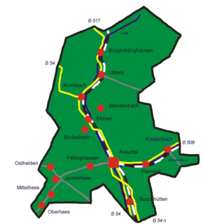 The town is made up of the centres of Burgholdinghausen, Krombach and Eichen in the north, Kreuztal in the middle, Osthelden, Oberhees, Mittelhees, Junkernhees and Fellinghausen in the west, and Ferndorf, Kredenbach, Langenau and Buschhütten in the south.
The first documentary mentions go back to 1067, among which are found a place called "Berentraph", the later constituent community of Ferndorf, one of the earliest named places in the Siegerland
. Until the town was founded, Ferndorf was the old Amt
's namesake.
The constituent community of Ernsdorf was first mentioned in a document as "Erinstorff" in 1417-1419. During the time of the Confederation of the Rhine
, Ernsdorf was the local mayor's seat.
 The name that the town now bears first cropped up in 1826 in the baptismal register of the community of Ferndorf.
Development in the town was sparked by the railway. In 1861, the Ruhr-Sieg line opened, leading Kreuztal to become a railway hub by 1880. Up to 1888, a spur to Erndtebrück
, Bad Laasphe
and Marburg
was built. Also in the plans was a line to Olpe
and Meinerzhagen
, but this was only partly finished, as far as Krummenerl.
Note: FW and BGK are citizens' coalitions.
might heraldically be described thus: Party per fess, above, in Or a horn azure, below, in azure a saltire Or.
The horn charge is Ferndorf's old arms, and is also the emblem of the princely house of Nassau-Orange, and thereby also a reference to the town's past. The saltire is a reference to the local geography, as the valleys form a cross shape, and it is a canting
symbol, too, since "Kreuztal" literally means "Crossdale" in German
(that name does, of course, refer to the geography). Gold and blue are Nassau's colours.http://www.ngw.nl/int/dld/k/kreuztal.htm
, Brandenburg
Ferndorf
, Carinthia
, Austria
A partnership with a Polish
town is also being pursued.
 In Ferndorf is the local history museum (Heimatmuseum). On show here in about 200 m² are finds from prehistory and early history, as well as handicrafts and exhibits about home décor in the 17th and 18th centuries.
near Bonn
.
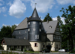
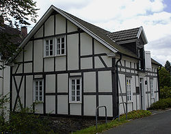
around it. In 1698, it was expanded by being given a half-timbered
gable. Two outbuildings, the former brandy
distillery and the old mill from 1796, are also preserved.
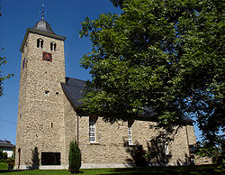
hall church with a western tower and a three-halled nave with a tower built before it.
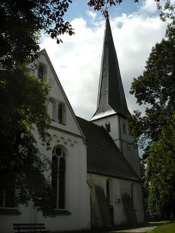
was made in 1764 and the altar table in 1781. The tower that stands today was built in 1706, after the earlier tower was destroyed by a lightning
strike.
and town archive
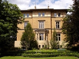
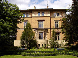
. The park was named after the manufacturing family Dresler, who once owned the park. In the park are found the "yellow villa", the "white villa", the wagon shed, the coachhouse (today a restaurant and inn called the Kutscherhaus – the same in German), the music pavilion and the garden house. The wagon shed houses a daycare centre.
-Müsen are found the remains of a settlement from the 13th century. A hiking trail leads through this former mining
settlement. Archaeological
finds are on display at the mining museum in Hilchenbach-Müsen.
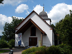
s, and indeed was the tallest when it was built. The rotor is about 66 m wide. The tower itself is a steel lattice and weighs roughly 145 t. The power house alone weighs 63 t all together. Yearly, it generates about 3 GWh.http://www.ewiger-fuhrmann.de/
to Soest
and from Wipperfürth
to the Netherlands
.
on the second Sunday in May, an event regarded as one of Germany's most important triathlons.
to the south. Sometime in 2006, the B 54n is to be extended to Krombach in the north of the municipal area, where it will one day connect to the A 4, which is likewise under construction.
Eastwards run Federal Highways B 508 towards Hilchenbach and B 517 towards Kirchhundem and Lennestadt
.
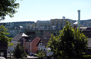 Parallel to the highways run the railways. From north to south runs the Ruhr-Sieg line, and east-west runs the Rothaar Railway
through the Wittgensteiner Land towards Marburg
. Within the municipal area are six railway stations or halts (as of 2003). The central station
lies in Kreuztal (main town). Halts are to be found in Littfeld, Eichen, Ferndorf and Kredenbach. Although it serves Dahlbruch, a constituent community of Hilchenbach, this station is nonetheless within Kreuztal's municipal area. Kreuztal also has South Westphalia's only marshalling yard, and connected thereto is the region's only railway container
terminal. This is found in Langenau, and beyond its national functions, it also serves regional goods transport in the Sauerland and Siegerland. To and from the Kreuztal Marshalling Yard, trains run, by way of the national marshalling yard in Hagen
-Vorhalle, to all destinations that can be reached by rail.
The town is connected by many regional buslines with surrounding towns. Since 1998, South Westphalia's first private bus service (Bürgerbus) has been running. On regional trains and buses, the tariff is that used by the South Westphalia Transport Community (Verkehrsgemeinschaft Westfalen-Süd).
Kreuztal can also be reached through the Siegerland Airport in the south of the district.
Siegen-Wittgenstein
Siegen-Wittgenstein is a Kreis in the southeast of North Rhine-Westphalia, Germany. Neighboring districts are Olpe, Hochsauerlandkreis, Waldeck-Frankenberg, Marburg-Biedenkopf, Lahn-Dill, Westerwaldkreis, Altenkirchen.-History:...
district, in North Rhine-Westphalia
North Rhine-Westphalia
North Rhine-Westphalia is the most populous state of Germany, with four of the country's ten largest cities. The state was formed in 1946 as a merger of the northern Rhineland and Westphalia, both formerly part of Prussia. Its capital is Düsseldorf. The state is currently run by a coalition of the...
, Germany
Germany
Germany , officially the Federal Republic of Germany , is a federal parliamentary republic in Europe. The country consists of 16 states while the capital and largest city is Berlin. Germany covers an area of 357,021 km2 and has a largely temperate seasonal climate...
.
Location
Kreuztal is a town in the low mountains of the northern SiegerlandSiegerland
The Siegerland is a region of Germany covering the old district of Siegen and the upper part of the district of Altenkirchen, belonging to the Rhineland-Palatinate adjoining it to the west.Geologically, the Siegerland belongs to the Rheinisches Schiefergebirge...
and lies at the western edge of the Rothaargebirge
Rothaargebirge
The Rothaargebirge is a low mountain range reaching heights of up to 843.1 m in North Rhine-Westphalia and Hesse, Germany....
about 10 km north of Siegen
Siegen
Siegen is a city in Germany, in the south Westphalian part of North Rhine-Westphalia.It is located in the district of Siegen-Wittgenstein in the Arnsberg region...
.
Across the municipal area from the east flows the Ferndorfbach, swinging to the south in the inner town and leaving the municipal area through the constituent community of Buschhütten.
In the northern municipal area rises the Littfe, which then runs through the constituent communities of Burgholdinghausen, Littfeld, Krombach, Eichen and Fellinghausen before emptying into the Ferndorfbach in the inner town. Further tributary brooks to the Littfe are the Langebach, the Heimkäuser Bach, the Breitenbach, the Krombach, the Stendenbach and the Bockenbach.
In the town's west end rises the Heesbach, which then runs through the constituent communities of Oberhees, Mittelhees, Junkernhees and Fellinghausen, emptying into the Littfe at the footbridge. One tributary to the Hees is the Ostheldener Bach, which feeds the Robertsweier (pond). The Berghäuser Bach, which flows through the Berghäuser Weier (another pond), empties into the Ostheldener Bach downstream from the Robertsweier.
Geology
The municipal area is part of the Rheinisches Schiefergebirge, or Rhenish SlateSlate
Slate is a fine-grained, foliated, homogeneous metamorphic rock derived from an original shale-type sedimentary rock composed of clay or volcanic ash through low-grade regional metamorphism. The result is a foliated rock in which the foliation may not correspond to the original sedimentary layering...
Mountains. The southernmost constituent community of Buschhütten gives way to the Sieg
Sieg
The Sieg is a river in North Rhine-Westphalia and Rhineland-Palatinate, Germany named after the Sigambrer. It is a right tributary of the Rhine and 153 kilometres in length....
gorge to the south. While the bedrock
Bedrock
In stratigraphy, bedrock is the native consolidated rock underlying the surface of a terrestrial planet, usually the Earth. Above the bedrock is usually an area of broken and weathered unconsolidated rock in the basal subsoil...
contains many layers of iron
Iron
Iron is a chemical element with the symbol Fe and atomic number 26. It is a metal in the first transition series. It is the most common element forming the planet Earth as a whole, forming much of Earth's outer and inner core. It is the fourth most common element in the Earth's crust...
-bearing rock, the surface is formed of weathered clayey-sandy earth.
Municipal area's extent
The municipal area covers 70.96 km². This breaks down as follows:- 60.02% wooded
- 16.41% agricultural
- 14.49% buildings and yards7.09% transport2.26% other
The town's highest point is the Hoher Wald at 655 m above sea level
Sea level
Mean sea level is a measure of the average height of the ocean's surface ; used as a standard in reckoning land elevation...
, and its lowest point is to be found in Buschhütten where the Ferndorfbach leaves the municipal area at a height of 260 m above sea level. The municipal area's north-south extent is 12 km, and its east-west extent is 11 km.
Neighbouring communities

Siegen
Siegen is a city in Germany, in the south Westphalian part of North Rhine-Westphalia.It is located in the district of Siegen-Wittgenstein in the Arnsberg region...
, in the west on Freudenberg
Freudenberg, Westphalia
Freudenberg is a town in the Siegen-Wittgenstein district, in North Rhine-Westphalia, Germany.The town lies on the German-Dutch holiday road called the Orange Route, joining towns, cities and regions associated with the House of Orange.- Location :...
and Wenden
Wenden
Wenden is a community in North Rhine-Westphalia, Germany. It belongs to the Olpe district in the Sauerland. It lies 10 km south of Olpe and approx. 20 km northwest of Siegen.- Location :...
, in the north on Kirchhundem
Kirchhundem
Kirchhundem is a community in North Rhine-Westphalia, Germany. It belongs to the Olpe district.- Location :The community of Kirchhundem lies in the Olpe district’s southeast in the south Sauerland and belongs to the so-called Bilsteiner Bergland...
and Olpe
Olpe, Germany
Olpe is situated in the foothills of the Ebbegebirge in North Rhine-Westphalia, roughly 60 km east of Cologne and 20 km northwest of Siegen. It is part of the Regierungsbezirk of Arnsberg and is the seat of the district of Olpe.- Location :...
and in the east on Hilchenbach
Hilchenbach
Hilchenbach is a town in the Siegen-Wittgenstein Kreis of North Rhine-Westphalia, Germany.-Location: The map shows Hilchenbach's location in Siegen-Wittgenstein district. It is about 15 km northeast of Siegen...
and Netphen
Netphen
Netphen is a town in the Siegen-Wittgenstein district, in North Rhine-Westphalia, Germany. It lies on the river Sieg, roughly 7 km northeast of Siegen.-Location:...
. The town is shaped by the valleys of the Ferndorfbach, Littfe and Hees, which together form a cross-shaped valley.
The town's highest elevation is the mountain Hoher Wald at 655 m above sea level. The peak is however not open to the public, as it belongs to the Bundeswehr
Bundeswehr
The Bundeswehr consists of the unified armed forces of Germany and their civil administration and procurement authorities...
. Other mountains are the Hölzenberg 626 m above sea level, Kindelsberg 617.9 m above sea level (the town's landmark), the Martinshardt 616.1 m above sea level, the Ziegenberg 521 m above sea level, the Wilder Stein 478.9 m above sea level, die Rodenull 436 m above sea level, the Köpfchen 407.4 m above sea level, the Pfaffenberg 398.7 m above sea level, the Buberg, the Pühlsberg, the Krähenberg, the Altenhahn, the Löherhauberg, the Höhberg, the Rohberg, the Wolfshagen, the Mühlberg, the Mühlenkopf, the Kilgeshahn, the Siegerberg, the Kohlenberg, the Hohler Stein, the Dudeltätsch and the Heidlofsberg.
Constituent communities


History
The town of Kreuztal as it stands now is the child of the municipal reform of 1 January 1969. It came into being through the voluntary merger of the communities of Burgholdinghausen, Buschhütten, Eichen, Fellinghausen, Ferndorf, Kredenbach, Kreuztal, Krombach, Littfeld, Mittelhees, Oberhees and Osthelden.The first documentary mentions go back to 1067, among which are found a place called "Berentraph", the later constituent community of Ferndorf, one of the earliest named places in the Siegerland
Siegerland
The Siegerland is a region of Germany covering the old district of Siegen and the upper part of the district of Altenkirchen, belonging to the Rhineland-Palatinate adjoining it to the west.Geologically, the Siegerland belongs to the Rheinisches Schiefergebirge...
. Until the town was founded, Ferndorf was the old Amt
Amt (subnational entity)
Amt is a type of administrative division governing a group of municipalities, today only found in Germany, but formerly also common in northern European countries. Its size and functions differ by country and the term is roughly equivalent to a U.S...
's namesake.
The constituent community of Ernsdorf was first mentioned in a document as "Erinstorff" in 1417-1419. During the time of the Confederation of the Rhine
Confederation of the Rhine
The Confederation of the Rhine was a confederation of client states of the First French Empire. It was formed initially from 16 German states by Napoleon after he defeated Austria's Francis II and Russia's Alexander I in the Battle of Austerlitz. The Treaty of Pressburg, in effect, led to the...
, Ernsdorf was the local mayor's seat.

Development in the town was sparked by the railway. In 1861, the Ruhr-Sieg line opened, leading Kreuztal to become a railway hub by 1880. Up to 1888, a spur to Erndtebrück
Erndtebrück
Erndtebrück is a municipality in the Siegen-Wittgenstein district, in North Rhine-Westphalia, Germany.-Location:Erndtebrück situated on the river Eder in the Rothaargebirge, approx...
, Bad Laasphe
Bad Laasphe
Bad Laasphe is a town in North Rhine-Westphalia, Germany, in the Siegen-Wittgenstein district.-Location:The town of Bad Laasphe lies in the upper Lahn Valley, near the stately home of Wittgenstein Castle in the former Wittgenstein district...
and Marburg
Marburg
Marburg is a city in the state of Hesse, Germany, on the River Lahn. It is the main town of the Marburg-Biedenkopf district and its population, as of March 2010, was 79,911.- Founding and early history :...
was built. Also in the plans was a line to Olpe
Olpe, Germany
Olpe is situated in the foothills of the Ebbegebirge in North Rhine-Westphalia, roughly 60 km east of Cologne and 20 km northwest of Siegen. It is part of the Regierungsbezirk of Arnsberg and is the seat of the district of Olpe.- Location :...
and Meinerzhagen
Meinerzhagen
Meinerzhagen is a town in the Märkischer Kreis, North Rhine-Westphalia, Germany.-Geography:Meinerzhagen is located in the hills of the Sauerland. The highest elevation is the Nordhelle with 663 m above sea level, the lowest elevation at the Lister dam with 319m...
, but this was only partly finished, as far as Krummenerl.
Town council
The town council's 38 seats are apportioned thus, in accordance with municipal elections held on 26 September 2004:| CDU Christian Democratic Union (Germany) The Christian Democratic Union of Germany is a Christian democratic and conservative political party in Germany. It is regarded as on the centre-right of the German political spectrum... |
SPD Social Democratic Party of Germany The Social Democratic Party of Germany is a social-democratic political party in Germany... |
Greens Alliance '90/The Greens Alliance '90/The Greens is a green political party in Germany, formed from the merger of the German Green Party and Alliance 90 in 1993. Its leaders are Claudia Roth and Cem Özdemir... |
FDP Free Democratic Party (Germany) The Free Democratic Party , abbreviated to FDP, is a centre-right classical liberal political party in Germany. It is led by Philipp Rösler and currently serves as the junior coalition partner to the Union in the German federal government... |
FW | BGK | total | |
| 2004 | 16 | 14 | 3 | 2 | 2 | 1 | 38 |
Note: FW and BGK are citizens' coalitions.

Coat of arms
Kreuztal's civic coat of armsCoat of arms
A coat of arms is a unique heraldic design on a shield or escutcheon or on a surcoat or tabard used to cover and protect armour and to identify the wearer. Thus the term is often stated as "coat-armour", because it was anciently displayed on the front of a coat of cloth...
might heraldically be described thus: Party per fess, above, in Or a horn azure, below, in azure a saltire Or.
The horn charge is Ferndorf's old arms, and is also the emblem of the princely house of Nassau-Orange, and thereby also a reference to the town's past. The saltire is a reference to the local geography, as the valleys form a cross shape, and it is a canting
Canting arms
Canting arms are heraldic bearings that represent the bearer's name in a visual pun or rebus. The term cant came into the English language from Anglo-Norman cant, meaning song or singing, from Latin cantāre, and English cognates include canticle, chant, accent, incantation and recant.Canting arms –...
symbol, too, since "Kreuztal" literally means "Crossdale" in German
German language
German is a West Germanic language, related to and classified alongside English and Dutch. With an estimated 90 – 98 million native speakers, German is one of the world's major languages and is the most widely-spoken first language in the European Union....
(that name does, of course, refer to the geography). Gold and blue are Nassau's colours.http://www.ngw.nl/int/dld/k/kreuztal.htm
Town partnerships
NauenNauen
Nauen is a town in the Havelland district, in Brandenburg, Germany. It is situated 38 km west of Berlin and 26 km northwest of Potsdam.-History:...
, Brandenburg
Brandenburg
Brandenburg is one of the sixteen federal-states of Germany. It lies in the east of the country and is one of the new federal states that were re-created in 1990 upon the reunification of the former West Germany and East Germany. The capital is Potsdam...
Ferndorf
Ferndorf
Ferndorf is a municipality in the district of Villach-Land in the Austrian state of Carinthia. It is situated on a small range of the Nock Mountains between the Drava Valley and the Millstätter See...
, Carinthia
Carinthia (state)
Carinthia is the southernmost Austrian state or Land. Situated within the Eastern Alps it is chiefly noted for its mountains and lakes.The main language is German. Its regional dialects belong to the Southern Austro-Bavarian group...
, Austria
Austria
Austria , officially the Republic of Austria , is a landlocked country of roughly 8.4 million people in Central Europe. It is bordered by the Czech Republic and Germany to the north, Slovakia and Hungary to the east, Slovenia and Italy to the south, and Switzerland and Liechtenstein to the...
A partnership with a Polish
Poland
Poland , officially the Republic of Poland , is a country in Central Europe bordered by Germany to the west; the Czech Republic and Slovakia to the south; Ukraine, Belarus and Lithuania to the east; and the Baltic Sea and Kaliningrad Oblast, a Russian exclave, to the north...
town is also being pursued.
Theatre
At the Stadthalle, lying in the school centre, there are regular theatrical productions.Museums

Kindelsbergturm
On the Kindelsberg, the town's second highest peak at 618 m, stands the 22 m-high Kindelsbergturm (tower). It was built in 1907 by the Sauerländischer Gebirgsverein (Sauerland Mountain Club, or SGV) and has had further remodelling in the course of its history. From the top is a view over the municipal area, and in good weather, the viewer can even see into the SiebengebirgeSiebengebirge
The Siebengebirge is a German range of hills to the East of the Rhine, southeast of Bonn, consisting of more than 40 mountains and hills. It is located in the municipalities of Bad Honnef and Königswinter. It is of volcanic origin and came into being between 28 and 15 million years ago...
near Bonn
Bonn
Bonn is the 19th largest city in Germany. Located in the Cologne/Bonn Region, about 25 kilometres south of Cologne on the river Rhine in the State of North Rhine-Westphalia, it was the capital of West Germany from 1949 to 1990 and the official seat of government of united Germany from 1990 to 1999....
.
Schloss Junkernhees
The stately home of Junkernhees was originally built in 1523 by a Sir Adam (der Ritter Adam) with a moatMoat
A moat is a deep, broad ditch, either dry or filled with water, that surrounds a castle, other building or town, historically to provide it with a preliminary line of defence. In some places moats evolved into more extensive water defences, including natural or artificial lakes, dams and sluices...
around it. In 1698, it was expanded by being given a half-timbered
Timber framing
Timber framing , or half-timbering, also called in North America "post-and-beam" construction, is the method of creating structures using heavy squared off and carefully fitted and joined timbers with joints secured by large wooden pegs . It is commonplace in large barns...
gable. Two outbuildings, the former brandy
Brandy
Brandy is a spirit produced by distilling wine. Brandy generally contains 35%–60% alcohol by volume and is typically taken as an after-dinner drink...
distillery and the old mill from 1796, are also preserved.
Ferndorf Evangelical Church
This was built in the first half of the 13th century as Saint Lawrence's. It consists of a late RomanesqueRomanesque architecture
Romanesque architecture is an architectural style of Medieval Europe characterised by semi-circular arches. There is no consensus for the beginning date of the Romanesque architecture, with proposals ranging from the 6th to the 10th century. It developed in the 12th century into the Gothic style,...
hall church with a western tower and a three-halled nave with a tower built before it.

Krombach Evangelical Reformed Church
Built in 1250, the main choir is one hall, and the nave two and a half. The pulpitPulpit
Pulpit is a speakers' stand in a church. In many Christian churches, there are two speakers' stands at the front of the church. Typically, the one on the left is called the pulpit...
was made in 1764 and the altar table in 1781. The tower that stands today was built in 1706, after the earlier tower was destroyed by a lightning
Lightning
Lightning is an atmospheric electrostatic discharge accompanied by thunder, which typically occurs during thunderstorms, and sometimes during volcanic eruptions or dust storms...
strike.
Dreslers Park
These buildings, built between 1860 and 1880, nowadays house the citizen and culture centre with a libraryLibrary
In a traditional sense, a library is a large collection of books, and can refer to the place in which the collection is housed. Today, the term can refer to any collection, including digital sources, resources, and services...
and town archive
Archive
An archive is a collection of historical records, or the physical place they are located. Archives contain primary source documents that have accumulated over the course of an individual or organization's lifetime, and are kept to show the function of an organization...
. The park was named after the manufacturing family Dresler, who once owned the park. In the park are found the "yellow villa", the "white villa", the wagon shed, the coachhouse (today a restaurant and inn called the Kutscherhaus – the same in German), the music pavilion and the garden house. The wagon shed houses a daycare centre.
Altenberg
At the Altenberg between the constituent community of Littfeld and HilchenbachHilchenbach
Hilchenbach is a town in the Siegen-Wittgenstein Kreis of North Rhine-Westphalia, Germany.-Location: The map shows Hilchenbach's location in Siegen-Wittgenstein district. It is about 15 km northeast of Siegen...
-Müsen are found the remains of a settlement from the 13th century. A hiking trail leads through this former mining
Mining
Mining is the extraction of valuable minerals or other geological materials from the earth, from an ore body, vein or seam. The term also includes the removal of soil. Materials recovered by mining include base metals, precious metals, iron, uranium, coal, diamonds, limestone, oil shale, rock...
settlement. Archaeological
Archaeology
Archaeology, or archeology , is the study of human society, primarily through the recovery and analysis of the material culture and environmental data that they have left behind, which includes artifacts, architecture, biofacts and cultural landscapes...
finds are on display at the mining museum in Hilchenbach-Müsen.

"Ewiger Fuhrmann" wind generator
The "Ewiger Fuhrmann" – Everlasting Wagoner – is at 150 m one of the world's tallest wind generatorWind generator
A wind generator is a device that generates electrical power from wind energy.Wind generators have traditionally been wind turbines, i.e. a propeller attached to an electric generator attached to appropriate electronics to attach it to the electrical grid or to charge batteries.Recently, however, a...
s, and indeed was the tallest when it was built. The rotor is about 66 m wide. The tower itself is a steel lattice and weighs roughly 145 t. The power house alone weighs 63 t all together. Yearly, it generates about 3 GWh.http://www.ewiger-fuhrmann.de/
Kaiser Wilhelm Gallery
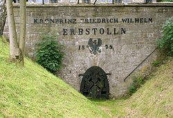
In the heart of the town is the former entry area to the Kaiser Wilhelm Gallery (an underground gallery) with its Stollenhaus ("Gallery House"), which now houses the town administration's office for schools, kindergartens and sport.Gasthof Hambloch
The Hamblock Inn lies in the constituent community of Krombach and can look back on 500 years of tradition. Even today, the hitching posts bear witness to the long-distance trade of yore from FrankfurtFrankfurt
Frankfurt am Main , commonly known simply as Frankfurt, is the largest city in the German state of Hesse and the fifth-largest city in Germany, with a 2010 population of 688,249. The urban area had an estimated population of 2,300,000 in 2010...
to Soest
Soest, Germany
Soest is a town in North Rhine-Westphalia, Germany. It is the capital of the Soest district. After Lippstadt, a neighbouring town, Soest is the second biggest town in its district.-Geography:...
and from Wipperfürth
Wipperfürth
thumb|310px|Map of the citythumb|250px|Town hallWipperfürth is a municipality in the Oberbergischer Kreis of North Rhine-Westfalia, Germany, about 40 km north-east of Cologne, and the oldest town in the Bergischen Land.-History:...
to the Netherlands
Netherlands
The Netherlands is a constituent country of the Kingdom of the Netherlands, located mainly in North-West Europe and with several islands in the Caribbean. Mainland Netherlands borders the North Sea to the north and west, Belgium to the south, and Germany to the east, and shares maritime borders...
.
Sport
Kreuztal distinguishes itself with its particularly well developed sporting club life. Almost every kind of sport is offered by the many clubs:
|
Equestrianism Equestrianism more often known as riding, horseback riding or horse riding refers to the skill of riding, driving, or vaulting with horses... ) Chess Chess is a two-player board game played on a chessboard, a square-checkered board with 64 squares arranged in an eight-by-eight grid. It is one of the world's most popular games, played by millions of people worldwide at home, in clubs, online, by correspondence, and in tournaments.Each player... ) Sailing Sailing is the propulsion of a vehicle and the control of its movement with large foils called sails. By changing the rigging, rudder, and sometimes the keel or centre board, a sailor manages the force of the wind on the sails in order to move the boat relative to its surrounding medium and... ) Skiing Skiing is a recreational activity using skis as equipment for traveling over snow. Skis are used in conjunction with boots that connect to the ski with use of a binding.... ) Tennis Tennis is a sport usually played between two players or between two teams of two players each . Each player uses a racket that is strung to strike a hollow rubber ball covered with felt over a net into the opponent's court. Tennis is an Olympic sport and is played at all levels of society at all... ) Gymnastics Gymnastics is a sport involving performance of exercises requiring physical strength, flexibility, agility, coordination, and balance. Internationally, all of the gymnastic sports are governed by the Fédération Internationale de Gymnastique with each country having its own national governing body... ) |
Regular sporting events
The TV Germania Buschhütten 1885 holds its triathlonTriathlon
A triathlon is a multi-sport event involving the completion of three continuous and sequential endurance events. While many variations of the sport exist, triathlon, in its most popular form, involves swimming, cycling, and running in immediate succession over various distances...
on the second Sunday in May, an event regarded as one of Germany's most important triathlons.
Transport
The municipal area is crossed from north to south by Federal Highway (Bundesstraße) B 54. Towards the south, running parallel to this road is also the B 54n, known as the Hüttentalstraße and built as a Stadtautobahn (an Autobahn running through a built-up area). It connects the town with Autobahn A 45Bundesautobahn 45
is an autobahn in Germany, connecting Dortmund in the west with Aschaffenburg in the southwest. It is colloquially known by its byname Sauerlandlinie, which derives from the Sauerland, the landscape which said autobahn is running through between the cities of Hagen and Siegen. Many people think of...
to the south. Sometime in 2006, the B 54n is to be extended to Krombach in the north of the municipal area, where it will one day connect to the A 4, which is likewise under construction.
Eastwards run Federal Highways B 508 towards Hilchenbach and B 517 towards Kirchhundem and Lennestadt
Lennestadt
Lennestadt lies in the Sauerland in southeast North Rhine-Westphalia and is a community in Olpe district. It is the district’s most populous municipality....
.

Rothaar Railway
The Rothaar Railway is a 48 km long German branch line running from Kreuztal on the Ruhr–Sieg line to Bad Berleburg via Erndtebrück with a through connexion to Siegen...
through the Wittgensteiner Land towards Marburg
Marburg
Marburg is a city in the state of Hesse, Germany, on the River Lahn. It is the main town of the Marburg-Biedenkopf district and its population, as of March 2010, was 79,911.- Founding and early history :...
. Within the municipal area are six railway stations or halts (as of 2003). The central station
Kreuztal station
Kreuztal station is the main station in the in the town of Kreuztal in the German state of North Rhine-Westphalia.-History :The construction of a rail ;ink to Kreuztal was under discussion in the 1840s...
lies in Kreuztal (main town). Halts are to be found in Littfeld, Eichen, Ferndorf and Kredenbach. Although it serves Dahlbruch, a constituent community of Hilchenbach, this station is nonetheless within Kreuztal's municipal area. Kreuztal also has South Westphalia's only marshalling yard, and connected thereto is the region's only railway container
Containerization
Containerization is a system of freight transport based on a range of steel intermodal containers...
terminal. This is found in Langenau, and beyond its national functions, it also serves regional goods transport in the Sauerland and Siegerland. To and from the Kreuztal Marshalling Yard, trains run, by way of the national marshalling yard in Hagen
Hagen
Hagen is the 39th-largest city in Germany, located in the federal state of North Rhine-Westphalia. It is located on the eastern edge of the Ruhr area, 15 km south of Dortmund, where the rivers Lenne, Volme and Ennepe meet the river Ruhr...
-Vorhalle, to all destinations that can be reached by rail.
The town is connected by many regional buslines with surrounding towns. Since 1998, South Westphalia's first private bus service (Bürgerbus) has been running. On regional trains and buses, the tariff is that used by the South Westphalia Transport Community (Verkehrsgemeinschaft Westfalen-Süd).
Kreuztal can also be reached through the Siegerland Airport in the south of the district.
Established businesses
|
ThyssenKrupp ThyssenKrupp AG is a German multinational conglomerate corporation headquartered in Duisburg Essen, Germany. The corporation consists of 670 companies worldwide. While ThyssenKrupp is one of the world's largest steel producers, the company also provides components and systems for the automotive... Stahl AG, works in Eichen and Ferndorf |
Education
- At Dreslers Park is the Kreuztal-Hilchenbach Music School, which is run by, among others, the town's cultural office.
- At the Kreuztal School Centre are the Städtisches GymnasiumGymnasium (school)A gymnasium is a type of school providing secondary education in some parts of Europe, comparable to English grammar schools or sixth form colleges and U.S. college preparatory high schools. The word γυμνάσιον was used in Ancient Greece, meaning a locality for both physical and intellectual...
(previous named Friedrich Flick Gymnasium), the Ernst Moritz ArndtErnst Moritz ArndtErnst Moritz Arndt was a German nationalistic and antisemitic author and poet. Early in his life, he fought for the abolition of serfdom, later against Napoleonic dominance over Germany, and had to flee to Sweden for some time due to his anti-French positions...
-RealschuleRealschuleThe Realschule is a type of secondary school in Germany, Austria, Switzerland, and Liechtenstein. It has also existed in Croatia , Denmark , Sweden , Hungary and in the Russian Empire .-History:The Realschule was an outgrowth of the rationalism and empiricism of the seventeenth and...
and the Clara SchumannClara SchumannClara Schumann was a German musician and composer, considered one of the most distinguished pianists of the Romantic era...
comprehensive schoolComprehensive schoolA comprehensive school is a state school that does not select its intake on the basis of academic achievement or aptitude. This is in contrast to the selective school system, where admission is restricted on the basis of a selection criteria. The term is commonly used in relation to the United...
.
Honorary citizens
- Arnold Buch
- Friedrich Flick
- Friedrich Schadeberg
- Gustav Schweisfurth
- Heinrich Georg
Sons and daughters of the town
- Friedrich Flick, born 10 July 1883, died 20 July 1972 in KonstanzKonstanzKonstanz is a university city with approximately 80,000 inhabitants located at the western end of Lake Constance in the south-west corner of Germany, bordering Switzerland. The city houses the University of Konstanz.-Location:...
, German industrialist and convicted war criminal - Adolph Wurmbach, born 15 July 1891, died 1968 in Kreuztal, German writer
- Josef Hufnagel, born 13 January 1900, died 9 February 1982 in Münster, Westphalia, German politician (Member of the Bundestag)
Outing destinations in the area
- Biggesee, reservoir with boat trips and watersports
- Atta CaveAtta CaveThe Atta Cave or Attendorn Dripstone Cave in Attendorn is one of the largest and most beautiful dripstone caves in Germany....
, dripstoneDripstoneDripstone may refer to:*Hood mould or dripstone, an architectural feature for handling rain water*Stalactite, a type of a mineral formation that hangs from the ceiling of a limestone cave...
caveCaveA cave or cavern is a natural underground space large enough for a human to enter. The term applies to natural cavities some part of which is in total darkness. The word cave also includes smaller spaces like rock shelters, sea caves, and grottos.Speleology is the science of exploration and study... - Ginsburg, castleCastleA castle is a type of fortified structure built in Europe and the Middle East during the Middle Ages by European nobility. Scholars debate the scope of the word castle, but usually consider it to be the private fortified residence of a lord or noble...
ruins in the RothaargebirgeRothaargebirgeThe Rothaargebirge is a low mountain range reaching heights of up to 843.1 m in North Rhine-Westphalia and Hesse, Germany.... - Naturpark Rothaargebirge, scenery and famous hiking trail
- Wendener HütteWendenWenden is a community in North Rhine-Westphalia, Germany. It belongs to the Olpe district in the Sauerland. It lies 10 km south of Olpe and approx. 20 km northwest of Siegen.- Location :...
, charcoalCharcoalCharcoal is the dark grey residue consisting of carbon, and any remaining ash, obtained by removing water and other volatile constituents from animal and vegetation substances. Charcoal is usually produced by slow pyrolysis, the heating of wood or other substances in the absence of oxygen...
blast furnaceBlast furnaceA blast furnace is a type of metallurgical furnace used for smelting to produce industrial metals, generally iron.In a blast furnace, fuel and ore and flux are continuously supplied through the top of the furnace, while air is blown into the bottom of the chamber, so that the chemical reactions...
from 1728 - FreudenbergFreudenberg, WestphaliaFreudenberg is a town in the Siegen-Wittgenstein district, in North Rhine-Westphalia, Germany.The town lies on the German-Dutch holiday road called the Orange Route, joining towns, cities and regions associated with the House of Orange.- Location :...
, historic Old Town - Obernautalsperre, drinking water reservoir in NetphenNetphenNetphen is a town in the Siegen-Wittgenstein district, in North Rhine-Westphalia, Germany. It lies on the river Sieg, roughly 7 km northeast of Siegen.-Location:...
- SiegenSiegenSiegen is a city in Germany, in the south Westphalian part of North Rhine-Westphalia.It is located in the district of Siegen-Wittgenstein in the Arnsberg region...
, Oberes Schloss (stately home), Siegerlandmuseum with Rubens gallery - Elspe, Karl May Festivals
- Panorama-Park Sauerland, leisure park in Oberhundem
- Rhein-Weser-Turm, look-out tower with pub
- Bad BerleburgBad BerleburgBad Berleburg is a town, in the district of Siegen-Wittgenstein, in North Rhine-Westphalia, Germany. It is one of Germany's largest towns by land area. It is located approx...
, BaroqueBaroqueThe Baroque is a period and the style that used exaggerated motion and clear, easily interpreted detail to produce drama, tension, exuberance, and grandeur in sculpture, painting, literature, dance, and music...
stately home from 1733

