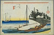
Kuwana-juku
Encyclopedia

53 Stations of the Tokaido
The are the rest areas along the Tōkaidō, which was a coastal route that ran from Nihonbashi in Edo to Sanjō Ōhashi in Kyoto.-Stations of the Tōkaidō:...
of the Tōkaidō
Tokaido (road)
The ' was the most important of the Five Routes of the Edo period, connecting Edo to Kyoto in Japan. Unlike the inland and less heavily travelled Nakasendō, the Tōkaidō travelled along the sea coast of eastern Honshū, hence the route's name....
. It is located in the present-day city of Kuwana
Kuwana, Mie
is a city located in the northern end of Mie Prefecture, Japan. It is known as a major sightseeing city in the prefecture. Located at the mouth of the three rivers dividing Mie and Aichi prefectures, the city has functioned as a regional center of fishing, industry, business, and culture.As of...
, in Mie Prefecture
Mie Prefecture
is a prefecture of Japan which is part of the Kansai regions on Honshū island. The capital is the city of Tsu.- History :Until the Meiji Restoration, Mie prefecture was known as Ise Province and Iga Province....
, Japan
Japan
Japan is an island nation in East Asia. Located in the Pacific Ocean, it lies to the east of the Sea of Japan, China, North Korea, South Korea and Russia, stretching from the Sea of Okhotsk in the north to the East China Sea and Taiwan in the south...
. It was located on the western shores of the Ibi River
Ibi River
The is a tributary of the Kiso River located in Gifu and Mie Prefectures in Japan. Along with the Nagara and Kiso rivers, the Ibi is the third of the Kiso Three Rivers of the Nōbi Plain. It is one of Japan's first-class rivers...
and is considered to be the Eastern most point of the Kansai dialect. It is 28 km from the preceding post station
Shukuba
were post stations during the Edo period in Japan, generally located on one of the Edo Five Routes or one of its sub-routes. They were also called shukueki . These post stations were places where travelers could rest on their journey around the nation...
of Miya-juku
Miya-juku
was the forty-first of the fifty-three stations of the Tōkaidō. It is located in the Atsuta-ku section of the city of Nagoya, in Aichi Prefecture, Japan. It was six km from Narumi-juku, the preceding post station.-History:...
.
History
This post station was located in the castle townCastle town
A castle town is a settlement built adjacent to or surrounding a castle. Castle towns are common in Medieval Europe. Good example include small towns like Alnwick and Arundel, which are still dominated by their castles...
of the Kuwana clan. It is connected to Miya-juku through the Pass of 28 km (七里の渡し Shichiri no Watashi) and served as the entrance for those going towards Ise Shrine
Ise Shrine
is a Shinto shrine dedicated to goddess Amaterasu-ōmikami, located in the city of Ise in Mie prefecture, Japan. Officially known simply as , Ise Jingū is in fact a shrine complex composed of a large number of Shinto shrines centered on two main shrines, and ....
. Some travelers along the road would take ships across the inner Ise Bay
Ise Bay
Ise Bay is a bay located at the mouth of the Kiso River between Mie and Aichi Prefectures in Japan. Ise Bay has an average depth of 19.5 metres and a maximum depth of 30 metres toward the centre. The mouth of the bay is 9 kilometres wide and is connected to the smaller Mikawa Bay by two channels:...
from Miya-juku (located in present-day Nagoya near Atsuta Shrine
Atsuta Shrine
is a Shinto shrine traditionally believed to have been established during the reign of Emperor Keikō located in Atsuta-ku, Nagoya, Aichi Prefecture in Japan. The shrine is familiarly known as Atsuta-Sama or simply as Miya...
) to Kuwana, which reputably made the journey more enjoyable.
During the Edo period
Edo period
The , or , is a division of Japanese history which was ruled by the shoguns of the Tokugawa family, running from 1603 to 1868. The political entity of this period was the Tokugawa shogunate....
, Kuwana was directly on the shores of the river, but after Kansai Railroad built Kuwana Station
Kuwana Station
is a train station in Kuwana, Mie Prefecture, Japan.-Lines:*Central Japan Railway Company **Kansai Main Line*Kintetsu**Nagoya Line*Yōrō Railway**Yōrō LineSangi Railway's Nishi-Kuwana Station is attached to the station.-Layout:...
, the city center was shifted further to the west.
Neighboring post towns
Tōkaidō- Miya-jukuMiya-jukuwas the forty-first of the fifty-three stations of the Tōkaidō. It is located in the Atsuta-ku section of the city of Nagoya, in Aichi Prefecture, Japan. It was six km from Narumi-juku, the preceding post station.-History:...
- Kuwana-juku - Yokkaichi-jukuYokkaichi-jukuwas the forty-third of the fifty-three stations of the Tōkaidō. It is located in the present-day city of Yokkaichi, in Mie Prefecture, Japan. It was 12.8 km from Kuwana-juku, the preceding post town.-History:...
Saya Kaidō
- Saya-juku - Kuwana-juku (ending location)

