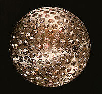
LAGEOS
Encyclopedia

Satellite
In the context of spaceflight, a satellite is an object which has been placed into orbit by human endeavour. Such objects are sometimes called artificial satellites to distinguish them from natural satellites such as the Moon....
s designed to provide an orbiting laser ranging
Satellite laser ranging
In satellite laser ranging a global network of observation stations measure the round trip time of flight of ultrashort pulses of light to satellites equipped with retroreflectors...
benchmark for geodynamical studies of the Earth. Each satellite is a high density passive laser reflector in a very stable Medium Earth orbit
Medium Earth Orbit
Medium Earth orbit , sometimes called intermediate circular orbit , is the region of space around the Earth above low Earth orbit and below geostationary orbit ....
.
Function and operation
The spacecraft are aluminiumAluminium
Aluminium or aluminum is a silvery white member of the boron group of chemical elements. It has the symbol Al, and its atomic number is 13. It is not soluble in water under normal circumstances....
-covered brass
Brass
Brass is an alloy of copper and zinc; the proportions of zinc and copper can be varied to create a range of brasses with varying properties.In comparison, bronze is principally an alloy of copper and tin...
spheres with a diameter of 60 cm and masses of 400 and 411 kg, covered with 426 cube-corner retro-reflectors, giving them the appearance of giant golf ball
Golf ball
A golf ball is a ball designed to be used in the game of golf.Under the Rules of Golf, a golf ball weighs no more than 1.620 oz , has a diameter not less than 1.680 in , and performs within specified velocity, distance, and symmetry limits...
s. They have no onboard sensors or electronics, and are not attitude controlled.
They orbit at an altitude of 5900 kilometres (3,666.1 mi), well above low earth orbit
Low Earth orbit
A low Earth orbit is generally defined as an orbit within the locus extending from the Earth’s surface up to an altitude of 2,000 km...
and well below Geostationary orbit
Geostationary orbit
A geostationary orbit is a geosynchronous orbit directly above the Earth's equator , with a period equal to the Earth's rotational period and an orbital eccentricity of approximately zero. An object in a geostationary orbit appears motionless, at a fixed position in the sky, to ground observers...
at orbital inclinations of 109.8 and 52.6 degrees.
Measurements are made by transmitting pulsed laser beams from Earth ground stations to the satellites. The laser beams then return to Earth after hitting the reflecting surfaces; the travel times are precisely measured, permitting ground stations in different parts of the Earth to measure their separations to better than one inch in thousands of miles.
The LAGEOS satellites make it possible to determine positions of points on the Earth with extremely high accuracy due to the stability of their orbits.
The high mass-to-area ratio and the precise, stable (attitude-independent) geometry of the LAGEOS spacecraft, together with their extremely regular orbits, make these satellites the most precise position references available.
Mission goals
The LAGEOS mission consists of the following key goals:- Provide an accurate measurement of the satellite's position with respect to Earth,
- Determine the planet's shape (geoidGeoidThe geoid is that equipotential surface which would coincide exactly with the mean ocean surface of the Earth, if the oceans were in equilibrium, at rest , and extended through the continents . According to C.F...
) and, - Determine tectonic plate movements associated with continental driftContinental driftContinental drift is the movement of the Earth's continents relative to each other. The hypothesis that continents 'drift' was first put forward by Abraham Ortelius in 1596 and was fully developed by Alfred Wegener in 1912...
.
Ground tracking stations are located in many countries (including the US, Mexico, France, Germany, Poland, Australia, Egypt, China, Peru, Italy, and Japan) and data from these stations is available worldwide to investigators studying crustal dynamics.
There are two LAGEOS spacecraft, LAGEOS-1 launched in 1976, and LAGEOS-2 launched in 1992. , both LAGEOS spacecraft are routinely tracked by the ILRS network..
The satellite (which is predicted to re-enter the atmosphere in 8.4 million years) also contains a plaque showing the arrangement of the Earth's continents in the past, present, and future.
Launch data
- LAGEOS 1, launched 4 May 1976, NSSDCNational Space Science Data CenterThe National Space Science Data Center serves as the permanent archive for NASA space science mission data. "Space science" pertains to astronomy and astrophysics, solar and space plasma physics, and planetary and lunar science...
ID 1976-039A, NORAD number 8820 - LAGEOS 2, deployed 23 October 1992 from STS-52STS-52-Mission parameters:*Mass:**Orbiter landing with payload: **Payload: *Perigee: *Apogee: *Inclination: 28.5°*Period: 90.6 min-Mission highlights:...
, NSSDC ID 1992-070B, NORAD number 22195

