La Fare-en-Champsaur
Encyclopedia
La Fare-en-Champsaur is a commune
in the department of Hautes-Alpes
in the Provence-Alpes-Côte d'Azur
region
in southeastern France
.
opposite Saint-Bonnet
. It is backed by Mount Mouttet in the foothills of the Dévoluy massif. Its geographical position gives it a pleasant climate in summer but colder in winter.
The town extends from the river Drac (at an altitude of 950m downstream from the bridge of Saint-Bonnet
) to the heights of Coste Folle (alt. 2079m). The terrain consists of:
The old town consists of three closely sited hamlets called Les Farelles, La Fare and Le Serre, and is located on the Chaup plain at an altitude of 1100 meters. This is the older part of the village which is exclusively agricultural and very poor.
The lower part of the village, Les Baraques, Les Allards and Bonnette) was developed around the Grenoble
- Gap
road (route nationale 85) on the Route Napoléon
with a hotel, a tourist office, a cafe and several shops including a supermarket. The council has recently been moved from the old town to Les Baraques.
La Fare communicates with Saint-Bonnet, the 'capital' of Champsaur, via the only bridge on the Drac. The two municipalities are complementary: Saint-Bonnet offers a greater range of services and businesses but is off the main road, and La Fare, which is smaller but better placed, acts as a suburb of the town.
to the province of Gap which was then under the political authority of Dauphiné. The bridge was also a crossroads, particularly important when François de Bonne of Lesdiguières, steward of Dauphiné, returned to the town of Saint-Bonnet.
Les Baraques, therefore, was a place where there were food and shelter, and this continues today. The hamlet has never changed its name, but the town hall was recently moved there, and it is now the name of the town ('La Fare') which appears on signs at the entrance to the village.

Communes of France
The commune is the lowest level of administrative division in the French Republic. French communes are roughly equivalent to incorporated municipalities or villages in the United States or Gemeinden in Germany...
in the department of Hautes-Alpes
Hautes-Alpes
Hautes-Alpes is a department in southeastern France named after the Alps mountain range.- History :Hautes-Alpes is one of the original 83 departments created during the French Revolution on 4 March 1790...
in the Provence-Alpes-Côte d'Azur
Provence-Alpes-Côte d'Azur
Provence-Alpes-Côte d'Azur or PACA is one of the 27 regions of France.It is made up of:* the former French province of Provence* the former papal territory of Avignon, known as Comtat Venaissin...
region
Régions of France
France is divided into 27 administrative regions , 22 of which are in Metropolitan France, and five of which are overseas. Corsica is a territorial collectivity , but is considered a region in mainstream usage, and is even shown as such on the INSEE website...
in southeastern France
France
The French Republic , The French Republic , The French Republic , (commonly known as France , is a unitary semi-presidential republic in Western Europe with several overseas territories and islands located on other continents and in the Indian, Pacific, and Atlantic oceans. Metropolitan France...
.
Geography
The commune is located in the western part of Champsaur on the left bank of the river DracDrac River
The Drac is a 130 km long river in southeastern France, left tributary of the Isère. It is formed by the confluence of the Drac Noir and the Drac Blanc, that both rise in the southern part of the Massif des Écrins. It flows through several reservoirs, including the Lac de Monteynard-Avignonet....
opposite Saint-Bonnet
Saint-Bonnet
Saint-Bonnet is a commune in the Charente department in south-estern France.-Population:-External links:* *...
. It is backed by Mount Mouttet in the foothills of the Dévoluy massif. Its geographical position gives it a pleasant climate in summer but colder in winter.
The town extends from the river Drac (at an altitude of 950m downstream from the bridge of Saint-Bonnet
Saint-Bonnet
Saint-Bonnet is a commune in the Charente department in south-estern France.-Population:-External links:* *...
) to the heights of Coste Folle (alt. 2079m). The terrain consists of:
- the edge of the Drac which is now largely constrained by the road;
- the Chaup plain, the ancient area of the glacial valley which provides a plateau for crops and pastures;
- a forest of pinePinePines are trees in the genus Pinus ,in the family Pinaceae. They make up the monotypic subfamily Pinoideae. There are about 115 species of pine, although different authorities accept between 105 and 125 species.-Etymology:...
and larchLarchLarches are conifers in the genus Larix, in the family Pinaceae. Growing from 15 to 50m tall, they are native to much of the cooler temperate northern hemisphere, on lowlands in the north and high on mountains further south...
which is used for its timber; - unusable cliffs and rocky slopes;
- some easily accessible areas high on Mount Mouttet.
The old town consists of three closely sited hamlets called Les Farelles, La Fare and Le Serre, and is located on the Chaup plain at an altitude of 1100 meters. This is the older part of the village which is exclusively agricultural and very poor.
The lower part of the village, Les Baraques, Les Allards and Bonnette) was developed around the Grenoble
Grenoble
Grenoble is a city in southeastern France, at the foot of the French Alps where the river Drac joins the Isère. Located in the Rhône-Alpes region, Grenoble is the capital of the department of Isère...
- Gap
Gap, Hautes-Alpes
Gap is a commune in southeastern France, the capital of the Hautes-Alpes department.-Geography:An Alpine crossroads at the intersection of D994 and Route nationale 85 the Route Napoléon, Gap lies above sea level along the right bank of the Luye River...
road (route nationale 85) on the Route Napoléon
Route Napoléon
Route Napoléon is the route taken by Napoléon in 1815 on his return from Elba. It is now a 325-kilometre section of the Route nationale 85.The route begins at Golfe-Juan, where Napoleon disembarked 1 March 1815, beginning the Hundred Days that ended at Waterloo. The road was inaugurated in 1932; it...
with a hotel, a tourist office, a cafe and several shops including a supermarket. The council has recently been moved from the old town to Les Baraques.
La Fare communicates with Saint-Bonnet, the 'capital' of Champsaur, via the only bridge on the Drac. The two municipalities are complementary: Saint-Bonnet offers a greater range of services and businesses but is off the main road, and La Fare, which is smaller but better placed, acts as a suburb of the town.
History
The hamlet of Les Baraques (or Barraques) was originally a relay stop for stagecoaches (the term 'baraque' describes the stables for horses on the great journeys of the eighteenth and nineteenth centuries.) It was an important stop at the foot of the Col Bayard, on the road joining DauphinéDauphiné
The Dauphiné or Dauphiné Viennois is a former province in southeastern France, whose area roughly corresponded to that of the present departments of :Isère, :Drôme, and :Hautes-Alpes....
to the province of Gap which was then under the political authority of Dauphiné. The bridge was also a crossroads, particularly important when François de Bonne of Lesdiguières, steward of Dauphiné, returned to the town of Saint-Bonnet.
Les Baraques, therefore, was a place where there were food and shelter, and this continues today. The hamlet has never changed its name, but the town hall was recently moved there, and it is now the name of the town ('La Fare') which appears on signs at the entrance to the village.
Demographics
Sights

- The old village and its church and cemetery;
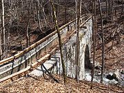
- The aqueduct of the Pont-du-Fossé canal on La Fare stream (nineteenth century);
- The site of Notre-Dame de Bois-Vert, with views of Saint-Bonnet and the Vieux Chaillol massif, and the starting point for walks in a larch forest (alt. 1360 meters, accessible by car). In winter, a waterfall of ice attracts climbers;
- Mount Mouttet and its cliffs, a view on the valley and mountains surrounding the Queyras valley to the east of the Alps (altitude 1800 m., accessible only to experienced walkers);
- Developments in kayakingKayakingKayaking is the use of a kayak for moving across water. Kayaking and canoeing are also known as paddling. Kayaking is distinguished from canoeing by the sitting position of the paddler and the number of blades on the paddle...
and canoeing on the Drac from the Saint-Bonnet bridge to the La Guinguette bridge 5 km downstream;
External links
- Website for the prefecture of Hautes-Alpes, accessed May 9, 2009
- INSEE commune file
- Tourism website for the valley

