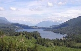
Lake Cavanaugh, Washington
Encyclopedia
Lake Cavanaugh is a census-designated place
(CDP) in Skagit County, Washington
, United States. The population was 167 at the 2010 census. It is included in the Mount Vernon
–Anacortes
, Washington Metropolitan Statistical Area.
Based on per capita income
, Lake Cavanaugh ranks 30th of 522 areas in the state of Washington to be ranked. It is also the highest rank achieved in Skagit County.
According to the United States Census Bureau
, the CDP has a total area of 2.1 square miles (5.5 km²), of which, 0.9 square miles (2.3 km²) of it is land and 1.3 square miles (3.3 km²) of it (59.15%) is water.
There were 58 households out of which 10.3% had children under the age of 18 living with them, 70.7% were married couples living together, and 27.6% were non-families. 25.9% of all households were made up of individuals and 3.4% had someone living alone who was 65 years of age or older. The average household size was 2.10 and the average family size was 2.43.
In the CDP the age distribution of the population shows 9.8% under the age of 18, 5.7% from 18 to 24, 11.5% from 25 to 44, 55.7% from 45 to 64, and 17.2% who were 65 years of age or older. The median age was 54 years. For every 100 females there were 117.9 males. For every 100 females age 18 and over, there were 129.2 males.
The median income for a household in the CDP was $66,250, and the median income for a family was $95,012. Males had a median income of $35,096 versus $0 for females. The per capita income
for the CDP was $32,195. None of the population or families were below the poverty line.
Census-designated place
A census-designated place is a concentration of population identified by the United States Census Bureau for statistical purposes. CDPs are delineated for each decennial census as the statistical counterparts of incorporated places such as cities, towns and villages...
(CDP) in Skagit County, Washington
Skagit County, Washington
Skagit County is a county in the U.S. state of Washington. It is named after the Skagit Indian tribe. As of 2010, the population was 116,901. It is included in the Mount Vernon-Anacortes, Washington, Metropolitan Statistical Area...
, United States. The population was 167 at the 2010 census. It is included in the Mount Vernon
Mount Vernon, Washington
Mount Vernon is a city in Skagit County, Washington, United States. The population was 31,743 at the 2010 census. It is one of two principal cities of and included in the Mount Vernon-Anacortes, Washington Metropolitan Statistical Area. It is the county seat of Skagit County...
–Anacortes
Anacortes, Washington
Anacortes is a city in Skagit County, Washington, United States. The name "Anacortes" is a consolidation of the name Anna Curtis, who was the wife of early Fidalgo Island settler Amos Bowman. Anacortes' population was 15,778 at the time of the 2010 census...
, Washington Metropolitan Statistical Area.
Based on per capita income
Washington locations by per capita income
Washington is the twelfth richest state in the United States of America, with a per capita income of $22,973 and a personal per capita income of $33,332 .-Washington counties ranked by per capita income:...
, Lake Cavanaugh ranks 30th of 522 areas in the state of Washington to be ranked. It is also the highest rank achieved in Skagit County.
Geography
Lake Cavanaugh is located at 48°19′33"N 122°1′13"W (48.325855, -122.020391).According to the United States Census Bureau
United States Census Bureau
The United States Census Bureau is the government agency that is responsible for the United States Census. It also gathers other national demographic and economic data...
, the CDP has a total area of 2.1 square miles (5.5 km²), of which, 0.9 square miles (2.3 km²) of it is land and 1.3 square miles (3.3 km²) of it (59.15%) is water.
Demographics
As of the census of 2000, there were 122 people, 58 households, and 41 families residing in the CDP. The population density was 140.3 people per square mile (54.1/km²). There were 386 housing units at an average density of 443.8/sq mi (171.3/km²). The racial makeup of the CDP was 98.36% White, 0.82% Asian, and 0.82% from two or more races.There were 58 households out of which 10.3% had children under the age of 18 living with them, 70.7% were married couples living together, and 27.6% were non-families. 25.9% of all households were made up of individuals and 3.4% had someone living alone who was 65 years of age or older. The average household size was 2.10 and the average family size was 2.43.
In the CDP the age distribution of the population shows 9.8% under the age of 18, 5.7% from 18 to 24, 11.5% from 25 to 44, 55.7% from 45 to 64, and 17.2% who were 65 years of age or older. The median age was 54 years. For every 100 females there were 117.9 males. For every 100 females age 18 and over, there were 129.2 males.
The median income for a household in the CDP was $66,250, and the median income for a family was $95,012. Males had a median income of $35,096 versus $0 for females. The per capita income
Per capita income
Per capita income or income per person is a measure of mean income within an economic aggregate, such as a country or city. It is calculated by taking a measure of all sources of income in the aggregate and dividing it by the total population...
for the CDP was $32,195. None of the population or families were below the poverty line.

