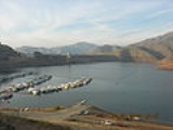
Lake Kaweah
Encyclopedia
Lake Kaweah is a reservoir
near Lemon Cove
in Tulare County, California
. The lake is formed by Terminus Dam
on the Kaweah River
. The river originates in the Sierra Nevada mountains and drains about 560 sq mi (1,450.4 km²) into Lake Kaweah. From Lake Kaweah, the river passes near the city of Visalia
as it flows west into the Tulare Lake
bed. The lake has a capacity of 185000 acre.ft. A project to raise the lake 21 ft (6.4 m) was completed in 2004. The lake now impounds an additional 42000 acre.ft and downstream flood protection to downstream communities and agricultural land has been increased.
From 2004 to 2009, Lake Kaweah was mostly empty due to severe drought
conditions. Most of the Kaweah River valley could be seen and many trees and grasses grew over the original reservoir site. Over the years the natural ecosystem slowly rebounded, while parking lots and boat launches were moved down into the original lake bed. However, heavy snowpack in 2010 filled the lake to capacity, peaking on May 25, 2010 at full pool, requiring outflow of over 1640 cuft/s, while the outflow had not exceeded 100 cuft/s for half a decade. The inflow to the lake was as high as 2000 cuft/s for many days in a row. The lake has since decreased by about 40000 acre.ft.
Reservoir
A reservoir , artificial lake or dam is used to store water.Reservoirs may be created in river valleys by the construction of a dam or may be built by excavation in the ground or by conventional construction techniques such as brickwork or cast concrete.The term reservoir may also be used to...
near Lemon Cove
Lemon Cove, California
Lemon Cove is a census-designated place in Tulare County, California, United States. The population was 308 at the 2010 census, up from 298 at the 2000 census.-Geography and ecology:...
in Tulare County, California
Tulare County, California
Tulare County is a county located in the Central Valley of the U.S. state of California, south of Fresno. Sequoia National Park is located in the county, as are part of Kings Canyon National Park, in its northeast corner , and part of Mount Whitney, on its eastern border...
. The lake is formed by Terminus Dam
Terminus Dam
Terminus Dam is a dam on the Kaweah River, which serves to form Lake Kaweah.The dam provides irrigation and municipal water supply, and as a result, the Kaweah River below the dam is usually regulated for a stable flow year round. The South Fork and the mainstem of the Kaweah both flow into the...
on the Kaweah River
Kaweah River
The Kaweah River in the U.S. state of California flows westward from the foothills of the Sierra Nevada into the Central Valley. It rises in forks in the southern Sierra Nevada inside Sequoia National Park, the longest of which is the Middle Fork, about long...
. The river originates in the Sierra Nevada mountains and drains about 560 sq mi (1,450.4 km²) into Lake Kaweah. From Lake Kaweah, the river passes near the city of Visalia
Visalia, California
Visalia is a Central California city situated in the heart of California’s agricultural San Joaquin Valley, approximately southeast of San Francisco and north of Los Angeles...
as it flows west into the Tulare Lake
Tulare Lake
Tulare Lake, named Laguna de Tache by the Spanish, is a fresh-water dry lake with residual wetlands and marshes in southern San Joaquin Valley, California...
bed. The lake has a capacity of 185000 acre.ft. A project to raise the lake 21 ft (6.4 m) was completed in 2004. The lake now impounds an additional 42000 acre.ft and downstream flood protection to downstream communities and agricultural land has been increased.
From 2004 to 2009, Lake Kaweah was mostly empty due to severe drought
Drought
A drought is an extended period of months or years when a region notes a deficiency in its water supply. Generally, this occurs when a region receives consistently below average precipitation. It can have a substantial impact on the ecosystem and agriculture of the affected region...
conditions. Most of the Kaweah River valley could be seen and many trees and grasses grew over the original reservoir site. Over the years the natural ecosystem slowly rebounded, while parking lots and boat launches were moved down into the original lake bed. However, heavy snowpack in 2010 filled the lake to capacity, peaking on May 25, 2010 at full pool, requiring outflow of over 1640 cuft/s, while the outflow had not exceeded 100 cuft/s for half a decade. The inflow to the lake was as high as 2000 cuft/s for many days in a row. The lake has since decreased by about 40000 acre.ft.

