
Lake Santeetlah, North Carolina
Encyclopedia
Lake Santeetlah is a town in Graham County
, North Carolina
, United States
, six miles (10 km) north of Robbinsville
and within fifteen miles (24 km) of the Great Smoky Mountains National Park
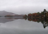
on a peninsula surrounded by Lake Santeetlah—which in turn is largely surrounded by Nantahala National Forest
. The town has more than two hundred residences, many of them second homes owned by permanent residents of Florida
and Georgia
. The town was organized in 1989 as Santeetlah; in 1999, it changed its name to Lake Santeetlah. The full-time population was 67 at the 2000 census.
According to the United States Census Bureau
, the town has a total area of 0.2 square mile (0.517997622 km²), all of it land.
was one of the last sections of the eastern United States to be settled by Europeans. Robbinsville
was not incorporated until 1893, and it had only two hundred residents in 1915. The area known as Santeetlah along the Cheoah River
was sparsely settled, and in any case, the river valley was flooded after Santeetlah Dam
was completed in 1928. In 1939, the U.S. Forest Service purchased from Carolina Aluminum Company the land now occupied by the town of Lake Santeetlah.
The father of Lake Santeetlah was Kenneth S. Keyes, Sr. (1896–1995), a native of Detroit
, who became an extremely successful real estate dealer in Miami
, heading over fifty corporations that operated hotels, office buildings and other realty enterprises in Florida, New York, and Canada. In 1957 he served as president of the National Association of Realtors
.
In 1947, Keyes exchanged with the Forest Service some land he held for the area that is now the town of Lake Santeetlah. For undetermined reasons he called the property "Thunderbird Estates." Apparently Keyes hoped to build a large hotel complex in the area of the community now known as Chalet Village, and that area was graded in preparation for building. Nevertheless, although he hired a Miami architectural firm to draw the plans, Keyes never built, and in 1958, he sold the undeveloped property to another Florida land developer who transferred it again in 1961.
In the early 1960s, a new corporation, Smoky Mountain Resorts, built a lodge and some cabins, and the first landowners began to build on the north shore of the peninsula. The lodge, with its two faux totem poles, became "the heartbeat of Thunderbird Mountain Resort" with activities that included square dancing, bingo, movies, and church services, as well as a place "to gather together when the mail was delivered." Although roads were graded and paved and a water system installed, "Thunderbird Mountain Club Resort," as the development was first called, was "always short of capital." In 1971, Smoky Mountain Resorts sold its interest to W. Bennett Collette, "a dabbler in buying financially distressed properties."
Collette transferred the properties around among his various companies, and by 1973, he had clearly communicated to the residents that he was not interested in operating the water system. The Thunderbird Homeowners Association—later, Thunderbird Property Owners Association—which had been formed in 1969 and incorporated in 1971, began to investigate the possibility of taking over the water system itself, not without disharmony among the members. In 1979, the Insurance Commissioner of Indiana confiscated the assets of Collette's now-defunct Pilgrim Life Insurance Company, and the State of Indiana briefly owned Thunderbird Mountain before selling it to Executive National Life Insurance in 1981.
Relations between Executive National Life Insurance and the Thunderbird property owners "were at best rocky." The insurance company did not repair the water system or provide other services specified by the restrictive covenants, and many property owners stopped paying their fees. The water system grew so unreliable that some property owners dug their own wells. A lawsuit by the insurance company was dismissed by the court, and the company became more amenable to the formation of an incorporated town.
On April 13, 1989, Thunderbird Mountain became the Town of Santeetlah, and in 1991, Executive National transferred the roads and the water system to the town. Through state grants and assessments on the properties (including those of the insurance company), a new water system was created and the roads were repaved. The same year a volunteer fire department and community center was constructed. Ten years later, in 1998, a town hall was dedicated on the Fourth of July.
In 1979, the State of North Carolina had prohibited any new connections to the antiquated water system. Although property sales and home construction did not completely cease—a builder could drill his own well—the completion of the new water system in 1995 occurred simultaneously with a new round of construction. Homes built in the 1990s and first decade of the new century tended to be much grander than the simple cottages of the 1960s. The lodge, which had operated only sporadically during the preceding decades, was recycled into the sales office of an upscale lake-front development called Santeetlah Lakeside, and million-dollar property transfers occurred for the first time. In 2007 the Town announced that tax revenues from escalating property values were accumulating so quickly that it had decided to slightly reduce millage rates.
of 2000, there were 67 people, 38 households, and 25 families residing in the town. The population density
was 332.4 people per square mile (129.3/km²). There were 172 housing units at an average density of 853.3 per square mile (332.0/km²). The racial makeup of the town was 94.03% White, 1.49% African American and 4.48% Native American. Hispanic or Latino of any race were 1.49% of the population.
There were 38 households out of which 5.3% had children under the age of 18 living with them, 65.8% were married couples
living together, and 31.6% were non-families. 31.6% of all households were made up of individuals and 13.2% had someone living alone who was 65 years of age or older. The average household size was 1.76 and the average family size was 2.12.
In the town the population was spread out with 4.5% under the age of 18, 10.4% from 25 to 44, 41.8% from 45 to 64, and 43.3% who were 65 years of age or older. The median age was 61 years. For every 100 females there were 97.1 males. For every 100 females age 18 and over, there were 100.0 males.
The median income for a household in the town was $70,417, and the median income for a family was $83,989. Males had a median income of $50,625 versus $0 for females. The per capita income
for the town was $53,491. There were no families and 13.2% of the population living below the poverty line, including no under eighteens and 9.1% of those over 64.
which surrounds it provide exceptional recreational opportunities. The lake has a variety of fish including smallmouth bass
, largemouth bass
, walleye
, crappie
, bream, and lake trout
. Santeetlah Marina is the only full-service marina on a lake that has 76 miles (122.3 km) of shoreline. There are more than fifty primitive campsites scattered around the lake that include a picnic table and fire ring; they have no water or toilets but also require neither permits nor fees.
There are over 200 miles (321.9 km) of hiking trails in the Cheoah District, and one can hike about eight miles (13 km) from Lake Santeetlah to the Appalachian Trail
. Approximately a mile from the town is Cheoah Point Recreation Area, which has developed swimming, camping, and picnicking facilities as well as a boat ramp.
The nearby Cheoah River
is noted for its Class IV and V whitewater rapids, available for use approximately seventeen days a year depending on the water-release schedule from Santeetlah Dam
.
Lake Santeetlah adjoins a portion of U.S. 129
called the Tail of the Dragon, a road frequently used for recreational purposes by motorcycle and sports car enthusiasts because of its roughly 318 curves in 11 miles (17.7 km).
Graham County, North Carolina
-Demographics:As of the census of 2000, there were 7,993 people, 3,354 households, and 2,411 families residing in the county. The population density was 27 people per square mile . There were 5,084 housing units at an average density of 17 per square mile...
, North Carolina
North Carolina
North Carolina is a state located in the southeastern United States. The state borders South Carolina and Georgia to the south, Tennessee to the west and Virginia to the north. North Carolina contains 100 counties. Its capital is Raleigh, and its largest city is Charlotte...
, United States
United States
The United States of America is a federal constitutional republic comprising fifty states and a federal district...
, six miles (10 km) north of Robbinsville
Robbinsville, North Carolina
Robbinsville is a town in Graham County, North Carolina, United States. The population was 747 at the 2000 census. It is the county seat of Graham County. Robbinsville High School is the only high school in Graham County...
and within fifteen miles (24 km) of the Great Smoky Mountains National Park
Great Smoky Mountains National Park
Great Smoky Mountains National Park is a United States National Park and UNESCO World Heritage Site that straddles the ridgeline of the Great Smoky Mountains, part of the Blue Ridge Mountains, which are a division of the larger Appalachian Mountain chain. The border between Tennessee and North...
on a peninsula surrounded by Lake Santeetlah—which in turn is largely surrounded by Nantahala National Forest
Nantahala National Forest
The Nantahala National Forest, established in 1920, is a national forest located in the American state of North Carolina. The word "Nantahala" is a Cherokee word meaning "Land of the Noonday Sun." The name is appropriate as, in some spots, the sun only reaches the floors of the deep gorges of the...
. The town has more than two hundred residences, many of them second homes owned by permanent residents of Florida
Florida
Florida is a state in the southeastern United States, located on the nation's Atlantic and Gulf coasts. It is bordered to the west by the Gulf of Mexico, to the north by Alabama and Georgia and to the east by the Atlantic Ocean. With a population of 18,801,310 as measured by the 2010 census, it...
and Georgia
Georgia (U.S. state)
Georgia is a state located in the southeastern United States. It was established in 1732, the last of the original Thirteen Colonies. The state is named after King George II of Great Britain. Georgia was the fourth state to ratify the United States Constitution, on January 2, 1788...
. The town was organized in 1989 as Santeetlah; in 1999, it changed its name to Lake Santeetlah. The full-time population was 67 at the 2000 census.
Geography
Lake Santeetlah is located at 35°21′49"N 83°51′52"W (35.363578, -83.864367).According to the United States Census Bureau
United States Census Bureau
The United States Census Bureau is the government agency that is responsible for the United States Census. It also gathers other national demographic and economic data...
, the town has a total area of 0.2 square mile (0.517997622 km²), all of it land.
History
Because of its mountainous terrain, Graham CountyGraham County, North Carolina
-Demographics:As of the census of 2000, there were 7,993 people, 3,354 households, and 2,411 families residing in the county. The population density was 27 people per square mile . There were 5,084 housing units at an average density of 17 per square mile...
was one of the last sections of the eastern United States to be settled by Europeans. Robbinsville
Robbinsville, North Carolina
Robbinsville is a town in Graham County, North Carolina, United States. The population was 747 at the 2000 census. It is the county seat of Graham County. Robbinsville High School is the only high school in Graham County...
was not incorporated until 1893, and it had only two hundred residents in 1915. The area known as Santeetlah along the Cheoah River
Cheoah River
The Cheoah River is a tributary of the Little Tennessee River in North Carolina in the United States.It is located in Graham County in far western North Carolina, near Robbinsville, and is approximately 20 miles in length...
was sparsely settled, and in any case, the river valley was flooded after Santeetlah Dam
Santeetlah Dam
Santeetlah Dam is a hydroelectric development on the Cheoah River in Graham County, North Carolina. The dam together with a pipeline/tunnel facility, and a powerhouse form the Santeetlah Development...
was completed in 1928. In 1939, the U.S. Forest Service purchased from Carolina Aluminum Company the land now occupied by the town of Lake Santeetlah.
The father of Lake Santeetlah was Kenneth S. Keyes, Sr. (1896–1995), a native of Detroit
Detroit, Michigan
Detroit is the major city among the primary cultural, financial, and transportation centers in the Metro Detroit area, a region of 5.2 million people. As the seat of Wayne County, the city of Detroit is the largest city in the U.S. state of Michigan and serves as a major port on the Detroit River...
, who became an extremely successful real estate dealer in Miami
Miami, Florida
Miami is a city located on the Atlantic coast in southeastern Florida and the county seat of Miami-Dade County, the most populous county in Florida and the eighth-most populous county in the United States with a population of 2,500,625...
, heading over fifty corporations that operated hotels, office buildings and other realty enterprises in Florida, New York, and Canada. In 1957 he served as president of the National Association of Realtors
National Association of Realtors
The National Association of Realtors , whose members are known as Realtors, is North America's largest trade association. representing over 1.2 million members , including NAR's institutes, societies, and councils, involved in all aspects of the residential and commercial real estate industries...
.
In 1947, Keyes exchanged with the Forest Service some land he held for the area that is now the town of Lake Santeetlah. For undetermined reasons he called the property "Thunderbird Estates." Apparently Keyes hoped to build a large hotel complex in the area of the community now known as Chalet Village, and that area was graded in preparation for building. Nevertheless, although he hired a Miami architectural firm to draw the plans, Keyes never built, and in 1958, he sold the undeveloped property to another Florida land developer who transferred it again in 1961.
In the early 1960s, a new corporation, Smoky Mountain Resorts, built a lodge and some cabins, and the first landowners began to build on the north shore of the peninsula. The lodge, with its two faux totem poles, became "the heartbeat of Thunderbird Mountain Resort" with activities that included square dancing, bingo, movies, and church services, as well as a place "to gather together when the mail was delivered." Although roads were graded and paved and a water system installed, "Thunderbird Mountain Club Resort," as the development was first called, was "always short of capital." In 1971, Smoky Mountain Resorts sold its interest to W. Bennett Collette, "a dabbler in buying financially distressed properties."
Collette transferred the properties around among his various companies, and by 1973, he had clearly communicated to the residents that he was not interested in operating the water system. The Thunderbird Homeowners Association—later, Thunderbird Property Owners Association—which had been formed in 1969 and incorporated in 1971, began to investigate the possibility of taking over the water system itself, not without disharmony among the members. In 1979, the Insurance Commissioner of Indiana confiscated the assets of Collette's now-defunct Pilgrim Life Insurance Company, and the State of Indiana briefly owned Thunderbird Mountain before selling it to Executive National Life Insurance in 1981.
Relations between Executive National Life Insurance and the Thunderbird property owners "were at best rocky." The insurance company did not repair the water system or provide other services specified by the restrictive covenants, and many property owners stopped paying their fees. The water system grew so unreliable that some property owners dug their own wells. A lawsuit by the insurance company was dismissed by the court, and the company became more amenable to the formation of an incorporated town.
On April 13, 1989, Thunderbird Mountain became the Town of Santeetlah, and in 1991, Executive National transferred the roads and the water system to the town. Through state grants and assessments on the properties (including those of the insurance company), a new water system was created and the roads were repaved. The same year a volunteer fire department and community center was constructed. Ten years later, in 1998, a town hall was dedicated on the Fourth of July.
In 1979, the State of North Carolina had prohibited any new connections to the antiquated water system. Although property sales and home construction did not completely cease—a builder could drill his own well—the completion of the new water system in 1995 occurred simultaneously with a new round of construction. Homes built in the 1990s and first decade of the new century tended to be much grander than the simple cottages of the 1960s. The lodge, which had operated only sporadically during the preceding decades, was recycled into the sales office of an upscale lake-front development called Santeetlah Lakeside, and million-dollar property transfers occurred for the first time. In 2007 the Town announced that tax revenues from escalating property values were accumulating so quickly that it had decided to slightly reduce millage rates.
Demographics
As of the censusCensus
A census is the procedure of systematically acquiring and recording information about the members of a given population. It is a regularly occurring and official count of a particular population. The term is used mostly in connection with national population and housing censuses; other common...
of 2000, there were 67 people, 38 households, and 25 families residing in the town. The population density
Population density
Population density is a measurement of population per unit area or unit volume. It is frequently applied to living organisms, and particularly to humans...
was 332.4 people per square mile (129.3/km²). There were 172 housing units at an average density of 853.3 per square mile (332.0/km²). The racial makeup of the town was 94.03% White, 1.49% African American and 4.48% Native American. Hispanic or Latino of any race were 1.49% of the population.
There were 38 households out of which 5.3% had children under the age of 18 living with them, 65.8% were married couples
Marriage
Marriage is a social union or legal contract between people that creates kinship. It is an institution in which interpersonal relationships, usually intimate and sexual, are acknowledged in a variety of ways, depending on the culture or subculture in which it is found...
living together, and 31.6% were non-families. 31.6% of all households were made up of individuals and 13.2% had someone living alone who was 65 years of age or older. The average household size was 1.76 and the average family size was 2.12.
In the town the population was spread out with 4.5% under the age of 18, 10.4% from 25 to 44, 41.8% from 45 to 64, and 43.3% who were 65 years of age or older. The median age was 61 years. For every 100 females there were 97.1 males. For every 100 females age 18 and over, there were 100.0 males.
The median income for a household in the town was $70,417, and the median income for a family was $83,989. Males had a median income of $50,625 versus $0 for females. The per capita income
Per capita income
Per capita income or income per person is a measure of mean income within an economic aggregate, such as a country or city. It is calculated by taking a measure of all sources of income in the aggregate and dividing it by the total population...
for the town was $53,491. There were no families and 13.2% of the population living below the poverty line, including no under eighteens and 9.1% of those over 64.
Recreational Attractions
Santeetlah Lake and the Cheoah District of the Nantahala National ForestNantahala National Forest
The Nantahala National Forest, established in 1920, is a national forest located in the American state of North Carolina. The word "Nantahala" is a Cherokee word meaning "Land of the Noonday Sun." The name is appropriate as, in some spots, the sun only reaches the floors of the deep gorges of the...
which surrounds it provide exceptional recreational opportunities. The lake has a variety of fish including smallmouth bass
Smallmouth bass
The smallmouth bass is a species of freshwater fish in the sunfish family of the order Perciformes. It is the type species of its genus...
, largemouth bass
Largemouth bass
The largemouth bass is a species of black bass in the sunfish family native to North America . It is also known as widemouth bass, bigmouth, black bass, bucketmouth, Potter's fish, Florida bass, Florida largemouth, green bass, green trout, linesides, Oswego bass, southern largemouth...
, walleye
Walleye
Walleye is a freshwater perciform fish native to most of Canada and to the northern United States. It is a North American close relative of the European pikeperch...
, crappie
Crappie
Crappie is a genus of freshwater fish in the sunfish family of order Perciformes. The type species is P. annularis, the white crappie...
, bream, and lake trout
Lake trout
Lake trout is a freshwater char living mainly in lakes in northern North America. Other names for it include mackinaw, lake char , touladi, togue, and grey trout. In Lake Superior, they can also be variously known as siscowet, paperbellies and leans...
. Santeetlah Marina is the only full-service marina on a lake that has 76 miles (122.3 km) of shoreline. There are more than fifty primitive campsites scattered around the lake that include a picnic table and fire ring; they have no water or toilets but also require neither permits nor fees.
There are over 200 miles (321.9 km) of hiking trails in the Cheoah District, and one can hike about eight miles (13 km) from Lake Santeetlah to the Appalachian Trail
Appalachian Trail
The Appalachian National Scenic Trail, generally known as the Appalachian Trail or simply the AT, is a marked hiking trail in the eastern United States extending between Springer Mountain in Georgia and Mount Katahdin in Maine. It is approximately long...
. Approximately a mile from the town is Cheoah Point Recreation Area, which has developed swimming, camping, and picnicking facilities as well as a boat ramp.
The nearby Cheoah River
Cheoah River
The Cheoah River is a tributary of the Little Tennessee River in North Carolina in the United States.It is located in Graham County in far western North Carolina, near Robbinsville, and is approximately 20 miles in length...
is noted for its Class IV and V whitewater rapids, available for use approximately seventeen days a year depending on the water-release schedule from Santeetlah Dam
Santeetlah Dam
Santeetlah Dam is a hydroelectric development on the Cheoah River in Graham County, North Carolina. The dam together with a pipeline/tunnel facility, and a powerhouse form the Santeetlah Development...
.
Lake Santeetlah adjoins a portion of U.S. 129
U.S. Route 129
U.S. Route 129 is an offshoot route of U.S. Route 29, which it intersects near Athens, Georgia. US 129 currently runs for 582 miles from Knoxville, Tennessee, to Chiefland, Florida, at U.S. Route 19 and U.S. Route 98. It passes through the states of Tennessee, North Carolina, Georgia and Florida...
called the Tail of the Dragon, a road frequently used for recreational purposes by motorcycle and sports car enthusiasts because of its roughly 318 curves in 11 miles (17.7 km).