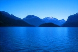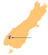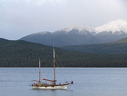
Lake Te Anau
Encyclopedia

South Island
The South Island is the larger of the two major islands of New Zealand, the other being the more populous North Island. It is bordered to the north by Cook Strait, to the west by the Tasman Sea, to the south and east by the Pacific Ocean...
of New Zealand
New Zealand
New Zealand is an island country in the south-western Pacific Ocean comprising two main landmasses and numerous smaller islands. The country is situated some east of Australia across the Tasman Sea, and roughly south of the Pacific island nations of New Caledonia, Fiji, and Tonga...
. Its name was originally Te Ana-au, Maori
Maori language
Māori or te reo Māori , commonly te reo , is the language of the indigenous population of New Zealand, the Māori. It has the status of an official language in New Zealand...
for 'The cave of swirling water'. The lake
Lake
A lake is a body of relatively still fresh or salt water of considerable size, localized in a basin, that is surrounded by land. Lakes are inland and not part of the ocean and therefore are distinct from lagoons, and are larger and deeper than ponds. Lakes can be contrasted with rivers or streams,...
covers an area of 344 km², making it the second-largest lake by surface area in New Zealand (after Lake Taupo
Lake Taupo
Lake Taupo is a lake situated in the North Island of New Zealand. With a surface area of , it is the largest lake by surface area in New Zealand, and the second largest freshwater lake by surface area in geopolitical Oceania after Lake Murray ....
) and the largest in the South Island. Lake Te Anau is however the largest lake in Australasia by fresh water volume.
The main body of the lake runs north-south, and is 65 km in length. Three large fiords form arms to the lake on its western flank: North Fiord, Middle Fiord and South Fiord. These are the only inland Fiords that New Zealand has, the other 14 are out on the coast. Several small islands lie in the entrance to Middle Fiord, which forks partway along its length into northwest and southwest arms. The lake lies at an altitude of 210 m, and since its maximum depth is 417 m much of its bed lies below sea level.
Several rivers feed the lake, of which the most important is the Eglinton River
Eglinton River
The Eglinton River is located in the region of Southland in the southwest of New Zealand. It flows through Fiordland National Park for 50 kilometres...
, which joins the lake from the east, opposite the entrance to North Fiord. The outflow is the Waiau River
Waiau River, Southland
Waiau River is the largest river in the Southland Region of New Zealand. It is the outflow of Lake Te Anau, flowing from it into Lake Manapouri 10 kilometres to the south, and from there flows south for 70 kilometres before reaching the Foveaux Strait eight kilometres south of Tuatapere...
, which flows south for several kilometres into Lake Manapouri
Lake Manapouri
Lake Manapouri is a lake in the South Island of New Zealand. Its name is Maori for "sorrowful heart", though this name is misapplied due to an early cartographical error...
. The town of Te Anau
Te Anau
Te Anau is a town in the South Island of New Zealand. It is on the eastern shore of Lake Te Anau in Fiordland. Lake Te Anau is the largest lake in the South Island and second only within New Zealand to Lake Taupo. The 2001 census recorded the town's population as 1,857...
lies at the south-eastern corner of the lake, close to the outflow.
Most of the lake is within Fiordland National Park
Fiordland National Park
Fiordland National Park occupies the southwest corner of the South Island of New Zealand. It is the largest of the 14 national parks in New Zealand, with an area of 12,500 km², and a major part of the Te Wahipounamu World Heritage site...
and the Te Wahipounamu
Te Wahipounamu
Te Wāhipounamu is a World Heritage site in the south west corner of the South Island of New Zealand.Inscribed on the World Heritage List in 1990 and covering 26,000 km², the site incorporates several National Parks:...
World Heritage site
World Heritage Site
A UNESCO World Heritage Site is a place that is listed by the UNESCO as of special cultural or physical significance...
. Other than the Te Anau township, the only human habitation close to the lake is the farming settlement of Te Anau Downs, close to the mouth of the Eglinton River. Between these two settlements the land is rolling hill country, but elsewhere the land is mountainous, especially along its western shore, where the Kepler and Murchison Mountains rise 1,400 m above the surface of the lake.

New Zealand Great Walks
The New Zealand Great Walks are a set of popular tramping tracks. They are New Zealand's premier tracks, through areas of some of the best scenery in the country...
start at the lake. The Milford Track
Milford Track
The Milford Track is a widely known tramping route in New Zealand – located amidst mountains and temperate rain forest in Fiordland National Park in the southwest of the South Island....
starts at the northern tip of the lake and the Kepler Track
Kepler Track
The Kepler Track is a circular tramping track which travels through some of the spectacular scenery on the South Island of New Zealand. The track passes through many landscapes of the Fiordland National Park ranging from rocky mountain ridges to tall mossy forests, from lake shores to deep gorges....
starts and ends at the south tip of the lake at the Waiau River.
Flora and fauna
Numerous species of wildlife and vegetation are found in the watershed of Lake Te Anau. Vegetative understory includes numerous fern species including the Crown Fern, Blechnum discolorBlechnum discolor
Blechnum discolor is a species of fern in the family Blechnaceae. This species is endemic to New Zealand. As noted by C. Michael Hogan, this species is found in a number of forest communities in diverse locations within New Zealand, and is sometimes a dominant understory component.Spores are...
.
Several species of endangered birds live around the shores of Lake Te Anau, notably the Takahē
Takahe
The Takahē or South Island Takahē, Porphyrio hochstetteri is a flightless bird indigenous to New Zealand and belonging to the rail family. It was thought to be extinct after the last four known specimens were taken in 1898...
(Notornis hochstetteri). An area between the Middle and South Fiords called the Murchison Mountains is a sanctuary set aside for these birds. The western shore of the lake also features the Te Ana-au Caves
Te Ana-au Caves
The Te Ana-au caves are a culturally and ecologically important system of limestone caves on the western shore of Lake Te Anau, in the southwest of New Zealand. It was discovered in 1948 by Lawson Burrows, who found the upper entry after three years of searching, following clues in old Māori legends...
, from which the lake derives its name.

