
Lane County, Kansas
Encyclopedia
Lane County is a county located in the U.S. state
of Kansas
. As of the 2010 census, the county population was 1,750. The county seat
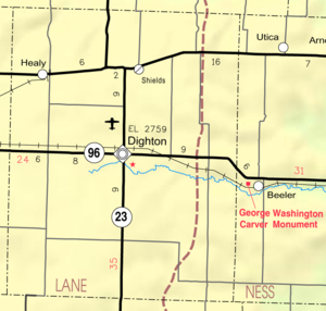
is Dighton
, the only city in the county. Lane County was named after James H. Lane
who was a leader of the Jayhawker
abolitionist movement and served as one of the first U.S. Senators from Kansas.
, county.
 As of the census
of 2000, there were 2,155 people, 910 households, and 613 families residing in the county. The population density
was 3 people per square mile (1/km²). There were 1,065 housing units at an average density of 2 per square mile (1/km²). The racial makeup of the county was 97.73% White
, 0.05% Native American
, 0.09% Asian
, 0.05% Pacific Islander
, 0.51% from other races
, and 1.58% from two or more races. 1.44% of the population were Hispanic
or Latino
of any race.
There were 910 households out of which 29.50% had children under the age of 18 living with them, 59.10% were married couples
living together, 5.10% had a female householder with no husband present, and 32.60% were non-families. 30.30% of all households were made up of individuals and 16.50% had someone living alone who was 65 years of age or older. The average household size was 2.34 and the average family size was 2.91.
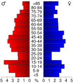
In the county the population was spread out with 25.40% under the age of 18, 5.40% from 18 to 24, 24.60% from 25 to 44, 24.10% from 45 to 64, and 20.50% who were 65 years of age or older. The median age was 42 years. For every 100 females there were 100.30 males. For every 100 females age 18 and over, there were 97.70 males.
The median income for a household in the county was $36,047, and the median income for a family was $41,892. Males had a median income of $29,429 versus $20,446 for females. The per capita income
for the county was $18,606. About 5.40% of families and 8.20% of the population were below the poverty line, including 11.40% of those under age 18 and 7.60% of those age 65 or over.
. None of the cities within the county are considered governmentally independent, and all figures for the townships include those of the cities. In the following table, the population center is the largest city (or cities) included in that township's population total, if it is of a significant size.
State
County level data
Maps
U.S. state
A U.S. state is any one of the 50 federated states of the United States of America that share sovereignty with the federal government. Because of this shared sovereignty, an American is a citizen both of the federal entity and of his or her state of domicile. Four states use the official title of...
of Kansas
Kansas
Kansas is a US state located in the Midwestern United States. It is named after the Kansas River which flows through it, which in turn was named after the Kansa Native American tribe, which inhabited the area. The tribe's name is often said to mean "people of the wind" or "people of the south...
. As of the 2010 census, the county population was 1,750. The county seat
County seat
A county seat is an administrative center, or seat of government, for a county or civil parish. The term is primarily used in the United States....
is Dighton
Dighton, Kansas
Dighton is a city in and the county seat of Lane County, Kansas, United States. As of the 2010 census, the city population was 1,038.-19th century:...
, the only city in the county. Lane County was named after James H. Lane
James H. Lane (Senator)
James Henry Lane also known as Jim Lane was a partisan during the Bleeding Kansas period that immediately preceded the American Civil War. During the war, Lane served as a United States Senator and as a general who fought for the Union...
who was a leader of the Jayhawker
Jayhawker
Jayhawkers is a term that came to prominence just before the American Civil War in Bleeding Kansas, where it was adopted by militant bands affiliated with the free-state cause. These bands, known as "Jayhawkers", were guerrilla fighters who often clashed with pro-slavery groups from Missouri known...
abolitionist movement and served as one of the first U.S. Senators from Kansas.
Law and government
Although the Kansas Constitution was amended in 1986 to allow the sale of alcoholic liquor by the individual drink with the approval of voters, Lane County has remained a prohibition, or "dry"Dry county
A dry county is a county in the United States whose government forbids the sale of alcoholic beverages. Some prohibit off-premises sale, some prohibit on-premises sale, and some prohibit both. Hundreds of dry counties exist across the United States, almost all of them in the South...
, county.
Geography
According to the 2000 census, the county has a total area of 717.43 square miles (1,858.1 km²), of which 717.22 square miles (1,857.6 km²) (or 99.97%) is land and 0.21 square mile (0.5438975031 km²) (or 0.03%) is water.Adjacent counties
- Gove CountyGove County, KansasGove County is a county located in Northwest Kansas, in the Central United States. As of the 2010 census, the county population was 2,695...
(north) - Ness CountyNess County, KansasNess County is a county located in the U.S. state of Kansas. As of the 2010 census, the county population was 3,107. The largest city and county seat is Ness City. Ness County was named for Corporal Noah V. Ness of the 7th Kansas Cavalry...
(east) - Finney CountyFinney County, KansasFinney County is a county located in Southwest Kansas, in the Central United States. As of the 2010 census, the county population was 36,776. Its county seat and most populous city is Garden City...
(south) - Scott CountyScott County, KansasScott County is a county located in the U.S. state of Kansas. As of the 2010 census, the county population was 4,936...
(west)
Demographics
Census
A census is the procedure of systematically acquiring and recording information about the members of a given population. It is a regularly occurring and official count of a particular population. The term is used mostly in connection with national population and housing censuses; other common...
of 2000, there were 2,155 people, 910 households, and 613 families residing in the county. The population density
Population density
Population density is a measurement of population per unit area or unit volume. It is frequently applied to living organisms, and particularly to humans...
was 3 people per square mile (1/km²). There were 1,065 housing units at an average density of 2 per square mile (1/km²). The racial makeup of the county was 97.73% White
Race (United States Census)
Race and ethnicity in the United States Census, as defined by the Federal Office of Management and Budget and the United States Census Bureau, are self-identification data items in which residents choose the race or races with which they most closely identify, and indicate whether or not they are...
, 0.05% Native American
Race (United States Census)
Race and ethnicity in the United States Census, as defined by the Federal Office of Management and Budget and the United States Census Bureau, are self-identification data items in which residents choose the race or races with which they most closely identify, and indicate whether or not they are...
, 0.09% Asian
Race (United States Census)
Race and ethnicity in the United States Census, as defined by the Federal Office of Management and Budget and the United States Census Bureau, are self-identification data items in which residents choose the race or races with which they most closely identify, and indicate whether or not they are...
, 0.05% Pacific Islander
Race (United States Census)
Race and ethnicity in the United States Census, as defined by the Federal Office of Management and Budget and the United States Census Bureau, are self-identification data items in which residents choose the race or races with which they most closely identify, and indicate whether or not they are...
, 0.51% from other races
Race (United States Census)
Race and ethnicity in the United States Census, as defined by the Federal Office of Management and Budget and the United States Census Bureau, are self-identification data items in which residents choose the race or races with which they most closely identify, and indicate whether or not they are...
, and 1.58% from two or more races. 1.44% of the population were Hispanic
Race (United States Census)
Race and ethnicity in the United States Census, as defined by the Federal Office of Management and Budget and the United States Census Bureau, are self-identification data items in which residents choose the race or races with which they most closely identify, and indicate whether or not they are...
or Latino
Race (United States Census)
Race and ethnicity in the United States Census, as defined by the Federal Office of Management and Budget and the United States Census Bureau, are self-identification data items in which residents choose the race or races with which they most closely identify, and indicate whether or not they are...
of any race.
There were 910 households out of which 29.50% had children under the age of 18 living with them, 59.10% were married couples
Marriage
Marriage is a social union or legal contract between people that creates kinship. It is an institution in which interpersonal relationships, usually intimate and sexual, are acknowledged in a variety of ways, depending on the culture or subculture in which it is found...
living together, 5.10% had a female householder with no husband present, and 32.60% were non-families. 30.30% of all households were made up of individuals and 16.50% had someone living alone who was 65 years of age or older. The average household size was 2.34 and the average family size was 2.91.
In the county the population was spread out with 25.40% under the age of 18, 5.40% from 18 to 24, 24.60% from 25 to 44, 24.10% from 45 to 64, and 20.50% who were 65 years of age or older. The median age was 42 years. For every 100 females there were 100.30 males. For every 100 females age 18 and over, there were 97.70 males.
The median income for a household in the county was $36,047, and the median income for a family was $41,892. Males had a median income of $29,429 versus $20,446 for females. The per capita income
Per capita income
Per capita income or income per person is a measure of mean income within an economic aggregate, such as a country or city. It is calculated by taking a measure of all sources of income in the aggregate and dividing it by the total population...
for the county was $18,606. About 5.40% of families and 8.20% of the population were below the poverty line, including 11.40% of those under age 18 and 7.60% of those age 65 or over.
Incorporated cities
Name and population (2004 estimate):- DightonDighton, KansasDighton is a city in and the county seat of Lane County, Kansas, United States. As of the 2010 census, the city population was 1,038.-19th century:...
, 1,138 (county seat)
Townships
Lane County is divided into five townshipsCivil township
A civil township is a widely used unit of local government in the United States, subordinate to, and geographic divisions of, a county. Specific responsibilities and the degree of autonomy vary based on each state. Civil townships are distinct from survey townships, but in states that have both,...
. None of the cities within the county are considered governmentally independent, and all figures for the townships include those of the cities. In the following table, the population center is the largest city (or cities) included in that township's population total, if it is of a significant size.
| Township | FIPS | Population center |
Population | Population density /km² (/sq mi) |
Land area km² (sq mi) | Water area km² (sq mi) | Water % | Geographic coordinates |
|---|---|---|---|---|---|---|---|---|
| Alamota | 00775 | 108 | 0 (1) | 414 (160) | 0 (0) | 0 % | 38°24′55"N 100°19′43"W | |
| Cheyenne | 13050 | 336 | 1 (4) | 245 (94) | 0 (0) | 0 % | 38°36′21"N 100°37′22"W | |
| Dighton | 18075 | 1,573 | 2 (5) | 785 (303) | 0 (0) | 0.01% | 38°27′23"N 100°30′11"W | |
| White Rock | 77950 | 26 | 0 (0) | 207 (80) | 0 (0) | 0.02% | 38°37′49"N 100°19′55"W | |
| Wilson | 79725 | 112 | 1 (1) | 206 (80) | 0 (0) | 0.20% | 38°36′47"N 100°28′12"W |
Education
Unified school districts
Further reading
County- Early Lane County History: 12,000 B.C. - A.D. 1884; Ellen May Stanley.
- Early Lane County Development; Ellen May Stanley.
- Golden Age, Great Depression, and Dust Bowl; Ellen May Stanley.
State
- History of the State of Kansas; William G. Cutler; A.T. Andreas Publisher; 1883. (Online HTML eBook)
- Kansas : A Cyclopedia of State History, Embracing Events, Institutions, Industries, Counties, Cities, Towns, Prominent Persons, Etc; 3 Volumes; Frank W. Blackmar; Standard Publishing Co; 944 / 955 / 824 pages; 1912. (Volume1 - Download 54MB PDF eBook),(Volume2 - Download 53MB PDF eBook), (Volume3 - Download 33MB PDF eBook)
External links
General county informationCounty level data
Maps
- Lane County Map, KDOT
- Kansas Highway Map, KDOT
- Kansas Railroad Map, KDOT
- Kansas School District Boundary Map, KSDE