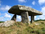
Lanyon Quoit
Encyclopedia

Dolmen
A dolmen—also known as a portal tomb, portal grave, dolmain , cromlech , anta , Hünengrab/Hünenbett , Adamra , Ispun , Hunebed , dös , goindol or quoit—is a type of single-chamber megalithic tomb, usually consisting of...
in Cornwall
Cornwall
Cornwall is a unitary authority and ceremonial county of England, within the United Kingdom. It is bordered to the north and west by the Celtic Sea, to the south by the English Channel, and to the east by the county of Devon, over the River Tamar. Cornwall has a population of , and covers an area of...
, 2 miles southeast of Morvah. It stands next to the road leading from Madron
Madron
Madron is a civil parish and village in west Cornwall, United Kingdom. It is a large rural parish on the Penwith peninsula north of Penzance.Madron village is situated approximately two miles northwest of Penzance town centre....
to Morvah
Morvah
Morvah is a civil parish and village on the Penwith peninsula in west Cornwall, United Kingdom. The village is situated approximately eight miles west-southwest of St Ives and 5½ miles north-west of Penzance....
. In the 18th century, the structure was tall enough for a person on horse back to stand under. The capstone rested at 7 feet high with dimensions of 9 feet by 17.5 feet weighing 13.5 tons. The monument is thought to be a burial chamber; perhaps a mausoleum
Mausoleum
A mausoleum is an external free-standing building constructed as a monument enclosing the interment space or burial chamber of a deceased person or persons. A monument without the interment is a cenotaph. A mausoleum may be considered a type of tomb or the tomb may be considered to be within the...
.
On 19 October, 1815, Lanyon Quoit was torn down by a storm. Nine years later enough money was raised by local inhabitants to re-erect the structure. During the storm one of the uprights was broken in half. Thus, there are only three uprights today and the structure does not stand as high as it once did.
Before the collapse of the structure, it was said to be aligned with the cardinal directions (north, south, east, and west). This gives historians and archaeologists reason to believe that the structure was used for ritual activity.
The chamber lies at the north end of a long barrow 90 ft long and 40 ft wide.

