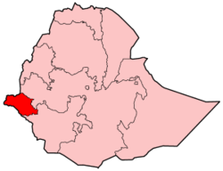
Lare (woreda)
Encyclopedia

Woreda
Woreda is an administrative division of Ethiopia , equivalent to a district . Woredas are composed of a number of Kebele, or neighborhood associations, which are the smallest unit of local government in Ethiopia...
s in the Gambela Region
Gambela Region
Gambela is one of the nine ethnic divisions of Ethiopia. Previously known as "Region 12", its capital is Gambela. Lying between the Baro and Akobo Rivers, the western part of Gambela includes the Baro salient....
of Ethiopia
Ethiopia
Ethiopia , officially known as the Federal Democratic Republic of Ethiopia, is a country located in the Horn of Africa. It is the second-most populous nation in Africa, with over 82 million inhabitants, and the tenth-largest by area, occupying 1,100,000 km2...
. Part of the Nuer Zone, Lare is bordered on the south and east by the Anuak Zone, on the west by the Baro River
Baro River
The Baro River is a river in southwestern Ethiopia, which defines part of Ethiopia's border with South Sudan. From its source in the Ethiopian Highlands it flows west for to join the Pibor River...
which separates it from Jikawo
Jikawo
Jikawo is one of the 12 woredas in the Gambela Region of Ethiopia. Part of the Nuer Zone, Jikawo is bordered on the south by the Anuak Zone, on the west by the Alwero River which separates it from Wentawa, on the north by the Baro River which separates it from Sudan, and on the east by Lare...
, and on the north by the Jikawo River
Jikawo River
Jikawo River is a river of southwestern Ethiopia. It is a tributary of the Baro River, which it joins at latitude and longitude .The river rises in Ethiopia, but in its lower course forms the border with South Sudan.- References :...
which separates it from South Sudan
South Sudan
South Sudan , officially the Republic of South Sudan, is a landlocked country located in the Sahel region of northeastern Africa. It is also part of the North Africa UN sub-region. Its current capital is Juba, which is also its largest city; the capital city is planned to be moved to the more...
. Towns in Jikawo include Kowerneng.
The terrain in Lare consists of marshes and grasslands; elevations range from 300 to 400 meters above sea level. A notable landmark is Gambela National Park
Gambela National Park
Gambela National Park is a proposed National Park, but the steps needed to fully protect it by the government of Ethiopia have not been completed as of 2002...
, which occupies part of the area south of the Baro.
At some point between 2001 and 2007, the eastern kebele
Kebele
A kebele is the smallest administrative unit of Ethiopia similar to ward, a neighbourhood or a localized and delimited group of people...
s of Jikawo were split off to create Lare.
Based on the 2007 Census conducted by the Central Statistical Agency
Central Statistical Agency (Ethiopia)
The Central Statistical Agency is an agency of the government of Ethiopia designated to provide all surveys and censuses for that country used to monitor economic and social growth, as well as to act as an official training center in that field. It is part of the Ethiopian Ministry of Finance and...
of Ethiopia (CSA), this woreda has a total population of 31,406, of whom 16,145 are men and 15,261 women; with an area of 685.17 square kilometers, Lare has a population density of 45.84, which is greater than the Zone average of 23.79 persons per square kilometer. While 6,549 or 20.85% are urban inhabitants, a further 156 or 0.50% are pastoralists. A total of 5,432 households were counted in this woreda, which results in an average of 5.8 persons to a household, and 5,217 housing units.

