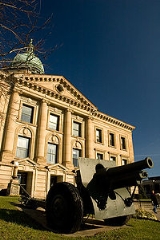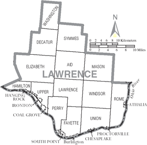
Lawrence County, Ohio
Encyclopedia
As of the census
of 2000, there were 62,319 people, 24,732 households, and 17,807 families residing in the county. The population density
was 137 people per square mile (53/km²). There were 27,189 housing units at an average density of 60 per square mile (23/km²). The racial makeup of the county was 96.55% White
, 2.09% Black
or African American
, 0.18% Native American
, 0.19% Asian
, 0.01% Pacific Islander
, 0.11% from other races
, and 0.88% from two or more races. 0.57% of the population were Hispanic
or Latino
of any race.
There were 24,732 households out of which 32.00% had children under the age of 18 living with them, 56.00% were married couples
living together, 11.90% had a female householder with no husband present, and 28.00% were non-families. 24.90% of all households were made up of individuals and 11.20% had someone living alone who was 65 years of age or older. The average household size was 2.49 and the average family size was 2.96.
In the county, the population was spread out with 24.50% under the age of 18, 8.60% from 18 to 24, 28.00% from 25 to 44, 24.50% from 45 to 64, and 14.40% who were 65 years of age or older. The median age was 38 years. For every 100 females there were 92.20 males. For every 100 females age 18 and over, there were 88.40 males.
The median income for a household in the county was $29,127, and the median income for a family was $35,308. Males had a median income of $30,622 versus $20,961 for females. The per capita income
for the county was $14,678. About 15.10% of families and 18.90% of the population were below the poverty line, including 27.30% of those under age 18 and 12.90% of those age 65 or over.

Census
A census is the procedure of systematically acquiring and recording information about the members of a given population. It is a regularly occurring and official count of a particular population. The term is used mostly in connection with national population and housing censuses; other common...
of 2000, there were 62,319 people, 24,732 households, and 17,807 families residing in the county. The population density
Population density
Population density is a measurement of population per unit area or unit volume. It is frequently applied to living organisms, and particularly to humans...
was 137 people per square mile (53/km²). There were 27,189 housing units at an average density of 60 per square mile (23/km²). The racial makeup of the county was 96.55% White
Race (United States Census)
Race and ethnicity in the United States Census, as defined by the Federal Office of Management and Budget and the United States Census Bureau, are self-identification data items in which residents choose the race or races with which they most closely identify, and indicate whether or not they are...
, 2.09% Black
Race (United States Census)
Race and ethnicity in the United States Census, as defined by the Federal Office of Management and Budget and the United States Census Bureau, are self-identification data items in which residents choose the race or races with which they most closely identify, and indicate whether or not they are...
or African American
Race (United States Census)
Race and ethnicity in the United States Census, as defined by the Federal Office of Management and Budget and the United States Census Bureau, are self-identification data items in which residents choose the race or races with which they most closely identify, and indicate whether or not they are...
, 0.18% Native American
Race (United States Census)
Race and ethnicity in the United States Census, as defined by the Federal Office of Management and Budget and the United States Census Bureau, are self-identification data items in which residents choose the race or races with which they most closely identify, and indicate whether or not they are...
, 0.19% Asian
Race (United States Census)
Race and ethnicity in the United States Census, as defined by the Federal Office of Management and Budget and the United States Census Bureau, are self-identification data items in which residents choose the race or races with which they most closely identify, and indicate whether or not they are...
, 0.01% Pacific Islander
Race (United States Census)
Race and ethnicity in the United States Census, as defined by the Federal Office of Management and Budget and the United States Census Bureau, are self-identification data items in which residents choose the race or races with which they most closely identify, and indicate whether or not they are...
, 0.11% from other races
Race (United States Census)
Race and ethnicity in the United States Census, as defined by the Federal Office of Management and Budget and the United States Census Bureau, are self-identification data items in which residents choose the race or races with which they most closely identify, and indicate whether or not they are...
, and 0.88% from two or more races. 0.57% of the population were Hispanic
Race (United States Census)
Race and ethnicity in the United States Census, as defined by the Federal Office of Management and Budget and the United States Census Bureau, are self-identification data items in which residents choose the race or races with which they most closely identify, and indicate whether or not they are...
or Latino
Race (United States Census)
Race and ethnicity in the United States Census, as defined by the Federal Office of Management and Budget and the United States Census Bureau, are self-identification data items in which residents choose the race or races with which they most closely identify, and indicate whether or not they are...
of any race.
There were 24,732 households out of which 32.00% had children under the age of 18 living with them, 56.00% were married couples
Marriage
Marriage is a social union or legal contract between people that creates kinship. It is an institution in which interpersonal relationships, usually intimate and sexual, are acknowledged in a variety of ways, depending on the culture or subculture in which it is found...
living together, 11.90% had a female householder with no husband present, and 28.00% were non-families. 24.90% of all households were made up of individuals and 11.20% had someone living alone who was 65 years of age or older. The average household size was 2.49 and the average family size was 2.96.
In the county, the population was spread out with 24.50% under the age of 18, 8.60% from 18 to 24, 28.00% from 25 to 44, 24.50% from 45 to 64, and 14.40% who were 65 years of age or older. The median age was 38 years. For every 100 females there were 92.20 males. For every 100 females age 18 and over, there were 88.40 males.
The median income for a household in the county was $29,127, and the median income for a family was $35,308. Males had a median income of $30,622 versus $20,961 for females. The per capita income
Per capita income
Per capita income or income per person is a measure of mean income within an economic aggregate, such as a country or city. It is calculated by taking a measure of all sources of income in the aggregate and dividing it by the total population...
for the county was $14,678. About 15.10% of families and 18.90% of the population were below the poverty line, including 27.30% of those under age 18 and 12.90% of those age 65 or over.
Communities

Villages
|
Hanging Rock, Ohio Hanging Rock is a village in Lawrence County, Ohio, United States, along the Ohio River. The population was 279 at the 2000 census. It is regularly labeled a speed trap as the state auditor reported $109,186 in mayor's court receipts in 2000 compared with $3,106 in property taxes.Hanging Rock is a... Proctorville, Ohio Proctorville is a village in Lawrence County, Ohio, United States, along the Ohio River. The population was 620 at the 2000 census. The East End Bridge connects Proctorville to Huntington, West Virginia across the Ohio River.... South Point, Ohio South Point is a village in Lawrence County, Ohio, United States, along the Ohio River. The population was 3,742 at the 2000 census.South Point is a part of the Huntington-Ashland, WV-KY-OH, Metropolitan Statistical Area . As of the 2000 census, the MSA had a population of 288,649.The village mayor... |
Townships
|
Hamilton Township, Lawrence County, Ohio Hamilton Township is one of the fourteen townships of Lawrence County, Ohio, United States. The 2000 census found 1,817 people in the township, 792 of whom lived in the unincorporated portions of the township.-Geography:... Lawrence Township, Lawrence County, Ohio Lawrence Township is one of the fourteen townships of Lawrence County, Ohio, United States. The 2000 census found 2,574 people in the township.-Geography:Located in the central part of the county, it borders the following townships:*Aid Township - north... Mason Township, Lawrence County, Ohio Mason Township is one of the fourteen townships of Lawrence County, Ohio, United States. The 2000 census found 1,095 people in the township.-Geography:Located in the northeastern part of the county, it borders the following townships:... Perry Township, Lawrence County, Ohio Perry Township is one of the fourteen townships of Lawrence County, Ohio, United States. The 2000 census found 6,813 people in the township, 5,476 of whom lived in the unincorporated portions of the township.-Geography:... |
Rome Township, Lawrence County, Ohio Rome Township is one of the fourteen townships of Lawrence County, Ohio, United States. The 2000 census found 8,694 people in the township, 8,366 of whom lived in the unincorporated portions of the township.-Geography:... Symmes Township, Lawrence County, Ohio Symmes Township is one of the fourteen townships of Lawrence County, Ohio, United States. The 2000 census found 470 people in the township.-Geography:Located in the northern part of the county, it borders the following townships:... Union Township, Lawrence County, Ohio Union Township is one of the fourteen townships of Lawrence County, Ohio, United States. The 2000 census found 9,002 people in the township, 7,540 of whom lived in the unincorporated portions of the township.-Geography:... |
Upper Township, Lawrence County, Ohio Upper Township is one of the fourteen townships of Lawrence County, Ohio, United States. The 2000 census found 15,648 people in the township, 3,170 of whom lived in the unincorporated portions of the township.-Geography:... Washington Township, Lawrence County, Ohio Washington Township is one of the fourteen townships of Lawrence County, Ohio, United States. The 2000 census found 250 people in the township.-Geography:Located in the far northern part of the county, it borders the following townships:... Windsor Township, Lawrence County, Ohio Windsor Township is one of the fourteen townships of Lawrence County, Ohio, United States. The 2000 census found 2,127 people in the township.-Geography:Located in the southeastern part of the county, it borders the following townships:... |
Other communities
|
Rock Camp, Ohio Rock Camp is an unincorporated community in northeastern Perry Township, Lawrence County, Ohio, United States. Although it is unincorporated, it has a post office, with the ZIP code of 45675.... Scottown, Ohio Scottown is an unincorporated community in eastern Windsor Township, Lawrence County, Ohio, United States. Although it is unincorporated, it has a post office, with the ZIP code of 45678.-References:... |
Waterloo, Ohio Waterloo is an unincorporated community in southeastern Symmes Township, Lawrence County, Ohio, United States, along Symmes Creek. Although it is unincorporated, it has a post office, with the ZIP code of 45688.... Willow Wood, Ohio Willow Wood is an unincorporated community in western Windsor Township, Lawrence County, Ohio, United States, along Symmes Creek. Although it is unincorporated, it has a post office, with the ZIP code of 45696. Children in the Willow Wood area attend the Symmes Valley Multilevel and High... |

