Leadville Army Airfield
Encyclopedia
Leadville Army Airfield is an abandoned World War II
airfield located 2 miles northwest of Leadville, Colorado
.
, and possibly in 1943 it was taken over by the United States Army Air Force Third Air Force
and renamed Leadville Army Airfield.
The airfield was used as an auxiliary field of Peterson Army Air Base
in Colorado Springs, Colorado
which was a training facility for several photo reconnaissance groups, as well as the 35th Altitude Training Unit.
Later in 1943, Peterson (and Leadville) were transferred to the Second Air Force
and it possibly became a sub-base for Will Rogers Field
, Oklahoma
. At the end of the war the airfield was determined to be excess by the military and turned over to the local government for civil use.
At 9,927 ft (3,026 m) above mean sea level the airfield was one of North America's highest. Aircraft performance deteriorates rapidly with altitude, and with a local population of less than 3,000 people there was little or no use for the airfield after the war ended, and it was completely dismantled by 1949.
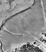
Today there is little left of this faciity except some faintly discernible runways which are only observable from the air. Tumbleweeds and scrub have taken over the rest of the facility with little or no remains. There is a mobile home park on the southeast of the airfield which was built on the end of an old runway.
World War II
World War II, or the Second World War , was a global conflict lasting from 1939 to 1945, involving most of the world's nations—including all of the great powers—eventually forming two opposing military alliances: the Allies and the Axis...
airfield located 2 miles northwest of Leadville, Colorado
Leadville, Colorado
Leadville is a Statutory City that is the county seat of, and the only municipality in, Lake County, Colorado, United States. Situated at an elevation of , Leadville is the highest incorporated city and the second highest incorporated municipality in the United States...
.
History
The airfield was opened as Leadville Municipal Airport sometime prior to World War IIWorld War II
World War II, or the Second World War , was a global conflict lasting from 1939 to 1945, involving most of the world's nations—including all of the great powers—eventually forming two opposing military alliances: the Allies and the Axis...
, and possibly in 1943 it was taken over by the United States Army Air Force Third Air Force
Third Air Force
The Third Air Force is a numbered air force of the United States Air Forces in Europe . It is headquartered at Ramstein Air Base, Germany....
and renamed Leadville Army Airfield.
The airfield was used as an auxiliary field of Peterson Army Air Base
Peterson Air Force Base
Peterson Air Force Base is a base of the United States Air Force located at Colorado Springs in El Paso County, Colorado, United States and it provides runways for the adjacent City of Colorado Springs Municipal Airport under a shared joint civil-military airport arrangement...
in Colorado Springs, Colorado
Colorado Springs, Colorado
Colorado Springs is a Home Rule Municipality that is the county seat and most populous city of El Paso County, Colorado, United States. Colorado Springs is located in South-Central Colorado, in the southern portion of the state. It is situated on Fountain Creek and is located south of the Colorado...
which was a training facility for several photo reconnaissance groups, as well as the 35th Altitude Training Unit.
Later in 1943, Peterson (and Leadville) were transferred to the Second Air Force
Second Air Force
The Second Air Force is a numbered air force of the United States Air Force Air Education and Training Command . It is headquartered at Keesler Air Force Base, Mississippi....
and it possibly became a sub-base for Will Rogers Field
Will Rogers World Airport
Will Rogers World Airport , also known as Will Rogers Airport or simply Will Rogers, is located in southwestern Oklahoma City, Oklahoma 6 miles from downtown and is the principal commercial airport of the Oklahoma City Metropolitan Area...
, Oklahoma
Oklahoma
Oklahoma is a state located in the South Central region of the United States of America. With an estimated 3,751,351 residents as of the 2010 census and a land area of 68,667 square miles , Oklahoma is the 28th most populous and 20th-largest state...
. At the end of the war the airfield was determined to be excess by the military and turned over to the local government for civil use.
At 9,927 ft (3,026 m) above mean sea level the airfield was one of North America's highest. Aircraft performance deteriorates rapidly with altitude, and with a local population of less than 3,000 people there was little or no use for the airfield after the war ended, and it was completely dismantled by 1949.
Today there is little left of this faciity except some faintly discernible runways which are only observable from the air. Tumbleweeds and scrub have taken over the rest of the facility with little or no remains. There is a mobile home park on the southeast of the airfield which was built on the end of an old runway.

