Leagrave
Encyclopedia
For other uses see Leagrave (disambiguation)
Leagrave is a former village and now a suburb of Luton
in Bedfordshire
in the northwest of the town. Connected by train from Leagrave
station into London
and Bedford
by First Capital Connect
. The M1
is close at hand as well as Luton Airport.
which is a Neolithic
D-shaped enclosure in Leagrave Park at the source of the River Lea and is now a protected monument. Waulud's bank consists of a bank and external ditch of around 7 hectares with a turf reveted chalk and gravel bank (built from the excavated ditch material). The ditch itself is about 9 m wide and 2 m deep. Finds at the site have included neolithic Grooved Ware and flint arrow heads. It is a similar site to Durrington Walls
and Marden
and the site was later re-used in the Iron Age
and during the Roman
occupation.
The Icknield Way
, a pre Roman road, passes though Leagrave. Local road names give away its location, 'Roman Road' runs from Oakley Road to Marsh Road. On the other side of Marsh Road as the road enters Limbury
it continues as 'Icknield Road' where there is a gap before the road continues as Icknield Way.
 The River Lea
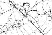
/(Lee) starts in Leagrave before making its way eventually to the Thames, joining in London. The Lee crosses Leagrave Common and receives a tributary called Knapps Brook which joins from culverts under the railway embankment and Toddington Road. Napps Brook is a combination of brooks from East End, Houghton Regis and from the Lewsey
Estate near the old Lewsey Farm. The river once formed one boundary of the Danelaw
. Leagrave Marsh used to be a popular place for the Luton
hatters on their (rare) days off and was, consequently, known as "Blockers' Seaside". The hatmaking industry originally relied on straw plaits, made by farmers' wives, bought and collected by a "plaitman" and brought into the Luton hat factories to be made into straw hat
s. A new artwork has been unveiled in the area, reflecting on this former use of the area.
The manor of Leagrave was held by the Lucy family from 1305 to 1455. The Lucys gave their name to the area of Luton known as Lewsey
.
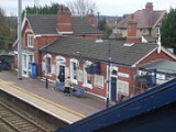
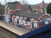
Leagrave station was built by the Midland Railway
company in 1868 on its extension to St Pancras
. The old Midland station buildings still exist, having been carefully restored in the 1980s.
In 1866 the villages of Leagrave and Limbury were formed into the ecclesiastical parish of 'Holy Trinity, (Biscot)'.
Thirty years later, in 1896 Leagrave civil parish
was formed under the provisions of the 'Local Government Act 1894
', in the ecclesiastical parish of Limbury-cum-Biscot.
In 1914 Hewlett & Blondeau Limited
, an aircraft manufacturing business, opened a factory at Leagrave called The Omnia Works. The company was managed by Hilda Hewlett
who lived on site. During the First World War
the factory produced more than 800 aircraft and employed up to 700 people. The business closed in 1920 and in 1926 the factory site was sold to Electrolux
.
The area grew significantly in between the wars and in 1928 the parish was abolished when the boundaries of Luton
were extended to include Leagrave, as well as Limbury and Stopsley
. Further expansion of the area took place during the 1930s; much of the housing stock of the area dates from the 1920s and 1930s. Further large scale construction continued post-war with the construction of the Hockwell Ring
estate and nearby Marsh Farm
. Some of the old farm names live on in the modern road names, Strangers Farm lends its name to the current Strangers Way, Grange Avenue (Grange Road until the 1920s) takes its name from The Grange Farm, and at the edge of Leagrave Marsh was Marsh Farm
, which gives its name to the 1960s estate, Marsh Farm.
Until recently Electrolux was one of the larger employers in the area, however much of the old factory site was sold off over the last ten years or so for re-development into housing. The most recent development on the site was Saxon-Gate. Leagrave is increasingly a commuter area
with many people taking advantage of the train and motorway connections into London and to the North. There have been many smaller developments of former industrial land creating many new apartment blocks and also infil housing.
The current site of the McDonald's
restaurant on Marsh Road was the site of the Three Horseshoes pub, which was demolished in 1994. The roundabout next to McDonalds takes its name from the old pub, and the old pub sign can still be seen in the planting scheme.
Following Leagrave becoming part of Luton in 1928, many local roads were renamed to avoid confusion with existing Luton road names. For example Oak Road became Oakley Road, Cumberland Avenue became Compton Avenue and Salisbury Road became Sarum Road (Sarum being the Roman name for Salisbury).
.
Moorlands School and Nursery was founded in 1891. It was originally located in the town centre before moving to Dunstable Road. In 1958 the school had grown significantly and new premises were needed. The school relocted to Leagrave Hall (built in 1850), a former home of the Filmer family. In September 2011, Moorlands School became a free school
, the first such school in Luton and all of Bedfordshire.
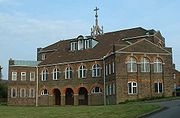 The largest church in the parish is St Lukes on Leagrave High Street. Which was consecrated by the Bishop of Saint Albans in June 1956.
Leagrave Methodist Church
is also on Leagrave High Street. The first Methodist Church in Leagrave opened on the 3 June 1824, and a gallery was added 5 years later in 1829. This Church was rebuilt in 1880.
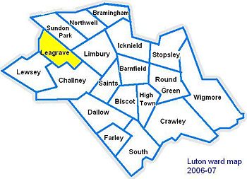
Leagrave ward is represented by Cllr Waheed Akbar(Labour
), Cllr Sheila Roden (Labour) and Cllr Desline Stewart (Labour).
The ward forms part of the parliamentary constituency of Luton North
, and the MP is Kelvin Hopkins
(Labour). Leagrave is within the East of England (European Parliament constituency)
.
Leagrave (disambiguation)
Leagrave is a village in Bedfordshire, England.Leagrave may also refer to:* Leagrave Bench, a style of traditional furniture* Leagrave Railway Station...
Leagrave is a former village and now a suburb of Luton
Luton
Luton is a large town and unitary authority of Bedfordshire, England, 30 miles north of London. Luton and its near neighbours, Dunstable and Houghton Regis, form the Luton/Dunstable Urban Area with a population of about 250,000....
in Bedfordshire
Bedfordshire
Bedfordshire is a ceremonial county of historic origin in England that forms part of the East of England region.It borders Cambridgeshire to the north-east, Northamptonshire to the north, Buckinghamshire to the west and Hertfordshire to the south-east....
in the northwest of the town. Connected by train from Leagrave
Leagrave railway station
Leagrave railway station is located in Leagrave, a suburb in the north of Luton in Bedfordshire, England. Leagrave station is situated on the Midland Main Line 54 km north of London St Pancras International...
station into London
London
London is the capital city of :England and the :United Kingdom, the largest metropolitan area in the United Kingdom, and the largest urban zone in the European Union by most measures. Located on the River Thames, London has been a major settlement for two millennia, its history going back to its...
and Bedford
Bedford
Bedford is the county town of Bedfordshire, in the East of England. It is a large town and the administrative centre for the wider Borough of Bedford. According to the former Bedfordshire County Council's estimates, the town had a population of 79,190 in mid 2005, with 19,720 in the adjacent town...
by First Capital Connect
First Capital Connect
First Capital Connect is a passenger train operating company in England that began operations on the National Rail network on 1 April 2006...
. The M1
M1 motorway
The M1 is a north–south motorway in England primarily connecting London to Leeds, where it joins the A1 near Aberford. While the M1 is considered to be the first inter-urban motorway to be completed in the United Kingdom, the first road to be built to motorway standard in the country was the...
is close at hand as well as Luton Airport.
History
The first settlement in the area was Waulud's BankWaulud's Bank
Waulud's Bank is a possible Neolithic henge in Leagrave, Bedfordshire dating from 3,000BC.The Waulud's Bank earthworks lies on the western edge of the Marsh Farm Estate in Leagrave, Luton. The River Lea forms the western side, its source located within the vicinity of the surrounding marsh...
which is a Neolithic
Neolithic
The Neolithic Age, Era, or Period, or New Stone Age, was a period in the development of human technology, beginning about 9500 BC in some parts of the Middle East, and later in other parts of the world. It is traditionally considered as the last part of the Stone Age...
D-shaped enclosure in Leagrave Park at the source of the River Lea and is now a protected monument. Waulud's bank consists of a bank and external ditch of around 7 hectares with a turf reveted chalk and gravel bank (built from the excavated ditch material). The ditch itself is about 9 m wide and 2 m deep. Finds at the site have included neolithic Grooved Ware and flint arrow heads. It is a similar site to Durrington Walls
Durrington Walls
Durrington Walls is the site of a large Neolithic settlement and later henge enclosure located in the Stonehenge World Heritage Site. It is 2 miles north-east of Stonehenge in the parish of Durrington, just north of Amesbury...
and Marden
Marden, Kent
Marden is a village about 13 km south of Maidstone and civil parish in the Maidstone District of Kent, England. The parish is located on the flood plain of the River Beult near Maidstone. It is on the B2079 road linking the A229 Maidstone with the A21 at Flimwell. It has its own railway...
and the site was later re-used in the Iron Age
Iron Age
The Iron Age is the archaeological period generally occurring after the Bronze Age, marked by the prevalent use of iron. The early period of the age is characterized by the widespread use of iron or steel. The adoption of such material coincided with other changes in society, including differing...
and during the Roman
Ancient Rome
Ancient Rome was a thriving civilization that grew on the Italian Peninsula as early as the 8th century BC. Located along the Mediterranean Sea and centered on the city of Rome, it expanded to one of the largest empires in the ancient world....
occupation.
The Icknield Way
Icknield Way
The Icknield Way is an ancient trackway in southern England. It follows the chalk escarpment that includes the Berkshire Downs and Chiltern Hills.-Background:...
, a pre Roman road, passes though Leagrave. Local road names give away its location, 'Roman Road' runs from Oakley Road to Marsh Road. On the other side of Marsh Road as the road enters Limbury
Limbury
Limbury, or using the full name Limbury-cum-Biscot, was a civil parish in Bedfordshire before becoming part of Luton and has a long history dating back before the Norman conquest of England....
it continues as 'Icknield Road' where there is a gap before the road continues as Icknield Way.


River Lee (England)
The River Lea in England originates in Marsh Farm , Leagrave, Luton in the Chiltern Hills and flows generally southeast, east, and then south to London where it meets the River Thames , the last section being known as Bow Creek.-Etymology:...
/(Lee) starts in Leagrave before making its way eventually to the Thames, joining in London. The Lee crosses Leagrave Common and receives a tributary called Knapps Brook which joins from culverts under the railway embankment and Toddington Road. Napps Brook is a combination of brooks from East End, Houghton Regis and from the Lewsey
Lewsey
Lewsey is a residential area of Luton, near the Luton and Dunstable NHS hospital.Lewsey Takes its name from the former farm on the site of the modern estates, 'Lewsey Farm'...
Estate near the old Lewsey Farm. The river once formed one boundary of the Danelaw
Danelaw
The Danelaw, as recorded in the Anglo-Saxon Chronicle , is a historical name given to the part of England in which the laws of the "Danes" held sway and dominated those of the Anglo-Saxons. It is contrasted with "West Saxon law" and "Mercian law". The term has been extended by modern historians to...
. Leagrave Marsh used to be a popular place for the Luton
Luton
Luton is a large town and unitary authority of Bedfordshire, England, 30 miles north of London. Luton and its near neighbours, Dunstable and Houghton Regis, form the Luton/Dunstable Urban Area with a population of about 250,000....
hatters on their (rare) days off and was, consequently, known as "Blockers' Seaside". The hatmaking industry originally relied on straw plaits, made by farmers' wives, bought and collected by a "plaitman" and brought into the Luton hat factories to be made into straw hat
Straw hat
A straw hat is a brimmed hat that is woven out of straw or reeds. The hat is designed to protect the head from the sun and against heatstroke, but straw hats were also used in fashion and as a decorative element of a uniform.- Manufacture :...
s. A new artwork has been unveiled in the area, reflecting on this former use of the area.
The manor of Leagrave was held by the Lucy family from 1305 to 1455. The Lucys gave their name to the area of Luton known as Lewsey
Lewsey
Lewsey is a residential area of Luton, near the Luton and Dunstable NHS hospital.Lewsey Takes its name from the former farm on the site of the modern estates, 'Lewsey Farm'...
.
Leagrave station was built by the Midland Railway
Midland Railway
The Midland Railway was a railway company in the United Kingdom from 1844 to 1922, when it became part of the London, Midland and Scottish Railway....
company in 1868 on its extension to St Pancras
St Pancras railway station
St Pancras railway station, also known as London St Pancras and since 2007 as St Pancras International, is a central London railway terminus celebrated for its Victorian architecture. The Grade I listed building stands on Euston Road in St Pancras, London Borough of Camden, between the...
. The old Midland station buildings still exist, having been carefully restored in the 1980s.
In 1866 the villages of Leagrave and Limbury were formed into the ecclesiastical parish of 'Holy Trinity, (Biscot)'.
Thirty years later, in 1896 Leagrave civil parish
Civil parish
In England, a civil parish is a territorial designation and, where they are found, the lowest tier of local government below districts and counties...
was formed under the provisions of the 'Local Government Act 1894
Local Government Act 1894
The Local Government Act 1894 was an Act of the Parliament of the United Kingdom that reformed local government in England and Wales outside the County of London. The Act followed the reforms carried out at county level under the Local Government Act 1888...
', in the ecclesiastical parish of Limbury-cum-Biscot.
In 1914 Hewlett & Blondeau Limited
Hewlett & Blondeau
Hewlett & Blondeau was a manufacturer of aeroplanes and other equipment based in Leagrave, Luton, England which produced more than 800 aeroplanes and employed up to 700 people.-History:...
, an aircraft manufacturing business, opened a factory at Leagrave called The Omnia Works. The company was managed by Hilda Hewlett
Hilda Hewlett
Hilda Beatrice Hewlett was the first British aviatrix to earn a pilot's licence. She was also a successful early aviation entrepreneur. She created and ran the first flying school in the United Kingdom. She also created and managed a successful aircraft manufacturing business which produced more...
who lived on site. During the First World War
World War I
World War I , which was predominantly called the World War or the Great War from its occurrence until 1939, and the First World War or World War I thereafter, was a major war centred in Europe that began on 28 July 1914 and lasted until 11 November 1918...
the factory produced more than 800 aircraft and employed up to 700 people. The business closed in 1920 and in 1926 the factory site was sold to Electrolux
Electrolux
The Electrolux Group is a Swedish appliance maker.As of 2010 the 2nd largest home appliance manufacturer in the world after Whirlpool, its products sell under a variety of brand names including its own and are primarily major appliances and vacuum cleaners...
.
The area grew significantly in between the wars and in 1928 the parish was abolished when the boundaries of Luton
Luton
Luton is a large town and unitary authority of Bedfordshire, England, 30 miles north of London. Luton and its near neighbours, Dunstable and Houghton Regis, form the Luton/Dunstable Urban Area with a population of about 250,000....
were extended to include Leagrave, as well as Limbury and Stopsley
Stopsley
Stopsley is a ward in the north-east of Luton. Originally a hill-top village settlement, most of the urbanised part of the civil parish of Stopsley became part of Luton when the boundaries were extended in 1933, with the rural areas going to Hyde and Streatley.After the Second World War, there was...
. Further expansion of the area took place during the 1930s; much of the housing stock of the area dates from the 1920s and 1930s. Further large scale construction continued post-war with the construction of the Hockwell Ring
Hockwell Ring
Hockwell Ring is a 1950s and 1960s built council estate in the Leagrave area of Luton, Bedfordshire. The estate was built as part of the post-war expansion of Luton, at a similar time to Marsh Farm. Hockwell Ring is not a particularly large estate...
estate and nearby Marsh Farm
Marsh farm
Marsh Farm is a large housing estate in Luton, Bedfordshire near to Leagrave and Limbury, mainly of council and social housing.The estate was built in the late 1960s, with a mixture of flats and houses as part of the post-war expansion of Luton. The estates at Farley Hill, Hockwell Ring and...
. Some of the old farm names live on in the modern road names, Strangers Farm lends its name to the current Strangers Way, Grange Avenue (Grange Road until the 1920s) takes its name from The Grange Farm, and at the edge of Leagrave Marsh was Marsh Farm
Marsh farm
Marsh Farm is a large housing estate in Luton, Bedfordshire near to Leagrave and Limbury, mainly of council and social housing.The estate was built in the late 1960s, with a mixture of flats and houses as part of the post-war expansion of Luton. The estates at Farley Hill, Hockwell Ring and...
, which gives its name to the 1960s estate, Marsh Farm.
Until recently Electrolux was one of the larger employers in the area, however much of the old factory site was sold off over the last ten years or so for re-development into housing. The most recent development on the site was Saxon-Gate. Leagrave is increasingly a commuter area
Metropolitan area
The term metropolitan area refers to a region consisting of a densely populated urban core and its less-populated surrounding territories, sharing industry, infrastructure, and housing. A metropolitan area usually encompasses multiple jurisdictions and municipalities: neighborhoods, townships,...
with many people taking advantage of the train and motorway connections into London and to the North. There have been many smaller developments of former industrial land creating many new apartment blocks and also infil housing.
The current site of the McDonald's
McDonald's
McDonald's Corporation is the world's largest chain of hamburger fast food restaurants, serving around 64 million customers daily in 119 countries. Headquartered in the United States, the company began in 1940 as a barbecue restaurant operated by the eponymous Richard and Maurice McDonald; in 1948...
restaurant on Marsh Road was the site of the Three Horseshoes pub, which was demolished in 1994. The roundabout next to McDonalds takes its name from the old pub, and the old pub sign can still be seen in the planting scheme.
Following Leagrave becoming part of Luton in 1928, many local roads were renamed to avoid confusion with existing Luton road names. For example Oak Road became Oakley Road, Cumberland Avenue became Compton Avenue and Salisbury Road became Sarum Road (Sarum being the Roman name for Salisbury).
Etymology
The village was recorded in 1224 as Littegraue, intimating that its name means 'Light-coloured, or lightly wooded, grove'. However, another source suggests its name originates from Lygegrove: "Lyge" being an old name for the River LeaRiver Lee (England)
The River Lea in England originates in Marsh Farm , Leagrave, Luton in the Chiltern Hills and flows generally southeast, east, and then south to London where it meets the River Thames , the last section being known as Bow Creek.-Etymology:...
.
New Bridge Under the Mainline Railway
The Bedford to London railway line cuts a portion of Luton off from the rest of it, this scheme will add a new crossing under the track near Leagrave park. This scheme is a reserve scheme and as such may only be developed should one of the 79 chosen schemes not be able to be completed.Local Schools and Education
- Leagrave Primary School, Strangers Way
- Beechwood Primary School, Linden Road
- Moorlands Free School, Leagrave Hall
- Lealands High School, Sundon Park Road
- Leagrave Library, Marsh Road
Moorlands School and Nursery was founded in 1891. It was originally located in the town centre before moving to Dunstable Road. In 1958 the school had grown significantly and new premises were needed. The school relocted to Leagrave Hall (built in 1850), a former home of the Filmer family. In September 2011, Moorlands School became a free school
Free school (England)
A Free school is a school in England funded by the taxpayer, non-selective and free to attend but not controlled by local authorities. The concept of free schools is based upon a similar model found in Sweden as well as US charter schools....
, the first such school in Luton and all of Bedfordshire.
Churches

Leagrave Methodist Church
Methodism
Methodism is a movement of Protestant Christianity represented by a number of denominations and organizations, claiming a total of approximately seventy million adherents worldwide. The movement traces its roots to John Wesley's evangelistic revival movement within Anglicanism. His younger brother...
is also on Leagrave High Street. The first Methodist Church in Leagrave opened on the 3 June 1824, and a gallery was added 5 years later in 1829. This Church was rebuilt in 1880.
Politics
See also Politics in LutonPolitics in Luton
Luton, England, is a unitary authority, and remains part of the ceremonial county of Bedfordshire. Luton is currently represented on three different tiers of Government.*Luton Borough Council *East of England Regional Assembly...
Leagrave ward is represented by Cllr Waheed Akbar(Labour
Labour Party (UK)
The Labour Party is a centre-left democratic socialist party in the United Kingdom. It surpassed the Liberal Party in general elections during the early 1920s, forming minority governments under Ramsay MacDonald in 1924 and 1929-1931. The party was in a wartime coalition from 1940 to 1945, after...
), Cllr Sheila Roden (Labour) and Cllr Desline Stewart (Labour).
The ward forms part of the parliamentary constituency of Luton North
Luton North (UK Parliament constituency)
Luton North is a borough constituency represented in the House of Commons of the Parliament of the United Kingdom. It elects one Member of Parliament by the first past the post system of election.-Boundaries:...
, and the MP is Kelvin Hopkins
Kelvin Hopkins
Kelvin Peter Hopkins is a British Labour Party politician, who has been the Member of Parliament for Luton North since 1997.-Background:...
(Labour). Leagrave is within the East of England (European Parliament constituency)
East of England (European Parliament constituency)
East of England is a constituency of the European Parliament. It currently elects 7 MEPs using the d'Hondt method of party-list proportional representation.- Boundaries :...
.

Local Attractions
|
Local Newspapers
Two weekly newspapers are delivered free to all houses in Leagrave, with news about Leagrave and the surrounding area.- Herald and Post (Luton based) – Delivered every Thursday
- Luton on Sunday – Delivered every Sunday

