
Lecanvey
Encyclopedia
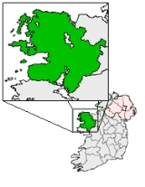
Lecanvey or Leckanvy is a seaside village in County Mayo
, Ireland
, between Westport
and Louisburgh, about 2 km west of Murrisk
. It has a small beach with Lecanvey Pier. To the south is Croagh Patrick
. To the west is Clare Island
.
The Lecanvey Community Alliance was constituted in 2006 to improve the environment of the parts of the area which do not fall into the catchment area of Murrisk or of Louisburgh. Local concerns include improvement of roads and pavements, speed limits, litter control, hedging and mowing, and place-names and area signage.
County Mayo
County Mayo is a county in Ireland. It is located in the West Region and is also part of the province of Connacht. It is named after the village of Mayo, which is now generally known as Mayo Abbey. Mayo County Council is the local authority for the county. The population of the county is 130,552...
, Ireland
Republic of Ireland
Ireland , described as the Republic of Ireland , is a sovereign state in Europe occupying approximately five-sixths of the island of the same name. Its capital is Dublin. Ireland, which had a population of 4.58 million in 2011, is a constitutional republic governed as a parliamentary democracy,...
, between Westport
Westport, County Mayo
Westport is a town in County Mayo, Ireland. It is situated on the west coast at the south-east corner of Clew Bay, an inlet of the Atlantic Ocean....
and Louisburgh, about 2 km west of Murrisk
Murrisk
Murrisk is one of the Baronial divisions of County Mayo and also a village in County Mayo, Ireland, on the south side of Clew Bay, about 8 km west of Westport and 4 km east of Lecanvey....
. It has a small beach with Lecanvey Pier. To the south is Croagh Patrick
Croagh Patrick
Croagh Patrick , nicknamed the Reek, is a tall mountain and an important site of pilgrimage in County Mayo, Republic of Ireland. It is from Westport, above the villages of Murrisk and Lecanvey. It is the third highest mountain in County Mayo after Mweelrea and Nephin. On "Reek Sunday", the last...
. To the west is Clare Island
Clare Island
Clare Island is a mountainous island guarding the entrance to Clew Bay in County Mayo, Ireland. It is famous as the home of the pirate queen, Gráinne O'Malley...
.
The Lecanvey Community Alliance was constituted in 2006 to improve the environment of the parts of the area which do not fall into the catchment area of Murrisk or of Louisburgh. Local concerns include improvement of roads and pavements, speed limits, litter control, hedging and mowing, and place-names and area signage.
Townlands served by the Lecanvey Community Alliance
| Name | Ainm | Meaning | Area |
|---|---|---|---|
| Bouris (OS maps: Boheh) | An Bhuiríos (or Both Theith) | 'the fortified settlement' or 'the warm hut' | 360 acres (1.5 km²) |
| Carrowmacloughlin | Ceathrú Mhic Lochlainn | 'MacLoughlin's quarter' | 600 acres (2.4 km²) |
| Cartoor | Cartúr | 'a parcel of land 64 acres (258,999 m²)' | 132 acre (0.53418552 km²) |
| Durless | Dúir Lios | 'strong fort' | 1092 acres (4.4 km²) |
| Furrigal (OS maps: Furgill) | Fóirghiall | 'pledge for protection, hostage for safety' | 439 acres (1.8 km²) |
| Glenbaun | An Gleann Bán | 'the white valley' | 338 acres (1.4 km²) |
| Glencally | Gleann an Calaidh | 'glen of the marshy meadow' | 511 acres (2.1 km²) |
| Gloshpatrick (OS maps: Glaspatrick) | Glais Phádraig | 'Patrick's streambed' | 823 acres (3.3 km²) |
| Gorteendarragh | Goirtín Darach | 'little oak field' | 12 acres (48,562.3 m²) |
| Kilsallagh Lower | Coill Saileach Íochtair | 'lower wood of willows' | 702 acres (2.8 km²) |
| Kilsallagh Upper | Coill Saileach Uachtair | 'upper wood of willows' | 347 acres (1.4 km²) |
| Kinnock (OS maps: Kinknock) | Ceann Cnoic | 'head of the rock' | 279 acres (1.1 km²) |
| Lecanvey (OS maps: Leckanvy) | Leac an Anfa | 'flagstone of the storm' | 786 acres (3.2 km²) |
| Lecanvey Pier | Cé Leac an Anfa | not a proper townland | |
| Mullagh | Mullach | 'summit' | 339 acres (1.4 km²) |
| Tangincartoor | Teanga an Chartúir | 'Cartoor's tongue' | 234 acre (0.94696524 km²) |
| Thornhill | Cnoc na Sceiche | 'hill of the hawthorn' | 307 acres (1.2 km²) |
See also
- List of towns and villages in Ireland