

List of Pennsylvania state historical markers in Berks County
Encyclopedia

This is intended to be a complete list of the official state historical markers placed in Berks County, Pennsylvania
Berks County, Pennsylvania
-Demographics:As of the census of 2000, there were 373,638 people, 141,570 households, and 98,532 families residing in the county. The population density was 435 people per square mile . There were 150,222 housing units at an average density of 175 per square mile...
by the Pennsylvania Historical and Museum Commission
Pennsylvania Historical and Museum Commission
The Pennsylvania Historical and Museum Commission is the governmental agency of the Commonwealth of Pennsylvania responsible for the collection, conservation and interpretation of Pennsylvania's historic heritage...
(PHMC). The locations of the historical markers, as well as the latitude and longitude coordinates as provided by the PHMC's database, are included below when available. There are 68 historical markers located in Berks County.
Historical markers
| Marker title | Image | Date dedicated | Location | Marker type | Topics |
|---|---|---|---|---|---|
| Anthony Sadowski Anthony Sadowski Anthony Sadowski was a Polish-born Indian trader and interpreter employed by the provincial governor of Pennsylvania as an Indian agent in the western country.-Early life:Anthony Sadowski was born in about 1669 in Poland... |
U.S. 422 eastbound near graveyard, Douglassville 40.25775°N 75.72897°W |
Roadside | Early Settlement, Ethnic & Immigration, Government & Politics, Government & Politics 18th Century, Native American | ||
| Baird House | 5th & Washington Sts., SW corner, Reading (Missing) °N °W |
City | Environment, Professions & Vocations | ||
| Ben Austrian | New Bethel Union Church Cemetery, RD 2, Kempton 40.63282°N 75.89217°W |
Roadside | Artists | ||
| Berks County | Courthouse, N. 6th & Court Sts., Reading 40.33648°N 75.92587°W |
City | Government & Politics, Government & Politics 18th Century, Iron | ||
| Bethel A.M.E. Church Bethel A.M.E. Church (Reading, Pennsylvania) Bethel A.M.E. Church is a historic church at 119 North 10th Street in Reading, Pennsylvania.It was built in 1837 and added to the National Register of Historic Places in 1979.... |
119 N. 10th St., Reading 40.34255°N 75.9256°W |
City | African American, Buildings, Religion, Underground Railroad | ||
| Carl A. Spaatz | 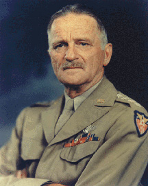 |
Pa. 562 (S. Reading Ave.) at W. 2nd St., Boyertown 40.33177°N 75.64163°W |
Roadside | Military, Military Post-Civil War | |
| Charming Forge | U.S. 422, Womelsdorf 40.36577°N 76.17993°W |
Roadside | American Revolution, Buildings, Business & Industry, Iron, Professions & Vocations | ||
| Christ Little Tulpehocken Church | SR 4010 W of Bernville 40.42213°N 76.13218°W |
Roadside | Buildings, Religion | ||
| Colebrookdale Furnace | n/a | Pa. 562 near SR 2040 SW of Boyertown 40.32323°N 75.65392°W |
Roadside | Business & Industry, Furnaces, Iron | |
| Conrad Weiser Conrad Weiser Weiser's colonial service began in 1731. The Iroquois sent Shikellamy, an Oneida chief, as an emissary to other tribes and the British. Shikellamy lived on the Susquehanna River at Shamokin village, near present-day Sunbury, Pennsylvania. An oral tradition holds that Weiser met Shikellamy while... |
 |
U.S. 422, Weiser Homestead, E of Womelsdorf 40.36013°N 76.17213°W |
Roadside | Early Settlement, Government & Politics, Native American | |
| Conrad Weiser Trading Post | 505 Penn St., Penn Sq., Reading 40.33555°N 75.92775°W |
City | Buildings, Early Settlement, Government & Politics, Native American, Professions & Vocations | ||
| Daniel Boone Daniel Boone Daniel Boone was an American pioneer, explorer, and frontiersman whose frontier exploits mad']'e him one of the first folk heroes of the United States. Boone is most famous for his exploration and settlement of what is now the Commonwealth of Kentucky, which was then beyond the western borders of... |
n/a | U.S. 422, 2 miles SE of Baumstown 40.26767°N 75.76107°W |
Roadside | Education, Houses & Homesteads, Professions & Vocations | |
| Daniel Boone Daniel Boone Daniel Boone was an American pioneer, explorer, and frontiersman whose frontier exploits mad']'e him one of the first folk heroes of the United States. Boone is most famous for his exploration and settlement of what is now the Commonwealth of Kentucky, which was then beyond the western borders of... |
U.S. 422 westbound at SR 2041 just E of Baumstown; U.S. 422 eastbound at Baumstown Union Sunday School 40.27938°N 75.80183°W |
Roadside | Education, Houses & Homesteads, Professions & Vocations | ||
| Daniel Boone (1734-1820) - PLAQUE Daniel Boone Daniel Boone was an American pioneer, explorer, and frontiersman whose frontier exploits mad']'e him one of the first folk heroes of the United States. Boone is most famous for his exploration and settlement of what is now the Commonwealth of Kentucky, which was then beyond the western borders of... |
n/a | US 422 between Baumstown and Douglassville 40.26756°N 75.76106°W |
Plaque | Exploration | |
| Daniel Boone Homestead Daniel Boone Homestead The Daniel Boone Homestead, the birthplace of American frontiersman Daniel Boone, is a museum that is administered by the Pennsylvania Historical and Museum Commission near Birdsboro, Berks County, Pennsylvania in the United States. It is located on nearly and is the largest site administered by... |
n/a | SR 2041 N of Baumstown 40.29073°N 75.79435°W |
Roadside | Buildings, Early Settlement, Houses & Homesteads | |
| De Benneville House | Pa. 622, 1.5 miles N of Yellow House 40.34335°N 75.7618°W |
Roadside | Houses & Homesteads, Religion | ||
| De Turk House | Junction PA 73 & Memorial Hwy. (PA 662), near DeTurk Rd., just S of Oley 40.38373°N 75.78669°W |
Roadside | Early Settlement, Ethnic & Immigration, Religion | ||
| Doctor Jonathan Potts | 545 Penn St., Penn Sq., Reading 40.33543°N 75.92632°W |
City | American Revolution, Military | ||
| Dr. Bodo Otto |  |
525 Penn St., Penn Sq., Reading 40.33555°N 75.92775°W |
City | American Revolution, Medicine & Science, Military, Professions & Vocations | |
| Duryea Drive | Intersection of Clymer & 13th Sts. at Park Dr., Reading 40.33473°N 75.91112°W |
Roadside | Business & Industry, Invention, Oil & Gas, Professions & Vocations, Transportation | ||
| Duryea Drive | In Reading at 1st curve on road to Pagoda, about 65' from curve °N °W |
Roadside | Business & Industry, Invention, Oil & Gas, Professions & Vocations, Transportation | ||
| Duryea Drive | In Reading, on Mount Penn at Pagoda 40.33607°N 75.90565°W |
Roadside | Business & Industry, Invention, Oil & Gas, Professions & Vocations, Transportation | ||
| Eight-Cornered School | U.S. 422 in Sinking Spring (Missing) °N °W |
City | Education, Religion | ||
| Exeter Friends Meeting | Meetinghouse Road, .5 mile S of Pa. 562 & 2 mile W of Yellow House 40.3129°N 75.78443°W |
Roadside | Abraham Lincoln, Buildings, Religion | ||
| Federal Inn | 445 Penn St., Penn Sq., Reading 40.33543°N 75.92822°W |
City | Buildings, Business & Industry, George Washington, Military, Inns & Taverns, Whiskey Rebellion | ||
| Fisher House | Pa. 622, 1.4 miles N of Yellow House 40.34113°N 75.76095°W |
Roadside | Buildings, Houses & Homesteads | ||
| Fort Henry | Pa. 501, 2 miles N of Bethel 40.49178°N 76.31645°W |
Roadside | Forts, French & Indian War, Military | ||
| Goshenhoppen | Pa. 100 (7th & Main Sts.), Bally 40.40268°N 75.58588°W |
Roadside | Early Settlement, Education, Religion | ||
| Henry A. Muhlenberg | 400 Penn St., Reading 40.33523°N 75.9297°W |
City | Government & Politics, Religion | ||
| Hereford Furnace | Pa. 29 & 100 at junction SR 1010, Hereford 40.4497°N 75.55232°W |
Roadside | Business & Industry, Furnaces, Iron | ||
| Hessian Camp | Mineral Spring Rd. (Business U.S. 422 westbound) at 18th St., Reading 40.33168°N 75.90163°W |
Roadside | American Revolution, Ethnic & Immigration | ||
| Hessian Camp | Pa. 73 & U.S. 422, Mineral Spring Park (Missing) °N °W |
Roadside | Ethnic & Immigration | ||
| Hiester Home | 439 Penn St., Penn Sq., Reading 40.33542°N 75.92862°W |
City | American Revolution, Government & Politics, Governors, Houses & Homesteads, Military | ||
| Hopewell Village | Pa. 10, S of Plowville °N °W |
Roadside | Business & Industry, Furnaces, Iron | ||
| Hopewell Village | U.S. 422 east & westbound at Pa. 82, Baumstown 40.28077°N 75.8057°W |
Roadside | Business & Industry, Furnaces, Iron | ||
| Hunter Liggett Hunter Liggett Hunter Liggett was a lieutenant general of the United States Army. His forty-two years of service spanned the period from the Indian campaigns to trench warfare.-Biography:... |
145 S. 6th St. at Chestnut, Reading 40.33232°N 75.92593°W |
City | Military, Military Post-Civil War | ||
| James Maurer (1864-1944) |  |
Heritage Park near Workers' Memorial, 8th & Canal Sts., Reading 40.32493°N 75.92622°W |
Roadside | Government & Politics 20th Century, Labor | |
| Jeremiah Sweinhart and Successors | 3rd. & Walnut Sts., Boyertown 40.33315°N 75.64012°W |
Roadside | Agriculture, Business & Industry, Entrepreneurs, Military, Transportation | ||
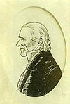
| John A. Shulze |  |
Conrad Weiser Pkwy. (US 422) at Main St. & Longs Church Ln., outside Stouchsburg 40.38383°N 76.24686°W |
Roadside | Government & Politics, Government & Politics 19th Century, Governors | |
| Joseph Hiester Joseph Hiester Joseph Hiester was the fifth Governor of Pennsylvania from 1820 to 1823. He was a member of the Hiester family political dynasty.-Biography:... |
 |
Pa. 183 at SR 3051 & 3053 near Leinbachs 40.38827°N 75.99267°W |
Roadside | American Revolution, Government & Politics, Governors, Mansions & Manors, Military | |
| Lincoln Homestead Mordecai Lincoln House (Lorane, Pennsylvania) The Mordecai Lincoln House is a historic house in Exeter Township, Berks County, Pennsylvania built c. 1733 by Mordecai Lincoln, the great-great-grandfather of President Abraham Lincoln... |
5700 Perkiomen Ave. (US 422), near Lincoln Rd., Reading / Exeter Twp. °N °W |
Roadside | Abraham Lincoln, Early Settlement, Government & Politics 18th Century, Houses & Homesteads | ||
| Northkill Amish | Old U.S. 22, 1 mile W of Shartlesville 40.51207°N 76.11982°W |
Roadside | Early Settlement, Native American, Religion | ||
| Oley Moravians | Memorial Hwy. (PA 622), near Mine Ln., 1 mile S of Oley 40.37348°N 75.77713°W |
Roadside | Early Settlement, Education, Religion | ||
| Penn's Common | Perkiomen Ave. (Business U.S. 422 westbound) at 11th & Penn Sts., Reading 40.33505°N 75.91585°W |
City | Government & Politics, Government & Politics 18th Century, William Penn | ||
| Pilger Ruh | Bethel Rd. (PA 501) at Pilger Ruh Rd., N of Bethel near Schuylkill Co. line 40.51327°N 76.33735°W |
Roadside | Environment, Native American, Paths & Trails, Religion | ||
| Reading Reading, Pennsylvania Reading is a city in southeastern Pennsylvania, USA, and seat of Berks County. Reading is the principal city of the Greater Reading Area and had a population of 88,082 as of the 2010 census, making it the fifth most populated city in the state after Philadelphia, Pittsburgh, Allentown and Erie,... |
 |
n/a | Lancaster Ave. (Bus. 222) at Summit Ave., S end of city 40.36895°N 75.92688°W |
Roadside | Business & Industry, Cities & Towns, Early Settlement, Ethnic & Immigration, Government & Politics |
| Reading Reading, Pennsylvania Reading is a city in southeastern Pennsylvania, USA, and seat of Berks County. Reading is the principal city of the Greater Reading Area and had a population of 88,082 as of the 2010 census, making it the fifth most populated city in the state after Philadelphia, Pittsburgh, Allentown and Erie,... |
|
U.S. 122 S °N °W |
Roadside | Business & Industry, Cities & Towns, Early Settlement, Ethnic & Immigration, Government & Politics | |
| Reading Reading, Pennsylvania Reading is a city in southeastern Pennsylvania, USA, and seat of Berks County. Reading is the principal city of the Greater Reading Area and had a population of 88,082 as of the 2010 census, making it the fifth most populated city in the state after Philadelphia, Pittsburgh, Allentown and Erie,... |
|
U.S. 122 N °N °W |
Roadside | Business & Industry, Cities & Towns, Early Settlement, Ethnic & Immigration, Government & Politics | |
| Reading Reading, Pennsylvania Reading is a city in southeastern Pennsylvania, USA, and seat of Berks County. Reading is the principal city of the Greater Reading Area and had a population of 88,082 as of the 2010 census, making it the fifth most populated city in the state after Philadelphia, Pittsburgh, Allentown and Erie,... |
|
n/a | N 5th St. Hwy. / Allentown Pike (US 222) at N city line, just S of Warren St. Bypass (PA 12) °N °W |
Roadside | Business & Industry, Cities & Towns, Early Settlement, Ethnic & Immigration, Government & Politics |
| Reading Reading, Pennsylvania Reading is a city in southeastern Pennsylvania, USA, and seat of Berks County. Reading is the principal city of the Greater Reading Area and had a population of 88,082 as of the 2010 census, making it the fifth most populated city in the state after Philadelphia, Pittsburgh, Allentown and Erie,... |
|
n/a | Penn Ave. (Bus. Rt. 422) just W of Ben Franklin Hwy. / Conrad Weiser Pkwy. cloverleaf 40.33472°N 75.94073°W |
Roadside | Business & Industry, Cities & Towns, Ethnic & Immigration |
| Reading Railroad Massacre Reading Railroad Massacre The Reading Railroad Massacre, in which ten people lost their lives, was the tragic climax of local events in Reading, Pennsylvania during the Great Railroad Strike of 1877.... |
 |
7th & Penn Sts., Reading 40.33522°N 75.9242°W |
City | Labor, Railroads, Transportation | |
| Rhoads Opera House Fire | Fairview Cemetery, north side of W Philadelphia Ave., Boyertown °N °W |
Roadside | Buildings, Government & Politics 20th Century | ||
| Robesonia Furnace | n/a | U.S. 422 (Penn Ave.) at Freeman St., Robesonia 40.34977°N 76.1289°W |
Roadside | Buildings, Business & Industry, Furnaces, Iron, Professions & Vocations | |
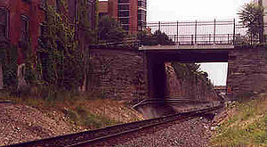
| Skew Bridge Skew Bridge The Skew Bridge, also known as the Askew Bridge and nicknamed the Soap and Whiskey Bridge, is a historical skew arch bridge completed in 1857 carrying two tracks of the Reading Railroad at an angle over Sixth Street in Reading, Berks County, Pennsylvania.The bridge was designed by Richard Osborne... |
N. 6th St. at railroad bridge, near Woodward St., Reading 40.34265°N 75.92572°W |
City | Bridges, Railroads, Transportation | ||
| Solomon Boscov | 1400 Block N. 9th St., Reading 40.35635°N 75.91933°W |
City | Business & Industry, Ethnic & Immigration | ||
| Swedish Pioneers | E Main St. / W Schuylkill Rd. (PA 724) just NW of River Bridge Rd., 5 miles SE of Birdsboro 40.25273°N 75.72957°W |
Roadside | Early Settlement, Ethnic & Immigration, Houses & Homesteads, William Penn | ||
| Thomas Mifflin Thomas Mifflin Thomas Mifflin was an American merchant and politician from Philadelphia, Pennsylvania. He was a major general in the Continental Army during the American Revolution, a member of the Pennsylvania Provincial Assembly, a Continental Congressman from Pennsylvania, President of the Continental... |
U.S. 222 (E. Lancaster Ave.) at Mifflin Blvd., Shillington 40.307°N 75.95936°W |
Roadside | American Revolution, Government & Politics, Government & Politics 18th Century, Governors, Military | ||
| Thomas Rutter | Pine Forge Academy off Pine Forge Rd. (SR 2063), Pine Forge 40.281°N 75.70375°W |
City | African American, Business & Industry, Education, Iron, Mansions & Manors, Professions & Vocations, Underground Railroad | ||
| Thompson's Rifle Battalion: Capt. George Nagel's Company | 940 Centre Ave. (Pa. 61), Greenfield Manor section of Reading °N °W |
Roadside | American Revolution, Military | ||
| Tulpehocken Path | Lancaster Ave. (PA 501) at Schubert Rd., just N of I-78/US22), 1 mile N of Bethel 40.47822°N 76.2955°W |
Roadside | Forts, French & Indian War, Military, Native American, Paths & Trails | ||
| Tulpehocken Path | Conrad Weiser Pkwy. / W Penn Ave. (US 422), at Conrad Weiser Homestead E of Womelsdorf 40.36013°N 76.17213°W |
Roadside | Government & Politics, Native American, Paths & Trails, Transportation, William Penn | ||
| Tulpehocken Path | PA 419 N of Host (Missing) °N °W |
Roadside | Government & Politics, Native American, Paths & Trails, Transportation, William Penn | ||
| Union Canal Union Canal (Pennsylvania) The Union Canal was a towpath canal that existed in southeastern Pennsylvania in the United States during the 19th century. First proposed in 1690 to connect Philadelphia with the Susquehanna River, it ran approximately 75 mi from Middletown on the Susquehanna below Harrisburg to Reading on... |
Morgantown Rd. (PA 10) & Philadelphia Ave. (PA 724), 2 miles S of Reading 40.29778°N 75.92598°W |
Roadside | Business & Industry, Canals, Mills, Navigation, Transportation | ||
| Union Canal Union Canal (Pennsylvania) The Union Canal was a towpath canal that existed in southeastern Pennsylvania in the United States during the 19th century. First proposed in 1690 to connect Philadelphia with the Susquehanna River, it ran approximately 75 mi from Middletown on the Susquehanna below Harrisburg to Reading on... |
Pa. 183, .9 mile SE of Bernville °N °W |
Roadside | Business & Industry, Canals, Mills, Navigation, Transportation | ||
| Union Canal Union Canal (Pennsylvania) The Union Canal was a towpath canal that existed in southeastern Pennsylvania in the United States during the 19th century. First proposed in 1690 to connect Philadelphia with the Susquehanna River, it ran approximately 75 mi from Middletown on the Susquehanna below Harrisburg to Reading on... |
Upper Van Reed Rd. near Tulpehocken Creek, .1 mile S of Leinbachs, Bernville °N °W |
Roadside | Business & Industry, Canals, Mills, Navigation, Transportation | ||
| Wallace Stevens (1879-1955) Wallace Stevens Wallace Stevens was an American Modernist poet. He was born in Reading, Pennsylvania, educated at Harvard and then New York Law School, and spent most of his life working as a lawyer for the Hartford insurance company in Connecticut.His best-known poems include "Anecdote of the Jar",... |
323 N 5th St., Reading 40.3407°N 75.9277°W |
City | Writers | ||
| William Penn - First Visit to America - PLAQUE William Penn William Penn was an English real estate entrepreneur, philosopher, and founder of the Province of Pennsylvania, the English North American colony and the future Commonwealth of Pennsylvania. He was an early champion of democracy and religious freedom, notable for his good relations and successful... |
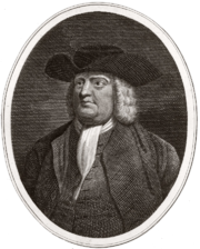 |
US 422, .8 mile SE of Baumstown (264 E Ben Franklin Hwy., Birdsboro) 40.27375°N 75.78053°W |
Plaque | Exploration, William Penn | |
| William Strong William Strong (judge) William Strong was an American jurist and politician. He was a justice on the Supreme Court of Pennsylvania and an Associate Justice on the Supreme Court of the United States.-Early life:... |
NW corner, 5th & Court Sts., Reading 40.33622°N 75.92788°W |
City | Government & Politics, Government & Politics 19th Century, Professions & Vocations |
See also
- List of Pennsylvania state historical markers
- National Register of Historic Places listings in Berks County, Pennsylvania