

List of Pennsylvania state historical markers in Cameron County
Encyclopedia

This is intended to be a complete list of the official state historical markers placed in Cameron County, Pennsylvania
Cameron County, Pennsylvania
As of the census of 2000, there were 5,974 people, 2,465 households, and 1,624 families residing in the county. The population density was 15 people per square mile . There were 4,592 housing units at an average density of 12 per square mile...
by the Pennsylvania Historical and Museum Commission
Pennsylvania Historical and Museum Commission
The Pennsylvania Historical and Museum Commission is the governmental agency of the Commonwealth of Pennsylvania responsible for the collection, conservation and interpretation of Pennsylvania's historic heritage...
(PHMC). The locations of the historical markers, as well as the latitude and longitude coordinates as provided by the PHMC's database, are included below when available. There are seven historical markers located in Cameron County.
Historical markers
| Marker title | Image | Date dedicated | Location | Marker type | Topics |
|---|---|---|---|---|---|
| Allegheny Portage | Junction Pa. 120 & 155 E of Emporium 41.50802°N 78.22032°W |
Roadside | Native American, Transportation | ||
| Bucktails, The Bucktails The Bucktails may refer to one of two organizations that were particularly characterized and identified by the wearing of a bucktail in their headgear.... |
Junction 3rd St. / Bucktail Trail Hwy. (PA 120) & Bridge St. (PA 555), Driftwood °N °W |
Roadside | Civil War, Military | ||
| Cameron County Cameron County, Pennsylvania As of the census of 2000, there were 5,974 people, 2,465 households, and 1,624 families residing in the county. The population density was 15 people per square mile . There were 4,592 housing units at an average density of 12 per square mile... |
County Courthouse, Pa. 120, Emporium 41.5128°N 78.23642°W |
City | Government & Politics, Government & Politics 19th Century | ||
| Portage Path | Pa. 155, 5.5 miles N of Emporium (Missing) °N °W |
Roadside | Native American, Navigation, Paths & Trails, Transportation | ||
| Sinnemahoning Path Sinnemahoning Path The Sinnemahoning Path is an ancient trail which passes through what will be called Keating on its way to the upper Alleghenies. The Sinnemahoning Path followed the West Branch of the Susquehanna from “the Great Island” at Lock Haven to the Sinnemahoning Creek at Keating, to Portage Creek, then to... |
CCC Memorial Hwy. (PA 120), 3.8 miles S of Emporium and NW of Cameron 41.46368°N 78.19812°W |
Roadside | Native American, Paths & Trails, Transportation | ||
| Sinnemahoning Path Sinnemahoning Path The Sinnemahoning Path is an ancient trail which passes through what will be called Keating on its way to the upper Alleghenies. The Sinnemahoning Path followed the West Branch of the Susquehanna from “the Great Island” at Lock Haven to the Sinnemahoning Creek at Keating, to Portage Creek, then to... |
Pa. 120, 1.5 miles N of Driftwood °N °W |
Roadside | Native American, Paths & Trails, Transportation | ||
| Tom Mix Tom Mix Thomas Edwin "Tom" Mix was an American film actor and the star of many early Western movies. He made a reported 336 films between 1910 and 1935, all but nine of which were silent features... |
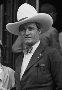 |
At birthplace, Mix Run Rd. across creek from PA 555, W of Driftwood 41.33658°N 78.18815°W |
Roadside | Motion Pictures & Television |