

List of Pennsylvania state historical markers in Delaware County
Encyclopedia
This is intended to be a complete list of the official state historical markers placed in Delaware County, Pennsylvania
Delaware County, Pennsylvania
Delaware County is a county located in the U.S. state of Pennsylvania. As of 2010, the population was 558,979, making it Pennsylvania's fifth most populous county, behind Philadelphia, Allegheny, Montgomery, and Bucks counties....
by the Pennsylvania Historical and Museum Commission
Pennsylvania Historical and Museum Commission
The Pennsylvania Historical and Museum Commission is the governmental agency of the Commonwealth of Pennsylvania responsible for the collection, conservation and interpretation of Pennsylvania's historic heritage...
(PHMC). The locations of the historical markers, as well as the latitude and longitude coordinates as provided by the PHMC's database, are included below when available. There are 56 historical markers located in Delaware County.
Historical markers
| Marker title | Image | Date dedicated | Location | Marker type | Topics |
|---|---|---|---|---|---|
| Abraham L. Pennock | At library on Maple Avenue between Wayne and Hazel, off S. State Rd. (SR 2026), Upper Darby 39.9623°N 75.2736°W |
Roadside | African American, Government & Politics, Government & Politics 19th Century, Underground Railroad, Women | ||
| American Viscose Co. | Viscose Village Plaza, Marcus Hook 39.8217°N 75.4122°W |
Roadside | Buildings, Business & Industry, Entrepreneurs, Labor, Military, Military Post-Civil War, Women | ||
| Battle of Brandywine Battle of Brandywine The Battle of Brandywine, also known as the Battle of the Brandywine or the Battle of Brandywine Creek, was fought between the American army of Major General George Washington and the British-Hessian army of General Sir William Howe on September 11, 1777. The British defeated the Americans and... |
US 1, at entrance to Brandywine Battlefield Park °N °W |
Roadside | American Revolution, George Washington, Military | ||
| Battle of Brandywine Battle of Brandywine The Battle of Brandywine, also known as the Battle of the Brandywine or the Battle of Brandywine Creek, was fought between the American army of Major General George Washington and the British-Hessian army of General Sir William Howe on September 11, 1777. The British defeated the Americans and... |
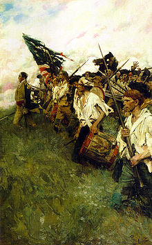 |
US 202/322 just S of Brinton's Bridge/Dilworthtown Rd., 1.6 miles N of US 1, Chadds Ford °N °W |
Roadside | American Revolution, George Washington, Military | |
| Battle of Brandywine Battle of Brandywine The Battle of Brandywine, also known as the Battle of the Brandywine or the Battle of Brandywine Creek, was fought between the American army of Major General George Washington and the British-Hessian army of General Sir William Howe on September 11, 1777. The British defeated the Americans and... |
U.S. 1, at entrance to Brandywine Battlefield Park 39.8227°N 75.5884°W |
Roadside | American Revolution, Military | ||
| Benjamin West Benjamin West Benjamin West, RA was an Anglo-American painter of historical scenes around and after the time of the American War of Independence... |
 |
Pa. 320 in Swarthmore (Missing) °N °W |
Roadside | Artists | |
| Caleb Pusey Caleb Pusey Caleb Pusey, formally Caleb Bartholomew, was a lastmaker and a friend and business partner of William Penn, the founder of the colony of Pennsylvania. Pusey came to the colony to manage Chester Mills for Penn... |
 |
Race St. at City Rd., Upland 39.8516°N 75.55145°W |
City | Professions & Vocations, Religion, William Penn | |
| Casimir Pulaski | U.S. 1 E of Chadds Ford near entrance to Brandywine Battlefield State Park 39.8735°N 75.572°W |
Roadside | American Revolution, Ethnic & Immigration, George Washington, Military | ||
| Chester Chester, Pennsylvania Chester is a city in Delaware County, Pennsylvania, United States, with a population of 33,972 at the 2010 census. Chester is situated on the Delaware River, between the cities of Philadelphia and Wilmington, Delaware.- History :... |
 |
U.S. 322 at NW end of city °N °W |
Roadside | Cities & Towns, Early Settlement, Ethnic & Immigration, Government & Politics, Government & Politics 17th Century, William Penn | |
| Colonial Courthouse 1724 Chester Courthouse The old Chester Courthouse was built in 1724 in Chester, Pennsylvania, to serve as the courthouse for Chester County. Chester County was one of the first three counties in the Province of Pennsylvania set up by William Penn. About 1790 the county seat was moved to West Chester, Pennsylvania and... |
Ave. of the States near 5th St., Chester 39.848°N 75.3599°W |
City | Buildings, Government & Politics, Government & Politics 18th Century | ||
| Colonial Gristmill Newlin Mill Complex The Newlin Mill Complex, a water powered gristmill on the west branch of Chester Creek near Concordville, Pennsylvania, USA, was built in 1704 by Nathaniel and Mary Newlin and operated commercially until 1941. During its three centuries of operation, the mill has been known as the Lower Mill, the... |
U.S. 1, 1 mile E of Concordville 39.8911°N 75.5056°W |
Roadside | Buildings, Business & Industry, Ethnic & Immigration, Mills, Religion | ||
| Darby Friends Burial Ground Darby Meeting The Darby Meeting or Darby Friends Meeting House is located in Darby, Pennsylvania. The first recorded minutes of the meeting are dated July 2, 1684, not long after William Penn landed in nearby Chester to establish the colony of Pennsylvania. The first Friends meeting house in Darby was a log... |
Landsdowne Avenue near 12th Street, Darby °N °W |
Roadside | Religion | ||
| Delaware County Delaware County, Pennsylvania Delaware County is a county located in the U.S. state of Pennsylvania. As of 2010, the population was 558,979, making it Pennsylvania's fifth most populous county, behind Philadelphia, Allegheny, Montgomery, and Bucks counties.... |
 |
Courthouse, Front St. & Veterans Sq., Media 39.9192°N 75.392°W |
City | Government & Politics, Government & Politics 18th Century, William Penn | |
| Dr. George Smith | Off Marvine Ave. at Mansion Dr. on Collenbrook property, Drexel Hill 39.9514°N 75.3211°W |
Roadside | Education, Government & Politics, Government & Politics 19th Century, Medicine & Science, Professions & Vocations | ||
| Dr. Philip Jaisohn Philip Jaisohn Philip Jaisohn was the anglicized name used by Seo Jae-pil, a noted champion for Korea's independence, and the first Korean to become a naturalized citizen of the United States.-Political activist:... |
100 E. Lincoln St., Media 39.9139°N 75.3877°W |
Roadside | Ethnic & Immigration, Government & Politics, Government & Politics 20th Century, Medicine & Science, Professions & Vocations | ||
| Fanny M. Jackson Coppin | Cheyney University campus, off Dilworthtown & Cheyney Rds., Cheyney 39.9327°N 75.5277 °W |
City | African American, Education, Professions & Vocations, Religion, Women, Writers | ||
| Finland Finland Finland , officially the Republic of Finland, is a Nordic country situated in the Fennoscandian region of Northern Europe. It is bordered by Sweden in the west, Norway in the north and Russia in the east, while Estonia lies to its south across the Gulf of Finland.Around 5.4 million people reside... |
 |
Concord Ave. at monument in Chester 39.8496°N 75.378°W |
City | Early Settlement, Ethnic & Immigration | |
| First Friends Meeting | 24th & Chestnut Sts., Chester 39.8695°N 75.3632°W |
City | Religion, William Penn | ||
| Glen Mills Glen Mills, Pennsylvania Glen Mills is an unincorporated community in Concord Township and Middletown Township, Delaware County, Pennsylvania, United States about 17 miles from Philadelphia. Glen Mills is known for its gardens and its golf course. Major offices including Deloitte with a headcount of about 100 people... |
Railroad Station, Glen Mills 39.9204°N 75.4904°W |
Roadside | Business & Industry, Government & Politics, Government & Politics 18th Century, Iron, Mills, Railroads | ||
| Governor Printz Park |  |
At site, 2nd St. & Taylor Ave., Essington 39.8623°N 75.3026°W |
Roadside | Early Settlement, Ethnic & Immigration, Government & Politics 17th Century | |
| Great Trail (The) - Minquas or Susquehanna Indians (PLAQUE) | Rose Valley Rd. (SR 3019), west side, 1/2 mile S of Moylan 39.8985°N 75.3876°W |
Plaque | Early Settlement, Ethnic & Immigration, Native American, Paths & Trails | ||
| Green-Bank |  |
2nd St. near Welsh St., Chester °N °W |
City | Buildings, Houses & Homesteads, Military | |
| Haverford Meeting House | U.S. 30 bypass near Haverford (Missing) °N °W |
City | Houses & Homesteads, Religion | ||
| Hilldale Athletic Club, The (The Darby Daisies) | Cedar Ave. & MacDade Blvd., Yeadon 39.9249°N 75.2565°W |
Roadside | African American, Baseball, Sports | ||
| Ivy Mills | 109 Ivy Mill Road at Polecat Road, Glen Mills 39.8856°N 75.4849°W |
Roadside | Business & Industry, Government & Politics 18th Century, Mills, Religion | ||
| J. Edgar Thomson | Junction SR 2016 (Baltimore Pike) & SR 2027 (Thomson Ave.) just NE of Swarthmore 39.91577°N 75.33737°W |
City | Professions & Vocations, Railroads, Transportation | ||
| John Chadd's House - PLAQUE Chad House The Chad House, which was built by John Wyeth, Jr. for John Chad , is located in Chadds Ford, Pennsylvania. The house was built after 1712 and was added to the National Register of Historic Places on March 11, 1971... |
Lawn of Chadd homestead on PA 100 just N of US 1, Chadds Ford 39.8748°N 75.5917°W |
Plaque | American Revolution, Houses & Homesteads, Military | ||
| John Morton John Morton (politician) John Morton was a farmer, surveyor, and jurist from the Province of Pennsylvania. As a delegate to the Continental Congress during the American Revolution, he provided the swing vote that allowed Pennsylvania to vote in favor of the United States Declaration of Independence... |
 |
420 E. Ridley Ave., Ridley Park, Chester 39.8842°N 75.3185°W |
Roadside | Government & Politics, Government & Politics 18th Century | |
| Joshua Humphrey | SR 1001 (Haverford Ave.) near Haverford 39.9969°N 75.3033°W |
Roadside | Military, Professions & Vocations | ||
| Joshua Pusey Joshua Pusey Joshua Pusey , was an American inventor and an attorney.In 1827, an English pharmacist named John Walker produced his "sulphuretted peroxide strikables," gigantic, yard-long sticks that can be considered the real precursor of today’s match. Small phosphorus matches were first marketed in Germany... |
#11 N. Middletown Rd. (Pa. 352), Lima 39.9236°N 75.4434°W |
Roadside | Business & Industry, Civil War, Invention, Professions & Vocations, Religion | ||
| Lazaretto Quarantine Station Philadelphia Lazaretto The Philadelphia Lazaretto was the first quarantine hospital in the United States, built in 1799, in Tinicum Township, Delaware County, Pennsylvania. The site was originally inhabited by the Lenni Lenape, and then the first Swedish settlers in America... |
99 Wanamaker Ave., at 2nd St. intersection, Essington 39.8622°N 75.2996°W |
Roadside | Ethnic & Immigration, Government & Politics 19th Century, Medicine & Science | ||
| Leiper Railway | SR 2008 (Bullens Ln.) E of Pa. 320, Nether Providence Twp. 39.8763°N 75.3576°W |
Roadside | Railroads, Transportation | ||
| Lower Swedish Cabin Lower Swedish Cabin Lower Swedish Cabin is a historic Swedish-style log cabin on Creek Road in Drexel Hill, Pennsylvania along Darby Creek. The cabin may be one of the oldest log cabins in the United States.-History:... |
At site on Creek Rd., Clifton Heights 39.93818°N 75.30152°W |
City | Early Settlement, Ethnic & Immigration | ||
| Marcus Hook Marcus Hook, Pennsylvania Marcus Hook is a borough in Delaware County, Pennsylvania, United States. The population peaked in the 1920s with 5,324 inhabitants. 2,314 inhabitants were counted at the recent 2000 census. Marcus Hook's current mayor is James Schiliro. The borough calls itself "The Cornerstone of Pennsylvania".... |
U.S. 13 at Municipal Bldg., Marcus Hook 39.819°N 75.4188°W |
Roadside | Business & Industry, Early Settlement, Ethnic & Immigration | ||
| Martin Luther King, Jr. Martin Luther King, Jr. Martin Luther King, Jr. was an American clergyman, activist, and prominent leader in the African-American Civil Rights Movement. He is best known for being an iconic figure in the advancement of civil rights in the United States and around the world, using nonviolent methods following the... |
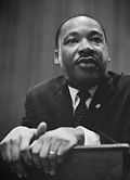 |
Calvary Baptist Church, 1616 W. 2nd St. (Pa. 291), Chester 39.8373°N 75.3779°W |
City | African American, Civil Rights, Religion | |
| Martin Luther King, Jr. Martin Luther King, Jr. Martin Luther King, Jr. was an American clergyman, activist, and prominent leader in the African-American Civil Rights Movement. He is best known for being an iconic figure in the advancement of civil rights in the United States and around the world, using nonviolent methods following the... |
|
Crozer-Chester Medical Center, One Medical Center Blvd., Upland 39.8559°N 75.3709°W |
City | African American, Civil Rights, Religion | |
| Minquas' Path | SR 3019 (Rose Valley Rd.) west side, 1/2 mile S of Moylan 39.8985°N 75.3876°W |
Roadside | Native American, Paths & Trails, Transportation | ||
| Morton Homestead Morton Homestead Morton Homestead is a historic homestead that is part of Morton Homestead State Park at 100 Lincoln Avenue in Prospect Park, Pennsylvania.The homestead was founded in 1654 by Morton Mortenson, a Finnish immigrant, when the area was part of the New Sweden colony. Mortenson's great-grandson, John... |
At site, Pa. 420 at Darby Creek, Prospect Park 39.8774°N 75.3053°W |
Roadside | Early Settlement, Government & Politics, Government & Politics 17th Century | ||
| Morton Mortonson House | Winona St. & Amosland Rd., Norwood (Missing) °N °W |
Roadside | Buildings, Houses & Homesteads | ||
| New Sweden New Sweden New Sweden was a Swedish colony along the Delaware River on the Mid-Atlantic coast of North America from 1638 to 1655. Fort Christina, now in Wilmington, Delaware, was the first settlement. New Sweden included parts of the present-day American states of Delaware, New Jersey, and Pennsylvania.... |
 |
Governor Printz Park, 2nd St. & Taylor Ave., Essington 39.861°N 75.3027°W |
Roadside | Early Settlement, Ethnic & Immigration, Exploration | |
| Old Haverford Friends' Meeting | SR 1005 (E. Eagle Rd.) at St. Denis Ave., Havertown 39.991°N 75.3048°W |
Roadside | Religion, William Penn | ||
| Old Swedish Burial Ground | 3rd St., E of Ave. of the States 39.8472°N 75.3584°W |
City | Ethnic & Immigration, Religion | ||
| Penn Landing William Penn Landing Site The monument at the William Penn Landing Site marks the spot of the first landing of William Penn on the territory of Pennsylvania, on October 28 or 29, 1682... |
SE corner, 2nd (Pa. 291) & Penn Sts., Chester 39.84413°N 75.36143°W |
Roadside | Early Settlement, Exploration, Government & Politics, Government & Politics 17th Century, William Penn | ||
| Pennsylvania Pennsylvania The Commonwealth of Pennsylvania is a U.S. state that is located in the Northeastern and Mid-Atlantic regions of the United States. The state borders Delaware and Maryland to the south, West Virginia to the southwest, Ohio to the west, New York and Ontario, Canada, to the north, and New Jersey to... |
 |
U.S. 202 at state line 39.8392°N 75.5393°W |
Roadside | Government & Politics, Government & Politics 17th Century, William Penn | |
| Pennsylvania Pennsylvania The Commonwealth of Pennsylvania is a U.S. state that is located in the Northeastern and Mid-Atlantic regions of the United States. The state borders Delaware and Maryland to the south, West Virginia to the southwest, Ohio to the west, New York and Ontario, Canada, to the north, and New Jersey to... |
|
U.S. 13 by-pass, approx. 100 feet from state line °N °W |
Roadside | Government & Politics, Government & Politics 17th Century, William Penn | |
| Radnor Meeting House | Junction Pa. 320 & SR SR 1019 (Conestoga Rd.), Ithan, S of St. Davids 40.0303°N 75.364°W |
Roadside | American Revolution, Early Settlement, Houses & Homesteads, Military, Religion | ||
| Rochambeau Route (Narragansett Bay to Yorktown) | U.S. 13 (Morton Ave.) near Melrose Ave., E end of Chester 39.8585°N 75.3525°W |
Roadside | American Revolution, Military, Roads, Transportation | ||
| Sellers Hall | N. side Walnut St. between Copley and Glendale Rds., Upper Darby 39.9569°N 75.2615°W |
Roadside | Buildings, Early Settlement, Medicine & Science, Professions & Vocations | ||
| Springfield Friends Meeting | SR 2009 (Old Sproul & W. Springfield Rds.), Springfield 39.9423°N 75.3471°W |
Roadside | Artists, Buildings, Education, Religion | ||
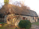
| St. David's Church |  |
SR 1046 (St. David's Rd.) at SR 1017 (Church Rd.) 2 miles SW of Wayne 40.0226°N 75.3994°W |
Roadside | American Revolution, Ethnic & Immigration, Military, Religion | |
| Sun Shipbuilding and Dry Dock Company | intersection of Industrial Hwy. (Rt. 291) & Harrahs Blvd., Chester °N °W |
Roadside | Business & Industry, Labor, Military, Military Post-Civil War, Oil & Gas, Steel | ||
| Thomas Garrett Thomas Garrett Thomas Garrett was an abolitionist and leader in the Underground Railroad movement before the American Civil War.... |
Garrett Rd. & Maple Ave., Drexel Hill 39.9461°N 75.2935°W |
Roadside | African American, Religion, Underground Railroad | ||
| Thomas Massey House Thomas Massey House The Thomas Massey House is a brick and stone colonial house, located on Lawrence Road near West Chester Pike in Broomall, Pennsylvania. The brick section was created by Thomas Massey, a Quaker, in 1696 as an addition to an earlier wooden house. Thomas's son Mordecai Massey likely tore down the... |
467 Lawrence Rd. (SR 1020), .5 mile NE of Pa. 320, Haverford 39.9658°N 75.3518°W |
Roadside | Buildings, Houses & Homesteads | ||
| Tinicum Tinicum Township, Delaware County, Pennsylvania Tinicum Township, more popularly known as "Tinicum Island" or "The Island", a census-designated place and township in Delaware County, Pennsylvania, United States. The population was 4,353 at the 2000 census. Included within the township's boundaries are the communities of Essington and Lester... |
 |
Pa. 291 eastbound, just NE of Essington 39.8671°N 75.2937°W |
Roadside | Early Settlement, Ethnic & Immigration, Government & Politics 17th Century | |
| Washington House | Ave. of the States near 5th St., Chester 39.8481°N 75.3596°W |
City | American Revolution, Buildings, George Washington, Houses & Homesteads | ||
| William Penn (1644-1718) - "Essex House" - PLAQUE | 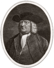 |
102 Penn St., Chester °N °W |
Plaque | Early Settlement, Houses & Homesteads, William Penn |
See also
- List of Pennsylvania state historical markers
- National Register of Historic Places listings in Delaware County, Pennsylvania