

List of Pennsylvania state historical markers in Lebanon County
Encyclopedia
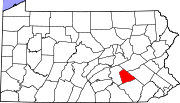
This is intended to be a complete list of the official state historical markers placed in Lebanon County, Pennsylvania
Lebanon County, Pennsylvania
As of the census of 2000, there were 120,327 people and 32,771 families residing in the county. The population density was 332 people per square mile . There were 49,320 housing units at an average density of 136 per square mile...
by the Pennsylvania Historical and Museum Commission
Pennsylvania Historical and Museum Commission
The Pennsylvania Historical and Museum Commission is the governmental agency of the Commonwealth of Pennsylvania responsible for the collection, conservation and interpretation of Pennsylvania's historic heritage...
(PHMC). The locations of the historical markers, as well as the latitude and longitude coordinates as provided by the PHMC's database, are included below when available. There are 32 historical markers located in Lebanon County.
Historical markers
| Marker title | Image | Date dedicated | Location | Marker type | Topics |
|---|---|---|---|---|---|
| Blue Mountain Forts | Jonestown Rd. (old U.S. 22), near intersection with Pa. 934, at Harper Tavern °N °W |
Roadside | Forts, French & Indian War, Government & Politics 18th Century, Military, Native American | ||
| Cornwall Banks | Boyd St., Cornwall, at now abandoned mine 40.26826°N 76.40449°W |
Roadside | Business & Industry, Iron | ||
| Cornwall Furnace | Rexmont Rd. at site in Cornwall 40.27138°N 76.4073°W |
Roadside | Business & Industry, Furnaces, Iron | ||
| Cornwall Furnace | n/a | Boyd St. (old US 322) near Rexmont, Cornwall 40.27135°N 76.40587°W |
Roadside | Business & Industry, Furnaces, Iron | |
| Cornwall Iron Furnace Cornwall Iron Furnace Cornwall Iron Furnace is a designated National Historic Landmark that is administered by the Pennsylvania Historical and Museum Commission in Cornwall, Lebanon County, Pennsylvania in the United States. The furnace was a leading Pennsylvania iron producer from 1742 until it was shut down in 1883... |
Rts. 322 & 419, near Quentin, W of Cornwall 40.5158°N 76.68°W |
Roadside | American Revolution, Furnaces, Iron | ||
| Fort Swatara | Pa. 72, about a mile N of Lickdale 40.46456°N 76.51436°W |
Roadside | Early Settlement, Forts, French & Indian War, Military, Native American | ||
| Fort Zeller | PA 419 (Main St.) at Ft. Zeller Rd., Newmanstown 40.34505°N 76.22298°W |
Roadside | Forts, French & Indian War, Military, Native American | ||
| Grubb's First Forge | Boyd St. & Gold Rd., Miners' Village, Cornwall 40.26727°N 76.40213°W |
City | Business & Industry, Iron | ||
| Indiantown Fort Indiantown Gap Fort Indiantown Gap, also referred to as "The Gap" or "FIG", is a census-designated place and U.S. Army post primarily located in Lebanon County, Pennsylvania. A portion of the installation is located in eastern Dauphin County... |
Fisher Ave. (PA 934), just S of old US 22, Harper Tavern 40.40153°N 76.57581°W |
Roadside | Early Settlement, Native American | ||
| Indiantown Gap | n/a | US 22 NE of Harrisburg, E of Rt. 743 intersection °N °W |
Roadside | Cities & Towns, Military, Native American | |
| Indiantown Gap Military Reservation | SR 4019, 1.3 miles N of U.S. 22 approaching Fort Indiantown Gap, Harper Tavern 40.42317°N 76.57598°W |
Roadside | Military, Military Post-Civil War | ||
| Indiantown Gap Military Reservation | old US 22 S of Fort Indiantown Gap, near PA 934, Harper Tavern 40.40676°N 76.58062°W |
Roadside | Military, Military Post-Civil War | ||
| Jacob Albright Jacob Albright Jacob Albright was an American Christian leader, founder of Albright's People which was officially named the Evangelical Association in 1816... |
Pa. 897 near Main & Shad Sts., Kleinfeltersville 40.30244°N 76.24527°W |
City | Ethnic & Immigration, Religion | ||
| James Lick James Lick James Lick was an American carpenter, piano builder, land baron, and patron of the sciences. At the time of his death, he was the wealthiest man in California, and left the majority of his estate to social and scientific causes.-Early years:James Lick was born in Stumpstown Pennsylvania on August... |
U.S. 22 near junction Pa. 343 just S of Fredericksburg 40.43907°N 76.43071°W |
Roadside | Medicine & Science, Professions & Vocations | ||
| John Walter John Walter John Walter , founder of The Times newspaper, London, was born in London and educated at Merchant Taylors' School, Northwood.... |
Old U.S. 22 W of Ono at cemetery 40.40238°N 76.54155°W |
Roadside | Music & Theater, Publishing, Religion | ||
| Lebanon County | County-Municipal Bldg., 400 S. 8th St., Lebanon 40.33258°N 76.42386°W |
City | Agriculture, Government & Politics, Government & Politics 19th Century, Religion | ||
| Lindley Murray Lindley Murray Lindley Murray , grammarian, was born in a house near his father's mill, just north of Harper Tavern in Lebanon County, Pennsylvania, 18 miles northeast of Harrisburg. He was the eldest son of Robert Murray, the Quaker merchant, and Mary Lindley Murray, whose home was on a hill in Manhattan on what... |
U.S. 22, 18 miles NE of Harrisburg, E of junction Pa. 934 just N of Harper Tavern 40.40183°N 76.57599°W |
Roadside | Education, Mills, Professions & Vocations, Writers | ||
| Lindley Murray Lindley Murray Lindley Murray , grammarian, was born in a house near his father's mill, just north of Harper Tavern in Lebanon County, Pennsylvania, 18 miles northeast of Harrisburg. He was the eldest son of Robert Murray, the Quaker merchant, and Mary Lindley Murray, whose home was on a hill in Manhattan on what... |
Intersection Pa. 934 & old U.S. 22, Harper Tavern 40.40456°N 76.57726°W |
Roadside | Education, Mills, Professions & Vocations, Writers | ||
| Lindley Murray Lindley Murray Lindley Murray , grammarian, was born in a house near his father's mill, just north of Harper Tavern in Lebanon County, Pennsylvania, 18 miles northeast of Harrisburg. He was the eldest son of Robert Murray, the Quaker merchant, and Mary Lindley Murray, whose home was on a hill in Manhattan on what... |
Pa. 934, .2 mile N of U.S. 22, Harper Tavern 40.40979°N 76.58159°W |
Roadside | Education, Mills, Professions & Vocations, Writers | ||
| One Red Rose - PLAQUE | n/a | On church at old US 422 between SR 2019 & Berks County line, Myerstown 40.38225°N 76.26309°W |
Plaque | Religion | |
| Pennsylvania Chatauqua, The | Pa. Route 117 and Carnegie Ave., Mt. Gretna 40.24829°N 76.47127°W |
Roadside | Artists, Education, Medicine & Science, Religion | ||
| Reed's Fort | Allentown Blvd. / Wm. Penn Hwy. (US 22), E of Fisher Ave. (PA 934), just W of Ono 40.40699°N 76.55858°W |
Roadside | Forts, French & Indian War, Military, Native American | ||
| Sattazahn Lutheran Church | At church on Green Point School Rd., N of Pa. 443 near Murray 40.49862°N 76.53813°W |
Roadside | American Revolution, Buildings, Early Settlement, Ethnic & Immigration, Military, Religion | ||
| Schaefferstown Water Company | Fountain Park at S. Market St. & Sheep Hill Rd., Schaefferstown 40.29562°N 76.29399°W |
Roadside | Business & Industry, Early Settlement, Environment | ||
| Swatara Gap | PA 72, 2 miles N of Lickdale, near Inwood 40.47563°N 76.52138°W |
Roadside | Early Settlement, Forts, French & Indian War, Military, Native American, Paths & Trails, Transportation | ||
| Transporation Corps Unit Training Center | Fisher Ave., near Quartermaster Rd., Ft. Indiantown Gap, Annville °N °W |
Roadside | Education, Military, Military Post-Civil War, Transportation | ||
| Tulpehocken Evangelical and Reformed Church | Benjamin Franklin Hwy. / E Lincoln Ave (US 422) near E Main Ave., 3 miles E of Myerstown °N °W |
Roadside | Buildings, Religion | ||
| Union Canal Union Canal Union Canal is a placename:* Union Canal , a canal in Scotland between Edinburgh and Falkirk* Union Canal , a nineteenth century canal in Pennsylvania, United States, closed in 1880... |
U.S. 422, 1 mile W of Myerstown 40.36892°N 76.33415°W |
Roadside | Canals, Navigation, Transportation | ||
| Union Canal Union Canal Union Canal is a placename:* Union Canal , a canal in Scotland between Edinburgh and Falkirk* Union Canal , a nineteenth century canal in Pennsylvania, United States, closed in 1880... |
PA 72 just S of PA 443 junction, near iron bridge, 4 miles NW of Lickdale 40.47981°N 76.5322°W |
Roadside | Canals, Navigation, Transportation | ||
| Union Canal Union Canal Union Canal is a placename:* Union Canal , a canal in Scotland between Edinburgh and Falkirk* Union Canal , a nineteenth century canal in Pennsylvania, United States, closed in 1880... |
Pa. 72, 5 miles NW of Lebanon 40.39541°N 76.48622°W |
Roadside | Canals, Navigation, Transportation | ||
| Union Canal Tunnel | At site on Tunnel Hill Rd. (SR 4001) near W Maple St. / Ebenezer Rd.(PA 72) junction, NW of Lebanon 40.34983°N 76.46015°W |
Roadside | Canals, Navigation, Transportation | ||
| Union Forge | n/a | SR 1020 just E of Pa. 72, Lickdale 40.45296°N 76.51106°W |
Roadside | Business & Industry, Coal, Iron |
See also
- List of Pennsylvania state historical markers
- National Register of Historic Places listings in Lebanon County, PennsylvaniaNational Register of Historic Places listings in Lebanon County, PennsylvaniaThis is a list of the National Register of Historic Places listings in Lebanon County, Pennsylvania.This is intended to be a complete list of the properties and districts on the National Register of Historic Places in Lebanon County, Pennsylvania, United States...