

List of Pennsylvania state historical markers in Montgomery County
Encyclopedia

This is intended to be a complete list of the official state historical markers placed in Montgomery County, Pennsylvania
Montgomery County, Pennsylvania
Montgomery County is a county located in the U.S. state of Pennsylvania, in the United States. As of 2010, the population was 799,874, making it the third most populous county in Pennsylvania . The county seat is Norristown.The county was created on September 10, 1784, out of land originally part...
by the Pennsylvania Historical and Museum Commission
Pennsylvania Historical and Museum Commission
The Pennsylvania Historical and Museum Commission is the governmental agency of the Commonwealth of Pennsylvania responsible for the collection, conservation and interpretation of Pennsylvania's historic heritage...
(PHMC). The locations of the historical markers, as well as the latitude and longitude coordinates as provided by the PHMC's database, are included below when available. There are 60 historical markers located in Montgomery County.
Historical markers
| Marker title | Image | Date dedicated | Location | Marker type | Topics |
|---|---|---|---|---|---|
| Abington Presbyterian Church | Old York & Susquehanna Sts., Abington 40.11418°N 75.1219°W |
City | Religion | ||
| Abolition Hall | 4006 Butler Pike, Plymouth Meeting 40.10303°N 75.27813°W |
Roadside | African American, Buildings, Underground Railroad | ||
| Augustus Lutheran Church Augustus Lutheran Church Augustus Lutheran Church, built during 1743-1745 in Trappe, Pennsylvania, is the oldest unchanged Lutheran church building in the United States in continuous use by the same congregation.... |
Main St. (old U.S. 422) in Trappe 40.20115°N 75.4812°W |
Roadside | Religion | ||
| Baldwin School, The | 701 Montgomery Ave., Bryn Mawr °N °W |
Roadside | Buildings, Education, Railroads | ||
| Bert Bell Bert Bell De Benneville "Bert" Bell was the National Football League commissioner from 1946 until his death in 1959. As commissioner, he helped chart a path for the NFL to facilitate its rise in becoming the most popular sports attraction in the United States... |
224-226 Haverford Ave., Narbeth 40.00537°N 75.26103°W |
City | Football, Sports | ||
| Beth Sholom Synagogue Beth Sholom Synagogue Beth Sholom Congregation is a Conservative synagogue located in the Philadelphia suburb of Elkins Park, Pennsylvania. It is the only synagogue designed by famed architect Frank Lloyd Wright... |
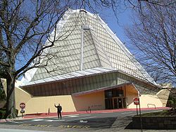 |
8231 Old York Rd., Elkins Park 40.0818°N 75.1268°W |
City | Buildings, Religion | |
| Betzwood Motion Picture Studio | Near Route 363 and Route 422 expressway, Norristown °N °W |
City | Business & Industry, Invention, Motion Pictures & Television | ||
| Bryn Athyn Cathedral Bryn Athyn Cathedral Bryn Athyn Cathedral is the episcopal seat of The General Church of the New Jerusalem, a denomination of "The New Church." The main building is of the Early Gothic style, while the adjoining structures are of a transitional period reflective of a combination of both Gothic and Norman styles... |
 |
Pa. 232 in Bryn Athyn at Cathedral °N °W |
Roadside | Religion | |
| Bryn Mawr Summer School for Women Workers in Industry | Bryn Mawr Campus, Corner of Morris Road and Yarrow Streets 40.0241°N 75.31388°W |
Roadside | African American, Civil Rights, Education, Ethnic & Immigration, Labor, Women | ||
| Camp William Penn Camp William Penn Camp William Penn was a Union Army training camp located in Cheltenham, Pennsylvania from 1863 to 1865, notable for being the first training grounds dedicated to African American troops who enlisted in the United States Army during the American Civil War... |
7322 Sycamore Ave., LaMott 40.06635°N 75.1423°W |
Roadside | African American, Civil War, Military | ||
| Charles Thomson Charles Thomson Charles Thomson was a Patriot leader in Philadelphia during the American Revolution and the secretary of the Continental Congress throughout its existence.-Biography:... |
 |
SR 3034 (Morris Ave. at Harriton Rd.), NE, of Bryn Mawr (Missing) °N °W |
Roadside | Ethnic & Immigration, Government & Politics, Government & Politics 18th Century | |
| Crooked Billet | Meadowbrook Ave. at Crooked Billet Elem. School in Hatboro °N °W |
Roadside | American Revolution, Military, Inns & Taverns | ||
| Cyrus H. K. Curtis (1850-1933) |  |
1250 W Church Rd., Wyncote (SR73) 40.08693°N 75.14942°W |
Roadside | Entrepreneurs, Environment, Publishing | |
| Early Grist Mill | Pa. 320 at Gulph Mills (Missing) °N °W |
City | Buildings, Business & Industry, Mills | ||
| Early Tavern | General Wayne Inn, 625 Montgomery Ave., Narbeth °N °W |
Roadside | Business & Industry, George Washington, Inns & Taverns, William Penn | ||
| Edward Hector | Intersection SR 3016 & 3013 (Fayette & Hector Sts.), Conshohocken 40.07328°N 75.30668°W |
Roadside | African American, American Revolution, Military | ||
| Falkner Swamp Reformed Church | Swamp Pike (county highway, Limerick to Gilbertsville), .5 mile SE of New Hanover 40.2961°N 75.58013°W |
Roadside | Buildings, Ethnic & Immigration, Religion | ||
| First Iron Bridge | SE corner, High & York Sts., Pottstown 40.24588°N 75.65263°W |
City | Bridges, Iron, Railroads, Transportation | ||
| Frank N.D. Buchman | 772 Main St. (Pa. 29), Pennsburg °N °W |
Roadside | Professions & Vocations, Religion | ||
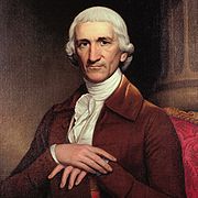
| Frederick A. C. Muhlenberg (1750-1801) | 151 W Main St., Trappe °N °W |
Roadside | Government & Politics, Government & Politics 18th Century, Religion | ||
| Gen. Andrew Porter | W. Main & Selma Sts., Norristown 40.12258°N 75.36063°W |
Roadside | American Revolution, Military | ||
| Graeme Park Graeme Park Graeme Park is an historic site in Horsham, Montgomery County. It is owned by the Pennsylvania Historical and Museum Commission and operated by the non-profit group, The Friends of Graeme Park. It is the only surviving residence of a colonial-era Pennsylvania governor... |
 |
n/a | At site, SR 2038 (County Line Road), 1 mile NW of Pa. 611, Hatboro (Missing) °N °W |
Roadside | Environment, Government & Politics 18th Century |
| Gulph Mills Encampment | Pa. 320 near intersection SR 3030 at Gulph Mills (Missing) °N °W |
City | American Revolution, Military | ||
| Gulph Mills Village | Intersection Pa. 320 & SR 3039 (Gulph Rd.), Gulph Mills 40.06293°N 75.34125°W |
City | Buildings, Houses & Homesteads, Inns & Taverns | ||
| Harold F. Pitcairn | Buck & Paper Mill Rds., Bryn Athyn 40.132°N 75.05835°W |
Roadside | Invention, Medicine & Science, Professions & Vocations, Transportation | ||
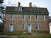
| Harriton Harriton House Harriton House is an historic house on Pennsylvania's Main Line, most famously the residence of Charles Thomson, the secretary of the Continental Congress... |
SR 3034 (Morris Ave. at Harriton Rd.), NE of Bryn Mawr °N °W |
City | Government & Politics, Government & Politics 18th Century, Houses & Homesteads | ||
| Hope Lodge |  |
At site, Old Bethlehem Pike (SR 2018), Fort Washington 40.12495°N 75.21753°W |
Roadside | Buildings, Houses & Homesteads | |
| James A. Bland James A. Bland James Alan Bland , also known as Jimmy Bland, was an African American musician and song writer.-Biography:... |
 |
Pa. 23 (Conshohocken State Rd.), Bala Cynwyd °N °W |
City | African American, Music & Theater, Performers | |
| John Dickinson John Dickinson (delegate) John Dickinson was an American lawyer and politician from Philadelphia, Pennsylvania and Wilmington, Delaware. He was a militia officer during the American Revolution, a Continental Congressman from Pennsylvania and Delaware, a delegate to the U.S. Constitutional Convention of 1787, President of... |
Montgomery Avenue & Meetinghouse Lane, Merion (MISSING) °N °W |
Roadside | American Revolution, Government & Politics 18th Century, Military | ||
| John F. Hartranft John F. Hartranft John Frederick Hartranft was the 17th Governor of Pennsylvania from 1873 to 1879 and a Union Major General who received the Medal of Honor for his actions during the American Civil War.-Early life and career:... |
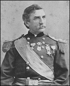 |
Sanatoga Rd., SW of Fagleysville 40.27137°N 75.57325°W |
Roadside | Civil War, Government & Politics, Government & Politics 19th Century, Governors, Military | |
| John F. Hartranft John F. Hartranft John Frederick Hartranft was the 17th Governor of Pennsylvania from 1873 to 1879 and a Union Major General who received the Medal of Honor for his actions during the American Civil War.-Early life and career:... |
|
SR 4031 (High St., old U.S. 422), Sanatoga (Missing) °N °W |
Roadside | Civil War, Government & Politics, Government & Politics 19th Century, Governors, Military | |
| Keith House Keith House-Washington's Headquarters The Keith House, also known as Washington's Headquarters or Headquarters Farm, is a historic house in Upper Makefield Township, Bucks County in the U.S. state of Pennsylvania... |
At Graeme Park, County Line Rd., 1 mile NW of Pa. 611, Hatboro 40.21854°N 75.15049°W |
Roadside | Government & Politics, Government & Politics 18th Century, Houses & Homesteads | ||
| Lafayette | 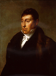 |
801 Ridge Pike, Barren Hill, E of Conshohocken 40.7823°N 75.24968°W |
Roadside | American Revolution, Military | |
| Lucretia C. Mott Lucretia Mott Lucretia Coffin Mott was an American Quaker, abolitionist, social reformer, and proponent of women's rights.- Early life and education:... |
Pa. 611 N of Cheltenham Ave., Elkins Park 40.06442°N 75.13548°W |
Roadside | Civil Rights, Government & Politics, Government & Politics 19th Century, Religion, Underground Railroad, Women | ||
| Merion Friends Meeting Merion Friends Meeting House Merion Friends Meeting House in Merion Station, Pennsylvania is the second oldest Friends meeting house in the United states and remains the place of worship of the of The Religious Society of Friends . The meeting was founded by the first known group of Welsh settlers in the Americas... |
651 Montgomery Ave., Narberth 40.0093°N 75.25418°W |
City | Buildings, Ethnic & Immigration, Religion, William Penn | ||
| Mill Grove Mill Grove Mill Grove is a historic stone house in Audubon, Pennsylvania on the National Register of Historic Places. It is the first home in America of painter John James Audubon for which the community is named. It is maintained as a museum and wildlife sanctuary by Montgomery County.Mill Grove was owned... |
.jpg) |
Entrance to Audubon Wildlife Sanctuary, Audubon & Pawlings Rds. (SR 4041 & 4004), Audubon 40.12337°N 75.43708°W |
Roadside | Artists, Buildings, Environment, Mansions & Manors, Writers | |
| Muhlenberg Home | E. 7th Ave., .3 mile from Main St. (old U.S. 422), Trappe (Missing) 40.1963°N 75.46987°W |
Roadside | Education, Government & Politics, Government & Politics 18th Century | ||
| Muhlenberg House | 201 Main St. (old U.S. 422), Trappe °N °W |
City | American Revolution, Religion | ||
| New Goschenhoppen Reformed Church | SR 1042 (Church Rd.), W of East Greenville (MISSING) °N °W |
Roadside | Buildings, Religion | ||
| New Hanover Lutheran Church | Swamp Pike (county highway), at Lutheran Rd., near Gilbertsville Golf Course, .2 mile SE of New Hanover 40.29793°N 75.58173°W |
Roadside | Buildings, Ethnic & Immigration, Religion | ||
| Pennsylvania School of Horticulture for Women, The | 580 Meetinghouse Road, Ambler °N °W |
Roadside | Agriculture, Education, Military, Women | ||
| Pennypacker's Mill & Mansion | At site, Skippack Pike (PA 73) and Haldeman Rd., Schwenksville 40.25267°N 75.45862°W |
Roadside | George Washington, Government & Politics, Government & Politics 18th Century, Governors | ||
| Perkiomen Bridge Perkiomen Bridge The Perkiomen Bridge, originally built 1798-99 and widened in 1928, is one of the oldest stone arch bridges in the United States still in use. It crosses Perkiomen Creek near Collegeville, Pennsylvania. The bridge's six semi-circular arches cover a total of over . The longest arch spans .... |
E Main St. / Ridge Pike (SR 4031 / old U.S. 422) at bridge, E end of Collegeville 40.18428°N 75.44717°W |
Roadside | Bridges, Transportation | ||
| Philo T. Farnsworth (1906-1971) | 1260 E Mermaid Lane, Wyndmoor 40.08318°N 75.18202°W |
City | Business & Industry, Invention | ||
| Plymouth Friends Meetinghouse Plymouth Friends Meetinghouse Plymouth Friends Meetinghouse is a historic Quaker meeting house at the corner of Germantown and Butler Pikes in Plymouth Meeting, Pennsylvania.It was built in 1708 and added to the National Register in 1971.... |
Germantown Pike (old U.S. 422) & Butler Pike at Plymouth Meeting 40.10272°N 75.27882°W |
Roadside | African American, American Revolution, Buildings, George Washington, Religion | ||
| Porter Home | U.S. 422 at Norristown (Missing) °N °W |
Roadside | American Revolution, Government & Politics 19th Century, Military | ||
| Pottsgrove Manor | At site, 100 W. King St. , Pottstown 40.24788°N 75.65995°W |
Roadside | Buildings, Business & Industry, Iron, Mansions & Manors | ||
| Rittenhouse Farm | Pa. 363 E of Eagleville, intersection SR 3009 (Ridge Pike) & 3002 (Trooper Rd.), Norristown 40.14187°N 75.38915°W |
Roadside | Medicine & Science, Professions & Vocations | ||
| Rittenhouse Farm | Germantown Pike (former U.S. 422) at Valley Forge Medical Ctr., 6 miles SE of Collegeville (Missing) °N °W |
Roadside | Medicine & Science, Professions & Vocations | ||
| Selma | 1301 W. Airy St., Norristown 40.12328°N 75.36°W |
Roadside | American Revolution, Military | ||
| St. Paul's Episcopal Church St. Paul's Episcopal Church (Elkins Park, Pennsylvania) St. Paul's Episcopal Church is a historic church at Old York and Ashbourne Roads in Elkins Park, Pennsylvania.It was built in 1861 and added to the National Register of Historic Places in 1982.-References:... |
Old York Rd. (PA 611) at Asbourne Rd., Elkins Park 40.07148°N 75.13347°W |
Roadside | Buildings, Civil War, Religion | ||
| St. Peter's Church | Church Rd., off Germantown Pike (old U.S. 422) 5 miles E of Norristown 40.08287°N 75.25095°W |
Roadside | American Revolution, Buildings, Religion | ||
| Thomas Rowland & Sons Shovel Works | 300 Ashbourne Rd., Cheltenham °N °W |
Roadside | Business & Industry, Mills | ||
| Timothy Matlack Timothy Matlack Timothy Matlack was a merchant, surveyor, architect, statesman, and patriot in the American Revolution. A delegate from Pennsylvania to the Second Continental Congress in 1780, he emerged during the Revolutionary period as one of Pennsylvania's most provocative and influential political... |
 |
Pawlings Rd. (SR 4004) near Audubon Rd. (SR 4041) at Audubon 40.122°N 75.43975°W |
Roadside | American Revolution, Government & Politics, Government & Politics 18th Century, Religion | |
| Village of La Mott | PA 309 (Cheltenham Ave.) just NW of Pa. 611 °N °W |
Roadside | African American, Cities & Towns, Civil War, Military, William Penn | ||
| Wall House (The Ivy) Wall House The Richard Wall house, built 1682, is "the oldest house in Pennsylvania which has had continuous family residency". It is listed in the National Register of Historic Places as "Wall House" also known as "The Ivy". Having hosted religious meetings and weddings, the house is also among the earliest... |
Wall Park Dr. & Church Rd., Elkins Park °N °W |
Roadside | Houses & Homesteads, Religion, William Penn | ||
| Whitemarsh |  |
SR 2027 (Pennsylvania Ave.) just E of Pa. 309, SE of Fort Washington 40.12425°N 75.19247°W |
Roadside | American Revolution, George Washington, Houses & Homesteads, Military | |
| William B. T. Trego William B. T. Trego William Brooke Thomas Trego was an American painter best known for his historical military subjects, in particular scenes of the American Revolution and Civil War.- Biography :... (1858-1909) |
509 E Montgomery Ave., North Wales 40.21345°N 75.2748°W |
City | Artists, Military | ||
| Winfield S. Hancock |  |
Pa. 309 S of Montgomeryville °N °W |
Roadside | Civil War, Military | |
| Woodrow Wilson Woodrow Wilson Thomas Woodrow Wilson was the 28th President of the United States, from 1913 to 1921. A leader of the Progressive Movement, he served as President of Princeton University from 1902 to 1910, and then as the Governor of New Jersey from 1911 to 1913... |
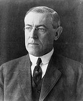 |
New Gulph Rd. at entrance to college, near Caversham Rd., Bryn Mawr 40.0282°N 75.31242°W |
City | Education, Government & Politics, Government & Politics 19th Century, Government & Politics 20th Century |
See also
- List of Pennsylvania state historical markers
- National Register of Historic Places listings in Montgomery County, Pennsylvania