

List of Pennsylvania state historical markers in Westmoreland County
Encyclopedia
This is intended to be a complete list of the official state historical markers placed in Westmoreland County, Pennsylvania
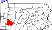
Westmoreland County, Pennsylvania
-Demographics:As of the census of 2000, there were 369,993 people, 149,813 households, and 104,569 families residing in the county. The population density was 361 people per square mile . There were 161,058 housing units at an average density of 157 per square mile...
by the Pennsylvania Historical and Museum Commission
Pennsylvania Historical and Museum Commission
The Pennsylvania Historical and Museum Commission is the governmental agency of the Commonwealth of Pennsylvania responsible for the collection, conservation and interpretation of Pennsylvania's historic heritage...
(PHMC). The locations of the historical markers, as well as the latitude and longitude coordinates as provided by the PHMC's database, are included below when available. There are 42 historical markers located in Westmoreland County.
Historical markers
| Marker title | Image | Date dedicated | Location | Marker type | Topics |
|---|---|---|---|---|---|
| Arthur St. Clair Arthur St. Clair Arthur St. Clair was an American soldier and politician. Born in Scotland, he served in the British Army during the French and Indian War before settling in Pennsylvania, where he held local office... |
U.S. 30, 6.5 miles NW of Ligonier 40.2854°N 79.3209°W |
Roadside | American Revolution, Government & Politics, Government & Politics 18th Century, Military | ||
| Arthur St. Clair (1737-1818) Arthur St. Clair Arthur St. Clair was an American soldier and politician. Born in Scotland, he served in the British Army during the French and Indian War before settling in Pennsylvania, where he held local office... |
St. Clair Park, N. Main St. near E Otterman St., Greensburg °N °W |
Roadside | American Revolution, Ethnic & Immigration, Government & Politics, Government & Politics 18th Century, Military | ||
| Brush Creek Salem Church | U.S. 30 near Adamsburg, near Bush Run Markers (Missing) °N °W |
Roadside | Religion | ||
| Bullet's Defeat | Old Forbes Road, SR1010 50, Ligonier °N °W |
Roadside | Forts, French & Indian War, Military | ||
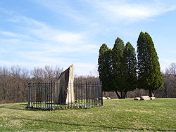
| Bushy Run Battle of Bushy Run The Battle of Bushy Run was fought on August 5-6, 1763, in western Pennsylvania, between a British column under the command of Colonel Henry Bouquet and a combined force of Delaware, Shawnee, Mingo, and Huron warriors. This action occurred during Pontiac's Rebellion... |
U.S. 30 at Lowry Ave., S end of Jeanette 40.31087°N 79.61892°W |
Roadside | Early Settlement, Forts, French & Indian War, Military, Native American, Transportation | ||
| Bushy Run Battle of Bushy Run The Battle of Bushy Run was fought on August 5-6, 1763, in western Pennsylvania, between a British column under the command of Colonel Henry Bouquet and a combined force of Delaware, Shawnee, Mingo, and Huron warriors. This action occurred during Pontiac's Rebellion... |
 |
Pa. 66 at Pittsburgh St. (old U.S. 22), Delmont 40.41412°N 79.57252°W |
Roadside | Early Settlement, Forts, French & Indian War, Military, Native American | |
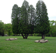
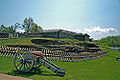
| Bushy Run Battlefield Bushy Run Battlefield Bushy Run Battlefield Park is a historical park that was operated by the Pennsylvania Historical and Museum Commission, on , in Penn Township, Westmoreland County, Pennsylvania in the United States. It was the site of the Battle of Bushy Run fought on August 5 - 6, 1763 during the Pontiac's Rebellion... |
 |
At site, Pa. 993, 1 mile E of Harrison City 40.35577°N 79.6256°W |
Roadside | Forts, French & Indian War, Military, Native American | |
| Christian B. Anfinen Christian B. Anfinsen Christian Boehmer Anfinsen, Jr. was an American biochemist. He shared the 1972 Nobel Prize in Chemistry with Stanford Moore and William Howard Stein for work on ribonuclease, especially concerning the connection between the amino acid sequence and the biologically active conformation... |
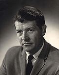 |
3rd & Donner Avenues, Monessen °N °W |
City | Education, Invention, Medicine & Science, Professions & Vocations | |
| Colonel Edward Cook | Intersection near Rehoboth Church °N °W |
Roadside | Early Settlement, Government & Politics, Government & Politics 18th Century, Military, Professions & Vocations, Whiskey Rebellion | ||
| Dagworthy's Camp | U.S. 30, 8.3 miles E of Greensburg (Missing) °N °W |
Roadside | Forts, French & Indian War, Medicine & Science, Military | ||
| Darr Mine Disaster Darr Mine Disaster The Darr Mine Disaster at Van Meter, Rostraver Township, Westmoreland County, Pennsylvania, near Smithton, killed 239 men and boys on December 19, 1907. It ranks as the worst coal mining disaster in Pennsylvania history... |
Olive Branch Cemetery, Pa. 981 between Pa. 51 and Smithton 40.15452°N 79.75562°W |
Roadside | Business & Industry, Coal, Ethnic & Immigration, Labor | ||
| Fanny Sellins Fannie Sellins Fannie Sellins was an American union organizer.Born Fanny Mooney in New Orleans, Louisiana, she married Charles Sellins in St. Louis, Missouri. After his death she worked in a garment factory to support her four children. She helped to organize Local # 67 of the International Ladies' Garment... |
Front of Union Cemetery, Pa. 366, Arnold 40.5821°N 79.75783°W |
Roadside | Labor, Women | ||
| Forbes Road Forbes Road The Forbes Road was a historic military roadway in what was then British America, that was constructed in 1758 from Carlisle, Pennsylvania, to the French Fort Duquesne at the junction of the Allegheny and Monongahela rivers in what is now downtown Pittsburgh... |
U.S. 22, 1.2 miles E of Murrysville (Missing) °N °W |
Roadside | French & Indian War, George Washington, Military, Roads | ||
| Forbes Road Forbes Road The Forbes Road was a historic military roadway in what was then British America, that was constructed in 1758 from Carlisle, Pennsylvania, to the French Fort Duquesne at the junction of the Allegheny and Monongahela rivers in what is now downtown Pittsburgh... |
Murrysville °N °W |
Roadside | French & Indian War, George Washington, Military, Roads | ||
| Forbes Road Forbes Road The Forbes Road was a historic military roadway in what was then British America, that was constructed in 1758 from Carlisle, Pennsylvania, to the French Fort Duquesne at the junction of the Allegheny and Monongahela rivers in what is now downtown Pittsburgh... |
n/a | U.S. 22, 1.2 miles E of Murrysville 40.42308°N 79.66362°W |
Roadside | French & Indian War, George Washington, Military, Roads | |
| Forbes Road, 1758, Fort Bedford to Fort Duquesne - 12 Mile Run Encampment (PLAQUE) | Rt. 30 next to Latrobe Airport runway (?) °N °W |
Plaque | French & Indian War, Military, Roads | ||
| Forbes Road, 1758, Fort Bedford to Fort Duquesne - Fort Ligonier (PLAQUE) | 301 E Main St., hlaf block from public sq., Ligonier °N °W |
Plaque | Forts, French & Indian War, Military, Roads | ||
| Forbes Road, 1758, Fort Bedford to Fort Duquesne - Turtle Creek Defile (PLAQUE) | Rt. 22 at Priority Ln., at Post Office, Murrysville °N °W |
Plaque | French & Indian War, George Washington, Military, Roads | ||
| Fort Allen Fort Allen Fort Allen was a structure, built in 1774 in Hempfield Township, Pennsylvania, for protection from Indian attacks.Roughly 800 pioneer settlers in Hempfield, a large number of them German, had petitioned the state for aid and protection from Indian attacks. In response to that, Fort Allen was built... |
Pa. 136 at SR 3097, Hempfield Twp, SW of Greensburg 40.28348°N 79.5924°W |
Roadside | American Revolution, Early Settlement, Ethnic & Immigration, Forts, Military, Native American | ||
| Fort Allen - PLAQUE Fort Allen Fort Allen was a structure, built in 1774 in Hempfield Township, Pennsylvania, for protection from Indian attacks.Roughly 800 pioneer settlers in Hempfield, a large number of them German, had petitioned the state for aid and protection from Indian attacks. In response to that, Fort Allen was built... |
At church, SR 3097 & St. Johns Rd., .5 mile S of PA 136 SW of Greensburg 40.27905°N 79.59163°W |
Plaque | American Revolution, Forts, French & Indian War, Military | ||
| Fort Ligonier Fort Ligonier Fort Ligonier is a British fortification from the French and Indian War located in Ligonier, Pennsylvania, United States. The fort served as a staging area for the Forbes Expedition of 1758. During the eight years of its existence as a garrison, Fort Ligonier was never taken by an enemy... |
 |
Main & Market Sts., Ligonier 40.24123°N 79.23505°W |
Roadside | Forts, French & Indian War, Military, Native American | |
| Hannastown Hannastown, Pennsylvania Hannastown is an unincorporated community and important historical and archaeological site located in Hempfield Township, Westmoreland County, Pennsylvania. Although the village is not tracked by the Census Bureau, it has been assigned the ZIP code 15635.... |
U.S. 119 at SR 1032 (Forbes Rd.) N of Greensburg (Missing) °N °W |
Roadside | American Revolution, Government & Politics, Government & Politics 18th Century, Native American | ||
| Henry Clay Frick Henry Clay Frick Henry Clay Frick was an American industrialist, financier, and art patron. He founded the H. C. Frick & Company coke manufacturing company, was chairman of the Carnegie Steel Company, and played a major role in the formation of the giant U.S. Steel steel manufacturing concern... |
 |
Pa. 819 at SR 3089 (old U.S. 119) N end of Scottdale °N °W |
Roadside | Business & Industry, Coal, Professions & Vocations, Steel | |
| John W. Geary John W. Geary John White Geary was an American lawyer, politician, Freemason, and a Union general in the American Civil War... |
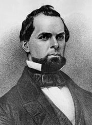 |
S. Diamond St. & Union Alley, Mount Pleasant Veterans Park °N °W |
Roadside | Civil War, Government & Politics, Government & Politics 19th Century, Governors, Military | |
| Johnston House | U.S. 30, 7 miles NW of Ligonier °N °W |
Roadside | Buildings, Government & Politics, Government & Politics 19th Century, Governors, Houses & Homesteads | ||
| Loyalhanning | U.S. 30 just SE of Ligonier 40.23707°N 79.23042°W |
Roadside | Early Settlement, Native American | ||
| Mammoth Mine Explosion | St. John's Cemetery, along Rt. 819, Scottdale 40.09303°N 79.6024°W |
Roadside | Business & Industry, Labor | ||
| Morewood Massacre | Rt. 119 overpass on Rt. 981 (Moorewood Rd.), E Huntington Twp. °N °W |
Roadside | Business & Industry, Labor | ||
| Murrysville Gas Well | US 22, between Trafford Rd. and Reed Blvd., Murrysville 40.42702°N 79.69762°W |
Roadside | Business & Industry, Oil & Gas | ||
| Norvelt Norvelt, Pennsylvania Norvelt is an unincorporated community in Mount Pleasant Township, Westmoreland County, Pennsylvania, United States. Although the United States Census Bureau includes it in a census-designated place with the nearby community of Calumet, they are in reality two very different communities, each... |
Mt. Pleasant Road (LR 6406), on V.F.D. property, Norvelt 40.20942°N 79.4974°W |
Roadside | Business & Industry, Government & Politics, Government & Politics 20th Century, Labor | ||
| Rural Free Delivery Rural delivery service Rural delivery service refers to the delivery of mail in what are traditionally considered rural areas. In the United States, rural letter carriers began service with the experiments with Rural Free Delivery in 1891... |
135 West Pennsylvania Ave., New Stanton 40.216°N 79.6099°W |
Roadside | Government & Politics 19th Century, Government & Politics 20th Century, Transportation | ||
| St. Vincent Saint Vincent Archabbey Saint Vincent Archabbey, was founded in 1846 by Father Boniface Wimmer, OSB, and is the oldest Benedictine monastery in the United States.The Benedictine monks of Saint Vincent Archabbey operate and teach at Saint Vincent College and Saint Vincent Seminary in Latrobe, Pennsylvania, located ... |
U.S. 30, 6.6 miles E of Greensburg at College (Missing) °N °W |
Roadside | Education, Religion | ||
| St. Xavier's | US 30 at St. Xavier's Rd., 6 miles E of Greensburg at Academy 40.28263°N 79.41637°W |
Roadside | Education, Ethnic & Immigration, Religion, Women | ||
| Standard Shaft Mine & Coke Works | Along State St. (SR 2007), Mt. Pleasant Twp. °N °W |
Roadside | Business & Industry, Coal, Ethnic & Immigration | ||
| Toll House | E. Pittsburgh St., east of Stark St., Greensburg 40.3028°N 78.4696°W |
City | Roads, Transportation | ||
| Toll House | Mount Odin Park, Tollgate Hill Rd. (Bus. Rt. 30), Greensburg 40.3062°N 78.4306°W |
City | Roads, Transportation | ||
| Twelve Mile Camp | Junction U.S. 30 & Pa. 981, 7.1 miles E of Greensburg °N °W |
Roadside | French & Indian War, George Washington, Military | ||
| Vandergrift Vandergrift, Pennsylvania Mosher shows how Vandergrift was representative of the new industrial suburbs of Pittsburgh. Caught up in a dramatic round of industrial restructuring and labor tension, Pittsburgh steelmaker George McMurtry hired Frederick Law Olmsted's landscape architectural firm in 1895 to design Vandergrift... |
Municipal Bldg. E lawn, Washington Ave. Near Custer Ave. (Rt. 56), Vandergrift 40.60407°N 79.56483°W |
City | Business & Industry, Cities & Towns | ||
| West Newton West Newton, Pennsylvania West Newton, located southeast of Pittsburgh, is a borough in Westmoreland County in the U.S. state of Pennsylvania. Formerly, the manufacture of radiators and boilers were the chief industries. In 1900, the people living there numbered 2,467. In 1910, 2,880 people lived there... |
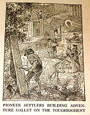 |
W Main St. (PA 136) at Youghiogheny River bridge, West Newton 40.21138°N 79.77033°W |
Roadside | Government & Politics, Government & Politics 18th Century | |
| Westmoreland County Westmoreland County, Pennsylvania -Demographics:As of the census of 2000, there were 369,993 people, 149,813 households, and 104,569 families residing in the county. The population density was 361 people per square mile . There were 161,058 housing units at an average density of 157 per square mile... |
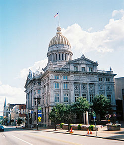 |
NE corner, Courthouse Square, Main & Otterman Sts., Greensburg 40.303°N 78.4555°W |
City | Government & Politics, Government & Politics 18th Century | |
| William Findley William Findley William Findley was an Irish-born farmer and politician from Westmoreland County, Pennsylvania. He served in both houses of the state legislature and represented Pennsylvania in the U.S. House from 1791 until 1799 and from 1803 to 1817.-Early years:William Findley was born in Ulster, Ireland and... |
Route 981 near Route 30, Latrobe °N °W |
Roadside | Government & Politics, Government & Politics 18th Century, Whiskey Rebellion | ||
| Willie Thrower (1930-2002) Willie Thrower Willie Lawrence Thrower was a American football quarterback. Born near Pittsburgh in New Kensington, Pennsylvania, Thrower was known as "Mitts" for his large hands and arm strength compared to his 5'11 frame. He was known to toss a football 60 yards... |
Valley High School, 703 Stevenson Blvd., New Kensington 40.5656°N 79.75495°W |
Roadside | African American, Football, Sports |
See also
- List of Pennsylvania state historical markers
- National Register of Historic Places listings in Westmoreland County, PennsylvaniaNational Register of Historic Places listings in Westmoreland County, PennsylvaniaThis is a list of the National Register of Historic Places listings in Westmoreland County, Pennsylvania.This is intended to be a complete list of the properties and districts on the National Register of Historic Places in Westmoreland County, Pennsylvania, United States...