

List of Registered Historic Places in Milton, Massachusetts
Encyclopedia
This is a list of properties and historic districts in Milton, Massachusetts
that are listed on the National Register of Historic Places
.
The locations of National Register properties and districts (at least for all showing latitude and longitude coordinates below) may be seen in a Google map by clicking on "Map of all coordinates".
Milton, Massachusetts
Milton is a town in Norfolk County, Massachusetts, United States and part of the Greater Boston area. The population was 27,003 at the 2010 census. Milton is the birthplace of former U.S. President George H. W. Bush and architect Buckminster Fuller. Milton also has the highest percentage of...
that are listed on the National Register of Historic Places
National Register of Historic Places
The National Register of Historic Places is the United States government's official list of districts, sites, buildings, structures, and objects deemed worthy of preservation...
.
The locations of National Register properties and districts (at least for all showing latitude and longitude coordinates below) may be seen in a Google map by clicking on "Map of all coordinates".
Current listings
| Landmark name | Image | Date listed | Location | Summary | |
|---|---|---|---|---|---|
| 1 | Belcher-Rowe House Belcher-Rowe House The Belcher-Rowe House is a historic house at 26 Governor Belcher Lane in Milton, Massachusetts.It was built in 1776 and added to the National Register of Historic Places in 1982.... |
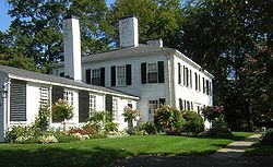 |
26 Governor Belcher Lane 42°15′34"N 71°2′58"W |
||
| 2 | G.H. Bent Company Factory | 7 Pleasant St. 42°14′42"N 71°4′10"W |
|||
| 3 | Blue Hills Headquarters Blue Hills Headquarters Blue Hills Headquarters is a historic building on Hillside Street in Milton, Massachusetts.It was built in 1904 as the headquarters building for the Blue Hills Reservation, which it still is.... |
 |
Hillside St. 42°12′56"N 71°5′35"W |
||
| 4 | Blue Hills Reservation Parkways-Metropolitan Park System of Greater Boston Blue Hills Reservation Parkways The Blue Hills Reservation Parkways is a group of historic parkways in the Blue Hills Reservation. The system was founded in 1894 and designed by Charles Eliot... |
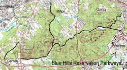 |
Parts of Blue Hill Rd., Chickatawbut Rd., Hillside St., Uniquity Rd., Wampatuck Rd., and Green St. 42°13′34"N 71°4′20"W |
Extends into Quincy and into Braintree and Canton, elsewhere in Norfolk County | |
| 5 | Blue Hills Parkway Blue Hills Parkway Blue Hills Parkway is a historic road that runs in a straight line from a crossing of the Neponset River, at the south border of Boston to the north edge of the Blue Hills Reservation in Milton, Massachusetts. It was designed by the noted landscape architect, Charles Eliot, who is perhaps best... |
 |
Blue Hills Parkway, Milton Milton, Massachusetts Milton is a town in Norfolk County, Massachusetts, United States and part of the Greater Boston area. The population was 27,003 at the 2010 census. Milton is the birthplace of former U.S. President George H. W. Bush and architect Buckminster Fuller. Milton also has the highest percentage of... 42°15′21"N 71°5′38"W |
||
| 6 | Brookwood Farm Brookwood Farm Brookwood Farm is a historic farm on Blue Hill River Road in Canton, Massachusetts. Some of its fields, but none of the buildings, are in Milton. It is owned by the Commonwealth of Massachusetts and managed by the Department of Conservation and Recreation.... |
Off Hillside Street 42°12′34"N 71°6′41"W |
Extends into Canton, elsewhere in Norfolk County | ||
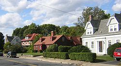
| 7 | Brush Hill Historic District Brush Hill Historic District The Brush Hill Historic District is a historic district roughly on Brush Hill Road from Robbins Street to Bradlee Road, and Dana Avenue, Brush Hill Lane, and Fairmount Avenue in Milton, Massachusetts.... |
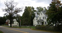 |
Roughly Brush Hill Rd., from Robbins St. to Bradlee Rd., and Dana Ave., Brush Hill Ln. and Fairmount Ave. 42°14′45"N 71°6′35"W |
||
| 8 | Comfort Station Comfort Station Comfort Station is a historic "sanitary" on Blue Hill Avenue in Milton, Massachusetts.Although finely detailed in Swiss Chalet style, this is a very simple building, built in 1904 for a single purpose which it still performs today... |
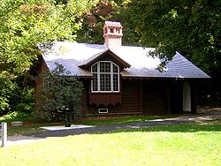 |
Blue Hill Ave. 42°13′9"N 71°7′6"W |
||
| 9 | Dorchester-Milton Lower Mills Industrial District Dorchester-Milton Lower Mills Industrial District Dorchester-Milton Lower Mills Industrial District is an historic district on both sides of the Neponset River in the Dorchester neighborhood of Boston, Massachusetts and the Town of Milton, Massachusetts... |
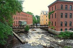 |
Both sides of the Neponset River Neponset River The Neponset River is a river in eastern Massachusetts in the United States. The headwaters of the Neponset are at the Neponset Reservoir in Foxborough, near the Gillette Stadium... ; also Adams, River, and Medway Sts., Millers Lane, and Eliot and Adams Sts. 42°16′16"N 71°4′8"W |
Extends into Boston in Suffolk County; Second set of addresses represents a boundary increase | |
| 10 | Eliot Memorial Bridge Eliot Memorial Bridge The Eliot Memorial Bridge is a footbridge which was built in 1904 in memory of Charles Eliot, landscape architect to the Metropolitan Park Commission... |
Milton 42°12′42"N 71°6′49"W |
|||
| 11 | Capt. Robert B. Forbes House | 215 Adams St. 42°15′47"N 71°3′49"W |
National Historic Landmark | ||
| 12 | Great Blue Hill Observation Tower Eliot Memorial Bridge The Eliot Memorial Bridge is a footbridge which was built in 1904 in memory of Charles Eliot, landscape architect to the Metropolitan Park Commission... |
Milton 42°12′43"N 71°6′49"W |
|||
| 13 | Great Blue Hill Weather Observatory | Milton 42°12′42"N 71°6′55"W |
A National Historic Landmark as "Blue Hill Meteorological Observatory" | ||
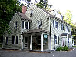
| 14 | Dr. Amos Holbrook House Dr. Amos Holbrook House Dr. Amos Holbrook House is a house in Milton, Massachusetts. It was listed on the National Register of Historic Places in 1975, and it is lies within the boundaries of the Milton Hill Historic District.... |
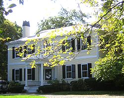 |
203 Adams St. 42°15′55"N 71°3′59"W |
||
| 15 | Gov. Thomas Hutchinson's Ha-ha | 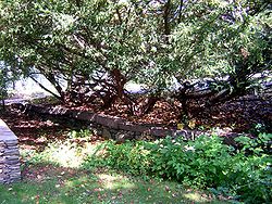 |
100 and 122 Randolph Ave. 42°15′55"N 71°4′6"W |
||
| 16 | Massachusetts Hornfels-Braintree Slate Quarry Massachusetts Hornfels-Braintree Slate Quarry The Massachusetts Hornfels-Braintree Slate Quarry is an archaeological site in Milton, Massachusetts. It consists of a series of pits and trenches used from 7,000 B.P. until the early 17th century as a source of slate and hornfels used for chipped and ground tools... |
Address Restricted | |||
| 17 | Metropolitan District Commission Stable Metropolitan District Commission Stable The Metropolitan District Commission Stable is a historic stable on Hillside Street in Milton, Massachusetts.It was built in 1908 for the Metropolitan District Commission Police and the Massachusetts State Police mounted units. In 2004, the mounted units were disbanded and the stable was emptied... |
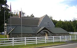 |
Hillside St. 42°12′56"N 71°5′33"W |
||
| 18 | Milton Cemetery Milton Cemetery Milton Cemetery is a historic cemetery at 211 Centre Street in Milton, Massachusetts.It was founded in 1672 and added to the National Register of Historic Places in 2004. Among those interred in the cemetery are:... |
211 Centre St. 42°15′23.6"N 71°3′55.3"W |
|||
| 19 | Milton Centre Historic District Milton Centre Historic District Milton Centre Historic District is a historic district on Canton Avenue between Readsdale Road and Thacher and Highland Streets in Milton, Massachusetts.It was built in 1907 and added to the National Register of Historic Places in 1988.... |
 |
Canton Ave. between Reedsdale Rd. and Thacher and Highland Sts. 42°15′12"N 71°4′47"W |
||
| 20 | Milton Hill Historic District Milton Hill Historic District Milton Hill Historic District is a historic district in Milton, Massachusetts. It was listed on the National Register of Historic Places in 1995.It includes the Captain Robert Bennet Forbes House, a National Historic Landmark, and the Dr... |
 |
Roughly bounded by Adams and School Sts., Randolph and Canton Aves., and Brook Rd. 42°15′52"N 71°3′59"W |
||
| 21 | Neponset Valley Parkway, Metropolitan Park System of Greater Boston Neponset Valley Parkway Neponset Valley Parkway is a historic parkway in Boston and Milton, Massachusetts, United States. The parkway was constructed from 1898 to 1929 by Charles Eliot and the Olmstead Brothers and added to the National Register of Historic Places in 2005. The parkway serves as a connector between the... |
Neponset Valley Parkway 42°14′5"N 71°7′26"W |
Extends into Boston National Register of Historic Places listings in Boston, Massachusetts This is a list of the National Register of Historic Places listings in Boston, Massachusetts.This is intended to be a complete list of the properties and districts on the National Register of Historic Places in Boston, Massachusetts, United States... in Suffolk County |
||
| 22 | Paul's Bridge Paul's Bridge Paul's Bridge is a stone overpass over the Neponset River. It is a part of the Neponset Valley Parkway, which is in itself a Historic District. It replaced an earlier Hubbard's Bridge , and a subsequent Paul's Bridge . It's span is approximately 88 feet... |
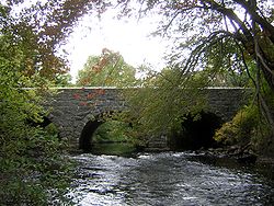 |
Neponset Valley Parkway over the Neponset River Neponset River The Neponset River is a river in eastern Massachusetts in the United States. The headwaters of the Neponset are at the Neponset Reservoir in Foxborough, near the Gillette Stadium... 42°14′4"N 71°7′21"W |
Extends into Boston National Register of Historic Places listings in Boston, Massachusetts This is a list of the National Register of Historic Places listings in Boston, Massachusetts.This is intended to be a complete list of the properties and districts on the National Register of Historic Places in Boston, Massachusetts, United States... in Suffolk County |
|
| 23 | Railway Village Historic District Railway Village Historic District Railway Village Historic District is a historic district roughly along Adams Street, from Mechanic and Church Streets, to Washington Street in Milton, Massachusetts.It was added to the National Register of Historic Places in 2000.... |
 |
Roughly along Adams St., from Mechanic and Church Sts., and Washington St. 42°15′26.9"N 71°2′14.2"W |
||
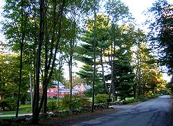
| 24 | Refreshment Pavilion Refreshment Pavilion The Refreshment Pavilion is a historic refreshment stand at Houghton's Pond in Milton, Massachusetts.It was designed by the firm of Stickney and Austin who also designed four other NRHP structures in the Blue Hills Reservation:... |
Hillside St. 42°12′31"N 71°5′52"W |
|||
| 25 | Scott's Woods Historic District Scott's Woods Historic District Scott's Woods Historic District is a historic district on Hillside Street between Randolph Avenue and the Blue Hills Reservation in Milton, Massachusetts.It was added to the National Register of Historic Places in 1992.... |
 |
Hillside St. between Randolph Ave. and MDC Blue Hills Reservation 42°13′27"N 71°4′50"W |
||
| 26 | Suffolk Resolves House Suffolk Resolves House The Suffolk Resolves House is the building where the Suffolk Resolves were signed on September 4, 1774. The Resolves were an important predecessor document to the Declaration of Independence.... |
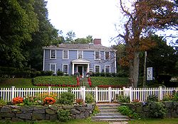 |
1370 Canton Ave. 42°14′3"N 71°6′32"W |
||
| 27 | Truman Parkway-Metropolitan Park System of Greater Boston Truman Parkway Truman Parkway is a historic parkway in Milton and Boston, Massachusetts. The parkway was built in 1931 and added to the National Register of Historic Places in 2005. It runs along the southern boundary of the Neponset River Reservation and serves as a connection between the Neponset Valley Parkway... |
Truman Parkway 42°14′53"N 71°6′59"W |
Extends into Boston National Register of Historic Places listings in Boston, Massachusetts This is a list of the National Register of Historic Places listings in Boston, Massachusetts.This is intended to be a complete list of the properties and districts on the National Register of Historic Places in Boston, Massachusetts, United States... in Suffolk County |
||
| 28 | US Post Office-Milton Main US Post Office-Milton Main US Post Office—Milton Main is a historic post office at 499 Adams Street in Milton, Massachusetts.It was built in 1936 and added to the National Register of Historic Places in 1986.-Gallery:-References:... |
499 Adams St. 42°15′30"N 71°2′34"W |