

List of Registered Historic Places in San Francisco, California
Encyclopedia
List of properties on the National Register of Historic Places
in San Francisco, California
:
National Register of Historic Places
The National Register of Historic Places is the United States government's official list of districts, sites, buildings, structures, and objects deemed worthy of preservation...
in San Francisco, California
San Francisco, California
San Francisco , officially the City and County of San Francisco, is the financial, cultural, and transportation center of the San Francisco Bay Area, a region of 7.15 million people which includes San Jose and Oakland...
:
| Site name | Image | Date listed | Address | Locality | Summary | |
|---|---|---|---|---|---|---|
| 1 | Administration Building, Treasure Island | SE Corner of Avenue of the Palms and California Ave.37.8171°N 122.3712°W | Treasure Island | NRHP #08000081 Treasure Island Museum Association | ||
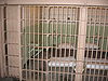
| 2 | Alcatraz Alcatraz Island Alcatraz Island is an island located in the San Francisco Bay, offshore from San Francisco, California, United States. Often referred to as "The Rock" or simply "Traz", the small island was developed with facilities for a lighthouse, a military fortification, a military prison, and a Federal... |
 |
Alcatraz Island, San Francisco Bay37.8268°N 122.4228°W | San Francisco San Francisco, California San Francisco , officially the City and County of San Francisco, is the financial, cultural, and transportation center of the San Francisco Bay Area, a region of 7.15 million people which includes San Jose and Oakland... |
NRHP #76000209. Former maximum security Federal prison, from which Frank Morris but few others escaped, now part of the Golden Gate National Recreation Area Golden Gate National Recreation Area The Golden Gate National Recreation Area is a U.S. National Recreation Area administered by the National Park Service that surrounds the San Francisco Bay area. It is one of the most visited units of the National Park system in the United States, with over 13 million visitors a year... and visited by tourist ferries. |
|
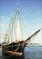
| 3 | Alma (scow schooner) Alma (1891) The Alma is an 1891 built scow schooner, which is now preserved as a National Historic Landmark at the San Francisco Maritime National Historical Park in San Francisco, California.- History of the Alma :... |
_2.jpg) |
2905 Hyde St. (Hyde St. Pier)37.8103°N 122.4227 °W | Fisherman's Wharf Fisherman's Wharf, San Francisco, California Fisherman's Wharf is a neighborhood and popular tourist attraction in San Francisco, California. It roughly encompasses the northern waterfront area of San Francisco from Ghirardelli Square or Van Ness Avenue east to Pier 35 or Kearny Street... |
NRHP #75000179. Flat-bottomed scow Scow A scow, in the original sense, is a flat-bottomed boat with a blunt bow, often used to haul bulk freight; cf. barge. The etymology of the word is from the Dutch schouwe, meaning such a boat.-Sailing scows:... schooner Schooner A schooner is a type of sailing vessel characterized by the use of fore-and-aft sails on two or more masts with the forward mast being no taller than the rear masts.... built in 1891 to haul goods on and around San Francisco Bay San Francisco Bay San Francisco Bay is a shallow, productive estuary through which water draining from approximately forty percent of California, flowing in the Sacramento and San Joaquin rivers from the Sierra Nevada mountains, enters the Pacific Ocean... and river delta areas. |
|
| 4 | Apollo (storeship) | image pending | NW corner of Sacramento and Battery Sts.37.7942°N 122.4005°W | Financial District Financial District, San Francisco, California The Financial District is a neighborhood in San Francisco, California, that serves as its main central business district. The nickname "FiDi" is occasionally employed, analogous to nearby SoMa.-Location:... |
NRHP #91000561. San Francisco History: Buried Ships |
|
| 5 | Aquatic Park Historic District Aquatic Park Historic District Aquatic Park Historic District is a building complex on the San Francisco Bay waterfront in San Francisco, California, United States. It is located within San Francisco Maritime National Historical Park and is itself a National Historic Landmark.... |
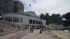 |
Bounded by Van Ness Ave., Hyde and Polk Sts.37.807°N 122.4229°W | Fisherman's Wharf Fisherman's Wharf, San Francisco, California Fisherman's Wharf is a neighborhood and popular tourist attraction in San Francisco, California. It roughly encompasses the northern waterfront area of San Francisco from Ghirardelli Square or Van Ness Avenue east to Pier 35 or Kearny Street... |
NRHP #84001183. Streamline Moderne Streamline Moderne Streamline Moderne, sometimes referred to by either name alone or as Art Moderne, was a late type of the Art Deco design style which emerged during the 1930s... building built as a public bathhouse Public bathing Public baths originated from a communal need for cleanliness. The term public may confuse some people, as some types of public baths are restricted depending on membership, gender, religious affiliation, or other reasons. As societies have changed, public baths have been replaced as private bathing... by the WPA Works Progress Administration The Works Progress Administration was the largest and most ambitious New Deal agency, employing millions of unskilled workers to carry out public works projects, including the construction of public buildings and roads, and operated large arts, drama, media, and literacy projects... in 1936. |
|
| 6 | Armour & Co. Building | 1050 Battery St.37°48′4.18"N 122°24′4.74"W | Fisherman's Wharf Fisherman's Wharf, San Francisco, California Fisherman's Wharf is a neighborhood and popular tourist attraction in San Francisco, California. It roughly encompasses the northern waterfront area of San Francisco from Ghirardelli Square or Van Ness Avenue east to Pier 35 or Kearny Street... |
NRHP #09001117; 1907 building by San Francisco architect Henry Geilfuss used as a meat packing plant and smokehouse by Armour and Company Armour and Company Armour & Company was an American slaughterhouse and meatpacking company founded in Chicago, Illinois, in 1867 by the Armour brothers, led by Philip Danforth Armour. By 1880, the company was Chicago's most important business and helped make the city and its Union Stock Yards the center of the... until 1934 |
||
| 7 | Atherton House | 1990 California St.37.79°N 122.4271°W | Lower Pacific Heights Lower Pacific Heights, San Francisco, California Lower Pacific Heights, also known as the Upper Fillmore is a neighborhood in San Francisco, California. It is located in the area between Pacific Heights, the Fillmore District, Laurel Heights, and Japantown... |
NRHP #79000527. NoeHill of San Francisco listing for Atherton House. |
||
| 8 | Audiffred Building | 1—21 Mission St.37.7934°N 122.3926°W | South Beach | NRHP #79000528 Audiffred Building San Francisco …an urban history |
||
| 9 | Baker and Hamilton | 601 Townsend St.37.7713°N 122.4019°W | South of Market South of Market, San Francisco, California South of Market is a neighborhood in San Francisco, California, United States.-Name and location:Its boundaries are Market Street to the northwest, San Francisco Bay to the northeast, Mission Creek to the southeast, and Division Street, 13th Street and U.S. Route 101 to the southwest... |
NRHP #05000001 | ||
| 10 | Balclutha Balclutha (1886) Balclutha, also known as Star of Alaska, Pacific Queen, or Sailing Ship BALCLUTHA, is a steel-hulled full rigged ship that was built in 1886. She is the only square rigged ship left in the San Francisco Bay area and is representative of several different commercial ventures, including lumber,... |
.jpg) |
Pier 41 East37.8098°N 122.4225°W | Fisherman's Wharf Fisherman's Wharf, San Francisco, California Fisherman's Wharf is a neighborhood and popular tourist attraction in San Francisco, California. It roughly encompasses the northern waterfront area of San Francisco from Ghirardelli Square or Van Ness Avenue east to Pier 35 or Kearny Street... |
NRHP #76000178; 1886 square rigged sailing ship | |
| 11 | Bank of Italy | 552 Montgomery St.37.7946°N 122.403°W | Financial District Financial District, San Francisco, California The Financial District is a neighborhood in San Francisco, California, that serves as its main central business district. The nickname "FiDi" is occasionally employed, analogous to nearby SoMa.-Location:... |
NRHP #78000754 | ||
| 12 | Beach Chalet | 1000 Great Hwy.37.7694°N 122.5103°W | Ocean Beach Ocean Beach, San Francisco, California Ocean Beach is a beach that runs along the west coast of San Francisco, California, United States, at the Pacific Ocean. It is adjacent to Golden Gate Park, the Richmond District and the Sunset District. The Great Highway runs alongside the beach, and Cliff House and the site of the former Sutro... |
NRHP #81000172 | ||
| 13 | C. A. Belden House | 2004-2010 Gough St.37.7921°N 122.4259°W | Pacific Heights Pacific Heights, San Francisco, California Pacific Heights is a neighborhood of San Francisco, California.-Location:Pacific Heights is located in one of the most scenic and park-like settings in Northern California, offering panoramic views of the Golden Gate Bridge, the San Francisco Bay, Alcatraz and the Presidio... |
NRHP #83001229 | ||
| 14 | Belt Railroad Engine House and Sandhouse | Block bounded by Lombard, Sansome, and the Embarcadero37.8046°N 122.4032°W | Fisherman's Wharf Fisherman's Wharf, San Francisco, California Fisherman's Wharf is a neighborhood and popular tourist attraction in San Francisco, California. It roughly encompasses the northern waterfront area of San Francisco from Ghirardelli Square or Van Ness Avenue east to Pier 35 or Kearny Street... |
NRHP #86000207 | ||
| 15 | Building at 1735-1737 Webster Street | 1735—1737 Webster St.37.7869°N 122.4319°W | Lower Pacific Heights Lower Pacific Heights, San Francisco, California Lower Pacific Heights, also known as the Upper Fillmore is a neighborhood in San Francisco, California. It is located in the area between Pacific Heights, the Fillmore District, Laurel Heights, and Japantown... |
NRHP #73000444 | ||
| 16 | Building at 1813-1813B Sutter Street | image pending | 1813—1813B Sutter St.37°47′11"N 122°25′50"W | Japantown | NRHP #73000443 The current address of this building is 1815 Sutter St. | |
| 17 | Building at 1840-1842 Eddy Street | 1840—1842 Eddy St.37.7808°N 122.4388°W | Western Addition Western Addition, San Francisco, California The Western Addition is a neighborhood in San Francisco, California, United States.-Location:The Western Addition is sandwiched between Van Ness Avenue, Golden Gate Park, the Upper and Lower Haight neighborhoods, and Pacific Heights.... |
NRHP #73000437 | ||
| 18 | Building at 33-35 Beideman Place | 33—35 Beideman Pl.37.7821°N 122.4385°W | Western Addition Western Addition, San Francisco, California The Western Addition is a neighborhood in San Francisco, California, United States.-Location:The Western Addition is sandwiched between Van Ness Avenue, Golden Gate Park, the Upper and Lower Haight neighborhoods, and Pacific Heights.... |
NRHP #73000435 | ||
| 19 | Building at 45-47 Beideman Place | 45—57 Beideman Pl.37.7822°N 122.4385°W | Western Addition Western Addition, San Francisco, California The Western Addition is a neighborhood in San Francisco, California, United States.-Location:The Western Addition is sandwiched between Van Ness Avenue, Golden Gate Park, the Upper and Lower Haight neighborhoods, and Pacific Heights.... |
NRHP #73000436 | ||
| 20 | Building at 465 Tenth St. | 465 Tenth St.37.7708°N 122.4101°W | South of Market South of Market, San Francisco, California South of Market is a neighborhood in San Francisco, California, United States.-Name and location:Its boundaries are Market Street to the northwest, San Francisco Bay to the northeast, Mission Creek to the southeast, and Division Street, 13th Street and U.S. Route 101 to the southwest... |
NRHP #99000581 Rothschild Building | ||
| 21 | Building at 735 Market Street | 735 Market St.37.7867°N 122.4043°W | Financial District Financial District, San Francisco, California The Financial District is a neighborhood in San Francisco, California, that serves as its main central business district. The nickname "FiDi" is occasionally employed, analogous to nearby SoMa.-Location:... |
NRHP #04000327 | ||
| 22 | Bush Street-Cottage Row Historic District | 2101-2125 Bush St., 1-6 Cottage Row, and 1940-1948 Sutter St.37.7868°N 122.4321°W | Lower Pacific Heights Lower Pacific Heights, San Francisco, California Lower Pacific Heights, also known as the Upper Fillmore is a neighborhood in San Francisco, California. It is located in the area between Pacific Heights, the Fillmore District, Laurel Heights, and Japantown... |
NRHP #82000983 | ||
| 23 | C.A. Thayer C.A. Thayer (1895) The C.A. Thayer is a schooner built in 1895 near Eureka, California. The schooner is now preserved at the San Francisco Maritime National Historical Park... |
 |
San Francisco Maritime State Historic Park37.8091°N 122.4216°W | Fisherman's Wharf Fisherman's Wharf, San Francisco, California Fisherman's Wharf is a neighborhood and popular tourist attraction in San Francisco, California. It roughly encompasses the northern waterfront area of San Francisco from Ghirardelli Square or Van Ness Avenue east to Pier 35 or Kearny Street... |
NRHP #66000229; 1895 schooner | |
| 24 | Calvary Presbyterian Church | 2501—2515 Fillmore St.37.7927°N 122.4347°W | Pacific Heights Pacific Heights, San Francisco, California Pacific Heights is a neighborhood of San Francisco, California.-Location:Pacific Heights is located in one of the most scenic and park-like settings in Northern California, offering panoramic views of the Golden Gate Bridge, the San Francisco Bay, Alcatraz and the Presidio... |
NRHP #78000755 | ||
| 25 | Camera Obscura Camera Obscura (San Francisco, California) The Camera Obscura in San Francisco is a large-scale camera obscura and is listed on the National Register of Historic Places. It is located near the Cliff House restaurant perched on the headlands on the cliffs just north of Ocean Beach on the western side of San Francisco, California... |
1096 Point Lobos Ave.37.7783°N 122.5142°W | Richmond District Richmond District, San Francisco, California The Richmond District is a neighborhood in the northwest corner of San Francisco, California.-Location:Lying directly north of Golden Gate Park, "the Richmond" is bounded roughly by Fulton Street to the south, Arguello Boulevard and Laurel Heights to the east, The Presidio National Park and Lincoln... |
NRHP #01000522 | ||
| 26 | Central Embarcadero Piers Historic District | Piers 1, 1½, 3 and 5, The Embarcadero37.7976°N 122.3956°W | Embarcadero | NRHP #02001390 | ||
| 27 | Chambord Apartments | 1298 Sacramento St.37.7925°N 122.4142°W | Nob Hill Nob Hill, San Francisco, California Nob Hill refers to a neighborhood in San Francisco, California, centered on the intersection of California and Powell streets. It is one of San Francisco's 44 hills, and one of its original "Seven Hills."-Location :... |
NRHP #84001184 | ||
| 28 | City of Paris Building | 181-199 Geary St.37.7874°N 122.4064°W | Downtown | NRHP #75000471 Neiman Marcus now occupies the site of the former City of Paris Building | ||
| 29 | Coffin-Redington Building | 301 Folsom St. and 300 Beale St.37.7885°N 122.3927°W | Rincon Hill | NRHP #01000028 | ||
| 30 | Coit Memorial Tower Coit Tower Coit Tower is a tower in the Telegraph Hill neighborhood of San Francisco, California. The tower, in the city's Pioneer Park, was built in 1933 at the request of Lillie Hitchcock Coit to beautify the city of San Francisco; Coit bequeathed one-third of her estate to the city "to be expended in an... |
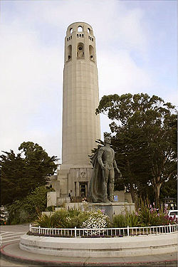 |
1 Telegraph Hill Blvd.37.8024°N 122.4058°W | Telegraph Hill Telegraph Hill, San Francisco Telegraph Hill refers to a neighborhood in San Francisco, California. It is one of San Francisco's 44 hills, and one of its original "Seven Hills."-Location:... |
NRHP #07001468 | |
| 31 | Colombo Building | 1-21 Columbus Ave.37.7956°N 122.4037°W | Financial District Financial District, San Francisco, California The Financial District is a neighborhood in San Francisco, California, that serves as its main central business district. The nickname "FiDi" is occasionally employed, analogous to nearby SoMa.-Location:... |
NRHP #07001469 | ||
| 32 | Dallam-Merritt House | 2355 Washington St.37.7918°N 122.4321°W | Pacific Heights Pacific Heights, San Francisco, California Pacific Heights is a neighborhood of San Francisco, California.-Location:Pacific Heights is located in one of the most scenic and park-like settings in Northern California, offering panoramic views of the Golden Gate Bridge, the San Francisco Bay, Alcatraz and the Presidio... |
NRHP #84001185 | ||
| 33 | Delano House | 70 Buena Vista Terr.37.7678°N 122.4384°W | Buena Vista | NRHP #82000984 | ||
| 34 | Richard P. Doolan Residence and Storefronts | 557 Ashbury St./1500-1512 Haight St.37°46′13"N 122°26′47"W | Haight-Ashbury | NRHP #09001201 | ||
| 35 | Frank G. Edwards House | 1366 Guerrero St.37.7493°N 122.4228°W | Noe Valley Noe Valley, San Francisco, California -Location:Its borders are generally considered to be 22nd Street to the north, Randall Street to the south, Dolores Street to the east, and Grand View Avenue to the west. These borders are understood to be somewhat flexible, particularly by real estate agents... |
NRHP #82000986 | ||
| 36 | Engine House No. 31 | 1088 Green St.37.7986°N 122.417°W | Russian Hill Russian Hill, San Francisco, California Russian Hill is a neighborhood of San Francisco, California, in the United States. It is one of San Francisco's 44 hills, and one of its original "Seven Hills."-Location:... |
NRHP #87002290 | ||
| 37 | Eureka | .jpg) |
San Francisco Maritime State Historic Park, 2905 Hyde St.37.8096°N 122.4216°W | Fisherman's Wharf Fisherman's Wharf, San Francisco, California Fisherman's Wharf is a neighborhood and popular tourist attraction in San Francisco, California. It roughly encompasses the northern waterfront area of San Francisco from Ghirardelli Square or Van Ness Avenue east to Pier 35 or Kearny Street... |
NRHP #73000229; 1890 steam ferryboat | |
| 38 | Fairmont Hotel The Fairmont San Francisco The Fairmont San Francisco is a luxury hotel at 950 Mason Street, atop Nob Hill in San Francisco, California. The hotel was named after mining magnate and U.S. Senator James Graham Fair , by his daughters Theresa Fair Oelrichs and Virginia Fair Vanderbilt who built the hotel in his honor. The hotel... |
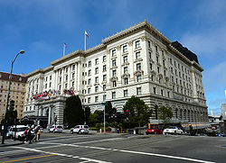 |
950 Mason St.37.7924°N 122.4106°W | Nob Hill Nob Hill, San Francisco, California Nob Hill refers to a neighborhood in San Francisco, California, centered on the intersection of California and Powell streets. It is one of San Francisco's 44 hills, and one of its original "Seven Hills."-Location :... |
NRHP #02000373 | |
| 39 | Farallon Islands Farallon Islands The Farallon Islands, or Farallones , are a group of islands and sea stacks in the Gulf of the Farallones, off the coast of San Francisco, California, USA. They lie outside the Golden Gate and south of Point Reyes, and are visible from the mainland on clear days... |
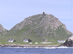 |
28 mi. W of San Francisco37.6992°N 123.0028°W | San Francisco San Francisco, California San Francisco , officially the City and County of San Francisco, is the financial, cultural, and transportation center of the San Francisco Bay Area, a region of 7.15 million people which includes San Jose and Oakland... |
NRHP #77000332 | |
| 40 | Federal Reserve Bank of San Francisco | .jpg) |
400 Sansome St.37.7943°N 122.4011°W | Financial District Financial District, San Francisco, California The Financial District is a neighborhood in San Francisco, California, that serves as its main central business district. The nickname "FiDi" is occasionally employed, analogous to nearby SoMa.-Location:... |
NRHP #89000009 | |
| 41 | Ferry Station Post Office Building | Embarcadero at Mission St.37.794°N 122.3923°W | Embarcadero | NRHP #78000756 | ||
| 42 | Feusier Octagon House Feusier Octagon House The Feusier Octagon House is an historic octagonal house located at 1067 Green Street, in the Russian Hill neighborhood of San Francisco, California. It was built between 1857 and 1858 by George Kenny, who sold it in 1870 to Louis Feusier... |
.jpg) |
1067 Green St.37.7983°N 122.4167°W | Russian Hill Russian Hill, San Francisco, California Russian Hill is a neighborhood of San Francisco, California, in the United States. It is one of San Francisco's 44 hills, and one of its original "Seven Hills."-Location:... |
NRHP #74000554 | |
| 43 | Fillmore-Pine Building | 1946 Fillmore Street37.7879°N 122.4335°W | Lower Pacific Heights Lower Pacific Heights, San Francisco, California Lower Pacific Heights, also known as the Upper Fillmore is a neighborhood in San Francisco, California. It is located in the area between Pacific Heights, the Fillmore District, Laurel Heights, and Japantown... |
NRHP #82002247 | ||
| 44 | Delia Fleishhacker Memorial Building | Zoo Rd. and Sloat Blvd.37.7335°N 122.5064°W | Parkside Parkside, San Francisco, California Parkside is a neighborhood in San Francisco. It originally began as a distinct district, but today it is generally considered to be the southern part of the Outer Sunset District.-Location:... |
NRHP #79000529 | ||
| 45 | James C. Flood Mansion James C. Flood Mansion James C. Flood Mansion, also known as Pacific-Union Club, in San Francisco, California, USA, was a townhouse for James C. Flood, a 19th century silver-baron. It was the first brownstone building built west of the Mississippi River. With The Fairmont Hotel, the only buildings on Nob Hill to... |
_4.jpg) |
California and Mason Sts.37.792°N 122.4114°W | Nob Hill Nob Hill, San Francisco, California Nob Hill refers to a neighborhood in San Francisco, California, centered on the intersection of California and Powell streets. It is one of San Francisco's 44 hills, and one of its original "Seven Hills."-Location :... |
NRHP #66000230 | |
| 46 | Folger Coffee Company Building Folger Coffee Company Building The Folgers Coffee Company Building is a mid-rise office building on the National Register of Historic Places located in downtown San Francisco.... |
101 Howard St.37.7911°N 122.3925°W | South Beach | NRHP #96000679 | ||
| 47 | Fort Mason Historic District Fort Mason Fort Mason, once known as San Francisco Port of Embarkation, US Army, in San Francisco, California, is a former United States Army post located in the northern Marina District, alongside San Francisco Bay. Fort Mason served as an Army post for more than 100 years, initially as a coastal defense... |
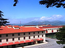 |
Portion of Fort Mason N and E of Franklin St. and McArthur Ave.37.8067°N 122.4267°W | Fort Mason Fort Mason Fort Mason, once known as San Francisco Port of Embarkation, US Army, in San Francisco, California, is a former United States Army post located in the northern Marina District, alongside San Francisco Bay. Fort Mason served as an Army post for more than 100 years, initially as a coastal defense... |
NRHP #72000109; boundary increase (listed April 23, 1979, NRHP #79000530): Bounded by Van Ness Ave., Bay and Laguna Sts. | |
| 48 | Fort Miley Military Reservation Fort Miley Military Reservation The Fort Miley Military Reservation, in San Francisco, California sits on Point Lobos , one of the outer headlands on the southern side of the Golden Gate... |
 |
Off CA 137.7827°N 122.5089°W | Richmond District Richmond District, San Francisco, California The Richmond District is a neighborhood in the northwest corner of San Francisco, California.-Location:Lying directly north of Golden Gate Park, "the Richmond" is bounded roughly by Fulton Street to the south, Arguello Boulevard and Laurel Heights to the east, The Presidio National Park and Lincoln... |
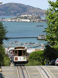
NRHP #80000371 | |
| 49 | Fort Point National Historic Site | 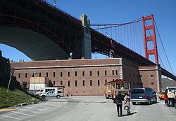 |
N tip of San Francisco Peninsula on U.S. 10137.8107°N 122.4769°W | Presidio Presidio of San Francisco The Presidio of San Francisco is a park on the northern tip of the San Francisco Peninsula in San Francisco, California, within the Golden Gate National Recreation Area... |
NRHP #70000146 | |
| 50 | Four Fifty Sutter Building | 450 Sutter St.37°47′22.50"N 122°24′28"W | Union Square Union Square, San Francisco, California Union Square is a plaza of bordered by Geary, Powell, Post and Stockton Streets in San Francisco, California. "Union Square" also refers to the central shopping, hotel, and theater district that surrounds the plaza for several blocks. The area got its name because it was once used for rallies and... |
NRHP #09001118 | ||
| 51 | Frederick Griffings's (ship) | image pending | Address Restricted37.803°N 122.4021°W | Fisherman's Wharf Fisherman's Wharf, San Francisco, California Fisherman's Wharf is a neighborhood and popular tourist attraction in San Francisco, California. It roughly encompasses the northern waterfront area of San Francisco from Ghirardelli Square or Van Ness Avenue east to Pier 35 or Kearny Street... |
NRHP #82002248 | |
| 52 | Fuller Company Glass Warehouse | 50 Green St.37.8007°N 122.4005°W | Fisherman's Wharf Fisherman's Wharf, San Francisco, California Fisherman's Wharf is a neighborhood and popular tourist attraction in San Francisco, California. It roughly encompasses the northern waterfront area of San Francisco from Ghirardelli Square or Van Ness Avenue east to Pier 35 or Kearny Street... |
NRHP #01001101 | ||
| 53 | Geary Theatre American Conservatory Theater American Conservatory Theater is a large non-profit theater company in San Francisco, California, that offers both classical and contemporary theater productions. A.C.T. was founded in 1965 in Pittsburgh, Pennsylvania in conjunction with the Pittsburgh Playhouse and Carnegie Tech by theatre and... |
.jpg) |
415 Geary St.37.787°N 122.4103°W | Downtown | NRHP #75000472 | |
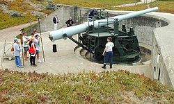
| 54 | Geneva Office Building and Power House | 2301 San Jose Ave.37°43′14.83"N 122°26′47.26"W | Excelsior | NRHP #10000111 | ||
| 55 | Daniel Gibb & Co. Warehouse | 855 Front St., and 101 Vallejo St.37.7995°N 122.4002°W | Fisherman's Wharf Fisherman's Wharf, San Francisco, California Fisherman's Wharf is a neighborhood and popular tourist attraction in San Francisco, California. It roughly encompasses the northern waterfront area of San Francisco from Ghirardelli Square or Van Ness Avenue east to Pier 35 or Kearny Street... |
NRHP #97001189 | ||
| 56 | Girls Club Girls Club (San Francisco, California) The Girls Club in San Francisco, California, also known as Mission Neighborhood Capp St. Center, was built in 1911 in the Shingle Style. It was listed on the National Register of Historic Places in 1979.... |
362 Capp St.37.761°N 122.4183°W | Mission District Mission District, San Francisco, California The Mission District, also commonly called "The Mission", is a neighborhood in San Francisco, California, USA, originally known as "the Mission lands" meaning the lands belonging to the sixth Alta California mission, Mission San Francisco de Asis... |
NRHP #79000531 | ||
| 57 | Golden Gate Park Golden Gate Park Golden Gate Park, located in San Francisco, California, is a large urban park consisting of of public grounds. Configured as a rectangle, it is similar in shape but 20% larger than Central Park in New York, to which it is often compared. It is over three miles long east to west, and about half a... |
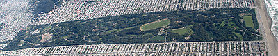 |
Bounded by Fulton St., Stanyan St., Fell St., Baker St., Oak St., Lincoln Way and The Great Highway37.7691°N 122.4837°W | Golden Gate Park Golden Gate Park Golden Gate Park, located in San Francisco, California, is a large urban park consisting of of public grounds. Configured as a rectangle, it is similar in shape but 20% larger than Central Park in New York, to which it is often compared. It is over three miles long east to west, and about half a... |
NRHP #04001137 | |
| 58 | Golden Gate Park Conservatory Conservatory of Flowers The Conservatory of Flowers is a greenhouse and botanical garden that houses a collection of rare and exotic plants in Golden Gate Park, San Francisco, California. With construction completed in 1878, it remains the oldest building in the park, and the oldest municipal wooden conservatory remaining... |
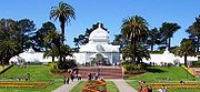 |
Mount Link, N of John F. Kennedy Dr. at E end of Golden Gate Park37.7726°N 122.4602°W | Golden Gate Park Golden Gate Park Golden Gate Park, located in San Francisco, California, is a large urban park consisting of of public grounds. Configured as a rectangle, it is similar in shape but 20% larger than Central Park in New York, to which it is often compared. It is over three miles long east to west, and about half a... |
NRHP #71000184 | |
| 59 | Goodman Building (San Francisco) | 1117 Geary Blvd.37.7855°N 122.4222°W | Western Addition Western Addition, San Francisco, California The Western Addition is a neighborhood in San Francisco, California, United States.-Location:The Western Addition is sandwiched between Van Ness Avenue, Golden Gate Park, the Upper and Lower Haight neighborhoods, and Pacific Heights.... |
NRHP #75000473 | ||
| 60 | Grabhorn Press Building | 1335 Sutter St.37.7874°N 122.4224°W | Lower Pacific Heights Lower Pacific Heights, San Francisco, California Lower Pacific Heights, also known as the Upper Fillmore is a neighborhood in San Francisco, California. It is located in the area between Pacific Heights, the Fillmore District, Laurel Heights, and Japantown... |
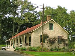
NRHP #97000349 | ||
| 61 | Haas Candy Factory | 54 Mint St.37.7826°N 122.4078°W | South of Market South of Market, San Francisco, California South of Market is a neighborhood in San Francisco, California, United States.-Name and location:Its boundaries are Market Street to the northwest, San Francisco Bay to the northeast, Mission Creek to the southeast, and Division Street, 13th Street and U.S. Route 101 to the southwest... |
NRHP #00001622 | ||
| 62 | Haas-Lilienthal House Haas-Lilienthal House The Haas-Lilienthal House at 2007 Franklin Street, San Francisco, California, USA is the city's only intact Victorian era home that is open regularly as a museum, complete with authentic furniture and artifacts.- History :... |
2007 Franklin St.37.7933°N 122.4248°W | Pacific Heights Pacific Heights, San Francisco, California Pacific Heights is a neighborhood of San Francisco, California.-Location:Pacific Heights is located in one of the most scenic and park-like settings in Northern California, offering panoramic views of the Golden Gate Bridge, the San Francisco Bay, Alcatraz and the Presidio... |
NRHP #73000438 | ||
| 63 | Hale Brothers Department Store | 901 Market St.37.7837°N 122.408°W | South of Market South of Market, San Francisco, California South of Market is a neighborhood in San Francisco, California, United States.-Name and location:Its boundaries are Market Street to the northwest, San Francisco Bay to the northeast, Mission Creek to the southeast, and Division Street, 13th Street and U.S. Route 101 to the southwest... |
NRHP #86003492; boundary increase (listed May 10, 2001, NRHP #01000490): 36 Fifth St., 423-27 and 429 Stevenson St. | ||
| 64 | Hall of Transportation, Treasure Island | SE Side of California Ave. between Avenue D and Avenue F37.8187°N 122.3679°W | Treasure Island | NRHP #08000082 | ||
| 65 | Hallidie Building Hallidie Building The Hallidie Building is an office building in the Financial District of San Francisco, California, at 130 Sutter Street, between Montgomery Street and Kearny Street... |
130 Sutter St.37.7901°N 122.403°W | Financial District Financial District, San Francisco, California The Financial District is a neighborhood in San Francisco, California, that serves as its main central business district. The nickname "FiDi" is occasionally employed, analogous to nearby SoMa.-Location:... |
NRHP #71000185 | ||
| 66 | Haslett Warehouse | 680 Beach St.37.8069°N 122.4201°W | Fisherman's Wharf Fisherman's Wharf, San Francisco, California Fisherman's Wharf is a neighborhood and popular tourist attraction in San Francisco, California. It roughly encompasses the northern waterfront area of San Francisco from Ghirardelli Square or Van Ness Avenue east to Pier 35 or Kearny Street... |
NRHP #75000172 | ||
| 67 | Herald Hotel | 308 Eddy St.37.784°N 122.4129°W | Tenderloin Tenderloin, San Francisco, California The Tenderloin is a neighborhood in downtown San Francisco, California, in the flatlands on the southern slope of Nob Hill, nestled between the Union Square shopping district to the northeast and the Civic Center office district to the southwest... |
NRHP #82000985; 1910 hotel by architect Alfred Henry Jacobs; contributing property to the Uptown Tenderloin Historic District; now a low-income public senior housing facility | ||
| 68 | Hercules (tugboat) Hercules (1907) The Hercules is a 1907 built steam tug, which is now preserved at the San Francisco Maritime National Historical Park in San Francisco, California.- History of the Hercules :... |
.jpg) |
Maritime Unit, Hyde St. Pier, National Maritime Museum37.81°N 122.4222°W | Fisherman's Wharf Fisherman's Wharf, San Francisco, California Fisherman's Wharf is a neighborhood and popular tourist attraction in San Francisco, California. It roughly encompasses the northern waterfront area of San Francisco from Ghirardelli Square or Van Ness Avenue east to Pier 35 or Kearny Street... |
NRHP #75000225; 1907 steam tug boat | |
| 69 | Hotel Californian | 403 Taylor St.37.7863°N 122.4115°W | Tenderloin Tenderloin, San Francisco, California The Tenderloin is a neighborhood in downtown San Francisco, California, in the flatlands on the southern slope of Nob Hill, nestled between the Union Square shopping district to the northeast and the Civic Center office district to the southwest... |
NRHP #98001195; 1923 hotel by architect Edward E. Young with 1929 addition by architect Alfred Henry Jacobs; contributing property to the Uptown Tenderloin Historic District; now the Serrano Hotel | ||
| 70 | House at 1239-1245 Scott Street | 1239—1245 Scott St.37.7815°N 122.4376°W | Western Addition Western Addition, San Francisco, California The Western Addition is a neighborhood in San Francisco, California, United States.-Location:The Western Addition is sandwiched between Van Ness Avenue, Golden Gate Park, the Upper and Lower Haight neighborhoods, and Pacific Heights.... |
NRHP #73000441 | ||
| 71 | House at 1249-1251 Scott Street | 1249—1251 Scott St.37.7816°N 122.4376°W | Western Addition Western Addition, San Francisco, California The Western Addition is a neighborhood in San Francisco, California, United States.-Location:The Western Addition is sandwiched between Van Ness Avenue, Golden Gate Park, the Upper and Lower Haight neighborhoods, and Pacific Heights.... |
NRHP #73000442 | ||
| 72 | House at 1254-1256 Montgomery Street | 1254—1256 Montgomery St.37.8009°N 122.4043°W | Telegraph Hill Telegraph Hill, San Francisco Telegraph Hill refers to a neighborhood in San Francisco, California. It is one of San Francisco's 44 hills, and one of its original "Seven Hills."-Location:... |
NRHP #79000532 | ||
| 73 | House at 1321 Scott Street | 1321 Scott St.37.7820°N 122.4375°W | Western Addition Western Addition, San Francisco, California The Western Addition is a neighborhood in San Francisco, California, United States.-Location:The Western Addition is sandwiched between Van Ness Avenue, Golden Gate Park, the Upper and Lower Haight neighborhoods, and Pacific Heights.... |
NRHP #73000439 | ||
| 74 | House at 1331-1335 Scott Street | 1331—1335 Scott St.37.7822°N 122.4375°W | Western Addition Western Addition, San Francisco, California The Western Addition is a neighborhood in San Francisco, California, United States.-Location:The Western Addition is sandwiched between Van Ness Avenue, Golden Gate Park, the Upper and Lower Haight neighborhoods, and Pacific Heights.... |
NRHP #73000440 | ||
| 75 | House at 584 Page Street | 584 Page St.37.7732°N 122.4303°W | Hayes Valley Hayes Valley, San Francisco, California Hayes Valley is a fashionable neighborhood in San Francisco, California, between the historical districts of Alamo Square and Civic Center. Victorian, Queen Anne, and Edwardian townhouses rub shoulders with boutiques, restaurants, and public housing complexes.... |
NRHP #85002195 Daniel Einstein House | ||
| 76 | Hunter-Dulin Building Hunter-Dulin Building The Hunter-Dulin Building is a 25-story, class A office building in the financial district of San Francisco, California. The building served as the West Coast headquarters for the National Broadcasting Company from 1927 to 1942, and is listed on the National Register of Historic Places. The... |
111 Sutter St.37.7899°N 122.4026°W | Financial District Financial District, San Francisco, California The Financial District is a neighborhood in San Francisco, California, that serves as its main central business district. The nickname "FiDi" is occasionally employed, analogous to nearby SoMa.-Location:... |
NRHP #97000348 | ||
| 77 | International Hotel I-Hotel The I-Hotel, officially known as the International Hotel, was built in 1907 after the devastating 1906 earthquake and was a low-cost residential hotel located at the corner of Kearny and Jackson Streets in the Manilatown section of San Francisco... |
848 Kearny St.37.7961°N 122.4049°W | Chinatown Chinatown, San Francisco, California San Francisco's Chinatown is the oldest Chinatown in North America and the largest Chinese community outside Asia. Since its establishment in 1848, it has been highly important and influential in the history and culture of ethnic Chinese immigrants to the United States and North America... |
NRHP #77000333 | ||
| 78 | Jackson Brewing Company | 1475—1489 Folsom St. and 319—351 11th St.37.7719°N 122.4138°W | South of Market South of Market, San Francisco, California South of Market is a neighborhood in San Francisco, California, United States.-Name and location:Its boundaries are Market Street to the northwest, San Francisco Bay to the northeast, Mission Creek to the southeast, and Division Street, 13th Street and U.S. Route 101 to the southwest... |
NRHP #93000284 | ||
| 79 | Jackson Square Historic District Jackson Square, San Francisco, California Jackson Square is a neighborhood in San Francisco, California, bounded by Pacific Ave. and Broadway east of Montgomery St., Washington St. on the south, Columbus Ave. on the west and Battery St... |
Roughly bounded by Broadway on N, Sansome St. on E, Washington St. on S, and Columbus Ave. on W37.797°N 122.4033°W | Financial District Financial District, San Francisco, California The Financial District is a neighborhood in San Francisco, California, that serves as its main central business district. The nickname "FiDi" is occasionally employed, analogous to nearby SoMa.-Location:... |
NRHP #71000186 | ||
| 80 | Jessie Street Substation | 222—226 Jessie St.37.7861°N 122.4035°W | South of Market South of Market, San Francisco, California South of Market is a neighborhood in San Francisco, California, United States.-Name and location:Its boundaries are Market Street to the northwest, San Francisco Bay to the northeast, Mission Creek to the southeast, and Division Street, 13th Street and U.S. Route 101 to the southwest... |
NRHP #74000555 The building now houses the Contemporary Jewish Museum Contemporary Jewish Museum The Contemporary Jewish Museum was founded in 1984 in San Francisco, California, with the goal of offering contemporary perspectives on Jewish culture, history, art, and ideas... (opened June 2008) |
||
| 81 | San Francisco Juvenile Court and Detention Center | 150 Otis St.37°46′15"N 122°25′14"W | South of Market | NRHP #11000182 | ||
| 82 | King Philip (ship) and Reporter (schooner) Shipwreck Site | image pending | Address Restricted | San Francisco San Francisco, California San Francisco , officially the City and County of San Francisco, is the financial, cultural, and transportation center of the San Francisco Bay Area, a region of 7.15 million people which includes San Jose and Oakland... |
NRHP #86001014 | |
| 83 | Koshland House | 3800 Washington St.37.789°N 122.4559°W | Presidio Heights | NRHP #84001186 | ||
| 84 | Dr. Martin M. Krotoszyner Medical Offices and House | 995—999 Sutter St.37.7881°N 122.4166°W | Downtown | NRHP #85001784; contributing property to the Lower Nob Hill Apartment Hotel District | ||
| 85 | Don Lee Building | 1000 Van Ness Ave.37.785°N 122.421°W | Western Addition Western Addition, San Francisco, California The Western Addition is a neighborhood in San Francisco, California, United States.-Location:The Western Addition is sandwiched between Van Ness Avenue, Golden Gate Park, the Upper and Lower Haight neighborhoods, and Pacific Heights.... |
NRHP #01001179 | ||
| 86 | Lewis Ark (houseboat) | Hyde St. Pier37.8081°N 122.4208°W | Fisherman's Wharf Fisherman's Wharf, San Francisco, California Fisherman's Wharf is a neighborhood and popular tourist attraction in San Francisco, California. It roughly encompasses the northern waterfront area of San Francisco from Ghirardelli Square or Van Ness Avenue east to Pier 35 or Kearny Street... |
NRHP #79000256 | ||
| 87 | Liberty Street Historic District | Roughly 15-188 Liberty St.37.7576°N 122.4235°W | Eureka Valley Eureka Valley, San Francisco, California Eureka Valley is a neighborhood in San Francisco, bounded by Market Street, Dolores Street, Sixteenth Street, and Noe Street.-History:In 1845 José de Jesús Noé was granted Rancho San Miguel, four thousand acres stretching from Twin Peaks into Noe and Eureka valleys. In 1854 John M... |
NRHP #83001230 | ||
| 88 | Long Syrup Refinery | 2701 Sixteenth St.37.7656°N 122.4128°W | Mission District Mission District, San Francisco, California The Mission District, also commonly called "The Mission", is a neighborhood in San Francisco, California, USA, originally known as "the Mission lands" meaning the lands belonging to the sixth Alta California mission, Mission San Francisco de Asis... |
NRHP #01001103 | ||
| 89 | Lotta Crabtree Fountain Lotta's Fountain Lotta's fountain was dedicated in 1875 at the intersection of Market Street where Geary and Kearny Streets connect in downtown San Francisco, California.... |
Market, Geary, and Kearny Sts.37.7879°N 122.4033°W | Financial District Financial District, San Francisco, California The Financial District is a neighborhood in San Francisco, California, that serves as its main central business district. The nickname "FiDi" is occasionally employed, analogous to nearby SoMa.-Location:... |
NRHP #75000475 | ||
| 90 | Lower Nob Hill Apartment Hotel District | image pending | Roughly, 590—1209 Bush, 680—1156 Sutter and 600—1099 Post Sts. and the intersecting cross streets37.7887°N 122.4136°W | Downtown/Union Square | NRHP #91000957 | |
| 91 | The Lydia | image pending | Address Restricted | San Francisco San Francisco, California San Francisco , officially the City and County of San Francisco, is the financial, cultural, and transportation center of the San Francisco Bay Area, a region of 7.15 million people which includes San Jose and Oakland... |
NRHP #81000173; Whaling bark | |
| 92 | M.V. Santa Rosa Ferryboat Santa Rosa Santa Rosa was a Steel Electric Class ferry built in Alameda, California, for Northwestern Pacific Railroad. She started out serving Southern Pacific Railways on their Golden Gate Ferries line on San Francisco Bay.... |
 |
Pier 3, San Francisco37°47′53.62"N 122°23′43.24"W | Embarcadero | Listed in the NRIS database as located Howard Terminal, Oakland. The vessel, now moored at Pier 3 in San Francisco, is owned by Hornblower Yachts and has been used as a concert venue. | |
| 93 | Market Street Theatre and Loft District | image pending | 982—1112 Market, 973—1105 Market, 1 Jones, and 1—35 Taylor Sts.37.782°N 122.4108°W | Tenderloin Tenderloin, San Francisco, California The Tenderloin is a neighborhood in downtown San Francisco, California, in the flatlands on the southern slope of Nob Hill, nestled between the Union Square shopping district to the northeast and the Civic Center office district to the southwest... |
NRHP #86000729 | |
| 94 | Matson Building and Annex | 215 Market St.37.7927°N 122.3966°W | Financial District Financial District, San Francisco, California The Financial District is a neighborhood in San Francisco, California, that serves as its main central business district. The nickname "FiDi" is occasionally employed, analogous to nearby SoMa.-Location:... |
NRHP #95001384 | ||
| 95 | McElroy Octagon House McElroy Octagon House The McElroy Octagon House, also known as the Colonial Dames Octagon House, is an historic octagonal house now located at 2645 Gough Street at Union Street in the Cow Hollow section of San Francisco, California. William C. McElroy built it in 1861 across the street from its present location... |
_2.jpg) |
2645 Gough St.37.7978°N 122.4274°W | Cow Hollow | NRHP #72000250 | |
| 96 | John McMullen House | 827 Guerrero St.37.7579°N 122.4232°W | Eureka Valley Eureka Valley, San Francisco, California Eureka Valley is a neighborhood in San Francisco, bounded by Market Street, Dolores Street, Sixteenth Street, and Noe Street.-History:In 1845 José de Jesús Noé was granted Rancho San Miguel, four thousand acres stretching from Twin Peaks into Noe and Eureka valleys. In 1854 John M... |
NRHP #83001231 | ||
| 97 | Mills Building and Tower | 220 Montgomery St. and 220 Bush St.37.7912°N 122.4018°W | Financial District Financial District, San Francisco, California The Financial District is a neighborhood in San Francisco, California, that serves as its main central business district. The nickname "FiDi" is occasionally employed, analogous to nearby SoMa.-Location:... |
NRHP #77000334 | ||
| 98 | Mish House | 1153 Oak St.37.7729°N 122.4383°W | Haight-Ashbury | NRHP #79000534 | ||
| 99 | Mission Dolores | 320 Dolores St.37.7642°N 122.4266°W | Mission District Mission District, San Francisco, California The Mission District, also commonly called "The Mission", is a neighborhood in San Francisco, California, USA, originally known as "the Mission lands" meaning the lands belonging to the sixth Alta California mission, Mission San Francisco de Asis... |
NRHP #72000251 | ||
| 100 | Moss Flats Building | 1626 Great Hwy.37.7561°N 122.5087°W | Sunset Sunset District, San Francisco, California The Sunset District is a large neighborhood in the west-central part of San Francisco, California, United States.-Location:The Sunset District is the largest district within the city of San Francisco. Golden Gate Park forms the neighborhood's northern border, and the Pacific Ocean forms its... |
NRHP #83001232 | ||
| 101 | Myrtle Street Flats | 234—248 Myrtle St.37.7852°N 122.4222°W | Western Addition Western Addition, San Francisco, California The Western Addition is a neighborhood in San Francisco, California, United States.-Location:The Western Addition is sandwiched between Van Ness Avenue, Golden Gate Park, the Upper and Lower Haight neighborhoods, and Pacific Heights.... |
NRHP #76000520 | ||
| 102 | National Carbon Company Building | 599 8th St.37.7715°N 122.4054°W | South of Market South of Market, San Francisco, California South of Market is a neighborhood in San Francisco, California, United States.-Name and location:Its boundaries are Market Street to the northwest, San Francisco Bay to the northeast, Mission Creek to the southeast, and Division Street, 13th Street and U.S. Route 101 to the southwest... |
NRHP #83001233 | ||
| 103 | New Mission Theater | 2550 Mission St.37.7563°N 122.419°W | Mission District Mission District, San Francisco, California The Mission District, also commonly called "The Mission", is a neighborhood in San Francisco, California, USA, originally known as "the Mission lands" meaning the lands belonging to the sixth Alta California mission, Mission San Francisco de Asis... |
NRHP #01001206 San Francisco's New Mission Theater Chronology at The Friends of 1800 website. | ||
| 104 | Niantic Niantic (whaling vessel) Niantic was a whaleship that brought fortune-seekers to Yerba Buena later renamed San Francisco during the California Gold Rush of 1849. Run aground and converted into a storeship and hotel, she was a prominent landmark in the booming city for several years. The site of Niantic beside the... (storeship) |
NW corner of Clay and Sansome Sts.37.7949°N 122.4016°W | Financial District Financial District, San Francisco, California The Financial District is a neighborhood in San Francisco, California, that serves as its main central business district. The nickname "FiDi" is occasionally employed, analogous to nearby SoMa.-Location:... |
NRHP #91000563 | ||
| 105 | Ohlandt Newlyweds House | image pending | 1260 Potrero Ave.37.7522°N 122.4065°W | Mission District Mission District, San Francisco, California The Mission District, also commonly called "The Mission", is a neighborhood in San Francisco, California, USA, originally known as "the Mission lands" meaning the lands belonging to the sixth Alta California mission, Mission San Francisco de Asis... |
NRHP #94000995 | |
| 106 | Old Ohio Street Houses | 17—55 Osgood Pl.37.798°N 122.4031°W | Financial District Financial District, San Francisco, California The Financial District is a neighborhood in San Francisco, California, that serves as its main central business district. The nickname "FiDi" is occasionally employed, analogous to nearby SoMa.-Location:... |
NRHP #79000535 | ||
| 107 | Old U.S. Mint San Francisco Mint The San Francisco Mint is a branch of the United States Mint, and was opened in 1854 to serve the gold mines of the California Gold Rush. It quickly outgrew its first building and moved into a new one in 1874. This building, the Old United States Mint, also known affectionately as The Granite Lady,... |
_3.jpg) |
5th and Mission Sts.37.7829°N 122.4071°W | South of Market South of Market, San Francisco, California South of Market is a neighborhood in San Francisco, California, United States.-Name and location:Its boundaries are Market Street to the northwest, San Francisco Bay to the northeast, Mission Creek to the southeast, and Division Street, 13th Street and U.S. Route 101 to the southwest... |
NRHP #66000231 | |
| 108 | One Lombard Street | 1 Lombard St.37°48′14.5"N 122°24′10.08"W | Fisherman's Wharf Fisherman's Wharf, San Francisco, California Fisherman's Wharf is a neighborhood and popular tourist attraction in San Francisco, California. It roughly encompasses the northern waterfront area of San Francisco from Ghirardelli Square or Van Ness Avenue east to Pier 35 or Kearny Street... |
NRHP #09001300 | ||
| 109 | Otis Elevator Company Building | 1 Beach St.37.8079°N 122.4095°W | Fisherman's Wharf Fisherman's Wharf, San Francisco, California Fisherman's Wharf is a neighborhood and popular tourist attraction in San Francisco, California. It roughly encompasses the northern waterfront area of San Francisco from Ghirardelli Square or Van Ness Avenue east to Pier 35 or Kearny Street... |
NRHP #99001265 | ||
| 110 | Pacific Gas and Electric Company General Office Building and Annex | 245 Market St.37.7925°N 122.3969°W | Financial District Financial District, San Francisco, California The Financial District is a neighborhood in San Francisco, California, that serves as its main central business district. The nickname "FiDi" is occasionally employed, analogous to nearby SoMa.-Location:... |
NRHP #95001385 | ||
| 111 | Pacific Gas and Electric Company Substation J | 565 Commercial and 568 Sacramento Sts.37.794°N 122.4021°W | Financial District Financial District, San Francisco, California The Financial District is a neighborhood in San Francisco, California, that serves as its main central business district. The nickname "FiDi" is occasionally employed, analogous to nearby SoMa.-Location:... |
NRHP #86003514 | ||
| 112 | Paige Motor Car Co. Building | 1699 Van Ness Ave.37.7912°N 122.4227°W | Civic Center Civic Center, San Francisco, California The Civic Center in San Francisco, California, is an area of a few blocks north of the intersection of Market Street and Van Ness Avenue that contains many of the city's largest government and cultural institutions. It has two large plazas and a number of buildings in classical architectural style... |
NRHP #83001234 | ||
| 113 | Palace of Fine and Decorative Arts, Treasure Island | SE Side of California Ave. between Avenue F and Avenue I37.8196°N 122.366°W | Treasure Island | NRHP #08000083. "Regilded Gate", Time Time (magazine) Time is an American news magazine. A European edition is published from London. Time Europe covers the Middle East, Africa and, since 2003, Latin America. An Asian edition is based in Hong Kong... , 1939-09-04 |
||
| 114 | Palace of Fine Arts Palace of Fine Arts The Palace of Fine Arts in the Marina District of San Francisco, California, is a monumental structure originally constructed for the 1915 Panama-Pacific Exposition in order to exhibit works of art presented there. One of only a few surviving structures from the Exposition, it is the only one still... |
3301 Lyon St.37.8029°N 122.4484°W | Marina District Marina District, San Francisco, California The Marina District is a neighborhood located in San Francisco, California. The neighborhood sits on the site of the 1915 Panama-Pacific International Exposition, staged after the 1906 San Francisco earthquake to celebrate the reemergence of the city... |
NRHP #04000659 | ||
| 115 | Park View Hotel | 750 Stanyan St.37.7682°N 122.4532°W | Haight-Ashbury | NRHP #83001235 | ||
| 116 | Theodore F. Payne House | 1409 Sutter St.37.7871°N 122.4239°W | Lower Pacific Heights Lower Pacific Heights, San Francisco, California Lower Pacific Heights, also known as the Upper Fillmore is a neighborhood in San Francisco, California. It is located in the area between Pacific Heights, the Fillmore District, Laurel Heights, and Japantown... |
NRHP #80000847 | ||
| 117 | Abner Phelps House | 1111 Oak St.37.7728°N 122.4381°W | Haight-Ashbury | NRHP #71000187 | ||
| 118 | Pier One | Pier One, The Embarcadero (at Washington St.)37.797°N 122.3948°W | Embarcadero | NRHP #98001551 | ||
| 119 | Pioneer Trunk Factory-C. A. Malm & Co. | 2185—2199 Folsom and 3180 18th Sts.37.7622°N 122.4148°W | Mission District Mission District, San Francisco, California The Mission District, also commonly called "The Mission", is a neighborhood in San Francisco, California, USA, originally known as "the Mission lands" meaning the lands belonging to the sixth Alta California mission, Mission San Francisco de Asis... |
NRHP #86003727 | ||
| 120 | Pioneer Woolen Mills and D. Ghirardelli Company Ghirardelli Square Ghirardelli Square is a landmark with shops and restaurants in the Fisherman's Wharf area of San Francisco, California, USA. A portion of the area is listed on the National Register of Historic Places as Pioneer Woolen Mills and D. Ghirardelli Company.... |
900 N. Point St.37.8055°N 122.4235°W | Fisherman's Wharf Fisherman's Wharf, San Francisco, California Fisherman's Wharf is a neighborhood and popular tourist attraction in San Francisco, California. It roughly encompasses the northern waterfront area of San Francisco from Ghirardelli Square or Van Ness Avenue east to Pier 35 or Kearny Street... |
NRHP #82002249 | ||
| 121 | Point Lobos Archaeological Sites | Address Restricted37.7801°N 122.5138°W | Richmond District Richmond District, San Francisco, California The Richmond District is a neighborhood in the northwest corner of San Francisco, California.-Location:Lying directly north of Golden Gate Park, "the Richmond" is bounded roughly by Fulton Street to the south, Arguello Boulevard and Laurel Heights to the east, The Presidio National Park and Lincoln... |
NRHP #76000176 | ||
| 122 | Port of San Francisco Embarcadero Historic District The Embarcadero (San Francisco) The Embarcadero is the eastern waterfront and roadway of the Port of San Francisco, San Francisco, California, along San Francisco Bay, constructed atop an engineered seawall on reclaimed land, and derives its name from the Spanish verb embarcar, meaning "to embark"... |
image pending | From Pier 45 to Pier 48, The Embarcadero37.7969°N 122.395°W | Embarcadero | NRHP #06000372 | |
| 123 | Presidio Presidio of San Francisco The Presidio of San Francisco is a park on the northern tip of the San Francisco Peninsula in San Francisco, California, within the Golden Gate National Recreation Area... |
 |
Northern tip of San Francisco Peninsula on U.S. 10137.7964°N 122.4653°W | Presidio Presidio of San Francisco The Presidio of San Francisco is a park on the northern tip of the San Francisco Peninsula in San Francisco, California, within the Golden Gate National Recreation Area... |
NRHP #66000232 | |
| 124 | Pumping Station No. 2 San Francisco Fire Department Auxiliary Water Supply System | N end of Van Ness Ave37.808°N 122.4269°W | Fisherman's Wharf Fisherman's Wharf, San Francisco, California Fisherman's Wharf is a neighborhood and popular tourist attraction in San Francisco, California. It roughly encompasses the northern waterfront area of San Francisco from Ghirardelli Square or Van Ness Avenue east to Pier 35 or Kearny Street... |
NRHP #76000177 | ||
| 125 | Quarters 1, Yerba Buena Island Naval Training Station Yerba Buena Island Yerba Buena Island sits in the San Francisco Bay between San Francisco and Oakland, California. The Yerba Buena Tunnel runs through its center and connects the western and eastern spans of the San Francisco-Oakland Bay Bridge. It has had several other names over the decades: Sea Bird Island, Wood... |
1 Whiting Way, Yerba Buena Island37.8127°N 122.3636°W | Yerba Buena Island Yerba Buena Island Yerba Buena Island sits in the San Francisco Bay between San Francisco and Oakland, California. The Yerba Buena Tunnel runs through its center and connects the western and eastern spans of the San Francisco-Oakland Bay Bridge. It has had several other names over the decades: Sea Bird Island, Wood... |
NRHP #91001380 | ||
| 126 | Quarters 10 and Building 267, Yerba Buena Island Yerba Buena Island Yerba Buena Island sits in the San Francisco Bay between San Francisco and Oakland, California. The Yerba Buena Tunnel runs through its center and connects the western and eastern spans of the San Francisco-Oakland Bay Bridge. It has had several other names over the decades: Sea Bird Island, Wood... |
Jct. Northgate & Macalla Rds., North Shore of Yerba Buena Island37.8119°N 122.3641°W | Yerba Buena Island Yerba Buena Island Yerba Buena Island sits in the San Francisco Bay between San Francisco and Oakland, California. The Yerba Buena Tunnel runs through its center and connects the western and eastern spans of the San Francisco-Oakland Bay Bridge. It has had several other names over the decades: Sea Bird Island, Wood... |
NRHP #08000084 | ||
| 127 | Rialto Building | 116 New Montgomery St.37°47′14"N 122°24′1"W | South of Market South of Market, San Francisco, California South of Market is a neighborhood in San Francisco, California, United States.-Name and location:Its boundaries are Market Street to the northwest, San Francisco Bay to the northeast, Mission Creek to the southeast, and Division Street, 13th Street and U.S. Route 101 to the southwest... |
NRHP #10001108 | ||
| 128 | Rincon Annex | 101—199 Mission St.37.7928°N 122.3934°W | South Beach | NRHP #79000537 | ||
| 129 | Roos House | 3500 Jackson St.37°47′25.54"N 122°27′9.91"W | Presidio Heights | NRHP #09000805 | ||
| 130 | Russian Hill-Macondray Lane District | image pending | Roughly 900—982 Green, 1918—1960 Jones, 15—84 Macondray & 1801—1809 Taylor37.7992°N 122.4148°W | Russian Hill Russian Hill, San Francisco, California Russian Hill is a neighborhood of San Francisco, California, in the United States. It is one of San Francisco's 44 hills, and one of its original "Seven Hills."-Location:... |
NRHP #87002286 | |
| 131 | Russian Hill-Paris Block Architectural District | image pending | Roughly 1017—1067 Green St.37.7984°N 122.4164°W | Russian Hill Russian Hill, San Francisco, California Russian Hill is a neighborhood of San Francisco, California, in the United States. It is one of San Francisco's 44 hills, and one of its original "Seven Hills."-Location:... |
NRHP #87002288 | |
| 132 | Russian Hill-Vallejo Street Crest District | image pending | Roughly 1020-1032 Broadway, 1-49 Florence, 1728-1742 Jones, 1-7 Russian Hill Pl., 1629-1715 Taylor, & 1000-1085 Vallejo37.7977°N 122.4145°W | Russian Hill Russian Hill, San Francisco, California Russian Hill is a neighborhood of San Francisco, California, in the United States. It is one of San Francisco's 44 hills, and one of its original "Seven Hills."-Location:... |
NRHP #87002289 | |
| 133 | San Francisco Cable Cars San Francisco cable car system The San Francisco cable car system is the world's last permanently operational manually operated cable car system, in the US sense of a tramway whose cars are pulled along by cables embedded in the street. It is an icon of San Francisco, California... |
 |
1390 Washington St.37.7938°N 122.4162°W | San Francisco San Francisco, California San Francisco , officially the City and County of San Francisco, is the financial, cultural, and transportation center of the San Francisco Bay Area, a region of 7.15 million people which includes San Jose and Oakland... |
NRHP #66000233 | |
| 134 | San Francisco Civic Center Historic District Civic Center, San Francisco, California The Civic Center in San Francisco, California, is an area of a few blocks north of the intersection of Market Street and Van Ness Avenue that contains many of the city's largest government and cultural institutions. It has two large plazas and a number of buildings in classical architectural style... |
 |
Roughly bounded by Golden Gate Ave., 7th, Franklin, Hayes, and Market Sts.37.7795°N 122.4176°W | Civic Center Civic Center, San Francisco, California The Civic Center in San Francisco, California, is an area of a few blocks north of the intersection of Market Street and Van Ness Avenue that contains many of the city's largest government and cultural institutions. It has two large plazas and a number of buildings in classical architectural style... |
NRHP #78000757 | |
| 135 | San Francisco Fire Department Engine Co. Number 2 | 460 Bush St.37.7908°N 122.4051°W | Downtown | NRHP #02000371 | ||
| 136 | San Francisco Maritime National Historic Park |  |
Fort Mason, Bld. 20137.8056°N 122.428°W | Fort Mason Fort Mason Fort Mason, once known as San Francisco Port of Embarkation, US Army, in San Francisco, California, is a former United States Army post located in the northern Marina District, alongside San Francisco Bay. Fort Mason served as an Army post for more than 100 years, initially as a coastal defense... |
NRHP #01000281 | |
| 137 | San Francisco National Guard Armory and Arsenal | .jpg) |
1800 Mission St.37.7681°N 122.4202°W | Mission District Mission District, San Francisco, California The Mission District, also commonly called "The Mission", is a neighborhood in San Francisco, California, USA, originally known as "the Mission lands" meaning the lands belonging to the sixth Alta California mission, Mission San Francisco de Asis... |
NRHP #78000758 | |
| 138 | San Francisco – Oakland Bay Bridge | I-8037.8005°N 122.3754°W | San Francisco San Francisco, California San Francisco , officially the City and County of San Francisco, is the financial, cultural, and transportation center of the San Francisco Bay Area, a region of 7.15 million people which includes San Jose and Oakland... |
NRHP #00000525 | ||
| 139 | San Francisco Port of Embarkation, US Army | Ft. Mason37.8073°N 122.4312°W | Fort Mason Fort Mason Fort Mason, once known as San Francisco Port of Embarkation, US Army, in San Francisco, California, is a former United States Army post located in the northern Marina District, alongside San Francisco Bay. Fort Mason served as an Army post for more than 100 years, initially as a coastal defense... |
NRHP #85002433 | ||
| 140 | San Francisco Public Library North Beach Branch | image pending | 2000 Mason St.37°48′7"N 122°24′46"W | North Beach | NRHP #11000501 | |
| 141 | San Francisco State Teacher's College San Francisco State University San Francisco State University is a public university located in San Francisco, California. As part of the 23-campus California State University system, the university offers over 100 areas of study from nine academic colleges... |
image pending | 55 Laguna St.37.7713°N 122.4255°W | Hayes Valley Hayes Valley, San Francisco, California Hayes Valley is a fashionable neighborhood in San Francisco, California, between the historical districts of Alamo Square and Civic Center. Victorian, Queen Anne, and Edwardian townhouses rub shoulders with boutiques, restaurants, and public housing complexes.... |
NRHP #07001391 | |
| 142 | Schoenstein and Company Pipe Organ Factory | 3101 20th St.37.759°N 122.4117°W | Mission District Mission District, San Francisco, California The Mission District, also commonly called "The Mission", is a neighborhood in San Francisco, California, USA, originally known as "the Mission lands" meaning the lands belonging to the sixth Alta California mission, Mission San Francisco de Asis... |
NRHP #78000759 | ||
| 143 | Irving Murray Scott School | 1060 Tennessee St.37.7586°N 122.3895°W | Potrero Hill Potrero Hill, San Francisco, California Potrero Hill is a hilly neighborhood in San Francisco, California.-Location:Potrero Hill is located on the eastern side of the city, east of the Mission District and south of SOMA and the newly designated district . It is roughly bordered by 16th Street to the north, Potrero Avenue and U.S... |
NRHP #85000714 | ||
| 144 | Second and Howard Streets District | image pending | 121-198 2nd, 579-612 Howard, 116 Natoma, 111-163 New Montgomery37.7871°N 122.3993°W | South of Market South of Market, San Francisco, California South of Market is a neighborhood in San Francisco, California, United States.-Name and location:Its boundaries are Market Street to the northwest, San Francisco Bay to the northeast, Mission Creek to the southeast, and Division Street, 13th Street and U.S. Route 101 to the southwest... |
NRHP #99000894 | |
| 145 | Senior Officers Quarters Historic District, Yerba Buena Island Yerba Buena Island Yerba Buena Island sits in the San Francisco Bay between San Francisco and Oakland, California. The Yerba Buena Tunnel runs through its center and connects the western and eastern spans of the San Francisco-Oakland Bay Bridge. It has had several other names over the decades: Sea Bird Island, Wood... |
image pending | Whiting Way at Northgate Rd., North shore of Yerba Buena Island37.813°N 122.3642°W | Yerba Buena Island Yerba Buena Island Yerba Buena Island sits in the San Francisco Bay between San Francisco and Oakland, California. The Yerba Buena Tunnel runs through its center and connects the western and eastern spans of the San Francisco-Oakland Bay Bridge. It has had several other names over the decades: Sea Bird Island, Wood... |
NRHP #08000085. Includes Quarters 1-7 and associated garages (Buildings 83, 205, and 230). | |
| 146 | Six-Inch Rifled Gun No. 9 Battery Chamberlin Battery Chamberlin is an artillery battery in the Presidio of San Francisco, San Francisco, California, United States. The battery is named in honor of Captain Lowell A... |
 |
Baker Beach37.7936°N 122.4829°W | Presidio Presidio of San Francisco The Presidio of San Francisco is a park on the northern tip of the San Francisco Peninsula in San Francisco, California, within the Golden Gate National Recreation Area... |
NRHP #79000255 | |
| 147 | South San Francisco Opera House | 4701-4705 Third St. and 1601 Newcomb Ave.37°44′6"N 122°23′25"W | Bayview-Hunters Point | NRHP #11000117 | ||
| 148 | Southern Pacific Company Hospital Historic District | 1400 Fell St.37°46′25.19"N 122°26′27.5"W | North Panhandle | NRHP #89000319 | ||
| 149 | John Spencer House | 1080 Haight St.37.771°N 122.4402°W | Haight-Ashbury | NRHP #05000273 | ||
| 150 | SS Jeremiah O'Brien National Historic Landmark SS Jeremiah O'Brien -See also:*Liberty ship*Victory ship - other surviving Liberty ship*Nash - last surviving Army ship at D-Day... |
.jpg) |
Pier 3, Fort Mason Center37.811°N 122.418°W | Fisherman's Wharf Fisherman's Wharf, San Francisco, California Fisherman's Wharf is a neighborhood and popular tourist attraction in San Francisco, California. It roughly encompasses the northern waterfront area of San Francisco from Ghirardelli Square or Van Ness Avenue east to Pier 35 or Kearny Street... |
NRHP #78003405 | |
| 151 | SS Rio De Janeiro Shipwreck SS City of Rio De Janeiro The SS City of Rio de Janeiro was an iron hulled steam powered passenger ship, launched in 1878, which sailed between San Francisco and various Asian Pacific ports. On 21 February 1901, the vessel sank after striking a submerged reef at the entry to San Francisco Bay while inward bound from Hong... |
image pending | Address Restricted | San Francisco San Francisco, California San Francisco , officially the City and County of San Francisco, is the financial, cultural, and transportation center of the San Francisco Bay Area, a region of 7.15 million people which includes San Jose and Oakland... |
NRHP #88002394 | |
| 152 | Stadtmuller House | 819 Eddy St.37.7826°N 122.4217°W | Western Addition Western Addition, San Francisco, California The Western Addition is a neighborhood in San Francisco, California, United States.-Location:The Western Addition is sandwiched between Van Ness Avenue, Golden Gate Park, the Upper and Lower Haight neighborhoods, and Pacific Heights.... |
NRHP #76000523 | ||
| 153 | St. John's Presbyterian Church | 25 Lake St. and 201 Arguello Blvd.37.7868°N 122.4595°W | Presidio Heights | NRHP #95001555 | ||
| 154 | St. Joseph's Church and Complex | 1401—1415 Howard St.37.7737°N 122.4145°W | South of Market South of Market, San Francisco, California South of Market is a neighborhood in San Francisco, California, United States.-Name and location:Its boundaries are Market Street to the northwest, San Francisco Bay to the northeast, Mission Creek to the southeast, and Division Street, 13th Street and U.S. Route 101 to the southwest... |
NRHP #82002250 | ||
| 155 | St. Joseph's Hospital | 355 Buena Vista Ave. East37.7675°N 122.44°W | Buena Vista | NRHP #85001016 | ||
| 156 | St. Paulus Lutheran Church | image pending | 999 Eddy St.37.7824°N 122.4239°W | Western Addition Western Addition, San Francisco, California The Western Addition is a neighborhood in San Francisco, California, United States.-Location:The Western Addition is sandwiched between Van Ness Avenue, Golden Gate Park, the Upper and Lower Haight neighborhoods, and Pacific Heights.... |
NRHP #82002251 Burned to the ground November 1995. | |
| 157 | Swedenborgian Church Swedenborgian Church (San Francisco, California) Swedenborgian Church is a Swedenborgian church significant for its architecture in the Pacific Heights neighborhood of San Francisco, California. It is regarded as one of California's earliest pure Arts and Crafts buildings. The first pastor of the church the Reverend Joseph Worcester bought the... |
.jpg) |
3200 Washington St.37.7904°N 122.4462°W | Pacific Heights Pacific Heights, San Francisco, California Pacific Heights is a neighborhood of San Francisco, California.-Location:Pacific Heights is located in one of the most scenic and park-like settings in Northern California, offering panoramic views of the Golden Gate Bridge, the San Francisco Bay, Alcatraz and the Presidio... |
NRHP #04001154 | |
| 158 | Temple Sherith Israel Congregation Sherith Israel (San Francisco, California) Congregation Sherith Israel is one of the oldest synagogues in the United States. It was established during California’s Gold Rush period and reflects the ambitions of early Jewish settlers to San Francisco. Today it is a congregation widely known for its innovative approach to worship and... |
2266 California St.37°47′22.08"N 122°25′54.52"W | Pacific Heights Pacific Heights, San Francisco, California Pacific Heights is a neighborhood of San Francisco, California.-Location:Pacific Heights is located in one of the most scenic and park-like settings in Northern California, offering panoramic views of the Golden Gate Bridge, the San Francisco Bay, Alcatraz and the Presidio... |
NRHP #10000114 | ||
| 159 | The Real Estate Associates (TREA) Houses | 2503, 2524, 2530 and 2536 Clay Sts.37.7905°N 122.4348°W | Pacific Heights Pacific Heights, San Francisco, California Pacific Heights is a neighborhood of San Francisco, California.-Location:Pacific Heights is located in one of the most scenic and park-like settings in Northern California, offering panoramic views of the Golden Gate Bridge, the San Francisco Bay, Alcatraz and the Presidio... |
NRHP #85000705 | ||
| 160 | Tobin House | 1969 California St.37°47′22.24"N 122°25′35.93"W | Lower Pacific Heights Lower Pacific Heights, San Francisco, California Lower Pacific Heights, also known as the Upper Fillmore is a neighborhood in San Francisco, California. It is located in the area between Pacific Heights, the Fillmore District, Laurel Heights, and Japantown... |
NRHP #09000806 | ||
| 161 | Torpedo Storehouse-Torpedo (Mine) Assembly Building & Long Range Accuracy Storage Building | image pending | East Point; North Shore of Yerba Buena Island37.8147°N 122.3593°W | Yerba Buena Island Yerba Buena Island Yerba Buena Island sits in the San Francisco Bay between San Francisco and Oakland, California. The Yerba Buena Tunnel runs through its center and connects the western and eastern spans of the San Francisco-Oakland Bay Bridge. It has had several other names over the decades: Sea Bird Island, Wood... |
NRHP #08000086 | |
| 162 | Trinity Presbyterian Church | 3261 23rd St.37.7538°N 122.4176°W | Mission District Mission District, San Francisco, California The Mission District, also commonly called "The Mission", is a neighborhood in San Francisco, California, USA, originally known as "the Mission lands" meaning the lands belonging to the sixth Alta California mission, Mission San Francisco de Asis... |
NRHP #82002252 | ||
| 163 | Tubbs Cordage Company Office Building Tubbs Cordage Company Office Building The Tubbs Cordage Company Office Building is a small frame structure located in San Francisco Maritime National Historical Park. The 1890 structure was originally located at the Tubbs Cordage factory, at 611-613 Front Street, San Francisco... |
.jpg) |
Hyde St. Pier37.8088°N 122.421°W | Fisherman's Wharf Fisherman's Wharf, San Francisco, California Fisherman's Wharf is a neighborhood and popular tourist attraction in San Francisco, California. It roughly encompasses the northern waterfront area of San Francisco from Ghirardelli Square or Van Ness Avenue east to Pier 35 or Kearny Street... |
NRHP #79000254 | |
| 164 | Union Ferry Depot | Embarcadero at Market St.37.7954°N 122.3936°W | Embarcadero | NRHP #78000760 | ||
| 165 | Uptown Tenderloin Historic District | image pending | All or part of 33 blocks roughly bounded by Market, McAllister, Golden Gate, Larkin, Geary, Taylor, Ellis Sts.37°47′1.68"N 122°24′51.12"W | Tenderloin Tenderloin, San Francisco, California The Tenderloin is a neighborhood in downtown San Francisco, California, in the flatlands on the southern slope of Nob Hill, nestled between the Union Square shopping district to the northeast and the Civic Center office district to the southwest... |
NRHP #08001407 | |
| 166 | U.S. Customhouse | 555 Battery St.37.7963°N 122.4008°W | Financial District Financial District, San Francisco, California The Financial District is a neighborhood in San Francisco, California, that serves as its main central business district. The nickname "FiDi" is occasionally employed, analogous to nearby SoMa.-Location:... |
NRHP #75000476 | ||
| 167 | U.S. Mint San Francisco Mint The San Francisco Mint is a branch of the United States Mint, and was opened in 1854 to serve the gold mines of the California Gold Rush. It quickly outgrew its first building and moved into a new one in 1874. This building, the Old United States Mint, also known affectionately as The Granite Lady,... |
155 Hermann St.37.7703°N 122.4274°W | Hayes Valley Hayes Valley, San Francisco, California Hayes Valley is a fashionable neighborhood in San Francisco, California, between the historical districts of Alamo Square and Civic Center. Victorian, Queen Anne, and Edwardian townhouses rub shoulders with boutiques, restaurants, and public housing complexes.... |
NRHP #88000026 | ||
| 168 | U.S. Post Office and Courthouse | NE corner of 7th and Mission Sts.37.7795°N 122.411°W | South of Market South of Market, San Francisco, California South of Market is a neighborhood in San Francisco, California, United States.-Name and location:Its boundaries are Market Street to the northwest, San Francisco Bay to the northeast, Mission Creek to the southeast, and Division Street, 13th Street and U.S. Route 101 to the southwest... |
NRHP #71000188 | ||
| 169 | USS Pampanito USS Pampanito (SS-383) USS Pampanito , a Balao-class submarine, was a United States Navy ship, the only one named for a variety of the pompano fish . She completed six war patrols from 1944 to 1945 and served as a Naval Reserve Training ship from 1960 to 1971... (submarine) |
.jpg) |
Fisherman's Wharf-Pier 4537.8099°N 122.4164°W | Fisherman's Wharf Fisherman's Wharf, San Francisco, California Fisherman's Wharf is a neighborhood and popular tourist attraction in San Francisco, California. It roughly encompasses the northern waterfront area of San Francisco from Ghirardelli Square or Van Ness Avenue east to Pier 35 or Kearny Street... |
NRHP #86000089 | |
| 170 | Veterans Affairs Medical Center--San Francisco, California | 4150 Clement Street 37°46′56"N 122°30′15.5"W |
Sea Cliff Sea Cliff, San Francisco Sea Cliff is a neighborhood located in northwestern San Francisco, California. It is known for its large houses and ocean views.-Location:... |
NRHP #05001112 | ||
| 171 | Wapama Wapama (steam schooner) Wapama, also known as Tongass, is a vessel now located in Richmond, California. She is the last surviving example of some 225 wooden steam schooners that served the lumber trade and other coastal services along the Pacific Coast of the United States She is managed by the National Park Service at... |
.jpg) |
San Francisco Maritime State Historic Park, 2905 Hyde St.37.8079063201°N 122.421081619°W | Fisherman's Wharf Fisherman's Wharf, San Francisco, California Fisherman's Wharf is a neighborhood and popular tourist attraction in San Francisco, California. It roughly encompasses the northern waterfront area of San Francisco from Ghirardelli Square or Van Ness Avenue east to Pier 35 or Kearny Street... |
NRHP #73000228; steam schooner moved indefinitely to Richmond, California Richmond, California Richmond is a city in western Contra Costa County, California, United States. The city was incorporated on August 7, 1905. It is located in the East Bay, part of the San Francisco Bay Area. It is a residential inner suburb of San Francisco, as well as the site of heavy industry, which has been... for restoration |
|
| 172 | Russell Warren House | 465-467 Oak St. and 368 Lily St.37.7743°N 122.427°W | Hayes Valley Hayes Valley, San Francisco, California Hayes Valley is a fashionable neighborhood in San Francisco, California, between the historical districts of Alamo Square and Civic Center. Victorian, Queen Anne, and Edwardian townhouses rub shoulders with boutiques, restaurants, and public housing complexes.... |
NRHP #83003594 | ||
| 173 | Julian Waybur House | 3232 Pacific Ave.37°47′30"N 122°26′53"W | Presidio Heights | NRHP #11000143 | ||
| 174 | William Westerfeld House William Westerfeld House The William Westerfeld House sits across the street from the northwest corner of Alamo Square at 1198 Fulton Street in San Francisco. Constructed in 1889 at a cost of $9,985, the home is listed on the National Register of Historic Places and is San Francisco Landmark Number 135.William Westerfeld,... |
1198 Fulton St.37.7772°N 122.4364°W | Alamo Square | NRHP #89000197 | ||
| 175 | Whittier Mansion | 2090 Jackson St.37.7933°N 122.4295°W | Pacific Heights Pacific Heights, San Francisco, California Pacific Heights is a neighborhood of San Francisco, California.-Location:Pacific Heights is located in one of the most scenic and park-like settings in Northern California, offering panoramic views of the Golden Gate Bridge, the San Francisco Bay, Alcatraz and the Presidio... |
NRHP #76000524 | ||
| 176 | Albert Wilford Houses | 2121 & 2127 Vallejo St.37.7954°N 122.4323°W | Pacific Heights Pacific Heights, San Francisco, California Pacific Heights is a neighborhood of San Francisco, California.-Location:Pacific Heights is located in one of the most scenic and park-like settings in Northern California, offering panoramic views of the Golden Gate Bridge, the San Francisco Bay, Alcatraz and the Presidio... |
NRHP #85001914 | ||
| 177 | Woman's Athletic Club of San Francisco | 640 Sutter St.37.789°N 122.4111°W | Union Square | NRHP #04000955 | ||
| 178 | Yerba Buena Island Lighthouse Yerba Buena Light Yerba Buena Lighthouse is a lighthouse in California,United States, in the San Francisco Bay on Yerba Buena Island, California-History:The island’s lighthouse connection began in 1873 when the Lighthouse Service moved the district's depot from Mare Island to the southeast side of Yerba Buena Island... |
Yerba Buena Island37.8072°N 122.3623°W | Yerba Buena Island Yerba Buena Island Yerba Buena Island sits in the San Francisco Bay between San Francisco and Oakland, California. The Yerba Buena Tunnel runs through its center and connects the western and eastern spans of the San Francisco-Oakland Bay Bridge. It has had several other names over the decades: Sea Bird Island, Wood... |
NRHP #91001096 | ||
| 179 | YMCA Hotel | 351 Turk St.37.7826°N 122.4149°W | Tenderloin Tenderloin, San Francisco, California The Tenderloin is a neighborhood in downtown San Francisco, California, in the flatlands on the southern slope of Nob Hill, nestled between the Union Square shopping district to the northeast and the Civic Center office district to the southwest... |
NRHP #86000148; 1928 hotel by architect Frederick Meyer Frederick Meyer Frederick Heinrich Wilhelm Meyer , was an art educator prominent in the Arts and Crafts movement in the San Francisco Bay Area.-Early years:... ; contributing property to the Uptown Tenderloin Historic District |
External links
- A list of the above sites, with street addresses and other information, is available at San Francisco County, CA listing of National Register of Historic Places.Com, a private site serving up NRHP information.
- List of San Francisco historic landmarks
- List of SF, California, and Federal landmarks in San Francisco
- Early history of the California Coast: San Francisco - clickable map and descriptions
- World War II in the San Francisco Bay Area - National Register travel itinerary