
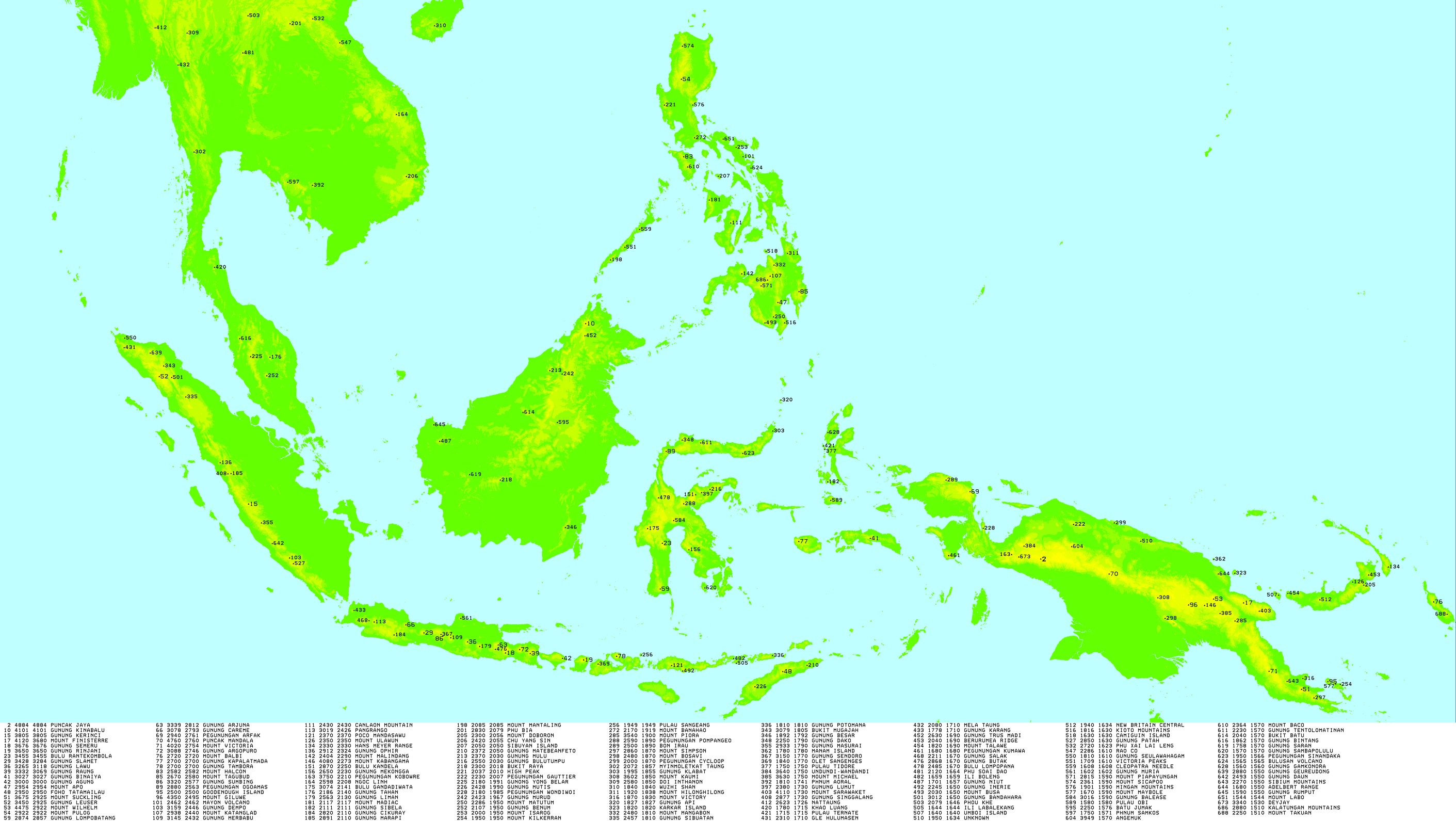
List of Ultras in Indonesia
Encyclopedia
This is a list of all the Ultra prominent peak
s (with topographic prominence
greater than 1,500 metres) in the Indonesia
n archipelago.
Sumatra

Java
Lesser Sunda Islands
Borneo
Sulawesi
Papua
Ultra prominent peak
An ultra prominent peak, or Ultra for short, is a mountain with a topographic prominence of or more. There are a total of roughly 1,524 such peaks in the world. Some are famous even to non-climbers, such as Mount Everest, Aconcagua, and Mount McKinley , while others are much more obscure...
s (with topographic prominence
Topographic prominence
In topography, prominence, also known as autonomous height, relative height, shoulder drop , or prime factor , categorizes the height of the mountain's or hill's summit by the elevation between it and the lowest contour line encircling it and no higher summit...
greater than 1,500 metres) in the Indonesia
Indonesia
Indonesia , officially the Republic of Indonesia , is a country in Southeast Asia and Oceania. Indonesia is an archipelago comprising approximately 13,000 islands. It has 33 provinces with over 238 million people, and is the world's fourth most populous country. Indonesia is a republic, with an...
n archipelago.
SumatraSumatraSumatra is an island in western Indonesia, westernmost of the Sunda Islands. It is the largest island entirely in Indonesia , and the sixth largest island in the world at 473,481 km2 with a population of 50,365,538...
| No | Peak | Country | Elevation (m) | Prominence (m) | Col (m) |
|---|---|---|---|---|---|
| 1 | Mount Kerinci Mount Kerinci Mount Kerinci is the highest volcano in Indonesia, and the highest peak on the island of Sumatra... |
(Sumatra Sumatra Sumatra is an island in western Indonesia, westernmost of the Sunda Islands. It is the largest island entirely in Indonesia , and the sixth largest island in the world at 473,481 km2 with a population of 50,365,538... ) |
3,805 | 3,805 | 0 |
| 2 | Mount Leuser Mount Leuser Mount Leuser is the tallest mountain in the Indonesian province of Aceh, with an elevation of .The Gunung Leuser National Park protects the mountain and its surrounding ecosystems. It has been confirmed by some scientists that 2004 Indian Ocean earthquake has activated the volcano... |
(Sumatra Sumatra Sumatra is an island in western Indonesia, westernmost of the Sunda Islands. It is the largest island entirely in Indonesia , and the sixth largest island in the world at 473,481 km2 with a population of 50,365,538... ) |
3,466 | 2,891 | 525 |
| 3 | Mount Dempo Mount Dempo Mount Dempo is a high stratovolcano that rises above Pasumah Plain in the province of South Sumatra in Sumatra, Indonesia. Seven craters are found around the summit. A 400 m wide lake is found at the northwest end of the crater complex.... |
(Sumatra Sumatra Sumatra is an island in western Indonesia, westernmost of the Sunda Islands. It is the largest island entirely in Indonesia , and the sixth largest island in the world at 473,481 km2 with a population of 50,365,538... ) |
3,159 | 2,446 | 713 |
| 4 | Mount Ophir Mount Ophir Mount Ophir, or more commonly known by its Malay name, Gunung Ledang, is a mountain situated in the Gunung Ledang National Park located in Ledang District , Malaysia. The summit is located between the border of Muar and Malacca. Standing at 1,276 m , with a clear trail leading to the peak, the... |
(Sumatra Sumatra Sumatra is an island in western Indonesia, westernmost of the Sunda Islands. It is the largest island entirely in Indonesia , and the sixth largest island in the world at 473,481 km2 with a population of 50,365,538... ) |
2,912 | 2,324 | 588 |
| 5 | Mount Marapi Mount Marapi Marapi is a complex volcano in West Sumatra, Indonesia. Its name means Mountain of Fire, and it is the most active volcano in Sumatra. Its elevation is... |
(Sumatra Sumatra Sumatra is an island in western Indonesia, westernmost of the Sunda Islands. It is the largest island entirely in Indonesia , and the sixth largest island in the world at 473,481 km2 with a population of 50,365,538... ) |
2,891 | 2,116 | 775 |
| 6 | Bukit Mugajah | (Sumatra Sumatra Sumatra is an island in western Indonesia, westernmost of the Sunda Islands. It is the largest island entirely in Indonesia , and the sixth largest island in the world at 473,481 km2 with a population of 50,365,538... ) |
3,079 | 1,805 | 1274 |
| 7 | Mount Sibuatan | (Sumatra Sumatra Sumatra is an island in western Indonesia, westernmost of the Sunda Islands. It is the largest island entirely in Indonesia , and the sixth largest island in the world at 473,481 km2 with a population of 50,365,538... ) |
2,457 | 1,802 | 655 |
| 8 | Mount Masurai | (Sumatra Sumatra Sumatra is an island in western Indonesia, westernmost of the Sunda Islands. It is the largest island entirely in Indonesia , and the sixth largest island in the world at 473,481 km2 with a population of 50,365,538... ) |
2,933 | 1,791 | 1142 |
| 9 | Mount Singgalang Mount Singgalang Singgalang is a volcano in West Sumatra, Indonesia. Its elevation is 2,877 m . It is a twin volcano with Mount Tandikat, which is located to the south-south-west of Singgalang. However, only Tandikat has had historical volcanic activity... |
(Sumatra Sumatra Sumatra is an island in western Indonesia, westernmost of the Sunda Islands. It is the largest island entirely in Indonesia , and the sixth largest island in the world at 473,481 km2 with a population of 50,365,538... ) |
2,877 | 1,727 | 1150 |
| 10 | Gle Hulumasen | (Sumatra Sumatra Sumatra is an island in western Indonesia, westernmost of the Sunda Islands. It is the largest island entirely in Indonesia , and the sixth largest island in the world at 473,481 km2 with a population of 50,365,538... ) |
2,310 | 1,720 | 590 |
| 11 | Mount Bandahara | (Sumatra Sumatra Sumatra is an island in western Indonesia, westernmost of the Sunda Islands. It is the largest island entirely in Indonesia , and the sixth largest island in the world at 473,481 km2 with a population of 50,365,538... ) |
3,012 | 1,644 | 1368 |
| 12 | Seulawah Agam Seulawah Agam Seulawah Agam is an extensive forested stratovolcano located at the northwestern tip of Sumatra. Several names have been given to the mountain: Seulawaih Agam, Seulawain Agam, Solawa Agam, Solawaik Agam, Selawadjanten and Goldberg.The volcano was constructed during the Pleistocene-Holocene age. The... |
(Sumatra Sumatra Sumatra is an island in western Indonesia, westernmost of the Sunda Islands. It is the largest island entirely in Indonesia , and the sixth largest island in the world at 473,481 km2 with a population of 50,365,538... ) |
1,810 | 1,610 | 200 |
| 13 | Mount Patah Mount Patah Mount Patah is a heavily forested quaternary age volcano west of Mount Dempo on Sumatra island, Indonesia. On 1 May 1989, a fumarole activity was observed by a pilot near the summit. The exact location of the crater, the date of its formation and its geologic relationship is uncertain.... |
(Sumatra Sumatra Sumatra is an island in western Indonesia, westernmost of the Sunda Islands. It is the largest island entirely in Indonesia , and the sixth largest island in the world at 473,481 km2 with a population of 50,365,538... ) |
2,850 | 1,635 | 1215 |
| 14 | Bur ni Geureudong | (Sumatra Sumatra Sumatra is an island in western Indonesia, westernmost of the Sunda Islands. It is the largest island entirely in Indonesia , and the sixth largest island in the world at 473,481 km2 with a population of 50,365,538... ) |
2,880 | 1,546 | 1334 |
| 15 | Bukit Daun Bukit Daun Bukit Daun is a stratovolcano, located in a sparsely populated region in Sumatra, Indonesia. A 600 m wide of crater lake is located at the summit. A smaller crater lake, Tologo Kecil, is found in the southwest flank.... |
(Sumatra Sumatra Sumatra is an island in western Indonesia, westernmost of the Sunda Islands. It is the largest island entirely in Indonesia , and the sixth largest island in the world at 473,481 km2 with a population of 50,365,538... ) |
2,493 | 1,541 | 952 |
JavaJavaJava is an island of Indonesia. With a population of 135 million , it is the world's most populous island, and one of the most densely populated regions in the world. It is home to 60% of Indonesia's population. The Indonesian capital city, Jakarta, is in west Java...
| No | Peak | Country | Elevation (m) | Prominence (m) | Col (m) |
|---|---|---|---|---|---|
| 1 | Semeru Semeru Semeru, or Mount Semeru , is a volcano located in East Java, Indonesia. It is the highest mountain on the island of Java... |
(Java Java Java is an island of Indonesia. With a population of 135 million , it is the world's most populous island, and one of the most densely populated regions in the world. It is home to 60% of Indonesia's population. The Indonesian capital city, Jakarta, is in west Java... ) |
3,676 | 3,676 | 0 |
| 2 | Mount Slamet Mount Slamet Mount Slamet or Gunung Slamet is an active stratovolcano in Central Java, Indonesia. It has a cluster of around three dozens of cinder cones on the lower southeast-northeast flanks and a single cinder cone on the western flank. The volcano is composed by two overlapping edifices. Four craters are... |
(Java Java Java is an island of Indonesia. With a population of 135 million , it is the world's most populous island, and one of the most densely populated regions in the world. It is home to 60% of Indonesia's population. The Indonesian capital city, Jakarta, is in west Java... ) |
3,428 | 3,284 | 144 |
| 3 | Mount Lawu Mount Lawu Mount Lawu, or Gunung Lawu, is a massive compound stratovolcano straddling the border between East Java and Central Java, Indonesia. The north side is deeply eroded and the eastern side contains parasitic crater lakes and parasitic cones. A fumarolic area is located on the south flank at 2,550 m... |
(Java Java Java is an island of Indonesia. With a population of 135 million , it is the world's most populous island, and one of the most densely populated regions in the world. It is home to 60% of Indonesia's population. The Indonesian capital city, Jakarta, is in west Java... ) |
3,265 | 3,118 | 147 |
| 4 | Raung Raung Raung is one of the most active volcanoes on the island of Java in Indonesia.It is located in the province of East Java and has a wide caldera surrounded by a grayish rim. The difference in color of the rim and the flanks of the volcanoes is caused by the rim’s lack of vegetation compared with the... |
(Java Java Java is an island of Indonesia. With a population of 135 million , it is the world's most populous island, and one of the most densely populated regions in the world. It is home to 60% of Indonesia's population. The Indonesian capital city, Jakarta, is in west Java... ) |
3,332 | 3,069 | 263 |
| 5 | Arjuno-Welirang Arjuno-Welirang Arjuno-Welirang is a stratovolcano in the province of East Java on Java, Indonesia. It is a twin volcano, with the 'twins' being Arjuno and Welirang. There is at least one other stratovolcano in the area, and there are around 10 pyroclastic cones nearby. They are located in a 6 km line between... |
(Java Java Java is an island of Indonesia. With a population of 135 million , it is the world's most populous island, and one of the most densely populated regions in the world. It is home to 60% of Indonesia's population. The Indonesian capital city, Jakarta, is in west Java... ) |
3,339 | 2,812 | 527 |
| 6 | Mount Cereme Mount Cereme Mount Cereme or Mount Ciremai is a symmetrical stratovolcano lies in West Java, Indonesia. A 4.5 × 5 km wide of the Geger Halang caldera is found at the summit. Eruptions are relatively infrequent in historical time, but explosive activity and lahars from the summit have been recorded.... |
(Java Java Java is an island of Indonesia. With a population of 135 million , it is the world's most populous island, and one of the most densely populated regions in the world. It is home to 60% of Indonesia's population. The Indonesian capital city, Jakarta, is in west Java... ) |
3,078 | 2,793 | 285 |
| 7 | Iyang-Argapura Iyang-Argapura Iyang-Argapura is a massive volcanic complex that dominates the landscape between Mount Raung and Mount Lamongan in East Java, Indonesia. Valleys up to 1,000 m deep dissect the strongly eroded Iyang volcano. No historical eruptions recorded for at least the last 500 years. Unverified report... |
(Java Java Java is an island of Indonesia. With a population of 135 million , it is the world's most populous island, and one of the most densely populated regions in the world. It is home to 60% of Indonesia's population. The Indonesian capital city, Jakarta, is in west Java... ) |
3,088 | 2,746 | 342 |
| 8 | Mount Sumbing Mount Sumbing Mount Sumbing or Gunung Sumbing is an active stratovolcano in Central Java, Indonesia, symmetrical with Sundoro. The only report of historical eruptions is from 1730. It has created a small phreatic crater at the summit.... |
(Java Java Java is an island of Indonesia. With a population of 135 million , it is the world's most populous island, and one of the most densely populated regions in the world. It is home to 60% of Indonesia's population. The Indonesian capital city, Jakarta, is in west Java... ) |
3,320 | 2,577 | 743 |
| 9 | Mount Merbabu Mount Merbabu Mount Merbabu is a dormant stratovolcano in Central Java province on the Indonesian island of Java. The name Merbabu could be loosely translated as 'Mountain of Ash' from the Javanese combined words; Meru means "mountain" and awu or abu means "ash".The active volcano Mount Merapi is directly... |
(Java Java Java is an island of Indonesia. With a population of 135 million , it is the world's most populous island, and one of the most densely populated regions in the world. It is home to 60% of Indonesia's population. The Indonesian capital city, Jakarta, is in west Java... ) |
3,145 | 2,432 | 713 |
| 10 | Pangrango | (Java Java Java is an island of Indonesia. With a population of 135 million , it is the world's most populous island, and one of the most densely populated regions in the world. It is home to 60% of Indonesia's population. The Indonesian capital city, Jakarta, is in west Java... ) |
3,019 | 2,426 | 593 |
| 11 | Mount Liman | (Java Java Java is an island of Indonesia. With a population of 135 million , it is the world's most populous island, and one of the most densely populated regions in the world. It is home to 60% of Indonesia's population. The Indonesian capital city, Jakarta, is in west Java... ) |
2,563 | 2,131 | 432 |
| 12 | Mount Cikuray | (Java Java Java is an island of Indonesia. With a population of 135 million , it is the world's most populous island, and one of the most densely populated regions in the world. It is home to 60% of Indonesia's population. The Indonesian capital city, Jakarta, is in west Java... ) |
2,820 | 2,103 | 717 |
| 13 | Mount Sundoro Mount Sundoro Mount Sindara, Mount Sindoro or Mount Sundoro is an active stratovolcano in Central Java, Indonesia. Parasitic craters and cones are found in the northwest-southern flanks; the largest is called Kembang. A small lava dome occupies the volcano's summit. Historical eruptions mostly mild-to-moderate... |
(Java Java Java is an island of Indonesia. With a population of 135 million , it is the world's most populous island, and one of the most densely populated regions in the world. It is home to 60% of Indonesia's population. The Indonesian capital city, Jakarta, is in west Java... ) |
3,150 | 1,760 | 1390 |
| 14 | Karang Karang Mount Karang or Gunung Karang is a volcano at the western most end of West Java, Indonesia.-References:... |
(Java Java Java is an island of Indonesia. With a population of 135 million , it is the world's most populous island, and one of the most densely populated regions in the world. It is home to 60% of Indonesia's population. The Indonesian capital city, Jakarta, is in west Java... ) |
1,778 | 1,703 | 75 |
| 15 | Mount Salak Mount Salak Mount Salak is an eroded volcanic range in West Java, Indonesia. Several satellite cones occur on the southeast flank and on the northern foot. Two craters are found at the summit. Mount Salak has been the site of a geothermal exploration.. The name Salak is come from salak fruit.- See also :*... |
(Java Java Java is an island of Indonesia. With a population of 135 million , it is the world's most populous island, and one of the most densely populated regions in the world. It is home to 60% of Indonesia's population. The Indonesian capital city, Jakarta, is in west Java... ) |
2,211 | 1,678 | 533 |
| 16 | Mount Butak Mount Butak Mount Butak is a stratovolcano in East Java province on Java island, Indonesia. It is a massive volcano, adjacent to Mount Kawi. There are no historical records of its eruptions.... |
(Java Java Java is an island of Indonesia. With a population of 135 million , it is the world's most populous island, and one of the most densely populated regions in the world. It is home to 60% of Indonesia's population. The Indonesian capital city, Jakarta, is in west Java... ) |
2,868 | 1,675 | 1193 |
| 17 | Mount Muria Mount Muria Mount Muria or Gunung Muria is a dormant volcano on the north coast of Java, Indonesia.The area is notable for a number of reasons. It is the site of the grave of one of the Wali Sanga of Java - Sunan Muria - one of the Islamic Saints associated with the origins of Islam in Java... |
(Java Java Java is an island of Indonesia. With a population of 135 million , it is the world's most populous island, and one of the most densely populated regions in the world. It is home to 60% of Indonesia's population. The Indonesian capital city, Jakarta, is in west Java... ) |
1,602 | 1,595 | 7 |
Lesser Sunda IslandsLesser Sunda IslandsThe Lesser Sunda Islands or Nusa Tenggara are a group of islands in the southern Maritime Southeast Asia, north of Australia. Together with the Greater Sunda Islands to the west they make up the Sunda Islands...
| No | Peak | Country | Elevation (m) | Prominence (m) | Col (m) |
|---|---|---|---|---|---|
| 1 | Mount Rinjani Mount Rinjani Mount Rinjani or Gunung Rinjani is an active volcano in Indonesia on the island of Lombok. Administratively the mountain is in the Regency of North Lombok, West Nusa Tenggara... |
(Lombok Lombok Lombok is an island in West Nusa Tenggara province, Indonesia. It forms part of the chain of the Lesser Sunda Islands, with the Lombok Strait separating it from Bali to the west and the Alas Strait between it and Sumbawa to the east... ) |
3,726 | 3,726 | 0 |
| 2 | Mount Agung Mount Agung Mount Agung or Gunung Agung is a mountain in Bali, Indonesia. This stratovolcano is the highest point on the island. It dominates the surrounding area influencing the climate... |
(Bali Bali Bali is an Indonesian island located in the westernmost end of the Lesser Sunda Islands, lying between Java to the west and Lombok to the east... ) |
3,019 | 3,019 | 0 |
| 3 | Mount Ramelau Mount Ramelau Tatamailau , sometimes referred as Mount Ramelau, is the highest mountain in East Timor and also of Timor island at 2,963 m . The mountain is located approximately 70 km of the capital Dili in the district of Ainaro... |
2,986 | 2,986 | 0 | |
| 4 | Mount Tambora Mount Tambora Mount Tambora is an active stratovolcano, also known as a composite volcano, on the island of Sumbawa, Indonesia. Sumbawa is flanked both to the north and south by oceanic crust, and Tambora was formed by the active subduction zone beneath it. This raised Mount Tambora as high as , making it... |
(Sumbawa Sumbawa Sumbawa is an Indonesian island, located in the middle of the Lesser Sunda Islands chain, with Lombok to the west, Flores to the east, and Sumba further to the southeast. It is in the province of West Nusa Tenggara.... ) |
2,722 | 2,722 | 0 |
| 5 | Poco Mandasawu Poco Mandasawu Poco Mandasawu is a mountain located in the south-central part of the island of Flores, Indonesia. It is the highest point of the island.... |
(Flores Flores Flores is one of the Lesser Sunda Islands, an island arc with an estimated area of 14,300 km² extending east from the Java island of Indonesia. The population was 1.831.000 in the 2010 census and the largest town is Maumere. Flores is Portuguese for "flowers".Flores is located east of Sumbawa... ) |
2,370 | 2,370 | 0 |
| 6 | Gunung Matebeanfeto | 2,372 | 2,022 | 350 | |
| 7 | Sangeang Api | (Sangeang Api) | 1,949 | 1,949 | 0 |
| 8 | Nuaf Nefomasi | (Timor Timor Timor is an island at the southern end of Maritime Southeast Asia, north of the Timor Sea. It is divided between the independent state of East Timor, and West Timor, belonging to the Indonesian province of East Nusa Tenggara. The island's surface is 30,777 square kilometres... ) |
2,351 | 1,905 | 446 |
| 9 | Dola Koyakoya | (Alor) | 1,821 | 1,821 | 0 |
| 10 | Olet Sangenges | (Sumbawa Sumbawa Sumbawa is an Indonesian island, located in the middle of the Lesser Sunda Islands chain, with Lombok to the west, Flores to the east, and Sumba further to the southeast. It is in the province of West Nusa Tenggara.... ) |
1,840 | 1,773 | 67 |
| 11 | Ili Boleng | (Adonara Adonara Adonara is an island in the Lesser Sunda Islands of Indonesia, located east of the larger island of Flores in the Solor Archipelago. To the east lies Lembata, formerly known as Lomblen. It is the highest of the islands of the archipelago, reaching an altitude of 1,659 metres, and it has an area of... ) |
1,661 | 1,661 | 0 |
| 12 | Ili Labalekang | (Lembata Lembata Lembata is an island in the Lesser Sunda Islands, formerly known as Lomblen island, is the largest island of the Solor Archipelago, in the Lesser Sunda Islands, Indonesia. It forms part of the province of Nusa Tenggara Timur. The length of the island is about 80 km from the Southwest to the... ) |
1,644 | 1,644 | 0 |
| 13 | Gunung Inerie | (Sumbawa Sumbawa Sumbawa is an Indonesian island, located in the middle of the Lesser Sunda Islands chain, with Lombok to the west, Flores to the east, and Sumba further to the southeast. It is in the province of West Nusa Tenggara.... ) |
2,245 | 1,643 | 602 |
BorneoBorneoBorneo is the third largest island in the world and is located north of Java Island, Indonesia, at the geographic centre of Maritime Southeast Asia....
| No | Peak | Country | Elevation (m) | Prominence (m) | Col (m) |
|---|---|---|---|---|---|
| 1 | Mount Kinabalu Mount Kinabalu Mount Kinabalu is a prominent mountain on the island of Borneo in Southeast Asia. It is located in the East Malaysian state of Sabah and is protected as Kinabalu National Park, a World Heritage Site. Kinabalu is the tallest peak in Borneo's Crocker Range and is the tallest mountain in the Malay... |
(Borneo Borneo Borneo is the third largest island in the world and is located north of Java Island, Indonesia, at the geographic centre of Maritime Southeast Asia.... ) |
4,095 | 4,095 | 0 |
| 2 | Mount Mulu Mount Mulu Mount Mulu is a sandstone and shale mountain. At 2376 m, it is the second highest mountain in the state of Sarawak, after Mount Murud. It is located within the boundaries of Gunung Mulu National Park, which is named after it.... |
(Borneo Borneo Borneo is the third largest island in the world and is located north of Java Island, Indonesia, at the geographic centre of Maritime Southeast Asia.... ) |
2,376 | 2,024 | 352 |
| 3 | Bukit Raya | (Borneo Borneo Borneo is the third largest island in the world and is located north of Java Island, Indonesia, at the geographic centre of Maritime Southeast Asia.... ) |
2,300 | 2,018 | 282 |
| 4 | Mount Murud Mount Murud Mount Murud or Muru is a sandstone mountain located in the Malaysian part of Borneo. At 2,423 m , it is the highest mountain in the state of Sarawak.... |
(Borneo Borneo Borneo is the third largest island in the world and is located north of Java Island, Indonesia, at the geographic centre of Maritime Southeast Asia.... ) |
2,423 | 1,967 | 456 |
| 5 | Mount Besar Mount Besar Mount Besar is a stratovolcano in the southeast of Sumatra, Indonesia. A minor sulfur deposit can be found in the crater. A big solfatara field called Marga Bayur is located along its north-southwest flanks or the Semangko fault system.... |
(Borneo Borneo Borneo is the third largest island in the world and is located north of Java Island, Indonesia, at the geographic centre of Maritime Southeast Asia.... ) |
1,892 | 1,792 | 100 |
| 6 | Mount Trusmadi | (Borneo Borneo Borneo is the third largest island in the world and is located north of Java Island, Indonesia, at the geographic centre of Maritime Southeast Asia.... ) |
2,643 | 1,703 | 940 |
| 7 | Mount Niut | (Borneo Borneo Borneo is the third largest island in the world and is located north of Java Island, Indonesia, at the geographic centre of Maritime Southeast Asia.... ) |
1,701 | 1,661 | 40 |
| 8 | Batu Jumak | (Borneo Borneo Borneo is the third largest island in the world and is located north of Java Island, Indonesia, at the geographic centre of Maritime Southeast Asia.... ) |
2,250 | 1,576 | 674 |
| 9 | Bukit Batu Bukit Batu Bukit Batu is a small town in the north tips of Kulaijaya District. Majlis Perbandaran Kulai administrated the town.... |
(Borneo Borneo Borneo is the third largest island in the world and is located north of Java Island, Indonesia, at the geographic centre of Maritime Southeast Asia.... ) |
2,040 | 1,572 | 468 |
| 10 | Mount Saran | (Borneo Borneo Borneo is the third largest island in the world and is located north of Java Island, Indonesia, at the geographic centre of Maritime Southeast Asia.... ) |
1,758 | 1,571 | 187 |
| 11 | Mount Rumput Mount Rumput Mount Rumput is a mountain on the island of Borneo. It is 1590 metres tall and sits on the international border between Indonesia and Malaysia.... |
/ (Borneo Borneo Borneo is the third largest island in the world and is located north of Java Island, Indonesia, at the geographic centre of Maritime Southeast Asia.... ) |
1590 | 1,560 | 674 |
SulawesiSulawesiSulawesi is one of the four larger Sunda Islands of Indonesia and is situated between Borneo and the Maluku Islands. In Indonesia, only Sumatra, Borneo, and Papua are larger in territory, and only Java and Sumatra have larger Indonesian populations.- Etymology :The Portuguese were the first to...
| No | Peak | Country | Elevation (m) | Prominence (m) | Col (m) |
|---|---|---|---|---|---|
| 1 | Mount Rantemario | (Sulawesi Sulawesi Sulawesi is one of the four larger Sunda Islands of Indonesia and is situated between Borneo and the Maluku Islands. In Indonesia, only Sumatra, Borneo, and Papua are larger in territory, and only Java and Sumatra have larger Indonesian populations.- Etymology :The Portuguese were the first to... ) |
3,478 | 3,478 | 0 |
| 2 | Moncong Lompobatang | (Sulawesi Sulawesi Sulawesi is one of the four larger Sunda Islands of Indonesia and is situated between Borneo and the Maluku Islands. In Indonesia, only Sumatra, Borneo, and Papua are larger in territory, and only Java and Sumatra have larger Indonesian populations.- Etymology :The Portuguese were the first to... ) |
2,874 | 2,857 | 17 |
| 3 | Fuyul Sojol | (Sulawesi Sulawesi Sulawesi is one of the four larger Sunda Islands of Indonesia and is situated between Borneo and the Maluku Islands. In Indonesia, only Sumatra, Borneo, and Papua are larger in territory, and only Java and Sumatra have larger Indonesian populations.- Etymology :The Portuguese were the first to... ) |
3,030 | 2,713 | 317 |
| 4 | Bulu Kandela | (Sulawesi Sulawesi Sulawesi is one of the four larger Sunda Islands of Indonesia and is situated between Borneo and the Maluku Islands. In Indonesia, only Sumatra, Borneo, and Papua are larger in territory, and only Java and Sumatra have larger Indonesian populations.- Etymology :The Portuguese were the first to... ) |
2,870 | 2,258 | 612 |
| 5 | Mount Mekongga | (Sulawesi Sulawesi Sulawesi is one of the four larger Sunda Islands of Indonesia and is situated between Borneo and the Maluku Islands. In Indonesia, only Sumatra, Borneo, and Papua are larger in territory, and only Java and Sumatra have larger Indonesian populations.- Etymology :The Portuguese were the first to... ) |
2,650 | 2,220 | 430 |
| 6 | Tanete Gandangdewata | (Sulawesi Sulawesi Sulawesi is one of the four larger Sunda Islands of Indonesia and is situated between Borneo and the Maluku Islands. In Indonesia, only Sumatra, Borneo, and Papua are larger in territory, and only Java and Sumatra have larger Indonesian populations.- Etymology :The Portuguese were the first to... ) |
3,074 | 2,141 | 933 |
| 7 | Mount Tumpu | (Sulawesi Sulawesi Sulawesi is one of the four larger Sunda Islands of Indonesia and is situated between Borneo and the Maluku Islands. In Indonesia, only Sumatra, Borneo, and Papua are larger in territory, and only Java and Sumatra have larger Indonesian populations.- Etymology :The Portuguese were the first to... ) |
2,565 | 2,054 | 511 |
| 8 | Pegunungan Pompangeo | (Sulawesi Sulawesi Sulawesi is one of the four larger Sunda Islands of Indonesia and is situated between Borneo and the Maluku Islands. In Indonesia, only Sumatra, Borneo, and Papua are larger in territory, and only Java and Sumatra have larger Indonesian populations.- Etymology :The Portuguese were the first to... ) |
2,590 | 1,881 | 709 |
| 9 | Mount Klabat Mount Klabat Mount Klabat is the highest volcano on Sulawesi island, located in the east of Manado city, North Sulawesi, Indonesia. A 170 × 250 m wide, shallow crater lake is found at the summit. There are no confirmed historical eruptions of the volcano. A report of eruption taking place in 1683 is... |
(Sulawesi Sulawesi Sulawesi is one of the four larger Sunda Islands of Indonesia and is situated between Borneo and the Maluku Islands. In Indonesia, only Sumatra, Borneo, and Papua are larger in territory, and only Java and Sumatra have larger Indonesian populations.- Etymology :The Portuguese were the first to... ) |
1,990 | 1,850 | 140 |
| 10 | Karangetang Karangetang Karangetang is a volcano located on the north side of Siau Island in Indonesia. The island is inhabited by 22,000 people. It is one of the most active volcanoes in Indonesia having erupted forty-one times since 1675... |
(Siau) | 1,827 | 1,827 | 0 |
| 11 | Bukii Dako | (Sulawesi Sulawesi Sulawesi is one of the four larger Sunda Islands of Indonesia and is situated between Borneo and the Maluku Islands. In Indonesia, only Sumatra, Borneo, and Papua are larger in territory, and only Java and Sumatra have larger Indonesian populations.- Etymology :The Portuguese were the first to... ) |
2,260 | 1,801 | 459 |
| 12 | Buyu Lumut | (Sulawesi Sulawesi Sulawesi is one of the four larger Sunda Islands of Indonesia and is situated between Borneo and the Maluku Islands. In Indonesia, only Sumatra, Borneo, and Papua are larger in territory, and only Java and Sumatra have larger Indonesian populations.- Etymology :The Portuguese were the first to... ) |
2,403 | 1,757 | 646 |
| 13 | Bulu Torompupu | (Sulawesi Sulawesi Sulawesi is one of the four larger Sunda Islands of Indonesia and is situated between Borneo and the Maluku Islands. In Indonesia, only Sumatra, Borneo, and Papua are larger in territory, and only Java and Sumatra have larger Indonesian populations.- Etymology :The Portuguese were the first to... ) |
2,463 | 1,651 | 812 |
| 14 | Buyu Balease | (Sulawesi Sulawesi Sulawesi is one of the four larger Sunda Islands of Indonesia and is situated between Borneo and the Maluku Islands. In Indonesia, only Sumatra, Borneo, and Papua are larger in territory, and only Java and Sumatra have larger Indonesian populations.- Etymology :The Portuguese were the first to... ) |
3,016 | 1,588 | 1428 |
| 15 | Huidu Matabulawa | (Sulawesi Sulawesi Sulawesi is one of the four larger Sunda Islands of Indonesia and is situated between Borneo and the Maluku Islands. In Indonesia, only Sumatra, Borneo, and Papua are larger in territory, and only Java and Sumatra have larger Indonesian populations.- Etymology :The Portuguese were the first to... ) |
1,964 | 1,580 | 384 |
| 16 | Mount Sambapolulu | (Kabaena Kabaena Kabaena is an island in the Flores Sea, Indonesia, off the coast of Sulawesi. It is a part of South East Sulawesi province. Its area is 873 km².... ) |
1,570 | 1,570 | 0 |
| 17 | Huidu Tentolomatinan | (Sulawesi Sulawesi Sulawesi is one of the four larger Sunda Islands of Indonesia and is situated between Borneo and the Maluku Islands. In Indonesia, only Sumatra, Borneo, and Papua are larger in territory, and only Java and Sumatra have larger Indonesian populations.- Etymology :The Portuguese were the first to... ) |
2,230 | 1,565 | 665 |
Molucca Islands
| No | Peak | Country | Elevation (m) | Prominence (m) | Col (m) |
|---|---|---|---|---|---|
| 1 | Mount Binaiya Mount Binaiya Mount Binaiya is the highest point on the Indonesian island of Seram . At an elevation of , it is one of the one hundred most topographically prominent peaks on Earth.... |
(Seram Seram Seram is an island in the Maluku province of Indonesia. It is located north of Ambon Island. The chief port/town is Masohi.- Geography and geology :... ) |
3,027 | 3,027 | 0 |
| 2 | Mount Kapalatmada | (Buru Buru Buru is the third largest island within Maluku Islands of Malay Archipelago. It lies between the Banda Sea to the south and Seram Sea to the north, west of Ambon and Seram islands. The island belongs to Maluku province of Indonesia and includes the Buru and South Buru regencies... ) |
2,700 | 2,700 | 0 |
| 3 | Buku Sibela | (Bacan Bacan Bacan refers to a group of islands in the Maluku Islands of Indonesia and to that group's largest island. The islands are mountainous and forested. The islands lie south of Ternate and west of Halmahera's southernmost arm... ) |
2,111 | 2,111 | 0 |
| 4 | Pulau Tidore | (Tidore Tidore Tidore is a city, island, and archipelago in the Maluku Islands of eastern Indonesia, west of the larger island of Halmahera. In the pre-colonial era, the kingdom of Tidore was a major regional political and economic power, and a fierce rival of nearby Ternate, just to the north.-Geography:Tidor... ) |
1,750 | 1,750 | 0 |
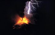
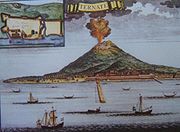
| 5 | Gamalama Gamalama Gamalama is a near-conical stratovolcano that comprises the entire Ternate island in Indonesia. The island lies off the western shore of Halmahera island in the north of Molucca Islands. For centuries, Ternate was a center of Portuguese and Dutch forts for spice trade, which have accounted for... |
(Ternate Ternate Ternate is an island in the Maluku Islands of eastern Indonesia. It is located off the west coast of the larger island of Halmahera, the center of the powerful former Sultanate of Ternate.... ) |
1,715 | 1,715 | 0 |
| 6 | Pulau Obi | (Obi Obi Islands The Obi Islands are a group of islands in the Indonesian province of Maluku. They lie north of Buru and Ceram.... ) |
1,611 | 1,611 | 0 |
| 7 | Mount Gamkonora Mount Gamkonora Mount Gamkonora is the highest peak of Halmahera island, Indonesia. It has produced an elongated series of craters along the north-south rift. The largest eruption in 1673 was accompanied with tsunami which inundated the nearby villages... |
(Halmahera Halmahera Halmahera is the largest island in the Maluku Islands. It is part of the North Maluku province of Indonesia.Halmahera has a land area of 17,780 km² and a population in 1995 of 162,728... ) |
1,560 | 1,560 | 0 |
PapuaPapua (Indonesian province)Papua comprises most of the western half of the island of New Guinea and nearby islands. Its capital is Jayapura. It's the largest and easternmost province of Indonesia. The province originally covered the entire western half of New Guinea...
| No | Peak | Country | Elevation (m) | Prominence (m) | Col (m) |
|---|---|---|---|---|---|
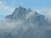
| 1 | Puncak Jaya Puncak Jaya Puncak Jaya or Carstensz Pyramid is the highest summit of Mount Carstensz in the Sudirman Range of the western central highlands of Papua province, Indonesia . Other summits are East Carstensz Peak and Ngga Pulu... |
(New Guinea New Guinea New Guinea is the world's second largest island, after Greenland, covering a land area of 786,000 km2. Located in the southwest Pacific Ocean, it lies geographically to the east of the Malay Archipelago, with which it is sometimes included as part of a greater Indo-Australian Archipelago... ) |
4,884 | 4,884 | 0 |
| 2 | Mount Arfak | (New Guinea New Guinea New Guinea is the world's second largest island, after Greenland, covering a land area of 786,000 km2. Located in the southwest Pacific Ocean, it lies geographically to the east of the Malay Archipelago, with which it is sometimes included as part of a greater Indo-Australian Archipelago... ) |
2,940 | 2,761 | 179 |
| 3 | Puncak Mandala Puncak Mandala Puncak Mandala , is a mountain located in Papua, Indonesia. Following Mount Carstensz 350 km to the east, Mandala is the second highest freestanding mountain of Oceania, Australasia, New Guinea and Indonesia.-Further reading:* at GunungBagging.com... |
(New Guinea New Guinea New Guinea is the world's second largest island, after Greenland, covering a land area of 786,000 km2. Located in the southwest Pacific Ocean, it lies geographically to the east of the Malay Archipelago, with which it is sometimes included as part of a greater Indo-Australian Archipelago... ) |
4,760 | 2,760 | 2000 |
| 4 | Mount Kobowre | (New Guinea New Guinea New Guinea is the world's second largest island, after Greenland, covering a land area of 786,000 km2. Located in the southwest Pacific Ocean, it lies geographically to the east of the Malay Archipelago, with which it is sometimes included as part of a greater Indo-Australian Archipelago... ) |
3,750 | 2,217 | 1533 |
| 5 | Mount Gauttier | (New Guinea New Guinea New Guinea is the world's second largest island, after Greenland, covering a land area of 786,000 km2. Located in the southwest Pacific Ocean, it lies geographically to the east of the Malay Archipelago, with which it is sometimes included as part of a greater Indo-Australian Archipelago... ) |
2,230 | 2,007 | 223 |
| 6 | Mount Wondiwoi | (New Guinea New Guinea New Guinea is the world's second largest island, after Greenland, covering a land area of 786,000 km2. Located in the southwest Pacific Ocean, it lies geographically to the east of the Malay Archipelago, with which it is sometimes included as part of a greater Indo-Australian Archipelago... ) |
2,180 | 1,985 | 195 |
| 7 | Bon Irau | (New Guinea New Guinea New Guinea is the world's second largest island, after Greenland, covering a land area of 786,000 km2. Located in the southwest Pacific Ocean, it lies geographically to the east of the Malay Archipelago, with which it is sometimes included as part of a greater Indo-Australian Archipelago... ) |
2,500 | 1,900 | 600 |
| 8 | Mount Cycloop | (New Guinea New Guinea New Guinea is the world's second largest island, after Greenland, covering a land area of 786,000 km2. Located in the southwest Pacific Ocean, it lies geographically to the east of the Malay Archipelago, with which it is sometimes included as part of a greater Indo-Australian Archipelago... ) |
2,000 | 1,876 | 124 |
| 9 | Undundi-Wandandi | (New Guinea New Guinea New Guinea is the world's second largest island, after Greenland, covering a land area of 786,000 km2. Located in the southwest Pacific Ocean, it lies geographically to the east of the Malay Archipelago, with which it is sometimes included as part of a greater Indo-Australian Archipelago... ) |
3,640 | 1,740 | 1900 |
| 10 | Mount Kumawa | (New Guinea New Guinea New Guinea is the world's second largest island, after Greenland, covering a land area of 786,000 km2. Located in the southwest Pacific Ocean, it lies geographically to the east of the Malay Archipelago, with which it is sometimes included as part of a greater Indo-Australian Archipelago... ) |
1,680 | 1,636 | 44 |
| 11 | Angemuk | (New Guinea New Guinea New Guinea is the world's second largest island, after Greenland, covering a land area of 786,000 km2. Located in the southwest Pacific Ocean, it lies geographically to the east of the Malay Archipelago, with which it is sometimes included as part of a greater Indo-Australian Archipelago... ) |
3,949 | 1,565 | 2384 |
| 12 | Deyjay | (New Guinea New Guinea New Guinea is the world's second largest island, after Greenland, covering a land area of 786,000 km2. Located in the southwest Pacific Ocean, it lies geographically to the east of the Malay Archipelago, with which it is sometimes included as part of a greater Indo-Australian Archipelago... ) |
3,340 | 1,555 | 1785 |