List of metropolitan areas in New Mexico
Encyclopedia

U.S. state
A U.S. state is any one of the 50 federated states of the United States of America that share sovereignty with the federal government. Because of this shared sovereignty, an American is a citizen both of the federal entity and of his or her state of domicile. Four states use the official title of...
of New Mexico
New Mexico
New Mexico is a state located in the southwest and western regions of the United States. New Mexico is also usually considered one of the Mountain States. With a population density of 16 per square mile, New Mexico is the sixth-most sparsely inhabited U.S...
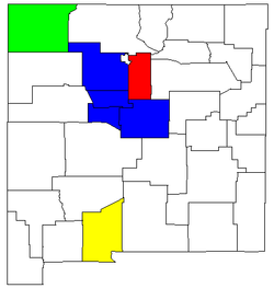
has a total of four metropolitan statistical areas (MSAs) that are fully or partially located in the state. 7 of the state's 33 counties are classified by the United States Census Bureau
United States Census Bureau
The United States Census Bureau is the government agency that is responsible for the United States Census. It also gathers other national demographic and economic data...
as metropolitan. As of the 2000 census
United States Census, 2000
The Twenty-second United States Census, known as Census 2000 and conducted by the Census Bureau, determined the resident population of the United States on April 1, 2000, to be 281,421,906, an increase of 13.2% over the 248,709,873 persons enumerated during the 1990 Census...
, these counties had a combined population 1,147,424 (63.1% of the state's total population). Based on a July 1, 2009 population estimate, that figure rose to 1,335,985 (66.5% of the state's total population).
Metropolitan areas
- Albuquerque MSAAlbuquerque metropolitan areaThe Albuquerque Metropolitan Statistical Area is a metropolitan area in central New Mexico centered on the city of Albuquerque that covers four counties - Bernalillo, Sandoval, Torrance, and Valencia. As of the 2000 census, the MSA had a population of 729,649...
- Bernalillo CountyBernalillo County, New Mexico-2010:Whereas according to the 2010 U.S. Census Bureau:*69.4% White*3.0% Black*4.8% Native American*2.3% Asian*0.1% Native Hawaiian or Pacific Islander*4.4% Two or more races*16.0% Other races*47.9% Hispanic or Latino -2000:...
- Sandoval CountySandoval County, New Mexico-Indian reservations:Sandoval County has 12 Indian reservations and two joint-use areas lying within its borders, the second most of any county in the United States -Indian reservations:Sandoval County has 12 Indian reservations and two joint-use areas lying within its borders, the second most of...
- Torrance CountyTorrance County, New Mexico-2010:Whereas according to the 2010 U.S. Census Bureau:*76.1% White*1.3% Black*2.3% Native American*0.4% Asian*0.0% Native Hawaiian or Pacific Islander*4.3% Two or more races*15.6% Other races*39.1% Hispanic or Latino -2000:...
- Valencia CountyValencia County, New Mexico-2010:Whereas according to the 2010 U.S. Census Bureau:*73.2% White*1.4% Black*3.8% Native American*0.5% Asian*0.1% Native Hawaiian or Pacific Islander*4.0% Two or more races*17.0% Other races*58.3% Hispanic or Latino -2000:...
- Bernalillo County
- Farmington MSASan Juan County, New Mexico-2010:Whereas according to the 2010 U.S. Census Bureau:*51.6% White*0.6% Black*36.6% Native American*0.4% Asian*0.1% Native Hawaiian or Pacific Islander*3.5% Two or more races*7.2% Other races*19.1% Hispanic or Latino -2000:...
- San Juan CountySan Juan County, New Mexico-2010:Whereas according to the 2010 U.S. Census Bureau:*51.6% White*0.6% Black*36.6% Native American*0.4% Asian*0.1% Native Hawaiian or Pacific Islander*3.5% Two or more races*7.2% Other races*19.1% Hispanic or Latino -2000:...
- San Juan County
- Las Cruces MSADoña Ana County, New Mexico-2010:Whereas according to the 2010 U.S. Census Bureau:*74.1% White*1.7% Black*1.5% Native American*1.1% Asian*0.1% Native Hawaiian or Pacific Islander*3.0% Two or more races*18.5% Other races*65.7% Hispanic or Latino -2000:...
- Doña Ana CountyDoña Ana County, New Mexico-2010:Whereas according to the 2010 U.S. Census Bureau:*74.1% White*1.7% Black*1.5% Native American*1.1% Asian*0.1% Native Hawaiian or Pacific Islander*3.0% Two or more races*18.5% Other races*65.7% Hispanic or Latino -2000:...
- Doña Ana County
- Santa Fe MSASanta Fe County, New Mexico-2010:Whereas according to the 2010 U.S. Census Bureau:*76.2% White*0.9% Black*3.1% Native American*1.2% Asian*0.1% Native Hawaiian or Pacific Islander*3.6% Two or more races*14.9% Other races*50.6% Hispanic or Latino -2000:...
- Santa Fe CountySanta Fe County, New Mexico-2010:Whereas according to the 2010 U.S. Census Bureau:*76.2% White*0.9% Black*3.1% Native American*1.2% Asian*0.1% Native Hawaiian or Pacific Islander*3.6% Two or more races*14.9% Other races*50.6% Hispanic or Latino -2000:...
- Santa Fe County
Population statistics
| Metropolitan Statistical Area | July 1, 2009 Estimate |
2000 Population |
Percent Change (2000–2009) |
|---|---|---|---|
| Albuquerque MSA Albuquerque metropolitan area The Albuquerque Metropolitan Statistical Area is a metropolitan area in central New Mexico centered on the city of Albuquerque that covers four counties - Bernalillo, Sandoval, Torrance, and Valencia. As of the 2000 census, the MSA had a population of 729,649... |
857,903 | 729,649 | 17.58% |
| Farmington MSA Farmington, New Mexico Farmington is a city in San Juan County in the U.S. state of New Mexico. As of the 2010 U.S. Census the city had a total population of 45,877 people. Farmington makes up one of the four Metropolitan Statistical Areas in New Mexico. The U.S... |
124,131 | 113,801 | 9.08% |
| Las Cruces MSA Las Cruces, New Mexico Las Cruces, also known as "The City of the Crosses", is the county seat of Doña Ana County, New Mexico, United States. The population was 97,618 in 2010 according to the 2010 Census, making it the second largest city in the state.... |
206,419 | 174,682 | 18.17% |
| Santa Fe MSA Santa Fe, New Mexico Santa Fe is the capital of the U.S. state of New Mexico. It is the fourth-largest city in the state and is the seat of . Santa Fe had a population of 67,947 in the 2010 census... |
147,532 | 129,292 | 14.11% |
Combined Statistical Areas

United States Census Bureau
The United States Census Bureau is the government agency that is responsible for the United States Census. It also gathers other national demographic and economic data...
defines a Combined Statistical Area
Combined Statistical Area
The United States Office of Management and Budget defines micropolitan and metropolitan statistical areas. Metropolitan and micropolitan statistical areas consist of one or more counties...
(CSA) as an aggregate of adjacent Core Based Statistical Area
Core based statistical area
A Core Based Statistical Area is a U.S. geographic area defined by the Office of Management and Budget based around an urban center of at least 10,000 people and adjacent areas that are socioeconomically tied to the urban center by commuting. Areas defined on the basis of these standards applied...
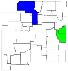
s (CBSAs) that are linked by commuting ties. There are two combined statistical areas in New Mexico.
- Clovis-Portales CSAClovis-Portales combined statistical areaThe Clovis-Portales Combined Statistical Area is made up of two counties in east central New Mexico. The statistical area consists of the Clovis Micropolitan Statistical Area and the Portales Micropolitan Statistical Area...
- Clovis Micropolitan Statistical AreaClovis, New MexicoClovis is the county seat of Curry County, New Mexico, United States. Its population was 32,667 at the 2000 census; according to 2010 Census Bureau estimates, the population had risen to 37,775....
- Curry CountyCurry County, New MexicoCurry County is a county located in the U.S. state of New Mexico. The population was approximately 45,044 at the 2000 census. Its county seat is Clovis. It is named in honor of George Curry, territorial governor of New Mexico from 1907 to 1910...
- Curry County
- Portales Micropolitan Statistical AreaPortales, New MexicoPortales is a city in and the county seat of Roosevelt County, New Mexico, United States. The population was 11,131 at the 2000 census. Portales is located near the larger city of Clovis as well as Cannon Air Force Base, a major contributor to the economy of the region.Eastern New Mexico...
- Roosevelt CountyRoosevelt County, New Mexico-2010:Whereas according to the 2010 U.S. Census Bureau:*76.9% White*1.8% Black*1.3% Native American*0.9% Asian*0.0% Native Hawaiian or Pacific Islander*3.2% Two or more races*15.9% Other races*39.9% Hispanic or Latino -2000:...
- Roosevelt County
- Clovis Micropolitan Statistical Area
- Santa Fe-Espanola CSASanta Fe-Espanola combined statistical areaThe Santa Fe-Española Combined Statistical Area is made up of two counties in north central New Mexico. The statistical area consists of the Santa Fe Metropolitan Statistical Area and the Española Micropolitan Statistical Area...
- Santa Fe Metropolitan Statistical AreaSanta Fe, New MexicoSanta Fe is the capital of the U.S. state of New Mexico. It is the fourth-largest city in the state and is the seat of . Santa Fe had a population of 67,947 in the 2010 census...
- Santa Fe CountySanta Fe County, New Mexico-2010:Whereas according to the 2010 U.S. Census Bureau:*76.2% White*0.9% Black*3.1% Native American*1.2% Asian*0.1% Native Hawaiian or Pacific Islander*3.6% Two or more races*14.9% Other races*50.6% Hispanic or Latino -2000:...
- Santa Fe County
- Espanola Micropolitan Statistical AreaEspañola, New MexicoEspañola also known as Espanola , is a city primarily in Rio Arriba County, New Mexico, in the United States. A portion of the central and eastern section of the city is in Santa Fe County. Española was founded in 1880 as a railroad village, incorporated as a city in 1925. The city is situated in...
- Rio Arriba CountyRio Arriba County, New Mexico-2010:Whereas according to the 2010 U.S. Census Bureau:*51.6% White*0.5% Black*16.0% Native American*0.4% Asian*0.0% Native Hawaiian or Pacific Islander*3.3% Two or more races*28.2% Other races*71.3% Hispanic or Latino -2000:...
- Rio Arriba County
- Santa Fe Metropolitan Statistical Area
Population statistics
| Combined Statistical Area | July 1, 2009 Estimate |
2000 Population |
Percent Change (2000–2009) |
|---|---|---|---|
| Clovis-Portales CSA Clovis-Portales combined statistical area The Clovis-Portales Combined Statistical Area is made up of two counties in east central New Mexico. The statistical area consists of the Clovis Micropolitan Statistical Area and the Portales Micropolitan Statistical Area... |
63,224 | 63,062 | 0.26% |
| Santa Fe-Espanola CSA Santa Fe-Espanola combined statistical area The Santa Fe-Española Combined Statistical Area is made up of two counties in north central New Mexico. The statistical area consists of the Santa Fe Metropolitan Statistical Area and the Española Micropolitan Statistical Area... |
188,210 | 170,482 | 10.40% |
See also
- List of micropolitan areas in New Mexico
- List of cities in New Mexico
- New Mexico census statistical areasNew Mexico census statistical areasThe United States Census Bureau has defined 2 Combined Statistical Areas , 4 Metropolitan Statistical Areas , and 15 Micropolitan Statistical Areas in the State of New Mexico. The following table describes these areas with the following information:*The name of the Combined Statistical Area , if...
- Table of United States primary census statistical areas (PCSA)
- Table of United States Combined Statistical AreasTable of United States Combined Statistical Areasthumb|An enlargeable map of the 125 [[Combined Statistical Area]]s of the [[United States]]The United States Office of Management and Budget has defined 125 Combined Statistical Areas for the United States of America...
(CSA) - Table of United States Metropolitan Statistical AreasTable of United States Metropolitan Statistical Areasthumb|An enlargeable map of the 942 [[Core Based Statistical Area]]s of the [[United States]]. The 367 [[Metropolitan Statistical Area]]s are shown in red....
(MSA) - Table of United States Micropolitan Statistical AreasTable of United States Micropolitan Statistical Areasthumb|An enlargeable map of the 942 [[Core Based Statistical Area]]s of the [[United States]]. The 576 [[Micropolitan Statistical Area]]s are shown in blue....
(μSA)

