List of quadrangles on Mars
Encyclopedia
The surface of Mars
has been divided into 30 quadrangle
s by the United States Geological Survey
, so named because their borders lie along lines of latitude and longitude and so maps appear rectangular. Martian quadrangles are named after local features and are numbered with the prefix "MC" for "Mars Chart."
West longitude is used.

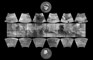
Relationship of quadrangles to each other:
Mars
Mars is the fourth planet from the Sun in the Solar System. The planet is named after the Roman god of war, Mars. It is often described as the "Red Planet", as the iron oxide prevalent on its surface gives it a reddish appearance...
has been divided into 30 quadrangle
Quadrangle (geography)
In geology or geography, the word "quadrangle" usually refers to a United States Geological Survey 7.5-minute quadrangle map, which are usually named after a local physiographic feature. The shorthand "quad" is also used, especially with the name of the map; for example, "the Ranger Creek, Texas...
s by the United States Geological Survey
United States Geological Survey
The United States Geological Survey is a scientific agency of the United States government. The scientists of the USGS study the landscape of the United States, its natural resources, and the natural hazards that threaten it. The organization has four major science disciplines, concerning biology,...
, so named because their borders lie along lines of latitude and longitude and so maps appear rectangular. Martian quadrangles are named after local features and are numbered with the prefix "MC" for "Mars Chart."
West longitude is used.

| Name | Number | Area |
|---|---|---|
| Mare Boreum Mare Boreum quadrangle The Mare Boreum quadrangle is one of a series of 30 quadrangle maps of Mars used by the United States Geological Survey Astrogeology Research Program. The Mare Boreum quadrangle is also referred to as MC-1 .... (North Pole) |
MC-01 | Latitude 65° to 90°, Longitude 0° to 360° |
| Diacria Diacria quadrangle The Diacria quadrangle is one of a series of 30 quadrangle maps of Mars used by the United States Geological Survey Astrogeology Research Program. The quadrangle is located in the northwestern portion of Mars’ western hemisphere and covers 180° to 240° east longitude and 30° to 65° north latitude... |
MC-02 | Latitude 30° to 65°, Longitude 120° to 180° |
| Arcadia Arcadia quadrangle The Arcadia quadrangle is one of a series of 30 quadrangle maps of Mars used by the United States Geological Survey Astrogeology Research Program. The quadrangle is located in the north-central portion of Mars’ western hemisphere and covers 240° to 300° east longitude and 30° to 65° north latitude... |
MC-03 | Latitude 30° to 65°, Longitude 60° to 120° |
| Mare Acidalium Mare Acidalium quadrangle The Mare Acidalium quadrangle is one of a series of 30 quadrangle maps of Mars used by the United States Geological Survey Astrogeology Research Program. The quadrangle is located in the northeastern portion of Mars’ western hemisphere and covers 300° to 360° east longitude and 30° to 65° north... |
MC-04 | Latitude 30° to 65°, Longitude 0° to 60° |
| Ismenius Lacus Ismenius Lacus quadrangle The Ismenius Lacus quadrangle is one of a series of 30 quadrangle maps of Mars used by the United States Geological Survey Astrogeology Research Program. The quadrangle is located in the northwestern portion of Mars’ eastern hemisphere and covers 0° to 60° east longitude and 30° to 65° north... |
MC-05 | Latitude 30° to 65°, Longitude 300° to 360° |
| Casius Casius quadrangle The Casius quadrangle is one of a series of 30 quadrangle maps of Mars used by the United States Geological Survey Astrogeology Research Program. The quadrangle is located in the north central portion of Mars’ eastern hemisphere and covers 60° to 120° east longitude and 30° to 65° north latitude... |
MC-06 | Latitude 30° to 65°, Longitude 240° to 300° |
| Cebrenia Cebrenia quadrangle The Cebrenia quadrangle is one of a series of 30 quadrangle maps of Mars used by the United States Geological Survey Astrogeology Research Program. The quadrangle is located in the northeastern portion of Mars’ eastern hemisphere and covers 120° to 180° east longitude and 30° to 65° north latitude... |
MC-07 | Latitude 30° to 65°, Longitude 180° to 240° |
| Amazonis Amazonis quadrangle The Amazonis quadrangle is one of a series of 30 quadrangle maps of Mars used by the United States Geological Survey Astrogeology Research Program. The Amazonis quadrangle is also referred to as MC-8 .... |
MC-08 | Latitude 0° to 30°, Longitude 135° to 180° |
| Tharsis Tharsis quadrangle The Tharsis quadrangle is one of a series of 30 quadrangle maps of Mars used by the United States Geological Survey Astrogeology Research Program. The Tharsis quadrangle is also referred to as MC-9 .... |
MC-09 | Latitude 0° to 30°, Longitude 90° to 135° |
| Lunae Palus Lunae Palus quadrangle The Lunae Palus quadrangle is one of a series of 30 quadrangle maps of Mars used by the United States Geological Survey Astrogeology Research Program. The quadrangle is also referred to as MC-10 .... |
MC-10 | Latitude 0° to 30°, Longitude 45° to 90° |
| Oxia Palus Oxia Palus quadrangle The Oxia Palus quadrangle is one of a series of 30 quadrangle maps of Mars used by the United States Geological Survey Astrogeology Research Program. The Oxia Palus quadrangle is also referred to as MC-11 .... |
MC-11 | Latitude 0° to 30°, Longitude 0° to 45° |
| Arabia Arabia quadrangle The Arabia quadrangle is one of a series of 30 quadrangle maps of Mars used by the United States Geological Survey Astrogeology Research Program. The Arabia quadrangle is also referred to as MC-12 .... |
MC-12 | Latitude 0° to 30°, Longitude 315° to 360° |
| Syrtis Major Syrtis Major quadrangle The Syrtis Major quadrangle is one of a series of 30 quadrangle maps of Mars used by the United States Geological Survey Astrogeology Research Program... |
MC-13 | Latitude 0° to 30°, Longitude 270° to 315° |
| Amenthes Amenthes quadrangle The Amenthes quadrangle is one of a series of 30 quadrangle maps of Mars used by the United States Geological Survey Astrogeology Research Program. The Amenthes quadrangle is also referred to as MC-14 . This quadrangle contains the Isidis basin, a location where magnesium carbonate was found by... |
MC-14 | Latitude 0° to 30°, Longitude 225° to 270° |
| Elysium Elysium quadrangle The Elysium quadrangle is one of a series of 30 quadrangle maps of Mars used by the United States Geological Survey Astrogeology Research Program... |
MC-15 | Latitude 0° to 30°, Longitude 180° to 225° |
| Memnonia | MC-16 | Latitude -30° to 0°, Longitude 135° to 180° |
| Phoenicis Lacus Phoenicis Lacus quadrangle The Phoenicis Lacus quadrangle is one of a series of 30 quadrangle maps of Mars used by the United States Geological Survey Astrogeology Research Program. The Phoenicis Lacus quadrangle is also referred to as MC-17 .... |
MC-17 | Latitude -30° to 0°, Longitude 90° to 135° |
| Coprates Coprates quadrangle The Coprates quadrangle is one of a series of 30 quadrangle maps of Mars used by the United States Geological Survey Astrogeology Research Program... |
MC-18 | Latitude -30° to 0°, Longitude 45° to 90° |
| Margaritifer Sinus Margaritifer Sinus quadrangle The margaritifer Sinus quadrangle is one of a series of 30 quadrangle maps of Mars used by the United States Geological Survey Astrogeology Research Program. The Margaritifer Sinus quadrangle is also referred to as MC-19 .... |
MC-19 | Latitude -30° to 0°, Longitude 0° to 45° |
| Sinus Sabaeus Sinus Sabaeus quadrangle The Sinus Sabaeus quadrangle is one of a series of 30 quadrangle maps of Mars used by the United States Geological Survey Astrogeology Research Program. It is also referred to as MC-20 .... |
MC-20 | Latitude -30° to 0°, Longitude 315° to 360° |
| Iapygia Iapygia quadrangle The Iapygia quadrangle is one of a series of 30 quadrangle maps of Mars used by the United States Geological Survey Astrogeology Research Program. The Iapygia quadrangle is also referred to as MC-21 .... |
MC-21 | Latitude -30° to 0°, Longitude 270° to 315° |
| Mare Tyrrhenum Mare Tyrrhenum quadrangle The Mare Tyrrhenum quadrangle is one of a series of 30 quadrangle maps of Mars used by the United States Geological Survey Astrogeology Research Program. The Mare Tyrrhenum quadrangle is also referred to as MC-22 .... |
MC-22 | Latitude -30° to 0°, Longitude 225° to 270° |
| Aeolis Aeolis quadrangle The Aeolis quadrangle is one of a series of 30 quadrangle maps of Mars used by the United States Geological Survey Astrogeology Research Program. The Aeolis quadrangle is also referred to as MC-23 .... |
MC-23 | Latitude -30° to 0°, Longitude 180° to 225° |
| Phaethontis Phaethontis quadrangle The Phaethontis quadrangle is one of a series of 30 quadrangle maps of Mars used by the United States Geological Survey Astrogeology Research Program. The Phaethontis quadrangle is also referred to as MC-24 .... |
MC-24 | Latitude -65° to -30°, Longitude 120° to 180° |
| Thaumasia Thaumasia quadrangle The Thaumasia quadrangle is one of a series of 30 quadrangle maps of Mars used by the United States Geological Survey Astrogeology Research Program... |
MC-25 | Latitude -65° to -30°, Longitude 60° to 120° |
| Argyre Argyre quadrangle The Argyre quadrangle is one of a series of 30 quadrangle maps of Mars used by the United States Geological Survey Astrogeology Research Program. The Argyre quadrangle is also referred to as MC-26 .... |
MC-26 | Latitude -65° to -30°, Longitude 0° to 60° |
| Noachis Noachis quadrangle The Noachis quadrangle is one of a series of 30 quadrangle maps of Mars used by the United States Geological Survey Astrogeology Research Program. The Noachis quadrangle is also referred to as MC-27 .... |
MC-27 | Latitude -65° to -30°, Longitude 300° to 360° |
| Hellas Hellas quadrangle The Hellas quadrangle is one of a series of 30 quadrangle maps of Mars used by the United States Geological Survey Astrogeology Research Program. The Hellas quadrangle is also referred to as MC-28 .... |
MC-28 | Latitude -65° to -30°, Longitude 240° to 300° |
| Eridania Eridania quadrangle The Eridania quadrangle is one of a series of 30 quadrangle maps of Mars used by the United States Geological Survey Astrogeology Research Program. The Eridania quadrangle is also referred to as MC-29 .... |
MC-29 | Latitude -65° to -30°, Longitude 180° to 240° |
| Mare Australe Mare Australe quadrangle The Mare Australe quadrangle is one of a series of 30 quadrangle maps of Mars used by the United States Geological Survey Astrogeology Research Program. The Mare Australe quadrangle is also referred to as MC-30 .... (South Pole) |
MC-30 | Latitude -90° to -65°, Longitude 0° to 360° |
Relationship of quadrangles to each other:

