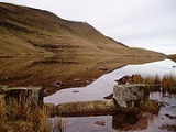
Llyn y Fan Fawr
Encyclopedia
Llyn y Fan Fawr is a natural lake
in the county of Powys
, Wales
. It lies at the foot of Fan Brycheiniog
, the highest peak of the Black Mountain
range within the Brecon Beacons National Park.
The lake is enclosed within a rock hollow formed as a result of glacial action during the ice ages. It is drained by a stream known as Nant y Llyn (Welsh
: 'stream of the lake'), whose waters flow into the River Tawe
. The surface of Llyn y Fan Fawr lies at about 605 m above sea level.
Llyn y Fan Fach
(Welsh
: 'lake of the small peak') which lies 3 km to the west is of similar origin and size but was dammed in the 1930's.
The lake can be reached on foot by a 2 km walk across the moor from the minor Trecastle
to Glyntawe road.
Lake
A lake is a body of relatively still fresh or salt water of considerable size, localized in a basin, that is surrounded by land. Lakes are inland and not part of the ocean and therefore are distinct from lagoons, and are larger and deeper than ponds. Lakes can be contrasted with rivers or streams,...
in the county of Powys
Powys
Powys is a local-government county and preserved county in Wales.-Geography:Powys covers the historic counties of Montgomeryshire and Radnorshire, most of Brecknockshire , and a small part of Denbighshire — an area of 5,179 km², making it the largest county in Wales by land area.It is...
, Wales
Wales
Wales is a country that is part of the United Kingdom and the island of Great Britain, bordered by England to its east and the Atlantic Ocean and Irish Sea to its west. It has a population of three million, and a total area of 20,779 km²...
. It lies at the foot of Fan Brycheiniog
Fan Brycheiniog
Fan Brycheiniog is the highest peak in the Black Mountain region of the Brecon Beacons National Park in South Wales. It is just inside the county of Powys, and also within the Fforest Fawr Geopark designated in 2005 in recognition of the area's geological heritage.The Beacons Way, a waymarked long...
, the highest peak of the Black Mountain
Black Mountain (range)
The Black Mountain is a mountain range in Mid and West Wales, straddling the county boundary between Carmarthenshire and Powys and forming the westernmost range of the Brecon Beacons National Park. Its highest point is Fan Brycheiniog at 802 metres or 2,631 ft. The Black Mountain also forms a part...
range within the Brecon Beacons National Park.
The lake is enclosed within a rock hollow formed as a result of glacial action during the ice ages. It is drained by a stream known as Nant y Llyn (Welsh
Welsh language
Welsh is a member of the Brythonic branch of the Celtic languages spoken natively in Wales, by some along the Welsh border in England, and in Y Wladfa...
: 'stream of the lake'), whose waters flow into the River Tawe
River Tawe
The River Tawe is a river in South Wales. It flows in a principally south-westerly direction for some from its source below Moel Feity in the Old Red Sandstone hills of the western Brecon Beacons to the Bristol Channel at Swansea. Its main tributaries are the right bank Upper and Lower Clydach...
. The surface of Llyn y Fan Fawr lies at about 605 m above sea level.
Llyn y Fan Fach
Llyn y Fan Fach
Llyn y Fan Fach is a dammed lake in the eastern border of the Black Mountain in Carmarthenshire, south Wales. Near to it is found Llyn y Fan Fawr.-Legend of Llyn y Fan Fach:...
(Welsh
Welsh language
Welsh is a member of the Brythonic branch of the Celtic languages spoken natively in Wales, by some along the Welsh border in England, and in Y Wladfa...
: 'lake of the small peak') which lies 3 km to the west is of similar origin and size but was dammed in the 1930's.
The lake can be reached on foot by a 2 km walk across the moor from the minor Trecastle
Trecastle
Trecastle is a village in Powys, Wales, on the edge of the Brecon Beacons National Park.Trecastle is named after an early 12th century motte-and-bailey fortification , built by Bernard de Neufmarche and designed to protect Brecon from attack from the west...
to Glyntawe road.

