
Loddon Valley Highway
Encyclopedia
The Loddon Valley Highway runs roughly north-west from Bendigo
to Kerang
on the Murray Valley Highway
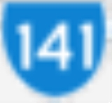
. Previously assigned State Route 141, it was later designated as B260.
After passing through the hills around Bendigo and Eaglehawk
, the highway joins the Loddon River at Serpentine
, then follows along the east side of that river all the way to Kerang.
The Loddon Valley Highway constitutes part of the direct route from Melbourne
to the popular Murray River
holiday areas around Swan Hill
.
Bendigo, Victoria
Bendigo is a major regional city in the state of Victoria, Australia, located very close to the geographical centre of the state and approximately north west of the state capital Melbourne. It is the second largest inland city and fourth most populous city in the state. The estimated urban...
to Kerang
Kerang, Victoria
Kerang is a rural town on the Loddon River in northern Victoria in Australia. It is the commercial centre to an irrigation district based on livestock, horticulture, lucerne and grain. It is located north-west of Melbourne on the Murray Valley Highway a few kilometres north of its intersection...
on the Murray Valley Highway
Murray Valley Highway
The Murray Valley Highway is a popular tourist route, which follows the south side of the Murray River in Victoria, Australia. The route effectively acts as the northern-most highway in Victoria...
. Previously assigned State Route 141, it was later designated as B260.
After passing through the hills around Bendigo and Eaglehawk
Eaglehawk, Victoria
Eaglehawk is a former gold-mining town in Victoria, Australia and a suburb within the City of Greater Bendigo.The town is situated to the north-west of Bendigo on the Loddon Valley Highway. The highway is known locally as High Street until the intersection with Sailors Gully Road and as Peg Leg...
, the highway joins the Loddon River at Serpentine
Serpentine, Victoria
Serpentine is a town in north west Victoria, Australia. Located on the Loddon Valley Highway, the town is 201 kilometres north west of the state capital, Melbourne and 51 kilometres north west of the regional centre, Bendigo...
, then follows along the east side of that river all the way to Kerang.
The Loddon Valley Highway constitutes part of the direct route from Melbourne
Melbourne
Melbourne is the capital and most populous city in the state of Victoria, and the second most populous city in Australia. The Melbourne City Centre is the hub of the greater metropolitan area and the Census statistical division—of which "Melbourne" is the common name. As of June 2009, the greater...
to the popular Murray River
Murray River
The Murray River is Australia's longest river. At in length, the Murray rises in the Australian Alps, draining the western side of Australia's highest mountains and, for most of its length, meanders across Australia's inland plains, forming the border between New South Wales and Victoria as it...
holiday areas around Swan Hill
Swan Hill, Victoria
Swan Hill is a city in the northwest of Victoria, Australia. It is located on the Murray Valley Highway, on the south bank of the Murray River, downstream from the junction of the Loddon River. At the 2006 census, Swan Hill had a population of 9,684.-History:...
.
Major intersections and towns
Loddon Valley Highway  |
|||
| Northbound | Distance to Kerang (km) |
Distance to Melbourne (km) |
Southbound |
| End Loddon Valley Highway continues as Murray Valley Highway Murray Valley Highway The Murray Valley Highway is a popular tourist route, which follows the south side of the Murray River in Victoria, Australia. The route effectively acts as the northern-most highway in Victoria...  to Kerang Kerang, Victoria Kerang is a rural town on the Loddon River in northern Victoria in Australia. It is the commercial centre to an irrigation district based on livestock, horticulture, lucerne and grain. It is located north-west of Melbourne on the Murray Valley Highway a few kilometres north of its intersection... / Swan Hill Swan Hill, Victoria Swan Hill is a city in the northwest of Victoria, Australia. It is located on the Murray Valley Highway, on the south bank of the Murray River, downstream from the junction of the Loddon River. At the 2006 census, Swan Hill had a population of 9,684.-History:... |
3 | 275 | Start Loddon Valley Highway from Murray Valley Highway Murray Valley Highway The Murray Valley Highway is a popular tourist route, which follows the south side of the Murray River in Victoria, Australia. The route effectively acts as the northern-most highway in Victoria... |
| Cohuna Cohuna, Victoria Cohuna is a town situated north of Melbourne, on the Murray Valley Highway, in northern Victoria, Australia. At the 2006 census, Cohuna had a population of 1,893.-History:... , Echuca Echuca, Victoria Echuca is a town located on the banks of the Murray River and Campaspe river in Victoria, Australia. The Border town Moama is on the northern side of the Murray river in New South Wales. It is the administrative centre and largest settlement in the Shire of Campaspe... Murray Valley Highway Murray Valley Highway The Murray Valley Highway is a popular tourist route, which follows the south side of the Murray River in Victoria, Australia. The route effectively acts as the northern-most highway in Victoria... .svg.png) |
|||
| continues as |
44 | 234 | Pyramid Hill Pyramid Hill, Victoria Pyramid Hill is a town in Victoria, Australia located in the Shire of Loddon. It is located north of Melbourne and north of Bendigo. At the 2006 census, Pyramid Hill had a population of 465. The town has its own railway station.... , Cohuna Cohuna, Victoria Cohuna is a town situated north of Melbourne, on the Murray Valley Highway, in northern Victoria, Australia. At the 2006 census, Cohuna had a population of 1,893.-History:... Boort-Pyramid Road |
| Pyramid Hill Pyramid Hill, Victoria Pyramid Hill is a town in Victoria, Australia located in the Shire of Loddon. It is located north of Melbourne and north of Bendigo. At the 2006 census, Pyramid Hill had a population of 465. The town has its own railway station.... , Cohuna Cohuna, Victoria Cohuna is a town situated north of Melbourne, on the Murray Valley Highway, in northern Victoria, Australia. At the 2006 census, Cohuna had a population of 1,893.-History:... Boort-Pyramid Road |
duplexes with |
||
| duplexes with |
46 | 232 | Boort Boort, Victoria Boort is a town in Victoria, Australia, located next to Lake Boort, in the Shire of Loddon. At the 2006 census, Boort had a population of 773. The town is known for its native birdlife... , Wycheproof Wycheproof, Victoria Wycheproof is a small regional locality in the centre of the Shire of Buloke, in north western Victoria, Australia. As of the 2006 census, it had a population of 686... Boort-Pyramid Road |
| Boort Boort, Victoria Boort is a town in Victoria, Australia, located next to Lake Boort, in the Shire of Loddon. At the 2006 census, Boort had a population of 773. The town is known for its native birdlife... , Wycheproof Wycheproof, Victoria Wycheproof is a small regional locality in the centre of the Shire of Buloke, in north western Victoria, Australia. As of the 2006 census, it had a population of 686... Boort-Pyramid Road |
continues as |
||
| Mitiamo Mitiamo, Victoria Mitiamo is a town in northern Victoria, Australia. The town is located in the Shire of Loddon, north of the state capital, Melbourne. At the 2006 census, Mitiamo had a population of 76.... , Echuca Echuca, Victoria Echuca is a town located on the banks of the Murray River and Campaspe river in Victoria, Australia. The Border town Moama is on the northern side of the Murray river in New South Wales. It is the administrative centre and largest settlement in the Shire of Campaspe... Boort-Mitiamo Road |
56 | 222 | Mitiamo Mitiamo, Victoria Mitiamo is a town in northern Victoria, Australia. The town is located in the Shire of Loddon, north of the state capital, Melbourne. At the 2006 census, Mitiamo had a population of 76.... , Echuca Echuca, Victoria Echuca is a town located on the banks of the Murray River and Campaspe river in Victoria, Australia. The Border town Moama is on the northern side of the Murray river in New South Wales. It is the administrative centre and largest settlement in the Shire of Campaspe... Boort-Mitiamo Road |
| Serpentine Serpentine, Victoria Serpentine is a town in north west Victoria, Australia. Located on the Loddon Valley Highway, the town is 201 kilometres north west of the state capital, Melbourne and 51 kilometres north west of the regional centre, Bendigo... |
79 | 199 | Serpentine Serpentine, Victoria Serpentine is a town in north west Victoria, Australia. Located on the Loddon Valley Highway, the town is 201 kilometres north west of the state capital, Melbourne and 51 kilometres north west of the regional centre, Bendigo... |
| Bridgewater On Loddon Bridgewater On Loddon, Victoria Bridgewater On Loddon is a town in north central Victoria, Australia. The town is located on the Calder Highway, north west of Bendigo, astride the Loddon River. At the 2006 census, Bridgewater On Loddon had a population of 391... , Dunolly Dunolly, Victoria Dunolly is a town in Victoria, Australia, located on the Dunolly - Maryborough Road, in the Shire of Central Goldfields. At the 2006 census, Dunolly had a population of 969.... Bridgewater-Serpentine Road |
Bridgewater On Loddon Bridgewater On Loddon, Victoria Bridgewater On Loddon is a town in north central Victoria, Australia. The town is located on the Calder Highway, north west of Bendigo, astride the Loddon River. At the 2006 census, Bridgewater On Loddon had a population of 391... , Dunolly Dunolly, Victoria Dunolly is a town in Victoria, Australia, located on the Dunolly - Maryborough Road, in the Shire of Central Goldfields. At the 2006 census, Dunolly had a population of 969.... Bridgewater-Serpentine Road |
||
SWAN HILL RAIL LINE .svg.png) |
119 | 159 | SWAN HILL RAIL LINE |
| Pyramid Hill Pyramid Hill, Victoria Pyramid Hill is a town in Victoria, Australia located in the Shire of Loddon. It is located north of Melbourne and north of Bendigo. At the 2006 census, Pyramid Hill had a population of 465. The town has its own railway station.... Bendigo-Pyramid Road |
122.5 | 155.5 | Eaglehawk Eaglehawk, Victoria Eaglehawk is a former gold-mining town in Victoria, Australia and a suburb within the City of Greater Bendigo.The town is situated to the north-west of Bendigo on the Loddon Valley Highway. The highway is known locally as High Street until the intersection with Sailors Gully Road and as Peg Leg... |
| Eaglehawk Eaglehawk, Victoria Eaglehawk is a former gold-mining town in Victoria, Australia and a suburb within the City of Greater Bendigo.The town is situated to the north-west of Bendigo on the Loddon Valley Highway. The highway is known locally as High Street until the intersection with Sailors Gully Road and as Peg Leg... |
Pyramid Hill Pyramid Hill, Victoria Pyramid Hill is a town in Victoria, Australia located in the Shire of Loddon. It is located north of Melbourne and north of Bendigo. At the 2006 census, Pyramid Hill had a population of 465. The town has its own railway station.... Bendigo-Pyramid Road |
||
| SWAN HILL RAIL LINE | 123.4 | 154.6 | SWAN HILL RAIL LINE |
| Heathcote Heathcote, Victoria Heathcote is a town in central Victoria, Australia, situated on the Northern Highway 110 kilometres north of Melbourne and 40 kilometres south-east of Bendigo via the McIvor Highway. Heathcote's local government area is the City of Greater Bendigo and it is part of the federal electorate of... Sandhurst Road  |
123.5 | 154.5 | Heathcote Heathcote, Victoria Heathcote is a town in central Victoria, Australia, situated on the Northern Highway 110 kilometres north of Melbourne and 40 kilometres south-east of Bendigo via the McIvor Highway. Heathcote's local government area is the City of Greater Bendigo and it is part of the federal electorate of... , Kilmore Kilmore, Victoria Kilmore is a town in the Australian state of Victoria. Located north of Melbourne, it is contentiously claimed as Victoria's oldest inland settled town... Sandhurst Road |
| White Hills White Hills, Victoria White Hills is a suburb of the City of Bendigo in central Victoria, Australia. At the 2006 census, White Hills had a population of 2,626.White Hills Post Office opened on 21 August 1857 during the gold rush.... , Echuca Echuca, Victoria Echuca is a town located on the banks of the Murray River and Campaspe river in Victoria, Australia. The Border town Moama is on the northern side of the Murray river in New South Wales. It is the administrative centre and largest settlement in the Shire of Campaspe... Holdsworth Road |
125.2 | 152.8 | White Hills White Hills, Victoria White Hills is a suburb of the City of Bendigo in central Victoria, Australia. At the 2006 census, White Hills had a population of 2,626.White Hills Post Office opened on 21 August 1857 during the gold rush.... Holdsworth Road |
| Golden Square Golden Square, Victoria Golden Square is a suburb of Bendigo in Victoria, Australia.-Today:Golden Square is home to The Bulldogs Football and Netball Team competing in the Bendigo Football League... Golden Square-Long Gully Road |
126 | 152 | Golden Square Golden Square, Victoria Golden Square is a suburb of Bendigo in Victoria, Australia.-Today:Golden Square is home to The Bulldogs Football and Netball Team competing in the Bendigo Football League... , Marong Marong, Victoria Marong is a town in Victoria, Australia. At the 2001 census, Marong had a population of 393. It is located kilometres to the west of Bendigo. Its local government area is the City of Greater Bendigo... Golden Square-Long Gully Road |
| Start Loddon Valley Highway from Calder Highway Calder Highway Calder Highway is a Highway linking Ravenswood South in Victoria, to Mildura. North of the Victoria/New South Wales border, the highway continues north to Broken Hill, Tibooburra and the New South Wales/Queensland border as the Silver City Highway, under the standard national route shield as far...  |
127 | 151 | Marong Marong, Victoria Marong is a town in Victoria, Australia. At the 2001 census, Marong had a population of 393. It is located kilometres to the west of Bendigo. Its local government area is the City of Greater Bendigo... , Mildura Mildura, Victoria Mildura is a regional city in northwestern Victoria, Australia and seat of the Rural City of Mildura local government area. It is located in the Sunraysia region, and is on the banks of the Murray River. The current population is estimated at just over 30,000.Mildura is a major agricultural centre... Calder Highway Calder Highway Calder Highway is a Highway linking Ravenswood South in Victoria, to Mildura. North of the Victoria/New South Wales border, the highway continues north to Broken Hill, Tibooburra and the New South Wales/Queensland border as the Silver City Highway, under the standard national route shield as far... |
| End Loddon Valley Highway continues as Calder Highway Calder Highway Calder Highway is a Highway linking Ravenswood South in Victoria, to Mildura. North of the Victoria/New South Wales border, the highway continues north to Broken Hill, Tibooburra and the New South Wales/Queensland border as the Silver City Highway, under the standard national route shield as far... to Bendigo City Centre Bendigo, Victoria Bendigo is a major regional city in the state of Victoria, Australia, located very close to the geographical centre of the state and approximately north west of the state capital Melbourne. It is the second largest inland city and fourth most populous city in the state. The estimated urban... / Melbourne Melbourne Melbourne is the capital and most populous city in the state of Victoria, and the second most populous city in Australia. The Melbourne City Centre is the hub of the greater metropolitan area and the Census statistical division—of which "Melbourne" is the common name. As of June 2009, the greater... |
|||
See also
- Highways in AustraliaHighways in AustraliaThis is a list of highways in Australia, listed alphabetically along with each highway's route number and location. Note that some highways service more than one state or territory.-Route numbering systems:...
- Highways in VictoriaHighways in VictoriaThe Highways in Victoria are the highest density in any state in Australia. Unlike Australia's other mainland states where vast areas are very sparsely inhabited "outback", there are population centres spread out over most of the state, with only the far north-west and the Victorian Alps lacking...