

Longwood, Bronx
Encyclopedia

The Bronx
The Bronx is the northernmost of the five boroughs of New York City. It is also known as Bronx County, the last of the 62 counties of New York State to be incorporated...
, New York City
New York City
New York is the most populous city in the United States and the center of the New York Metropolitan Area, one of the most populous metropolitan areas in the world. New York exerts a significant impact upon global commerce, finance, media, art, fashion, research, technology, education, and...
. The neighborhood is part of Bronx Community Board 2
Bronx Community Board 2
Bronx Community Board 2 is a local government unit of the city of New York, encompassing the neighborhoods of Hunts Point and Longwood in the borough of the Bronx...
. Its boundaries, starting from the north and moving clockwise are: East 167th Street to the north, the Bronx River
Bronx River
The Bronx River, approximately long, flows through southeast New York in the United States. It is named after colonial settler Jonas Bronck. The Bronx River is the only fresh water river in New York City....
& the Bruckner Expressway
Bruckner Expressway
The Bruckner Expressway is a freeway in The Bronx. It carries Interstate 278 and Interstate 95 from the Robert F. Kennedy Bridge to the south end of the New England Thruway at the Pelham Parkway interchange....
to east, East 149th Street to the south, and Prospect Avenue to the west. Southern Blvd is the primary thoroughfare through Longwood. The local subway is the 6 line, operating along Southern Blvd. Zip codes include 10455 and 10459. The neighborhood is served by the NYPD's 41st Precinct. NYCHA property in the area is patrolled by P.S.A. 7 at 737 Melrose Avenue in the Melrose
Melrose, Bronx
Melrose is primarily a residential neighborhood geographically located in the SouthWestern section of the borough of The Bronx in New York City. The neighborhood is part of Bronx Community Board 1. Its boundaries, starting from the North and moving clockwise are: East 161st Street to the North,...
section of the Bronx.
Demographics
Longwood has a population over 35,000 people. For decades Longwood has been one of the poorest communities in America. Over half the population lives below the poverty line and receives public assistance (AFDC, Home Relief, Supplemental Security Income, and Medicaid). Longwood has one of the highest concentrations of Puerto Ricans in all of New York City. The vast majority of households are renter occupied.Land use and terrain
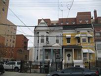
Longwood is dominated by tenement buildings, older multi-unit homes, vacant lots, and newly constructed attached multi-unit subsidized townhouses and apartment buildings. Most of the original housing stock was structurally damaged by arson and eventually razed by the city. The total land area is roughly half a square mile. The terrain is somewhat hilly.Longwood Historic District
The landmarked Longwood Historic DistrictLongwood Historic District (Bronx)
The Longwood Historic District is a nationally recognized historic district located in the center of the Longwood neighborhood in the South Bronx, New York...
is located in the southern part of the neighborhood. It consists of about three square blocks including buildings on Beck, Kelly, Dawson and Hewitt Place. The district largely consists of rowhouses, most of which were designed by one architect, Warren C. Dickerson.
Low income public housing projects
There are four NYCHA developments located in Longwood.- West Farms Square Rehab; four rehabilitated tenement buildings, 6-stories tall.
- East 165th Street-Bryant Avenue; five buildings, 3-stories tall.
- Longfellow Avenue Rehab; two, 5-story rehabilitated tenement buildings.
- Stebbins Avenue-Hewitt Place; two, 3-story buildings.
History

White flight
White flight has been a term that originated in the United States, starting in the mid-20th century, and applied to the large-scale migration of whites of various European ancestries from racially mixed urban regions to more racially homogeneous suburban or exurban regions. It was first seen as...
and abandonment began. By the late 1960s, many buildings in the neighborhood had burned down in an epidemic of arson. In the 1960s, crime reached such a level that the 41st Precinct Station House at 1086 Simpson Street became known by the police as "Fort Apache, the Bronx", as was later immortalized in a 1981 movie
Fort Apache, The Bronx
Fort Apache, The Bronx is a 1981 crime drama film made by Producers Circle, Time-Life Television Productions Inc., and distributed by Twentieth Century-Fox Film Corporation. It was directed by Daniel Petrie and produced by Martin Richards, Thomas Fiorello, with David Susskind as executive producer...
named for it.
The wave of arson ended when community groups such as Banana Kelly and SEBCO began to protect the remaining tenement buildings. Federal funding for new multi-family homes began in 1986 under the Ed Koch
Ed Koch
Edward Irving "Ed" Koch is an American lawyer, politician, and political commentator. He served in the United States House of Representatives from 1969 to 1977 and three terms as mayor of New York City from 1978 to 1989...
administration.
During the mid-1990s, local and federal governments invested over $550 million in new subsidized residential housing and the expansion of businesses and commerce. With the building of the new South Bronx headquarters of P.A.L.; the relocation of the 41st Precinct of the NYPD from Simpson Street to Longwood Avenue; the Banana Kelly High School; and several small and large businesses (such as Rite Aid
Rite Aid
Rite Aid is a drugstore chain in the United States and a Fortune 500 company headquartered in East Pennsboro Township, Pennsylvania, near Camp Hill. Rite Aid is the largest drugstore chain on the East Coast and the third largest drugstore chain in the U.S....
and McDonald's
McDonald's
McDonald's Corporation is the world's largest chain of hamburger fast food restaurants, serving around 64 million customers daily in 119 countries. Headquartered in the United States, the company began in 1940 as a barbecue restaurant operated by the eponymous Richard and Maurice McDonald; in 1948...
). Thanks in part to the new 41st Precinct on Longwood Avenue and Southern Blvd and public and private investment in the community.
Despite the new housing, there are still remains of the old Jewish presence in Longwood. For instance, 830 Fox Street, which is now a newly constructed low income apartment building, was formerly a Jewish synagogue
Synagogue
A synagogue is a Jewish house of prayer. This use of the Greek term synagogue originates in the Septuagint where it sometimes translates the Hebrew word for assembly, kahal...
that burned down in the 1960s. It was abandoned for many decades, until 2006 when they began construction. In the 1950s the Puerto Rican community began to emerge. Now it is filled with large population of minorities and is an extremely poor community, but has progressed from 1980s-90s.
Schools
- PS 333: The Museum School (East 163rd Street and Rev. James A. Polite Avenue)
- PS 335: The Academy of the Arts (East 163rd Street and Rev. James A. Polite Avenue)
- PS 62: Inocencio Casanova (Leggett Avenue and Fox Street)
- PS 130: Abram Stevens Hewitt (East 156th Street and Prospect Avenue)
- PS 150: Charles James Fox (East 167th Street and Fox Street)
- MS 302: Luisa Dessus Cruz (Kelly Street and Avenue St. John)
- Bronx Regional High School (East 165th Street and Rev. James A. Polite Avenue)
- South Bronx Classical Charter SchoolSouth Bronx Classical Charter SchoolSouth Bronx Classical Charter School is a charter school in the Bronx borough of New York City. It was founded in September 2004 by Lester Long, a former investment banker and elementary school teacher.- Early history :...
(Westchester Avenue and Fox Street)
Transportation
- Bx4: to Westchester Square–East Tremont Avenue (via Westchester Avenue)
- Bx5: to Pelham Bay ParkPelham Bay ParkPelham Bay Park, located in the northeast corner of the New York City borough of The Bronx and extending partially into Westchester County, is at the largest public park in New York City. The section of the park within New York City's borders is more than three times the size of Manhattan's...
(via Story Avenue) - Bx6: to Hunt's PointHunts Point, BronxHunts Point is a low-income neighborhood located on a peninsula in the South Bronx in New York City. It is the location of one of the largest food distribution facilities in the world. The neighborhood is part of Bronx Community Board 2. Its boundaries are the Bruckner Expressway to the west and...
or Riverside Drive-158th Street, ManhattanRiverside Drive (Manhattan)Riverside Drive is a scenic north-south thoroughfare in the Manhattan borough of New York City. The boulevard runs on the west side of Manhattan, generally parallel to the Hudson River from 72nd Street to near the George Washington Bridge at 181st Street...
(via 161st–163rd Streets) - Bx11: to George Washington Bridge Bus TerminalGeorge Washington Bridge Bus TerminalThe George Washington Bridge Bus Station is a commuter bus terminal located at the east end of the George Washington Bridge in the Washington Heights area of Manhattan in New York City, New York....
(via 170th St–Claremont Pkwy) - Bx17: to Fordham Plaza or Port MorrisPort Morris, BronxPort Morris is a neighborhood in the southwest Bronx, New York City. It is a heavily industrial neighborhood. Its boundaries are the Major Deegan Expressway and Bruckner Expressway to the north, East 149th Street to the east, the East River to the southeast, the Bronx Kill south, and the Harlem...
(via Prospect–Crotona Avenues) - Bx19: to New York Botanical Gardens or Riverbank State ParkRiverbank State ParkRiverbank State Park is a park built on the top of a sewage treatment facility on the Hudson River, in the New York City borough of Manhattan....
(via 149th Street–Southern Boulevard) - Bx27: to Clason PointClason Point, BronxClason Point is a peninsula geographically located in the south central Bronx. The area includes a collection of neighborhoods including: Bronx River, Harding Park, Soundview-Bruckner, and Soundview. The neighborhoods are part of Bronx Community Board 9...
(via Rosedale Avenue) - Bx35: to George Washington Bridge Bus TerminalGeorge Washington Bridge Bus TerminalThe George Washington Bridge Bus Station is a commuter bus terminal located at the east end of the George Washington Bridge in the Washington Heights area of Manhattan in New York City, New York....
(via 167th Street) - Whitlock Avenue (IRT Pelham Line)Whitlock Avenue (IRT Pelham Line)Whitlock Avenue is a local station on the IRT Pelham Line of the New York City Subway. It is served by the 6 train at all times and is located at Whitlock Avenue and Westchester Avenue in the Bronx....
- Simpson Street (IRT White Plains Road Line)Simpson Street (IRT White Plains Road Line)Simpson Street is a local station on the IRT White Plains Road Line of the New York City Subway. Located at the intersection of Simpson Street and Westchester Avenue in the Bronx, it is served by the 2 train at all times, and the 5 train at all times except late nights and rush hours in the peak...
- Intervale Avenue (IRT White Plains Road Line)Intervale Avenue (IRT White Plains Road Line)Intervale Avenue is a local station on the IRT White Plains Road Line of the New York City Subway...
- Hunts Point Avenue (IRT Pelham Line)Hunts Point Avenue (IRT Pelham Line)Hunts Point Avenue is an express station on the IRT Pelham Line of the New York City Subway. It has three tracks and two island platforms; served by the 6 train at all times and the <6> train on weekdays in the peak direction...
- Prospect Avenue (IRT White Plains Road Line)Prospect Avenue (IRT White Plains Road Line)Prospect Avenue is a local station on the IRT White Plains Road Line of the New York City Subway. Located at the intersection of Prospect and Westchester Avenues in the Bronx, it is served by the 2 train at all times, and by the 5 train at all times except late nights and rush hours in peak...
- Longwood Avenue (IRT Pelham Line)Longwood Avenue (IRT Pelham Line)Longwood Avenue is a local station on the IRT Pelham Line of the New York City Subway. It is served by the 6 train at all times and is located at Longwood Avenue and Southern Boulevard in the Bronx....
- East 149th Street (IRT Pelham Line)East 149th Street (IRT Pelham Line)East 149th Street is a local station on the IRT Pelham Line of the New York City Subway. It is served by the 6 train at all times and is located at the intersection of East 149th Street, Prospect Avenue, and Southern Boulevard in the Bronx....
Facts
- In 1985 an empty lot of land along Kelly Street and Intervale Avenue became Bill Rainey Park.
- Several crimes struck chords in this community. On February 14, 1993, someone shot several people in the "St. Valentine's Day Massacre." In the spring of 2007, a police officer shot and killed the unarmed Fermin Arzu on the corner of Hewitt Place and Longwood Avenue.
- Colin PowellColin PowellColin Luther Powell is an American statesman and a retired four-star general in the United States Army. He was the 65th United States Secretary of State, serving under President George W. Bush from 2001 to 2005. He was the first African American to serve in that position. During his military...
grew up on Kelly Street in Longwood. - The Bronx Detective Bureau division of the NYPD operates out of the old 41st Precinct house "Fort Apache" at Simpson and East 167th Street.
- Congressman José Enrique Serrano holds his district's headquarters across the street from the 41st Precinct in Longwood.
- On December 31, 2007 Mayor Bloomberg signed the Southern Boulevard B.I.D. (Business Improvement District) into law thus making the HPEDC effort a success story in the improvement of the neighborhood, as well as the entire South Bronx.
- Longwood is considered part of the socioeconomic South BronxSouth BronxThe South Bronx is an area of the New York City borough of The Bronx. The neighborhoods of Tremont, University Heights, Highbridge, Morrisania, Soundview, Hunts Point, and Castle Hill are sometimes considered part of the South Bronx....
.