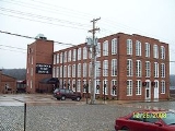
Lower Basin Historic District
Encyclopedia
The Lower Basin Historic District is a national historic district
located in Lynchburg, Virginia
. The district defines a commercial and industrial warehouse area located between the downtown commercial area to the south and the James River
waterfront to the north. The district contains a variety of mostly late 19th- and early 20th-century, multi-story, brick warehouses and factories, two-to-three-story brick
commercial buildings, and a number of structures associated with the James River and Kanawha Canal
and the Norfolk and Western and Chesapeake and Ohio Railways. The district is named for a wide basin of the canal that once extended between Ninth Street and Horseford Road, and contains 60 contributing buildings, two contributing structures (a viaduct and a stone bridge), and one contributing object-a monument commemorating
the site of 18th-century Lynch's Ferry.
It was listed on the National Register of Historic Places
in 1987 and the boundary increased in 2002.
Historic district (United States)
In the United States, a historic district is a group of buildings, properties, or sites that have been designated by one of several entities on different levels as historically or architecturally significant. Buildings, structures, objects and sites within a historic district are normally divided...
located in Lynchburg, Virginia
Lynchburg, Virginia
Lynchburg is an independent city in the Commonwealth of Virginia. The population was 75,568 as of 2010. Located in the foothills of the Blue Ridge Mountains along the banks of the James River, Lynchburg is known as the "City of Seven Hills" or "The Hill City." Lynchburg was the only major city in...
. The district defines a commercial and industrial warehouse area located between the downtown commercial area to the south and the James River
James River (Virginia)
The James River is a river in the U.S. state of Virginia. It is long, extending to if one includes the Jackson River, the longer of its two source tributaries. The James River drains a catchment comprising . The watershed includes about 4% open water and an area with a population of 2.5 million...
waterfront to the north. The district contains a variety of mostly late 19th- and early 20th-century, multi-story, brick warehouses and factories, two-to-three-story brick
commercial buildings, and a number of structures associated with the James River and Kanawha Canal
James River and Kanawha Canal
The James River and Kanawha Canal was a canal in Virginia, which was built to facilitate shipments of passengers and freight by water between the western counties of Virginia and the coast....
and the Norfolk and Western and Chesapeake and Ohio Railways. The district is named for a wide basin of the canal that once extended between Ninth Street and Horseford Road, and contains 60 contributing buildings, two contributing structures (a viaduct and a stone bridge), and one contributing object-a monument commemorating
the site of 18th-century Lynch's Ferry.
It was listed on the National Register of Historic Places
National Register of Historic Places
The National Register of Historic Places is the United States government's official list of districts, sites, buildings, structures, and objects deemed worthy of preservation...
in 1987 and the boundary increased in 2002.

