
Lunar Orbiter program
Encyclopedia
.jpg)
Moon
The Moon is Earth's only known natural satellite,There are a number of near-Earth asteroids including 3753 Cruithne that are co-orbital with Earth: their orbits bring them close to Earth for periods of time but then alter in the long term . These are quasi-satellites and not true moons. For more...
orbiter missions launched by the United States
United States
The United States of America is a federal constitutional republic comprising fifty states and a federal district...
from 1966 through 1967. Intended to help select Apollo landing sites by mapping the Moon's surface, they provided the first photographs from lunar orbit.
All five missions were successful, and 99% of the Moon was mapped from photographs taken with a resolution of 60 meters or better. The first three missions were dedicated to imaging 20 potential manned lunar landing sites, selected based on Earth-based observations. These were flown at low inclination orbits. The fourth and fifth missions were devoted to broader scientific objectives and were flown in high-altitude polar orbits. Lunar Orbiter 4 photographed the entire nearside and 9% of the far side, and Lunar Orbiter 5 completed the far side coverage and acquired medium (20 m) and high (2 m) resolution images of 36 pre-selected areas. All Lunar Orbiter craft were launched by an Atlas-Agena
Atlas-Agena
The Atlas-Agena was an American expendable launch system derived from the SM-65 Atlas missile. It was a member of the Atlas family of rockets, and was used for 119 orbital launches between 1960 and 1978....
D launch vehicle.
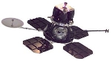
The Lunar Orbiters had an ingenious imaging system, which consisted of a dual-lens camera
Camera
A camera is a device that records and stores images. These images may be still photographs or moving images such as videos or movies. The term camera comes from the camera obscura , an early mechanism for projecting images...
, a film processing unit, a readout scanner, and a film handling apparatus. Both lenses, a 610 mm narrow angle high resolution (HR) lens and an 80 mm wide angle medium resolution (MR) lens, placed their frame exposures on a single roll of 70 mm film
70 mm film
70mm film is a wide high-resolution film gauge, with higher resolution than standard 35mm motion picture film format. As used in camera, the film is wide. For projection, the original 65mm film is printed on film. The additional 5mm are for magnetic strips holding four of the six tracks of sound...
. The axes of the two cameras were coincident so the area imaged in the HR frames were centered within the MR frame areas. The film was moved during exposure to compensate for the spacecraft velocity, which was estimated by an electro-optical sensor. The film was then processed, scanned, and the images transmitted back to Earth.
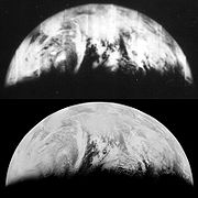
During the Lunar Orbiter missions, the first pictures of Earth as a whole were taken, beginning with Earth-rise over the lunar surface by Lunar Orbiter 1 in August, 1966. The first full picture of the whole Earth was taken by Lunar Orbiter 5 in August, 1967. See http://www.aiga.org/content.cfm/symbolizing-the-green-movement. The second photo of the whole Earth was taken by Lunar Orbiter V on November 10, 1967. This photo was published by Stewart Brand in the first Whole Earth Catalog in the fall of 1968. See http://sciencetrack.blogspot.com/2007/07/first-photo-of-whole-earth.html and http://www.aiga.org/content.cfm/symbolizing-the-green-movement
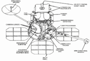
Spacecraft and subsystems
Canopus
Canopus |Alpha]] Carinae) is the brightest star in the southern constellation of Carina and Argo Navis, and the second brightest star in the night-time sky, after Sirius. Canopus's visual magnitude is −0.72, and it has an absolute magnitude of −5.53.Canopus is a supergiant of spectral...
star tracker, command decoder, multiplex encoder, traveling wave tube amplifier (TWTA), and the photographic system. Four solar panels were mounted to extend out from this deck with a total span across of 3.72 m. Also extending out from the base of the spacecraft were a high gain antenna on a 1.32 m boom and a low gain antenna on a 2.08 m boom. Above the equipment deck, the middle deck held the velocity control engine, propellant, oxidizer and pressurization tanks, Sun sensors, and micro-meteoroid detectors. The third deck consisted of a heat shield to protect the spacecraft from the firing of the velocity control engine. The nozzle of the engine protruded through the center of the shield. Mounted on the perimeter of the top deck were four attitude control
Attitude control system
In spaceflight, the attitude control system or attitude determination and control system of a spacecraft consists of equipment to measure, report and change the orientation of the vehicle.- Components :...
thrusters.
Power of 375 W was provided by the four solar arrays containing 10,856 n/p solar cells which would directly run the spacecraft and also charge the 12 A·h nickel-cadmium battery. The batteries were used during brief periods of occultation when no solar power was available. Propulsion for major maneuvers was provided by the gimballed velocity control engine, a hypergolic 100 pound-force (445 N) thrust Marquardt
Marquardt
Marquardt Corporation was one of the few aeronautical engineering firms that was dedicated almost solely to the development of the ramjet engine. Marquardt designs were developed through the 1940s into the 1960s, but the ramjet never became a major design and the company turned to other fields in...
rocket motor. Three axis stabilization and attitude control were provided by four one lbf (4 N) nitrogen gas jets. Navigational knowledge was provided by five Sun sensors, Canopus star sensor, and the IRU equipped with internal gyros. Communications were via a 10 W transmitter and the directional 1 m diameter high gain antenna for transmission of photographs and a 0.5 W transmitter and omnidirectional low gain antenna for other communications. Both antennas operated in S-band at 2295 MHz. Thermal control was maintained by a multilayer aluminized Mylar and Dacron thermal blanket which enshrouded the main bus, special paint, insulation, and small heaters.
The photographic system was provided by Eastman Kodak
Eastman Kodak
Eastman Kodak Company is a multinational imaging and photographic equipment, materials and services company headquarted in Rochester, New York, United States. It was founded by George Eastman in 1892....
and derived from a system designed for the U-2
Lockheed U-2
The Lockheed U-2, nicknamed "Dragon Lady", is a single-engine, very high-altitude reconnaissance aircraft operated by the United States Air Force and previously flown by the Central Intelligence Agency . It provides day and night, very high-altitude , all-weather intelligence gathering...
and SR-71 reconnaissance aircraft. The camera used two lenses to simultaneously expose a wide-angle and a high-resolution image on the same film. The wide-angle, medium resolution mode used a 80 mm F 2.8 Xenotar lens manufactured by Schneider Kreuznach
Schneider Kreuznach
Schneider Kreuznach is the abbreviated name of the company Jos. Schneider Optische Werke GmbH, which is sometimes also simply referred to as Schneider. They are a manufacturer of industrial and photographic optics....
, Germany. The high-resolution mode used a 610 mm F 5.6 Panoramic lens manufactured by the Pacific Optical Company. The film was developed on-orbit, and then scanned by a photomultiplier for transmission to Earth.
Results
The Lunar Orbiter program consisted of five spacecraft which returned photography of 99 percent of the surface of the Moon (near and far side) with resolution down to 1 meter. Altogether the Orbiters returned 2180 high resolution and 882 medium resolution frames. The micro-meteoroid experiments recorded 22 impacts showing the average micro-meteoroid flux near the Moon was about two orders of magnitude greater than in interplanetary space, but slightly less than the near-Earth environment. The radiation experiments confirmed that the design of Apollo hardware would protect the astronauts from average and greater than average short term exposure to solar particle events. The use of Lunar Orbiters for tracking to evaluate the Manned Space Flight NetworkManned Space Flight Network
The Manned Space Flight Network was a set of tracking stations built to support the American space efforts of Mercury, Gemini, Apollo and Skylab...
tracking stations and Apollo Orbit Determination Program was successful, with three Lunar Orbiters (2, 3, and 5) being tracked simultaneously from August to October 1967. The Lunar Orbiters were all eventually commanded to crash on the Moon before their attitude control fuel ran out so they would not present navigational or communications hazards to later Apollo flights. The Lunar Orbiter program was managed by NASA Langley Research Center
Langley Research Center
Langley Research Center is the oldest of NASA's field centers, located in Hampton, Virginia, United States. It directly borders Poquoson, Virginia and Langley Air Force Base...
at a total cost of roughly $200 million.
.jpg)
- Lunar Orbiter 1Lunar Orbiter 1The Lunar Orbiter 1 robotic spacecraft, part of the Lunar Orbiter Program, was designed primarily to photograph smooth areas of the lunar surface for selection and verification of safe landing sites for the Surveyor and Apollo missions...
- Launched August 10, 1966
- Imaged Moon: August 18 to 29, 1966
- Impact with Moon: October 29, 1966
- Apollo landing site survey mission
- Lunar Orbiter 2Lunar Orbiter 2The Lunar Orbiter 2 spacecraft was designed primarily to photograph smooth areas of the lunar surface for selection and verification of safe landing sites for the Surveyor and Apollo missions...
- Launched November 6, 1966
- Imaged Moon: November 18 to 25, 1966
- Impact with Moon: October 11, 1967
- Apollo landing site survey mission
- Lunar Orbiter 3Lunar Orbiter 3The Lunar Orbiter 3 was a spacecraft launched by NASA in 1967, designed primarily to photograph areas of the lunar surface for confirmation of safe landing sites for the Surveyor and Apollo missions...
- Launched February 5, 1967
- Imaged Moon: February 15 to 23, 1967
- Impact with Moon: October 9, 1967
- Apollo landing site survey mission
- Lunar Orbiter 4Lunar Orbiter 4Lunar Orbiter 4 was designed to take advantage of the fact that the three previous Lunar Orbiters had completed the required needs for Apollo mapping and site selection...
- Launched May 4, 1967
- Imaged Moon: May 11 to 26, 1967
- Impact with Moon: Approximately October 31, 1967
- Lunar mapping mission
- Lunar Orbiter 5Lunar Orbiter 5Lunar Orbiter 5, the last of the Lunar Orbiter series, was designed to take additional Apollo and Surveyor landing site photography and to take broad survey images of unphotographed parts of the Moon's far side...
- Launched August 1, 1967
- Imaged Moon: August 6 to 18, 1967
- Impact with Moon: January 31, 1968
- Lunar mapping and hi-res survey mission
Data availability
The Lunar Orbiter orbital photographs were transmitted to Earth as analog data after onboard scanning of the original film into a series of strips. The data were written to magnetic tape and also to film. The film data were used to create hand-made mosaics of Lunar Orbiter frames. Each LO exposure resulted in two photographs: medium-resolution frames recorded by the 80-mm focal-length lens and high-resolution frames recorded by the 610-mm focal length lens. Due to their large size, HR frames were divided into three sections, or sub-frames. Large-format prints (16 x 20 inches) from the mosaics were created and several copies were distributed across the U.S. to NASA image and data libraries known as Regional Planetary Information Facilities. The resulting outstanding views were of generally very high spatial resolution and covered a substantial portion of the lunar surface, but they suffered from a “venetian blind” striping, missing or duplicated data, and frequent saturation effects that hampered their use. Nevertheless, for many years these images have been the basis of much of lunar scientific research. Because they were obtained at low to moderate Sun angles, the Lunar Orbiter photographic mosaics are particularly useful for studying the morphology of lunar topographic features.Several atlases and books featuring Lunar Orbiter photographs have been published. Perhaps the most definitive was that of Bowker and Hughes (1971); it contained 675 photographic plates with approximately global coverage of the Moon. In part because of high interest in the data and in part because that atlas is out of print, the task was undertaken at the Lunar and Planetary Institute to scan the large-format prints of Lunar Orbiter data. These were made available online as the Digital Lunar Orbiter Photographic Atlas of the Moon.
Data recovery and digitization
Astrogeology Research Program
The USGS Astrogeology Science Center has a rich history of participation in space exploration efforts and planetary mapping, starting in 1963 when the Flagstaff Science Center was established by Gene Shoemaker to provide lunar geologic mapping and assist in training astronauts destined for the...
of the US Geological Survey in Flagstaff, AZ was funded by NASA (as part of the Lunar Orbiter Digitization Project) to scan at 25 micrometre resolution archival LO positive film strips that were produced from the original data. The goal was to produce a global mosaic of the Moon using the best available Lunar Orbiter frames (largely the same coverage as that of Bowker and Hughes, 1971). The frames were constructed from scanned film strips; they were digitally constructed, geometrically controlled, and map-projected without the stripes that had been noticeable in the original photographic frames. Because of its emphasis on construction of a global mosaic, this project only scanned about 15% of the available Lunar Orbiter photographic frames. Data from Lunar Orbiter missions III
Lunar Orbiter 3
The Lunar Orbiter 3 was a spacecraft launched by NASA in 1967, designed primarily to photograph areas of the lunar surface for confirmation of safe landing sites for the Surveyor and Apollo missions...
, IV
Lunar Orbiter 4
Lunar Orbiter 4 was designed to take advantage of the fact that the three previous Lunar Orbiters had completed the required needs for Apollo mapping and site selection...
and V
Lunar Orbiter 5
Lunar Orbiter 5, the last of the Lunar Orbiter series, was designed to take additional Apollo and Surveyor landing site photography and to take broad survey images of unphotographed parts of the Moon's far side...
were included in the global mosaic.
In addition, the USGS digitization project created frames from very high resolution Lunar Orbiter images for several 'sites of scientific interest.' These sites had been identified in the 1960s when the Apollo landing sites were being selected. Frames for sites such as the Apollo 12
Apollo 12
Apollo 12 was the sixth manned flight in the American Apollo program and the second to land on the Moon . It was launched on November 14, 1969 from the Kennedy Space Center, Florida, four months after Apollo 11. Mission commander Charles "Pete" Conrad and Lunar Module Pilot Alan L...
landing site, the Marius
Marius (crater)
Marius is a lunar crater located on the Oceanus Procellarum. The surface to the west and north of this crater contains a large number of lunar domes spread across an area over a hundred kilometers in diameter that may be of volcanic origin dubbed the Marius Hills...
Hills, and the Sulpicius Gallus rille have been released.
In 2007, the Lunar Orbiter Image Recovery Project
Lunar Orbiter Image Recovery Project
The Lunar Orbiter Image Recovery Project is a project funded by NASA, SkyCorp Inc, SpaceRef Interactive, Inc., and private individuals to digitize the original analog data tapes from the five Lunar Orbiter spacecraft that were sent to the Moon in 1966 and 1967.-Background:The images taken by the...
(LOIRP) began a process to convert the Lunar Orbiter Images directly from the original Ampex
Ampex
Ampex is an American electronics company founded in 1944 by Alexander M. Poniatoff. The name AMPEX is an acronym, created by its founder, which stands for Alexander M. Poniatoff Excellence...
FR-900 analog video recordings of the spacecraft data to digital image format, a change which provided vastly improved resolution over the original images released in the 1960s. The first of these restored images were released in late 2008.
See also
- Astrogeology Research ProgramAstrogeology Research ProgramThe USGS Astrogeology Science Center has a rich history of participation in space exploration efforts and planetary mapping, starting in 1963 when the Flagstaff Science Center was established by Gene Shoemaker to provide lunar geologic mapping and assist in training astronauts destined for the...
- Lunar Orbiter Image Recovery ProjectLunar Orbiter Image Recovery ProjectThe Lunar Orbiter Image Recovery Project is a project funded by NASA, SkyCorp Inc, SpaceRef Interactive, Inc., and private individuals to digitize the original analog data tapes from the five Lunar Orbiter spacecraft that were sent to the Moon in 1966 and 1967.-Background:The images taken by the...
- Lunar Reconnaissance OrbiterLunar Reconnaissance OrbiterThe Lunar Precursor Robotic Program is a program of robotic spacecraft missions which NASA will use to prepare for future human spaceflight missions to the Moon. Two LPRP missions, the Lunar Reconnaissance Orbiter and the Lunar Crater Observation and Sensing Satellite , were launched in June 2009...
- Ranger programRanger programThe Ranger program was a series of unmanned space missions by the United States in the 1960s whose objective was to obtain the first close-up images of the surface of the Moon. The Ranger spacecraft were designed to take images of the lunar surface, returning those images until they were destroyed...
- Surveyor programSurveyor programThe Surveyor Program was a NASA program that, from 1966 through 1968, sent seven robotic spacecraft to the surface of the Moon. Its primary goal was to demonstrate the feasibility of soft landings on the Moon...
- Apollo program
- Luna programmeLuna programmeThe Luna programme , occasionally called Lunik or Lunnik, was a series of robotic spacecraft missions sent to the Moon by the Soviet Union between 1959 and 1976. Fifteen were successful, each designed as either an orbiter or lander, and accomplished many firsts in space exploration...
- Robert J. HelbergRobert J. HelbergRobert J. Helberg was an American aeronautical engineer.He was born in Watonga, Oklahoma. In 1932 he earned a degree in aeronautical engineering from the University of Washington. After graduation he went to work at the Goss Humidity Control Company in Seattle...
External links
- B.K. Byers, 1977, DESTINATION MOON: A history of the Lunar Orbiter Program (PDF), NASA TM X-3487
- DESTINATION MOON: A history of the Lunar Orbiter Program (PDF) 1977, NASA TM X-3487
- DESTINATION MOON: A history of the Lunar Orbiter Program (HTML)
The above links lead to a whole book on the Lunar Orbiter program. For the HTML one, scroll down to see the table of contents link.
- T.P. Hansen, 1970 Guide to Lunar Orbiter Photographs (PDF), NASA SP-242
- Guide to Lunar Orbiter Photographs (PDF) 1970, NASA SP-242
- Lunar Orbiter to the Moon National Space Science Data Center (NSSDC)
- Lunar Orbiter Mission Profile by NASA's Solar System Exploration
- Astronautix on Lunar Orbiter
- Exploring the Moon: Lunar Orbiter Program Lunar and Planetary Institute
- Digital Lunar Orbiter Photographic Atlas of the Moon Lunar and Planetary Institute
- Lunar Orbiter Photo Gallery Over 2,600 high- and moderate-resolution photographs
- Lunar Orbiter Digitization Project USGS Astrogeology Science Center
- Lunar Orbiter Digitized Film Project USGS Astrogeology Science Center, NASA Planetary Data System Archive
- Lunar Orbiter Image Recovery Project (LOIRP) Overview