
Lyttelton, New Zealand
Encyclopedia
Lyttelton is a port
town
on the north shore of Lyttelton Harbour
close to Banks Peninsula
, a suburb
of Christchurch
on the eastern coast of the South Island
of New Zealand
.
Due to its establishment as a landing point for Christchurch-bound seafarers, Lyttelton has historically been regarded as the "Gateway to Canterbury" for colonial settlers. The port remains a regular destination for cruise liners and is the South Island's principal goods transport terminal, handling 34% of exports and 61% of imports by value.
In 2009 Lyttelton was awarded Category I Historic Area status by the New Zealand Historic Places Trust (NZHPT) defined as "an area of special or outstanding historical or cultural heritage significance or value".
According to the 2006 census
, the usual resident population of Lyttelton, including neighbouring communities of Rapaki, Cass Bay and Corsair Bay, was 3,072.
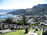
. The town is situated on the lower slopes of the Port Hills
, which form the northern side of the harbour and effectively separate Lyttelton from the city of Christchurch. This steep-sided crater rim acts as a natural amphitheatre and a boundary to urban development.
A tunnel through the Port Hills provides direct road access to Christchurch, 12 km to the north-west. The town of Sumner, some 6 km to the north-east, is accessed via Evans Pass. Another settlement at Governors Bay lies 10 km to the west and a ferry service connects the suburb of Diamond Harbour
on the southern shore of the harbour.
The uninhabited Quail Island sits in the upper harbour southwest of Lyttelton.
 A home for Māori for about 700 years, Lyttelton Harbour was discovered by Europe
an settlers on 16 February 1770 during the Endeavour's
first voyage to New Zealand.
In August 1849 it was officially proclaimed a port
.
Lyttelton was formerly called Port Cooper and Port Victoria. It was the original settlement in the district (1850). The name Lyttelton was given to it in honour of George William Lyttelton
of the Canterbury Association, which had led the colonisation of the area.
The Lyttelton Times
was one of the principal newspaper
s of the Canterbury region for 80 years, published from 1851 until 1929, at which time it became the Christchurch Times, until publication ceased in 1935.
Aiming to establish a Church of England
colony in New Zealand, the Canterbury Association
was founded in 1848. As Lyttelton was a harbour, and had a large amount of flat land suitable for farming and development
nearby, it was ideal for a colony. Pilgrim's Rock shows the place where European settlers first set foot in the harbour. The present location of the rock is well inland from the sea, as much of Lyttelton's dockside has been reclaimed from the harbour waters in recent years.
In 1862, the first telegraph transmission in New Zealand was made from Lyttelton Post Office.
In 1870, fire destroyed all the wooden buildings in Norwich Quay, on the main street of Lyttelton.
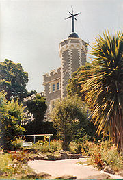
The Lyttelton Timeball Station
was erected in 1876 and was one of the world's five working timeball stations until it was destroyed by an earthquake in 2011. The castle-like building was located high on a ridge above the port with extensive views over the harbour.
On 1 January 1908, the Nimrod Expedition
, headed by Ernest Shackleton
to explore Antarctica left from the harbour here.
The Lyttelton Harbour Board was created in 1877 to be in charge of the harbour's management. It was dissolved in 1989 after the passing of the 1988 Port Companies Act, which forced it to split into two separate organisations, one commercial (the Lyttelton Port Company, currently owned by Christchurch City Holdings
, the commercial arm of the city council) and one non-commercial. In 1996 the Lyttelton Port Company registered on the New Zealand Stock Exchange.
damaged some of Lyttelton's historic buildings, including the Timeball Station
. There was some damage to the town's infrastructure, but the port facilities and tunnel quickly returned to operation. The overall quake damage was less significant than in Christchurch itself, due to the dampening effects of the solid rock that the town rests on and its moderate distance from the epicentre.
On a magnitude 6.3 aftershock caused much more widespread damage in Lyttelton than its predecessor due to its proximity to Lyttelton and a shallow depth of 5 kilometres (3.1 mi). Some walls of the Timeball Station collapsed and there was extensive damage to residential and commercial property, leading to the demolition of a number of high profile heritage buildings such as the Harbour Light Theatre and the Empire Hotel. Many other unreinforced masonry buildings were severely damaged.
Following the February earthquake it was suggested that the Timeball Station be dismantled for safety reasons. Bruce Chapman, chief executive of the New Zealand Historic Places Trust
(NZHPT) said there was a possibility that it may be reconstructed. "If we can find a way to dismantle the Timeball Station that allows us to retain as much of the building's materials as possible, we will do so."
However on Monday 13 June 2011 a further 6.3 ML aftershock brought down the tower and remaining walls while workmen were preparing to dismantle it.
Much of Lyttelton's architectural heritage was lost as a result of the earthquakes, as damage was deemed too extensive for reconstruction. By June 2011, six buildings in London Street in Lyttelton had been demolished, along with another four on Norwich Quay.
The town's oldest churches have collapsed, including Canterbury's oldest stone church, the Holy Trinity.
ratepayers voted to amalgamate with the neighbouring Christchurch City Council
, which took place on 6 March 2006.
 The town is linked to Christchurch by railway and road tunnels through the Port Hills
. At 1.9 km long, the Lyttelton road tunnel
(opened in 1964) is the country's longest road tunnel
; and the railway tunnel
of the Main South Line
, officially opened on 9 December 1867, is the country's oldest.
Between 1958 and 1967 the port saw such prosperity that Kaiapoi
, on the coast north of Christchurch, briefly reopened its closed port facilities for a decade, to allow smaller ships to bypass the congested Lyttelton wharves.
In the 1970s the port was chosen as one of the main ports in the South Island to be dredged and upgraded for containerisation
, with the container facility opening in 1977, the centenary of the initial opening.
Substantial quantities of South Island coal have been shipped from this port for the past 100 years. The port facilities have provided for natural gas and petrol for the past 50 years. In essence the port could be viewed (based on quantities of materials shipped in or out) as the primary port for energy shipments in the South Island.
's 1996 horror movie The Frighteners
.
Port
A port is a location on a coast or shore containing one or more harbors where ships can dock and transfer people or cargo to or from land....
town
Town
A town is a human settlement larger than a village but smaller than a city. The size a settlement must be in order to be called a "town" varies considerably in different parts of the world, so that, for example, many American "small towns" seem to British people to be no more than villages, while...
on the north shore of Lyttelton Harbour
Lyttelton Harbour
Lyttelton Harbour is one of two major inlets in Banks Peninsula, on the coast of Canterbury, New Zealand. The other is Akaroa Harbour.Approximately 15 km in length from its mouth to Teddington, the harbour was formed from a series of ancient volcanic eruptions that created a caldera, the...
close to Banks Peninsula
Banks Peninsula
Banks Peninsula is a peninsula of volcanic origin on the east coast of the South Island of New Zealand. It has an area of approximately and encompasses two large harbours and many smaller bays and coves...
, a suburb
Suburb
The word suburb mostly refers to a residential area, either existing as part of a city or as a separate residential community within commuting distance of a city . Some suburbs have a degree of administrative autonomy, and most have lower population density than inner city neighborhoods...
of Christchurch
Christchurch
Christchurch is the largest city in the South Island of New Zealand, and the country's second-largest urban area after Auckland. It lies one third of the way down the South Island's east coast, just north of Banks Peninsula which itself, since 2006, lies within the formal limits of...
on the eastern coast of the South Island
South Island
The South Island is the larger of the two major islands of New Zealand, the other being the more populous North Island. It is bordered to the north by Cook Strait, to the west by the Tasman Sea, to the south and east by the Pacific Ocean...
of New Zealand
New Zealand
New Zealand is an island country in the south-western Pacific Ocean comprising two main landmasses and numerous smaller islands. The country is situated some east of Australia across the Tasman Sea, and roughly south of the Pacific island nations of New Caledonia, Fiji, and Tonga...
.
Due to its establishment as a landing point for Christchurch-bound seafarers, Lyttelton has historically been regarded as the "Gateway to Canterbury" for colonial settlers. The port remains a regular destination for cruise liners and is the South Island's principal goods transport terminal, handling 34% of exports and 61% of imports by value.
In 2009 Lyttelton was awarded Category I Historic Area status by the New Zealand Historic Places Trust (NZHPT) defined as "an area of special or outstanding historical or cultural heritage significance or value".
According to the 2006 census
New Zealand Census of Population and Dwellings
The New Zealand government department Statistics New Zealand conducts a census of population and dwellings every five years. The census scheduled for 2011 was cancelled due to circumstances surrounding the February 2011 Christchurch earthquake, however, and legislation introduced to hold the next...
, the usual resident population of Lyttelton, including neighbouring communities of Rapaki, Cass Bay and Corsair Bay, was 3,072.
Location
Lyttelton is the largest settlement on Lyttelton Harbour, an inlet on the north-western side of Banks Peninsula extending 18 km inland from the southern end of Pegasus BayPegasus Bay
Pegasus Bay is on the east coast of the South Island of New Zealand.-Location:The bay has a sandy beach and runs from Banks Peninsula to the Waipara River mouth...
. The town is situated on the lower slopes of the Port Hills
Port Hills
The Port Hills form the northern rim of the ancient Lyttelton volcano, separating the port of Lyttelton from the city of Christchurch in Canterbury, New Zealand...
, which form the northern side of the harbour and effectively separate Lyttelton from the city of Christchurch. This steep-sided crater rim acts as a natural amphitheatre and a boundary to urban development.
A tunnel through the Port Hills provides direct road access to Christchurch, 12 km to the north-west. The town of Sumner, some 6 km to the north-east, is accessed via Evans Pass. Another settlement at Governors Bay lies 10 km to the west and a ferry service connects the suburb of Diamond Harbour
Diamond Harbour, New Zealand
Diamond Harbour is a small settlement on Banks Peninsula, in Canterbury, New Zealand. It is on the peninsula's northern coast, on the southern shores of Lyttelton Harbour, and is administratively part of the city of Christchurch....
on the southern shore of the harbour.
The uninhabited Quail Island sits in the upper harbour southwest of Lyttelton.
History
Europe
Europe is, by convention, one of the world's seven continents. Comprising the westernmost peninsula of Eurasia, Europe is generally 'divided' from Asia to its east by the watershed divides of the Ural and Caucasus Mountains, the Ural River, the Caspian and Black Seas, and the waterways connecting...
an settlers on 16 February 1770 during the Endeavour's
HMS Endeavour
HMS Endeavour may refer to one of the following ships:In the Royal Navy:, a 36-gun ship purchased in 1652 and sold in 1656, a 4-gun bomb vessel purchased in 1694 and sold in 1696, a fire ship purchased in 1694 and sold in 1696, a storeship hoy purchased in 1694 and sold in 1705, a storeship...
first voyage to New Zealand.
In August 1849 it was officially proclaimed a port
Port
A port is a location on a coast or shore containing one or more harbors where ships can dock and transfer people or cargo to or from land....
.
Lyttelton was formerly called Port Cooper and Port Victoria. It was the original settlement in the district (1850). The name Lyttelton was given to it in honour of George William Lyttelton
George Lyttelton, 4th Baron Lyttelton
George William Lyttelton, 4th Baron Lyttelton , was a British aristocrat and Conservative politician.-Early life:...
of the Canterbury Association, which had led the colonisation of the area.
The Lyttelton Times
Lyttelton Times
The Lyttelton Times was the first newspaper in Canterbury, New Zealand, publishing the first edition in January 1851. It was established by the Canterbury Association as part of its planned settlement of Canterbury and developed into a liberal, at the time sometimes seen as radical, newspaper...
was one of the principal newspaper
Newspaper
A newspaper is a scheduled publication containing news of current events, informative articles, diverse features and advertising. It usually is printed on relatively inexpensive, low-grade paper such as newsprint. By 2007, there were 6580 daily newspapers in the world selling 395 million copies a...
s of the Canterbury region for 80 years, published from 1851 until 1929, at which time it became the Christchurch Times, until publication ceased in 1935.
Aiming to establish a Church of England
Church of England
The Church of England is the officially established Christian church in England and the Mother Church of the worldwide Anglican Communion. The church considers itself within the tradition of Western Christianity and dates its formal establishment principally to the mission to England by St...
colony in New Zealand, the Canterbury Association
Canterbury Association
The Canterbury Association was formed in order to establish a colony in what is now the Canterbury Region in the South Island of New Zealand.- Formation of the Association :...
was founded in 1848. As Lyttelton was a harbour, and had a large amount of flat land suitable for farming and development
Subdivision (land)
Subdivision is the act of dividing land into pieces that are easier to sell or otherwise develop, usually via a plat. The former single piece as a whole is then known in the United States as a subdivision...
nearby, it was ideal for a colony. Pilgrim's Rock shows the place where European settlers first set foot in the harbour. The present location of the rock is well inland from the sea, as much of Lyttelton's dockside has been reclaimed from the harbour waters in recent years.
In 1862, the first telegraph transmission in New Zealand was made from Lyttelton Post Office.
In 1870, fire destroyed all the wooden buildings in Norwich Quay, on the main street of Lyttelton.
The Lyttelton Timeball Station
Lyttelton Timeball Station
The Lyttelton Timeball Station was a heritage-registered timeball station and prominent local landmark in Lyttelton, New Zealand. The station was significantly damaged by a series of earthquakes and aftershocks in 2010 and 2011, and finally collapsed on the 13 June 2011 after a magnitude 6.3...
was erected in 1876 and was one of the world's five working timeball stations until it was destroyed by an earthquake in 2011. The castle-like building was located high on a ridge above the port with extensive views over the harbour.
On 1 January 1908, the Nimrod Expedition
Nimrod Expedition
The British Antarctic Expedition 1907–09, otherwise known as the Nimrod Expedition, was the first of three expeditions to the Antarctic led by Ernest Shackleton. Its main target, among a range of geographical and scientific objectives, was to be first to the South Pole...
, headed by Ernest Shackleton
Ernest Shackleton
Sir Ernest Henry Shackleton, CVO, OBE was a notable explorer from County Kildare, Ireland, who was one of the principal figures of the period known as the Heroic Age of Antarctic Exploration...
to explore Antarctica left from the harbour here.
The Lyttelton Harbour Board was created in 1877 to be in charge of the harbour's management. It was dissolved in 1989 after the passing of the 1988 Port Companies Act, which forced it to split into two separate organisations, one commercial (the Lyttelton Port Company, currently owned by Christchurch City Holdings
Christchurch City Holdings
Christchurch City Holdings Ltd is a wholly owned investment arm of the Christchurch City Council. The council controlled trading organisations own and run some of the important infrastructure in Christchurch, such as the public transport and electricity delivery in the city.- Lyttelton Port...
, the commercial arm of the city council) and one non-commercial. In 1996 the Lyttelton Port Company registered on the New Zealand Stock Exchange.
Earthquake damage
The 2010 Canterbury earthquake2010 Canterbury earthquake
The 2010 Canterbury earthquake was a 7.1 magnitude earthquake, which struck the South Island of New Zealand at 4:35 am on local time ....
damaged some of Lyttelton's historic buildings, including the Timeball Station
Lyttelton Timeball Station
The Lyttelton Timeball Station was a heritage-registered timeball station and prominent local landmark in Lyttelton, New Zealand. The station was significantly damaged by a series of earthquakes and aftershocks in 2010 and 2011, and finally collapsed on the 13 June 2011 after a magnitude 6.3...
. There was some damage to the town's infrastructure, but the port facilities and tunnel quickly returned to operation. The overall quake damage was less significant than in Christchurch itself, due to the dampening effects of the solid rock that the town rests on and its moderate distance from the epicentre.
On a magnitude 6.3 aftershock caused much more widespread damage in Lyttelton than its predecessor due to its proximity to Lyttelton and a shallow depth of 5 kilometres (3.1 mi). Some walls of the Timeball Station collapsed and there was extensive damage to residential and commercial property, leading to the demolition of a number of high profile heritage buildings such as the Harbour Light Theatre and the Empire Hotel. Many other unreinforced masonry buildings were severely damaged.
Following the February earthquake it was suggested that the Timeball Station be dismantled for safety reasons. Bruce Chapman, chief executive of the New Zealand Historic Places Trust
New Zealand Historic Places Trust
The New Zealand Historic Places Trust is a non-profit trust that advocates for the protection of ancestral sites and heritage buildings in New Zealand...
(NZHPT) said there was a possibility that it may be reconstructed. "If we can find a way to dismantle the Timeball Station that allows us to retain as much of the building's materials as possible, we will do so."
However on Monday 13 June 2011 a further 6.3 ML aftershock brought down the tower and remaining walls while workmen were preparing to dismantle it.
Much of Lyttelton's architectural heritage was lost as a result of the earthquakes, as damage was deemed too extensive for reconstruction. By June 2011, six buildings in London Street in Lyttelton had been demolished, along with another four on Norwich Quay.
The town's oldest churches have collapsed, including Canterbury's oldest stone church, the Holy Trinity.
Governance
On 19 November 2005, it was announced that 60% of the Banks Peninsula DistrictBanks Peninsula District
The Banks Peninsula District was a former territorial authority in New Zealand. It amalgamated with the Christchurch City Council in 2006....
ratepayers voted to amalgamate with the neighbouring Christchurch City Council
Christchurch City Council
The Christchurch City Council is the local government authority for Christchurch in New Zealand. It is a territorial authority elected to represent the people of Christchurch. Since 2007, the Mayor of Christchurch is Bob Parker, who stood as an independent candidate...
, which took place on 6 March 2006.
Transport
Port Hills
The Port Hills form the northern rim of the ancient Lyttelton volcano, separating the port of Lyttelton from the city of Christchurch in Canterbury, New Zealand...
. At 1.9 km long, the Lyttelton road tunnel
Lyttelton Road Tunnel
The Lyttelton road tunnel links the New Zealand city of Christchurch and its seaport, Lyttelton. It opened in 1964 and carries just over 10,000 vehicles/day...
(opened in 1964) is the country's longest road tunnel
Tunnels in New Zealand
This is a link page for railway, road and waterway tunnels, including hydroelectric intakes and tailraces and gun battery tunnels. It includes artificial chambers but excludes New Zealand caves and New Zealand mines.-For hydroelectric usage:...
; and the railway tunnel
Lyttelton rail tunnel
The Lyttelton Rail Tunnel, initially called the Moorhouse Tunnel, links the city of Christchurch with the port of Lyttelton in the Canterbury region of New Zealand’s South Island. It is the country’s oldest operational rail tunnel, and is on one of the first railway lines in the district...
of the Main South Line
Main South Line
The Main South Line, sometimes referred to as part of the South Island Main Trunk Railway, is a railroad line that runs north and south from Lyttelton in New Zealand through Christchurch and along the east coast of the South Island to Invercargill via Dunedin...
, officially opened on 9 December 1867, is the country's oldest.
Lyttelton Port
Lyttelton has long been the main port of the Canterbury / Christchurch area, having been opened in 1877 by the Lyttelton Harbour Board, later becoming the Lyttelton Port Company with the introduction of the Port Companies Act in 1988.Between 1958 and 1967 the port saw such prosperity that Kaiapoi
Kaiapoi
Kaiapoi is a town in the Canterbury region of the South Island of New Zealand, located close to the mouth of the Waimakariri River, and approximately 17 kilometres north of Christchurch....
, on the coast north of Christchurch, briefly reopened its closed port facilities for a decade, to allow smaller ships to bypass the congested Lyttelton wharves.
In the 1970s the port was chosen as one of the main ports in the South Island to be dredged and upgraded for containerisation
Containerization
Containerization is a system of freight transport based on a range of steel intermodal containers...
, with the container facility opening in 1977, the centenary of the initial opening.
Substantial quantities of South Island coal have been shipped from this port for the past 100 years. The port facilities have provided for natural gas and petrol for the past 50 years. In essence the port could be viewed (based on quantities of materials shipped in or out) as the primary port for energy shipments in the South Island.
In popular culture
Lyttelton was the location for most of the exterior scenes in Peter JacksonPeter Jackson
Sir Peter Robert Jackson, KNZM is a New Zealand film director, producer, actor, and screenwriter, known for his The Lord of the Rings film trilogy , adapted from the novel by J. R. R...
's 1996 horror movie The Frighteners
The Frighteners
The Frighteners is a 1996 comedy horror film directed by Peter Jackson and co-written with his wife, Fran Walsh. The film's cast includes Michael J. Fox, Trini Alvarado, John Astin, Jeffrey Combs, Dee Wallace, Jake Busey and Chi McBride...
.