
.gif)
M-183 (Michigan highway)
Encyclopedia
M-183 is a north–south state trunkline highway
in the Upper Peninsula
of the US state of Michigan
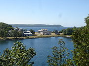
. It serves Fayette State Park as an access route from US Highway 2
(US 2). The highway runs through rural farmlands of the Garden Peninsula
and next to Big Bay de Noc
, a bay of Lake Michigan
. The community at Fayette dates back to the 1860s. It has been a state park since the late 1950s, and the connecting road has been a state highway since the 1980s.
 M-183 lies on the Garden Peninsula in Delta County
. Running along the east shore of Big Bay de Noc
, the highway starts at the gate to Fayette State Park. South of entrance to the park, the roadway continues under local jurisdiction as Delta County Road 483 (CR 483).
From there north, it is a rural two-lane road that runs northeasterly through woodland. The trunkline turns north along LI Road through farmland, and then east along 16th Road near Puffy Bay. South of Garden
, the highway turns north through the village on State Street. M-183 continues north of town running through the farms of the Garden Peninsula along Big Bay de Noc through the Lake Superior State Forest
to the northern terminus at US 2 in Garden Corners.
The Michigan Department of Transportation
(MDOT) maintains the highway like all other state trunkline highways under its jurisdiction. As a part of these responsibilities, the department tracks the volume of traffic along its highways. These surveys are expressed using a metric called average annual daily traffic (AADT), which is a calculation of the traffic counts for a segment of roadway on any average day of the year. In 2009, MDOT determined that 692 vehicles a day used the segment near the state park. Through the middle section in Garden, the peak volume was 892 vehicles daily which dropped to 878 at the US junction. The commercial AADT was 54 trucks for the entire highway. M-183 has not been listed on the National Highway System
, a network of roads important to the country's economy, defense, and mobility.
, the Jackson Iron Company operations lasted here from 1867–1891. The town was used as a location to produce charcoal iron, a purified form of the iron ore mined in the UP. After the furnaces shut down, the town operated as a resort community until the park was created. The Michigan Conservation Department created the park in 1959 after it traded land to obtain the 90 acres (36.4 ha) from the Escanaba Paper Company and the 71 acres (28.7 ha) from Cleveland-Cliffs Iron Company. The Delta County Commission had been requesting state assistance for improving the road since 1975. In February 1985, MDOT took control of the road from the county road commission and designated it M-183. The number was chosen to reflect the CR 483 designation it once bore. After the transfer, the state resurfaced the road as part of a program of improvements to benefit park visitors.
Michigan Highway System
The Michigan State Trunkline Highway System is made up of all the highways designated as Interstates, U.S. Highways and State Highways in the US state of Michigan. The system is maintained by the Michigan Department of Transportation and comprises of trunklines in all 83 counties of Michigan on...
in the Upper Peninsula
Upper Peninsula of Michigan
The Upper Peninsula of Michigan is the northern of the two major land masses that make up the U.S. state of Michigan. It is commonly referred to as the Upper Peninsula, the U.P., or Upper Michigan. It is also known as the land "above the Bridge" linking the two peninsulas. The peninsula is bounded...
of the US state of Michigan
Michigan
Michigan is a U.S. state located in the Great Lakes Region of the United States of America. The name Michigan is the French form of the Ojibwa word mishigamaa, meaning "large water" or "large lake"....
. It serves Fayette State Park as an access route from US Highway 2
U.S. Route 2 in Michigan
US Highway 2 is a component of the United States Numbered Highway System that connects Everett, Washington, to the Upper Peninsula of the US state of Michigan, with a separate segment that runs from Rouses Point, New York, to Houlton, Maine...
(US 2). The highway runs through rural farmlands of the Garden Peninsula
Garden Peninsula
The Garden Peninsula is a peninsula of in length that extends southwestward into Lake Michigan from the mainland of Michigan's Upper Peninsula. The peninsula is bordered by Lake Michigan on the east, and by Big Bay de Noc on the west. The base of the peninsula is served by U.S. Highway 2, and...
and next to Big Bay de Noc
Big Bay de Noc
Big Bay de Noc is a bay in the Upper Peninsula of the U.S. state of Michigan. The bay, which opens into Lake Michigan's Green Bay, is enclosed by Delta County...
, a bay of Lake Michigan
Lake Michigan
Lake Michigan is one of the five Great Lakes of North America and the only one located entirely within the United States. It is the second largest of the Great Lakes by volume and the third largest by surface area, after Lake Superior and Lake Huron...
. The community at Fayette dates back to the 1860s. It has been a state park since the late 1950s, and the connecting road has been a state highway since the 1980s.
Route description
Delta County, Michigan
-Demographics:As of the census of 2000, there were 38,520 people, 15,836 households, and 10,689 families residing in the county. The population density was 33 people per square mile . There were 19,223 housing units at an average density of 16 per square mile...
. Running along the east shore of Big Bay de Noc
Big Bay de Noc
Big Bay de Noc is a bay in the Upper Peninsula of the U.S. state of Michigan. The bay, which opens into Lake Michigan's Green Bay, is enclosed by Delta County...
, the highway starts at the gate to Fayette State Park. South of entrance to the park, the roadway continues under local jurisdiction as Delta County Road 483 (CR 483).
From there north, it is a rural two-lane road that runs northeasterly through woodland. The trunkline turns north along LI Road through farmland, and then east along 16th Road near Puffy Bay. South of Garden
Garden, Michigan
Garden is a village in Delta County of the U.S. state of Michigan. As of the 2000 census, the village had a total population of 240. The village is located within Garden Township....
, the highway turns north through the village on State Street. M-183 continues north of town running through the farms of the Garden Peninsula along Big Bay de Noc through the Lake Superior State Forest
Lake Superior State Forest
Lake Superior State Forest is a state forest in the Upper Peninsula of Michigan. It is operated by the Michigan Department of Natural Resources. The North Country Trail utilizes this state forest for 43 miles of its route....
to the northern terminus at US 2 in Garden Corners.
The Michigan Department of Transportation
Michigan Department of Transportation
The Michigan Department of Transportation is a constitutional government agency in the US state of Michigan. The primary purpose of MDOT is to maintain the Michigan State Trunkline Highway System which includes all Interstate, US and state highways in Michigan with the exception of the Mackinac...
(MDOT) maintains the highway like all other state trunkline highways under its jurisdiction. As a part of these responsibilities, the department tracks the volume of traffic along its highways. These surveys are expressed using a metric called average annual daily traffic (AADT), which is a calculation of the traffic counts for a segment of roadway on any average day of the year. In 2009, MDOT determined that 692 vehicles a day used the segment near the state park. Through the middle section in Garden, the peak volume was 892 vehicles daily which dropped to 878 at the US junction. The commercial AADT was 54 trucks for the entire highway. M-183 has not been listed on the National Highway System
National Highway System (United States)
The National Highway System is a network of strategic highways within the United States, including the Interstate Highway System and other roads serving major airports, ports, rail or truck terminals, railway stations, pipeline terminals and other strategic transport facilities.Individual states...
, a network of roads important to the country's economy, defense, and mobility.
History
Fayette State Park encompasses an historical iron smelting town site from the 1800s. Now a ghost townGhost town
A ghost town is an abandoned town or city. A town often becomes a ghost town because the economic activity that supported it has failed, or due to natural or human-caused disasters such as floods, government actions, uncontrolled lawlessness, war, or nuclear disasters...
, the Jackson Iron Company operations lasted here from 1867–1891. The town was used as a location to produce charcoal iron, a purified form of the iron ore mined in the UP. After the furnaces shut down, the town operated as a resort community until the park was created. The Michigan Conservation Department created the park in 1959 after it traded land to obtain the 90 acres (36.4 ha) from the Escanaba Paper Company and the 71 acres (28.7 ha) from Cleveland-Cliffs Iron Company. The Delta County Commission had been requesting state assistance for improving the road since 1975. In February 1985, MDOT took control of the road from the county road commission and designated it M-183. The number was chosen to reflect the CR 483 designation it once bore. After the transfer, the state resurfaced the road as part of a program of improvements to benefit park visitors.