Mabla Mountains
Encyclopedia
The Mabla Mountains are located in Obock Region
, Djibouti
, Africa
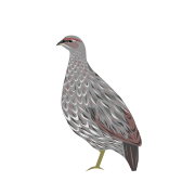
. The endemic Djibouti Francolin
makes its home here and in the Forêt du Day
.

, a port town. At 5850 feet (1,783.1 m) above sea level
, the mountains are situated behind the coastal plain where the Red Sea
meets the Gulf of Aden
. Situated on the northern side of the Gulf of Tadjoura
, the mountains are characterized as a highland
region.
The mountains consist of a range that extends north from near Ras Duan, a steep cliff. Accolado Mount (Assasanto), 1204 feet (367 m) above sea level, is the north mount of the east branch of the Mabla Mountains; it is located 6 miles northwest of the Latela Valley entrance. Morne Rouge, 426 feet (129.8 m) above sea level, is 3 miles north-northwest of the valley entrance. It has three round summits which are formed of reddish stones. Morne Blanc, 1 miles west-southwestof Morne Rouge, is a cone of a greyish appearance. Pic du Hussard (Aramuda) 2612 feet (796.1 m) high is 14 miles north of Ras Duan; it has a large, rounded summit. Minerva's Face, 1.4 miles south-southeast of Pic du Hussard has three summits, the highest of which is 2392 feet (729.1 m) high. Devil's Chair, 4 miles southeast of Minerva's Face, is 1424 feet (434 m) high and clearly visible from seaward.
The annual rainfall measures approximately 20 inches (50.8 cm).
subgroup, Ma`andiyta (or "White"; or Mandita) stayed in the Mabla Mountains, while the Ma`andiyta of Immino (or Awsa, or Aussa, or Assaw ; or "Red") did not. The Mandita are located west of the Mabla Mountains. Another Afar subgroup, the Debne, were settled in the Mabla also. Yet another tribe is the Basooma.
The dabou, a permanent stone dwelling, is found in certain high ground regions, such as the Mabla and Goda Mountains
, as well as in in Ethiopia
with the Afar.
 The endemic, Critically Endangered
Djibouti Francolin was first recorded here in 1985, with the nearby Forêt du Day being its only other location.
In the 1920s, the mountains were thickly covered with trees. The terrain includes box
(Frais spp.) and acacia
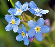
s, as well as palm groves within ravines. Higher elevations of 1300–1600 m (4,265.1–5,249.3 ) are home to juniper
forest that include tall arborescens Euphorbia, and flowering herbs such as Forget-me-not
. Near the summit can be found ferns.
Conservation
In recent years, the forest has been damaged severely, chiefly through forest fires, the grazing of cattle, the felling of its trees, as well as military requirements. In the 1980s, a proposal was made to establish a national park in the mountains' Goula Region.
Obock Region
The Obock Region is one of the six Regions of Djibouti. The Region borders the Red Sea and Gulf of Aden to the east and south, Eritrea to the north, and the Tadjoura Region to the west....
, Djibouti
Djibouti
Djibouti , officially the Republic of Djibouti , is a country in the Horn of Africa. It is bordered by Eritrea in the north, Ethiopia in the west and south, and Somalia in the southeast. The remainder of the border is formed by the Red Sea and the Gulf of Aden at the east...
, Africa
Africa
Africa is the world's second largest and second most populous continent, after Asia. At about 30.2 million km² including adjacent islands, it covers 6% of the Earth's total surface area and 20.4% of the total land area...
. The endemic Djibouti Francolin
Djibouti Francolin
The Djibouti Francolin, Pternistis ochropectus, is one of over forty species of francolins, a group of birds in the Phasianidae family. It is critically endangered and found only in Djibouti, a nation in eastern Africa. This species is grayish-brown overall with white stripes and streaks on its...
makes its home here and in the Forêt du Day
Day Forest National Park
Day Forest National Park is a national park in Djibouti. It protects an important forest island in a sea of semi-desert, with at least four known endemic plant species, which include: Juniperus procera, Olea africana, Buxus hildebrantii, and Tarchonanthus camphoratus...
.

Geography
The Mabla Mountains are located in Obock Region, 25 kilometres (15.5 mi) west of ObockObock
Obock is a small port town in Djibouti. It is located on the northern shore of the Gulf of Tadjoura, where it opens out into the Gulf of Aden. The population in 2003 was about 8,300 inhabitants....
, a port town. At 5850 feet (1,783.1 m) above sea level
Above mean sea level
The term above mean sea level refers to the elevation or altitude of any object, relative to the average sea level datum. AMSL is used extensively in radio by engineers to determine the coverage area a station will be able to reach...
, the mountains are situated behind the coastal plain where the Red Sea
Red Sea
The Red Sea is a seawater inlet of the Indian Ocean, lying between Africa and Asia. The connection to the ocean is in the south through the Bab el Mandeb strait and the Gulf of Aden. In the north, there is the Sinai Peninsula, the Gulf of Aqaba, and the Gulf of Suez...
meets the Gulf of Aden
Gulf of Aden
The Gulf of Aden is located in the Arabian Sea between Yemen, on the south coast of the Arabian Peninsula, and Somalia in the Horn of Africa. In the northwest, it connects with the Red Sea through the Bab-el-Mandeb strait, which is about 20 miles wide....
. Situated on the northern side of the Gulf of Tadjoura
Gulf of Tadjoura
The Gulf of Tadjoura is a gulf or basin of the Indian Ocean in the Horn of Africa. It lies south of the straits of Bab-el-Mandeb, or the entrance to the Red Sea, at . Most of its coastline is the territory of Djibouti, except for a short stretch on the southern shore, which is part of the...
, the mountains are characterized as a highland
Highland (geography)
The term highland or upland is used to denote any mountainous region or elevated mountainous plateau. Generally speaking, the term upland tends to be used for ranges of hills, typically up to 500-600m, and highland for ranges of low mountains.The Scottish Highlands refers to the mountainous...
region.
The mountains consist of a range that extends north from near Ras Duan, a steep cliff. Accolado Mount (Assasanto), 1204 feet (367 m) above sea level, is the north mount of the east branch of the Mabla Mountains; it is located 6 miles northwest of the Latela Valley entrance. Morne Rouge, 426 feet (129.8 m) above sea level, is 3 miles north-northwest of the valley entrance. It has three round summits which are formed of reddish stones. Morne Blanc, 1 miles west-southwestof Morne Rouge, is a cone of a greyish appearance. Pic du Hussard (Aramuda) 2612 feet (796.1 m) high is 14 miles north of Ras Duan; it has a large, rounded summit. Minerva's Face, 1.4 miles south-southeast of Pic du Hussard has three summits, the highest of which is 2392 feet (729.1 m) high. Devil's Chair, 4 miles southeast of Minerva's Face, is 1424 feet (434 m) high and clearly visible from seaward.
The annual rainfall measures approximately 20 inches (50.8 cm).
Culture
An Afar peopleAfar people
The Afar , also known as the Danakil, are an ethnic group in the Horn of Africa. They primarily live in the Afar Region of Ethiopia and in northern Djibouti, although some also inhabit the southern point of Eritrea.-Early history:...
subgroup, Ma`andiyta (or "White"; or Mandita) stayed in the Mabla Mountains, while the Ma`andiyta of Immino (or Awsa, or Aussa, or Assaw ; or "Red") did not. The Mandita are located west of the Mabla Mountains. Another Afar subgroup, the Debne, were settled in the Mabla also. Yet another tribe is the Basooma.
The dabou, a permanent stone dwelling, is found in certain high ground regions, such as the Mabla and Goda Mountains
Goda Mountains
The Goda Mountains lie northwest of the Gulf of Tadjoura, Afar region in Djibouti. They rise to above sea level and are the nation's largest vegetated area...
, as well as in in Ethiopia
Ethiopia
Ethiopia , officially known as the Federal Democratic Republic of Ethiopia, is a country located in the Horn of Africa. It is the second-most populous nation in Africa, with over 82 million inhabitants, and the tenth-largest by area, occupying 1,100,000 km2...
with the Afar.
Flora and fauna

Critically Endangered
Critically Endangered is the highest risk category assigned by the IUCN Red List for wild species. Critically Endangered means that a species' numbers have decreased, or will decrease, by 80% within three generations....
Djibouti Francolin was first recorded here in 1985, with the nearby Forêt du Day being its only other location.
In the 1920s, the mountains were thickly covered with trees. The terrain includes box
Buxus
Buxus is a genus of about 70 species in the family Buxaceae. Common names include box or boxwood ....
(Frais spp.) and acacia
Acacia
Acacia is a genus of shrubs and trees belonging to the subfamily Mimosoideae of the family Fabaceae, first described in Africa by the Swedish botanist Carl Linnaeus in 1773. Many non-Australian species tend to be thorny, whereas the majority of Australian acacias are not...
s, as well as palm groves within ravines. Higher elevations of 1300–1600 m (4,265.1–5,249.3 ) are home to juniper
Juniper
Junipers are coniferous plants in the genus Juniperus of the cypress family Cupressaceae. Depending on taxonomic viewpoint, there are between 50-67 species of juniper, widely distributed throughout the northern hemisphere, from the Arctic, south to tropical Africa in the Old World, and to the...
forest that include tall arborescens Euphorbia, and flowering herbs such as Forget-me-not
Forget-me-not
Myosotis is a genus of flowering plants in the family Boraginaceae that are commonly called Forget-me-nots. Its common name was calqued from the French, "ne m'oubliez pas" and first used in English in c. 1532. Similar names and variations are found in many languages.-Description:There are...
. Near the summit can be found ferns.
Conservation
In recent years, the forest has been damaged severely, chiefly through forest fires, the grazing of cattle, the felling of its trees, as well as military requirements. In the 1980s, a proposal was made to establish a national park in the mountains' Goula Region.

