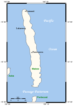
Maewo
Encyclopedia

Vanuatu
Vanuatu , officially the Republic of Vanuatu , is an island nation located in the South Pacific Ocean. The archipelago, which is of volcanic origin, is some east of northern Australia, northeast of New Caledonia, west of Fiji, and southeast of the Solomon Islands, near New Guinea.Vanuatu was...
in Penama province, 105 km to the east of Espiritu Santo
Espiritu Santo
Espiritu Santo is the largest island in the nation of Vanuatu, with an area of . It belongs to the archipelago of the New Hebrides in the Pacific region of Melanesia. It is in the Sanma Province of Vanuatu....
. It is 47 km long, and 6 km wide, with an area of 269 km². Its highest point is 795 m above sea level
Sea level
Mean sea level is a measure of the average height of the ocean's surface ; used as a standard in reckoning land elevation...
. In 1979 the island had a population of 1772.
Maewo is the island with the highest rainfall in Vanuatu, greater than 2500 mm per year.
The island is covered in green, lush vegetation. The heavy rainfall provides abundant fresh water and waterfalls. There are also hot springs in the centre of Maewo.
The most notable village on the island is Lakarere, on the northwest coast.

