
Makushin Volcano
Encyclopedia
The Makushin Volcano is an ice-covered stratovolcano
located on Unalaska Island
in the Aleutian Islands of the U.S. state
of Alaska
. With an elevation of 2036 metres (6,679.8 ft), it's summit is the highest point on the island. Makushin is one of the most active among the 40 volcanoes of Alaska. It has erupted at least two dozen times over the past several thousand years, with the last eruption occurring in 1995.
word makushka, meaning "the top (of the head)". Its native name was Aigagin, a derivative of the word Aigak in the native tongue of the Aleuts.
Makushin was also the native village here on the northern shore of the Makushin Bay where the foreman or bidarshik of the Russian American Company lived. There were six huts (yourts) where 35 natives lived.
Alaska Volcano Observatory has identified "Ajagin Wesselow", "Makushin Volcano", "Ajagisch", "Makouchine", "Ognedieshutshai Gora", "Ayagsh", "Aiyagin", "Cheerful Mtn.", "Ayyagyh", "Ayagish", "Makuschkin Volcano", "Ognedyshushchaya Gora" and "Makishinskaia sopka" as alternate names for the Makushin Volcano. Specifically identified here are the four features namely, Red Cinder Dome, Pakushin cone, the Sugarloaf and the Point Kadin vents.
According to the history recorded by the Alaska Volcano Observatory
: “The first episode began in Pliocene or early Pleistocene time (the oldest known age of lavas is 0.93 Ma [Nye, 1990]) and produced extensive flows and subordinate pyroclastic deposits of basaltic and andesitic composition, which enlarged the island by several kilometers along the northwest coast. Radial dips of flows suggest that Makushin Volcano itself was the principal vent area. The older flows are extensively glaciated, which implies a minimum age of late Pleistocene. The summit of Makushin subsequently collapsed, forming a caldera. Andesitic pyroclastic-flow and debris flow deposits occur in glaciated valleys on the north and south sides of the volcano indicating a Holocene age for the caldera-forming eruption."
Although the volcano has not erupted since 1995, studies conducted between July 1996 and August 2000 recorded some 176 minor earthquakes registering between 0.1 and 3.2 on the Richter Scale, occurring on average 2 to 3 times a month. The hypocenter
s of the earthquakes generally occur in two cluster areas, the first is the larger and more active, located about 6 kilometres (3.7 mi) southeast of the summit of the volcano at depths ranging from 2–9 km (1.2–5.6 mi) and the second, about 24 kilometres (14.9 mi) east of the summit under Unalaska Bay occurs at depths of 6–14 km (3.7–8.7 mi).
The volcano was climbed by English born American geographer George Davidson
in 1867 who conducted some important geographical and geological research into the volcano area and the Makushin valley.
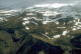
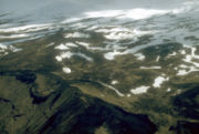
Mount Makushin is located on the northern Unalaska Island, which is situated to west of the town of Dutch Harbor. The Unalaska Bay, which is 10 kilometres (6.2 mi) wide, separates the Dutch Harbor and Unalaska towns. The volcano is truncated, with a width of 16 kilometres (9.9 mi), forming the triangular northwest extension of the Unalaska Island. The caldera, which crowns the volcano, has a width of 2.5 kilometres (1.6 mi) (3 kilometres (1.9 mi) is also mentioned in another reference). Compared with the other Aleutian strato-volcanoes in the region, which have steep profiles, the Makushin volcano is a contrast that exhibits a broad and dome like structure with an ice field coverage of 40 square kilometre. Fumaroles and hot springs in area form a roughly linear trend. About 8 kilometres (5 mi) to the south of this volcano is the “composite Pakushin cone” that has multiple craters, which is 4000 years old eruption; pyroclastic flows and surges have been reported here. The southeast flank of the volcano has rock exposures, at 975 metres (3,198.8 ft) elevation.
The pyroclastic flows deposited by the eruptions forming the Caldera have engulfed valleys in the eastern, northeastern, northern, and western valleys of the valley with depths up to 100 m. The northeast border of the volcano is also filled with volcanic lava, which is called the “Lava Ramp” spreading to an area of 50 square kilometre. A subsidiary cone formed is the Pakushin Cone), on the south. In the east and southeast part of the volcano hot springs and fumaroles have been created, at the summit and in valleys. A valley of the same name stretches to the northeast of the volcano from Broad Bay in Captain's Bay and was identified as a glacial valley after a survey in 1873.
The terrain surrounding the volcano is very rugged but most of the surface surrounding the volcano is vegetated. However, it is generally less pronounced in the area of pyroclastic flows and deposits. Areas of short and tall grass grow in the volcano area, ranging from less than 20 cm high to over 1 meter.
John Muir
, the Scottish-born American naturalist (1838–1914), in his book "The Cruise of the Corwin (1881)", has vividly described this volcano:
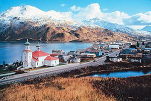 The closest town to the Volcano is the Unalaska town which is located 1280 kilometres (795.4 mi) from Anchorage on the Aleutian Archipelago at the northern end of the Island. It is situated on a well protected bay. This was at the cross roads of shipping and trade during Russia
n occupation (1741–1867). Dutch Harbor another important harbor town across the Unalaska town was a major naval base during the World War II. Fishing and crabbing industries have been the mainstay of the economy of Unalaska island.
areas in the summit caldera peak and also on the southeastern and eastern flanks of the Makushin. It is recorded as a subduction-related volcanic arc in the middle of the great Aleutian
chain.
Energy resources from the Geothermal reservoir beneath the volcano have been assessed in a study carried out by the Alaska Power Authority to meet the power demands of the town of Unalaska and the Dutch Harbor. The study has established that such an energy generation from the geothermal resources would be cheaper than the diesel power system existing on the island.
Stratovolcano
A stratovolcano, also known as a composite volcano, is a tall, conical volcano built up by many layers of hardened lava, tephra, pumice, and volcanic ash. Unlike shield volcanoes, stratovolcanoes are characterized by a steep profile and periodic, explosive eruptions...
located on Unalaska Island
Unalaska Island
Unalaska is an island in the Fox Islands group of the Aleutian Islands in the U.S. state of Alaska, at . The island has a land area of . The city of Unalaska, Alaska, covers part of the island and all of neighboring Amaknak Island where the Port of Dutch Harbor is located...
in the Aleutian Islands of the U.S. state
U.S. state
A U.S. state is any one of the 50 federated states of the United States of America that share sovereignty with the federal government. Because of this shared sovereignty, an American is a citizen both of the federal entity and of his or her state of domicile. Four states use the official title of...
of Alaska
Alaska
Alaska is the largest state in the United States by area. It is situated in the northwest extremity of the North American continent, with Canada to the east, the Arctic Ocean to the north, and the Pacific Ocean to the west and south, with Russia further west across the Bering Strait...
. With an elevation of 2036 metres (6,679.8 ft), it's summit is the highest point on the island. Makushin is one of the most active among the 40 volcanoes of Alaska. It has erupted at least two dozen times over the past several thousand years, with the last eruption occurring in 1995.
Etymology
In 1792, Sarichev called the volcano "Ognedyshushchaya Gora" meaning "fire erupting mountain", i.e. volcano in Russian. In 1825, it was known as Makuschkin Volcano, possibly from the RussianRussian language
Russian is a Slavic language used primarily in Russia, Belarus, Uzbekistan, Kazakhstan, Tajikistan and Kyrgyzstan. It is an unofficial but widely spoken language in Ukraine, Moldova, Latvia, Turkmenistan and Estonia and, to a lesser extent, the other countries that were once constituent republics...
word makushka, meaning "the top (of the head)". Its native name was Aigagin, a derivative of the word Aigak in the native tongue of the Aleuts.
Makushin was also the native village here on the northern shore of the Makushin Bay where the foreman or bidarshik of the Russian American Company lived. There were six huts (yourts) where 35 natives lived.
Alaska Volcano Observatory has identified "Ajagin Wesselow", "Makushin Volcano", "Ajagisch", "Makouchine", "Ognedieshutshai Gora", "Ayagsh", "Aiyagin", "Cheerful Mtn.", "Ayyagyh", "Ayagish", "Makuschkin Volcano", "Ognedyshushchaya Gora" and "Makishinskaia sopka" as alternate names for the Makushin Volcano. Specifically identified here are the four features namely, Red Cinder Dome, Pakushin cone, the Sugarloaf and the Point Kadin vents.
Origins
The history of the volcano has been identified with the early Pliocene age. However, the caldera of the volcano is dated to a comparatively recent history of 8000 years. The “Sugarloaf cone on the ENE flank, and a cluster of about a dozen explosion pits and cinder cones at Point Kadin on the WNW flank” is attributed to the Holocene age.According to the history recorded by the Alaska Volcano Observatory
Alaska Volcano Observatory
The Alaska Volcano Observatory is a joint program of the United States Geological Survey, the Geophysical Institute of the University of Alaska Fairbanks, and the State of Alaska Division of Geological and Geophysical Surveys...
: “The first episode began in Pliocene or early Pleistocene time (the oldest known age of lavas is 0.93 Ma [Nye, 1990]) and produced extensive flows and subordinate pyroclastic deposits of basaltic and andesitic composition, which enlarged the island by several kilometers along the northwest coast. Radial dips of flows suggest that Makushin Volcano itself was the principal vent area. The older flows are extensively glaciated, which implies a minimum age of late Pleistocene. The summit of Makushin subsequently collapsed, forming a caldera. Andesitic pyroclastic-flow and debris flow deposits occur in glaciated valleys on the north and south sides of the volcano indicating a Holocene age for the caldera-forming eruption."
Activity
Historically, Makushin is one of the most active volcanoes in the Aleutian Islands, erupting at least two dozen times over the past several thousands years, the last in 1995. Seventeen explosions or eruptions of the Makushin Volcano have been recorded since 1786, though the magnitude has been termed as “small-to-moderate”. These were recorded in the years 1768–69, 1790?, 1792?, 1802, 1818?, 1826–38?, 1844?, 1865, 1867?, 1883, 1907, 1912?, 1926, 1938, 1951, 1952?, 1980, 1987 and 1995. Makushin’s pinnacle last erupted on January 30, 1995, which generated ash extending to an altitude of 2.5 km. In the 1987 eruption, which occurred on March 2, the plume rose to 900 metres (2,952.8 ft) above the volcano. The 1980 eruption was comparatively of smaller magnitude emanating from a vent on the southern side about 60 metres (196.9 ft) below the volcanic peak.Although the volcano has not erupted since 1995, studies conducted between July 1996 and August 2000 recorded some 176 minor earthquakes registering between 0.1 and 3.2 on the Richter Scale, occurring on average 2 to 3 times a month. The hypocenter
Hypocenter
The hypocenter refers to the site of an earthquake or a nuclear explosion...
s of the earthquakes generally occur in two cluster areas, the first is the larger and more active, located about 6 kilometres (3.7 mi) southeast of the summit of the volcano at depths ranging from 2–9 km (1.2–5.6 mi) and the second, about 24 kilometres (14.9 mi) east of the summit under Unalaska Bay occurs at depths of 6–14 km (3.7–8.7 mi).
The volcano was climbed by English born American geographer George Davidson
George Davidson (geographer)
George Davidson was an geodesist, astronomer, geographer, surveyor and engineer in the United States.-Biography:Born May 9, 1825 in England, he came to the U.S. in 1832 with his parents, who settled in Pennsylvania...
in 1867 who conducted some important geographical and geological research into the volcano area and the Makushin valley.
Geography
 |
Mount Makushin is located on the northern Unalaska Island, which is situated to west of the town of Dutch Harbor. The Unalaska Bay, which is 10 kilometres (6.2 mi) wide, separates the Dutch Harbor and Unalaska towns. The volcano is truncated, with a width of 16 kilometres (9.9 mi), forming the triangular northwest extension of the Unalaska Island. The caldera, which crowns the volcano, has a width of 2.5 kilometres (1.6 mi) (3 kilometres (1.9 mi) is also mentioned in another reference). Compared with the other Aleutian strato-volcanoes in the region, which have steep profiles, the Makushin volcano is a contrast that exhibits a broad and dome like structure with an ice field coverage of 40 square kilometre. Fumaroles and hot springs in area form a roughly linear trend. About 8 kilometres (5 mi) to the south of this volcano is the “composite Pakushin cone” that has multiple craters, which is 4000 years old eruption; pyroclastic flows and surges have been reported here. The southeast flank of the volcano has rock exposures, at 975 metres (3,198.8 ft) elevation.
The pyroclastic flows deposited by the eruptions forming the Caldera have engulfed valleys in the eastern, northeastern, northern, and western valleys of the valley with depths up to 100 m. The northeast border of the volcano is also filled with volcanic lava, which is called the “Lava Ramp” spreading to an area of 50 square kilometre. A subsidiary cone formed is the Pakushin Cone), on the south. In the east and southeast part of the volcano hot springs and fumaroles have been created, at the summit and in valleys. A valley of the same name stretches to the northeast of the volcano from Broad Bay in Captain's Bay and was identified as a glacial valley after a survey in 1873.
The terrain surrounding the volcano is very rugged but most of the surface surrounding the volcano is vegetated. However, it is generally less pronounced in the area of pyroclastic flows and deposits. Areas of short and tall grass grow in the volcano area, ranging from less than 20 cm high to over 1 meter.
John Muir
John Muir
John Muir was a Scottish-born American naturalist, author, and early advocate of preservation of wilderness in the United States. His letters, essays, and books telling of his adventures in nature, especially in the Sierra Nevada mountains of California, have been read by millions...
, the Scottish-born American naturalist (1838–1914), in his book "The Cruise of the Corwin (1881)", has vividly described this volcano:
Russia
Russia or , officially known as both Russia and the Russian Federation , is a country in northern Eurasia. It is a federal semi-presidential republic, comprising 83 federal subjects...
n occupation (1741–1867). Dutch Harbor another important harbor town across the Unalaska town was a major naval base during the World War II. Fishing and crabbing industries have been the mainstay of the economy of Unalaska island.
Research studies
The high-temperature geothermal resources study of volcanoes in Alaska has covered the GeothermalGeothermal
Geothermal is related to energy and may refer to:* The geothermal gradient and associated heat flows from within the Earth- Renewable technology :...
areas in the summit caldera peak and also on the southeastern and eastern flanks of the Makushin. It is recorded as a subduction-related volcanic arc in the middle of the great Aleutian
Aleutian
Aleutian may refer to:*The Aleut people, the indigenous people of the Aleutian Islands, the Pribilof Islands, the Shumagin Islands, and the far western part of the Alaska Peninsula in Alaska and of Kamchatka Krai, Russia....
chain.
Energy resources from the Geothermal reservoir beneath the volcano have been assessed in a study carried out by the Alaska Power Authority to meet the power demands of the town of Unalaska and the Dutch Harbor. The study has established that such an energy generation from the geothermal resources would be cheaper than the diesel power system existing on the island.