

Malheur Butte
Encyclopedia
Malheur Butte is an extinct volcano
located in Malheur County, Oregon
. Between 20 and 15 million years ago, the region from north-central Washington to northeastern California
experienced a series of volcanic eruptions and basalt lava floods that covered thousands of square miles. These ancient lava floods often dammed streams, creating lakes and swamps that may have lasted for millions of years before filling with sediment or draining as erosion slowly lowered their outlets. The western Snake River
plain contained many such lakes, and geologists believe that between 8 and 2 million years ago, "Lake Idaho" covered much of central eastern Oregon
. Sediment deposited in this lake once covered Malheur Butte, and during the last 2 million years the Malheur River
and other eroding forces slowly exposed and shaped today's landmark.
Although Malheur Butte has been inactive for millions of years, Malheur County is still alive with geothermal activity in the form of hot spring
s. Today, Oregon Trail Mushroom uses geothermal energy
at their processing plant in Vale, and efforts are being made to further utilize this unique energy source throughout the country.
The rock is slightly over 100 meters higher than the surrounding plains and the peak is 790 meters above sea level.
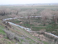 Malheur is French for "misfortune," "bad fortune," or "unhappiness," most likely taken from the Malheur River
that flows nearby. Peter Skene Ogden, a trader accompanied by French-Canadian hunters, explained in his journal in 1826 that the Malheur River
was so named because property and furs that had been hidden in the vicinity had been discovered and stolen by natives.
Volcano
2. Bedrock3. Conduit 4. Base5. Sill6. Dike7. Layers of ash emitted by the volcano8. Flank| 9. Layers of lava emitted by the volcano10. Throat11. Parasitic cone12. Lava flow13. Vent14. Crater15...
located in Malheur County, Oregon
Malheur County, Oregon
Malheur County is a county located in the southeast corner of the U.S. state of Oregon. It is included in the eight-county definition of Eastern Oregon. Most of the county observes the Mountain Time Zone, although the southern quarter of the county observes the Pacific Time Zone along with the...
. Between 20 and 15 million years ago, the region from north-central Washington to northeastern California
California
California is a state located on the West Coast of the United States. It is by far the most populous U.S. state, and the third-largest by land area...
experienced a series of volcanic eruptions and basalt lava floods that covered thousands of square miles. These ancient lava floods often dammed streams, creating lakes and swamps that may have lasted for millions of years before filling with sediment or draining as erosion slowly lowered their outlets. The western Snake River
Snake River
The Snake is a major river of the greater Pacific Northwest in the United States. At long, it is the largest tributary of the Columbia River, the largest North American river that empties into the Pacific Ocean...
plain contained many such lakes, and geologists believe that between 8 and 2 million years ago, "Lake Idaho" covered much of central eastern Oregon
Oregon
Oregon is a state in the Pacific Northwest region of the United States. It is located on the Pacific coast, with Washington to the north, California to the south, Nevada on the southeast and Idaho to the east. The Columbia and Snake rivers delineate much of Oregon's northern and eastern...
. Sediment deposited in this lake once covered Malheur Butte, and during the last 2 million years the Malheur River
Malheur River
The Malheur River is a tributary of the Snake River in eastern Oregon in the United States. It drains a high desert area, between the Harney Basin and the Blue Mountains and the Snake....
and other eroding forces slowly exposed and shaped today's landmark.
Although Malheur Butte has been inactive for millions of years, Malheur County is still alive with geothermal activity in the form of hot spring
Hot spring
A hot spring is a spring that is produced by the emergence of geothermally heated groundwater from the Earth's crust. There are geothermal hot springs in many locations all over the crust of the earth.-Definitions:...
s. Today, Oregon Trail Mushroom uses geothermal energy
Geothermal power
Geothermal energy is thermal energy generated and stored in the Earth. Thermal energy is the energy that determines the temperature of matter. Earth's geothermal energy originates from the original formation of the planet and from radioactive decay of minerals...
at their processing plant in Vale, and efforts are being made to further utilize this unique energy source throughout the country.
The rock is slightly over 100 meters higher than the surrounding plains and the peak is 790 meters above sea level.
Etymology
Malheur River
The Malheur River is a tributary of the Snake River in eastern Oregon in the United States. It drains a high desert area, between the Harney Basin and the Blue Mountains and the Snake....
that flows nearby. Peter Skene Ogden, a trader accompanied by French-Canadian hunters, explained in his journal in 1826 that the Malheur River
Malheur River
The Malheur River is a tributary of the Snake River in eastern Oregon in the United States. It drains a high desert area, between the Harney Basin and the Blue Mountains and the Snake....
was so named because property and furs that had been hidden in the vicinity had been discovered and stolen by natives.