

Manhattan micropolitan area
Encyclopedia
United States Census Bureau
The United States Census Bureau is the government agency that is responsible for the United States Census. It also gathers other national demographic and economic data...
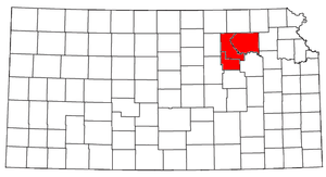
, is an area consisting of three counties in northeastern Kansas
Kansas
Kansas is a US state located in the Midwestern United States. It is named after the Kansas River which flows through it, which in turn was named after the Kansa Native American tribe, which inhabited the area. The tribe's name is often said to mean "people of the wind" or "people of the south...
, anchored by the city of Manhattan
Manhattan, Kansas
Manhattan is a city located in the northeastern part of the state of Kansas in the United States, at the junction of the Kansas River and Big Blue River. It is the county seat of Riley County and the city extends into Pottawatomie County. As of the 2010 census, the city population was 52,281...
. It was upgraded from a Micropolitan Statistical Area (μSA) to a Metropolitan Statistical Area (MSA) by the Office of Management and Budget on November 20, 2008.
As of the 2000 census
United States Census, 2000
The Twenty-second United States Census, known as Census 2000 and conducted by the Census Bureau, determined the resident population of the United States on April 1, 2000, to be 281,421,906, an increase of 13.2% over the 248,709,873 persons enumerated during the 1990 Census...
, the μSA had a population of 108,999 (though a July 1, 2009 estimate placed the population at 123,086).
Counties
- GearyGeary County, KansasGeary County is a county located in Northeast Kansas, in the Central United States. As of the 2010 census, the county population was 34,362. Its county seat and most populous city is Junction City. The county is named in honor of Governor John W. Geary...
- PottawatomiePottawatomie County, KansasPottawatomie County is a county located in the U.S. state of Kansas. As of the 2010 census, the county population was 21,604. The county seat is Westmoreland. The county takes its name from the Potawatomi tribe of Native Americans...
- RileyRiley County, KansasRiley County is a county located in the U.S. state of Kansas. The county's population was 71,115 for the 2010 census. The largest city and county seat is Manhattan. The county is part of the Manhattan, Kansas, Metropolitan Statistical Area.Riley County is home to two of Kansas' largest...
Communities
- Places with more than 40,000 inhabitants
- ManhattanManhattan, KansasManhattan is a city located in the northeastern part of the state of Kansas in the United States, at the junction of the Kansas River and Big Blue River. It is the county seat of Riley County and the city extends into Pottawatomie County. As of the 2010 census, the city population was 52,281...
(Principal city)
- Manhattan
- Places with 1,000 to 20,000 inhabitants
- Fort Riley NorthFort Riley North, KansasFort Riley North is a census-designated place that covers part of Fort Riley, a US Army installation in Geary and Riley counties in the U.S. state of Kansas. The area is more commonly known as "Custer Hill"...
(census-designated placeCensus-designated placeA census-designated place is a concentration of population identified by the United States Census Bureau for statistical purposes. CDPs are delineated for each decennial census as the statistical counterparts of incorporated places such as cities, towns and villages...
) - Grandview PlazaGrandview Plaza, KansasGrandview Plaza is a city in Geary County, Kansas, United States. As of the 2010 census, the city population was 1,560. It is part of the Manhattan, Kansas Metropolitan Statistical Area.-Geography:Grandview Plaza is located at...
- Junction CityJunction City, KansasJunction City is a city in and the county seat of Geary County, Kansas, United States. As of the 2010 census, the city population was 23,353. Fort Riley, a major U.S. Army post, is nearby...
- OgdenOgden, KansasOgden is a city in Riley County, Kansas, United States. As of the 2010 census, the city population was 2,087. It is part of the Manhattan, Kansas Metropolitan Statistical Area.-History:...
- St. MarysSt. Marys, KansasSt. Marys is a city in Pottawatomie and Wabaunsee counties in the U.S. state of Kansas, approximately 20 miles west of Topeka on U.S. Route 24. The population was 2,198 at the 2000 census. It is part of the Manhattan, Kansas Metropolitan Statistical Area....
- WamegoWamego, KansasWamego is a city in Pottawatomie County, Kansas, United States. The population was 4,246 at the 2000 census. It is part of the Manhattan, Kansas Metropolitan Statistical Area.-Geography:Wamego is located at...
- Fort Riley North
- Places with 500 to 1,000 inhabitants
- MilfordMilford, KansasMilford is a city in Geary County, Kansas, in the United States. As of the 2010 census, the city population was 530. It is part of the Manhattan, Kansas Metropolitan Statistical Area.-Geography:Milford is located at...
- OnagaOnaga, KansasOnaga is a city in Pottawatomie County, Kansas, United States. As of the 2010 census, the city population was 702. It is part of the Manhattan, Kansas Metropolitan Statistical Area.-Geography:Onaga is located at...
- RileyRiley, KansasRiley is a city in Riley County, Kansas, United States. As of the 2010 census, the city population was TBD. It is part of the Manhattan, Kansas Metropolitan Statistical Area.-Geography:Riley is located at...
- WestmorelandWestmoreland, KansasWestmoreland is a city in and the county seat of Pottawatomie County, Kansas, United States. As of the 2010 census, the city population was 778. Westmoreland is part of the Manhattan, Kansas Metropolitan Statistical Area.-Geography:...
- Milford
- Places with less than 500 inhabitants
- BelvueBelvue, KansasBelvue is a city in Pottawatomie County, Kansas, United States. The population was 228 at the 2000 census. It is part of the Manhattan, Kansas Metropolitan Statistical Area.-Geography:Belvue is located at ....
- EmmettEmmett, KansasEmmett is a city in Pottawatomie County, Kansas, United States. The population was 277 at the 2000 census. It is part of the Manhattan, Kansas Metropolitan Statistical Area.-Geography:Emmett is located at ....
- Fort Riley-Camp WhitesideFort Riley-Camp Whiteside, KansasFort Riley-Camp Whiteside is a census-designated place that covers part of Fort Riley, a US Army installation in Geary County, Kansas, United States...
(census-designated place) - HavensvilleHavensville, KansasHavensville is a city in Pottawatomie County, Kansas, United States. The population was 146 at the 2000 census. It is part of the Manhattan, Kansas Metropolitan Statistical Area.-Geography:Havensville is located at...
- LeonardvilleLeonardville, KansasLeonardville is a city in Riley County, Kansas, United States. As of the 2010 census, the city population was 449. It is part of the Manhattan, Kansas Metropolitan Statistical Area.-Geography:Leonardville is located at...
- LouisvilleLouisville, KansasLouisville is a city in Pottawatomie County, Kansas, United States. The population was 209 at the 2000 census. It is part of the Manhattan, Kansas Metropolitan Statistical Area.-History:...
- OlsburgOlsburg, KansasOlsburg is a city in Pottawatomie County, Kansas, United States. The population was 192 at the 2000 census, unchanged from 1990. It is part of the Manhattan, Kansas Metropolitan Statistical Area.-Geography:Olsburg is located at ....
- RandolphRandolph, KansasRandolph is a city in Riley County, Kansas, United States. As of the 2010 census, the city population was 163. It is part of the Manhattan, Kansas Metropolitan Statistical Area.-History:Randolph was originally located a mile east of its present location....
- St. GeorgeSt. George, KansasSt. George is a city in Pottawatomie County, Kansas, United States. As of the 2010 census, the city population was 639. It is part of the Manhattan, Kansas Metropolitan Statistical Area.-Geography:St. George is located at...
- WheatonWheaton, KansasWheaton is a city in Pottawatomie County, Kansas, United States. The population was 92 at the 2000 census. It is part of the Manhattan, Kansas Metropolitan Statistical Area.-Geography:Wheaton is located at ....
- Belvue
- Unincorporated places
- WrefordWreford, KansasWreford is an unincorporated community in Geary County, Kansas, United States. It is part of the Manhattan, Kansas Metropolitan Statistical Area....
- ZeandaleZeandale, KansasZeandale is an unincorporated community in Riley County, Kansas, United States. It is located east of Manhattan and is part of the Manhattan Metropolitan Statistical Area. The elevation of the community is above sea level. The total population of the township was 357 at the 2000 US census...
- Wreford
Demographics
As of the censusCensus
A census is the procedure of systematically acquiring and recording information about the members of a given population. It is a regularly occurring and official count of a particular population. The term is used mostly in connection with national population and housing censuses; other common...
of 2000, there were 108,999 people, 39,366 households, and 24,774 families residing within the μSA. The racial makeup of the μSA was 81.42% White, 9.73% African American, 0.65% Native American, 2.72% Asian, 0.20% Pacific Islander, 2.24% from other races
Race (United States Census)
Race and ethnicity in the United States Census, as defined by the Federal Office of Management and Budget and the United States Census Bureau, are self-identification data items in which residents choose the race or races with which they most closely identify, and indicate whether or not they are...
, and 3.04% from two or more races. Hispanic or Latino of any race were 5.18% of the population.
The median income for a household in the μSA was $34,712, and the median income for a family was $43,374. Males had a median income of $28,055 versus $22,821 for females. The per capita income
Per capita income
Per capita income or income per person is a measure of mean income within an economic aggregate, such as a country or city. It is calculated by taking a measure of all sources of income in the aggregate and dividing it by the total population...
for the μSA was $16,778.