Maruyama Dam
Encyclopedia
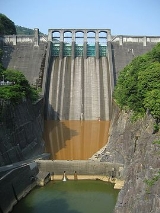
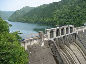
The is a dam
on the border of Mitake
and Yaotsu
in Gifu Prefecture
, Japan
. It was built on the upper reaches of the Kiso River
system. It is a gravity dam that is 98.2 m (322 ft) tall. It was built after World War II
as part of a large, nationwide dam building project.
further upstream, the area is part of the Hida-Kisogawa Quasi-National Park
.

Dam
A dam is a barrier that impounds water or underground streams. Dams generally serve the primary purpose of retaining water, while other structures such as floodgates or levees are used to manage or prevent water flow into specific land regions. Hydropower and pumped-storage hydroelectricity are...
on the border of Mitake
Mitake, Gifu
is a town located in Kani District, Gifu Prefecture, Japan.As of July 2011, the town had an estimated population of 18,709. The total area is 56.61 km².-Rail:*Nagoya Railroad**Hiromi Line - Gōdo, Mitakeguchi, Mitake-External links:*...
and Yaotsu
Yaotsu, Gifu
is a town located in Kamo District, Gifu, Japan.As of July 2011, the town has an estimated population of 11,855. The total area is 128.81 km².Yaotsu was the birthplace of Chiune Sugihara and is home to the Chiune Sugihara Memorial.-External links:...
in Gifu Prefecture
Gifu Prefecture
is a prefecture located in the Chūbu region of central Japan. Its capital is the city of Gifu.Located in the center of Japan, it has long played an important part as the crossroads of Japan, connecting the east to the west through such routes as the Nakasendō...
, Japan
Japan
Japan is an island nation in East Asia. Located in the Pacific Ocean, it lies to the east of the Sea of Japan, China, North Korea, South Korea and Russia, stretching from the Sea of Okhotsk in the north to the East China Sea and Taiwan in the south...
. It was built on the upper reaches of the Kiso River
Kiso River
The is a river in Japan roughly 193 km long, flowing through the prefectures of Nagano, Gifu, Aichi, and Mie before emptying into Ise Bay a short distance away from the city of Nagoya. It is the main river of the Kiso Three Rivers and forms a major part of the Nōbi Plain...
system. It is a gravity dam that is 98.2 m (322 ft) tall. It was built after World War II
World War II
World War II, or the Second World War , was a global conflict lasting from 1939 to 1945, involving most of the world's nations—including all of the great powers—eventually forming two opposing military alliances: the Allies and the Axis...
as part of a large, nationwide dam building project.
Surrounding area
Sosui Gorge (蘇水峡 Sosui-kyō) was formed by the completion of the dam. Along with Ena GorgeEna Gorge
is a river valley located at the mid reaches of the Kiso River, which runs through the cities of Ena and Nakatsugawa in Gifu Prefecture, Japan.Ena Gorge was so named by Shiga Shigetaka, a geographer of that time who praised the harmony of the mysteriously shaped rocks, which appeared to be...
further upstream, the area is part of the Hida-Kisogawa Quasi-National Park
Hida-Kisogawa Quasi-National Park
The is a quasi-national park in Japan. The park covers the Hida River from Gero to Minokamo in Gifu Prefecture; it also covers the middle reaches of the Kiso River from Mizunami, Gifu Prefecture, to Inuyama, Aichi Prefecture. It was designated a quasi-national park in March 1964.-Area...
.


