
Maryland Route 145
Encyclopedia
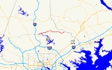
Maryland Route 145 is a state highway
in the U.S. state of Maryland
. The state highway runs 10.34 miles (16.6 km) from MD 45
in Hunt Valley
east to MD 165
near Baldwin
. MD 145 connects the north-central and eastern portions of Baltimore County
via Jacksonville. The first section of the highway was built from Loch Raven Reservoir
to Jacksonville in the early 1910s. The remainder of MD 145 east to Baldwin was completed in the mid-1920s. The state highway was extended west to Hunt Valley in the early 1980s in a maintenance swap. When MD 145's bridge over Loch Raven Reservoir was replaced in 2000, the old bridge from 1922 was preserved.
. The state highway veers east again and intersects the rail trail
at an acute angle; just east of the crosswalk is a parking lot serving the trail. MD 145 enters the parkland surrounding Loch Raven Reservoir and crosses the upper reach of the reservoir on a steel box arch bridge. Immediately to the south is the grey arch through truss bridge that previously carried MD 145 across the reservoir. The state highway follows Greene Branch out of the valley of Gunpowder Falls. MD 145 leaves the Loch Raven Reservoir park reservation east of Phoenix Road and passes through a golf course. The state highway intersects MD 146
(Jarrettsville Pike) at an oblique intersection in the community of Jacksonville, which is also known as Phoenix. MD 145 continues east as Sweet Air Road, which passes through the hamlet of the same name around Manor Road. The state highway reaches its eastern terminus at MD 165 (Baldwin Mill Road) north of Baldwin. Sweet Air Road continues east as a county highway to a cul-de-sac
near Little Gunpowder Falls.
Bridges have crossed Gunpowder Falls at the site of MD 145's modern crossing since at least the 1770s. The road gets its name from the paper mill constructed at the crossing in 1850. Early in the 20th century, the waterway was crossed by the Paper Mill Covered Bridge. In 1922, the Baltimore City Department of Transportation, which maintains most of the roads within the reservoir park area, replaced the covered bridge with an arch through truss bridge in preparation for the filling of the expanded Loch Raven Reservoir. Construction began on the present Paper Mill Road Bridge in 1998; the new bridge opened in 2000. The city gave the old bridge to Baltimore County; the county refurbished the bridge in 2007 to preserve it as a historical landmark and prepare it for recreational use.
.
{|class=wikitable
!Location
!Mile
!Destinations
!Notes
|-
|Hunt Valley
|0.00
|
|Western terminus
|-
|Jacksonville
|5.57
|
|
|-
|Baldwin
|10.34
|
|Eastern terminus
State highway
State highway, state road or state route can refer to one of three related concepts, two of them related to a state or provincial government in a country that is divided into states or provinces :#A...
in the U.S. state of Maryland
Maryland
Maryland is a U.S. state located in the Mid Atlantic region of the United States, bordering Virginia, West Virginia, and the District of Columbia to its south and west; Pennsylvania to its north; and Delaware to its east...
. The state highway runs 10.34 miles (16.6 km) from MD 45
Maryland Route 45
Maryland Route 45 is a state highway in the U.S. state of Maryland. Known for most of its length as York Road, the state highway runs from U.S. Route 1 in Baltimore north to the Pennsylvania state line in Maryland Line, where the highway continues as SR 3001...
in Hunt Valley
Hunt Valley, Maryland
Hunt Valley is an affluent unincorporated community in Baltimore County, Maryland, United States. It lies just north of the city of Baltimore, along Highway 145 off Interstate 83. Loch Raven Reservoir...
east to MD 165
Maryland Route 165
Maryland Route 165 is a state highway in the U.S. state of Maryland. The state highway runs from Baldwin north to the Pennsylvania state line in Cardiff, where the highway continues as Pennsylvania Route 74 . MD 165 passes through western and northern Harford County, where it connects the...
near Baldwin
Baldwin, Maryland
Baldwin is an unincorporated community in Baltimore County, Maryland, United States. The United States Postal Service has assigned Baldwin the ZIP Code 21013. Until 1958, this community was served by the Maryland and Pennsylvania Railroad at milepost 18.4. Hidden Valley Farm was listed on the...
. MD 145 connects the north-central and eastern portions of Baltimore County
Baltimore County, Maryland
Baltimore County is a county located in the northern part of the US state of Maryland. In 2010, its population was 805,029. It is part of the Baltimore-Washington Metropolitan Area. Its county seat is Towson. The name of the county was derived from the barony of the Proprietor of the Maryland...
via Jacksonville. The first section of the highway was built from Loch Raven Reservoir
Loch Raven Reservoir
The Loch Raven Reservoir is a reservoir that provides drinking water for the City of Baltimore and most of Baltimore County, Maryland. Originally built in 1881 as a dam and water tunnel to channel water to Lake Montebello and Lake Clifton, the new dam was constructed in 1914 in efforts to increase...
to Jacksonville in the early 1910s. The remainder of MD 145 east to Baldwin was completed in the mid-1920s. The state highway was extended west to Hunt Valley in the early 1980s in a maintenance swap. When MD 145's bridge over Loch Raven Reservoir was replaced in 2000, the old bridge from 1922 was preserved.
Route description
MD 145 begins at an intersection with MD 45 (York Road) in Hunt Valley. The state highway heads east as two-lane Ashland Road, which crosses over Western Run. At Ashland Road, MD 145 continues northeast on Paper Mill Road; Ashland Road leads to the southern terminus of the Northern Central Railroad TrailNorthern Central Railroad Trail
The Torrey C. Brown Trail, formerly known as the Northern Central Railroad Trail is a rail trail that runs along an abandoned railroad corridor where the Northern Central Railway used to run. The trails extends from Cockeysville, Maryland to the boundary with Pennsylvania. At the Pennsylvania...
. The state highway veers east again and intersects the rail trail
Rail trail
A rail trail is the conversion of a disused railway easement into a multi-use path, typically for walking, cycling and sometimes horse riding. The characteristics of former tracks—flat, long, frequently running through historical areas—are appealing for various development. The term sometimes also...
at an acute angle; just east of the crosswalk is a parking lot serving the trail. MD 145 enters the parkland surrounding Loch Raven Reservoir and crosses the upper reach of the reservoir on a steel box arch bridge. Immediately to the south is the grey arch through truss bridge that previously carried MD 145 across the reservoir. The state highway follows Greene Branch out of the valley of Gunpowder Falls. MD 145 leaves the Loch Raven Reservoir park reservation east of Phoenix Road and passes through a golf course. The state highway intersects MD 146
Maryland Route 146
Maryland Route 146 is a state highway in the U.S. state of Maryland. The state highway runs from MD 45 in Towson north to MD 23 near Jarrettsville. MD 146 connects Towson with Loch Raven Reservoir, an impoundment of Gunpowder Falls. The state highway also serves the northern Baltimore County...
(Jarrettsville Pike) at an oblique intersection in the community of Jacksonville, which is also known as Phoenix. MD 145 continues east as Sweet Air Road, which passes through the hamlet of the same name around Manor Road. The state highway reaches its eastern terminus at MD 165 (Baldwin Mill Road) north of Baldwin. Sweet Air Road continues east as a county highway to a cul-de-sac
Cul-de-sac
A cul-de-sac is a word of French origin referring to a dead end, close, no through road or court meaning dead-end street with only one inlet/outlet...
near Little Gunpowder Falls.
History
Paper Mill Road from Gunpowder Falls to Jacksonville was constructed as a 9 feet (2.7 m) wide concrete road by 1915. This road was widened and resurfaced in macadam from the eastern edge of the Loch Raven Reservoir park reservation at Phoenix Road to Old York Road west of Jacksonville around 1933. Sweet Air Road was constructed from Jacksonville to Manor Road at Sweet Air by 1923. The paved road was extended east from Sweet Air to Bradshaw, including what is now MD 165 south of MD 145, between 1924 and 1927. MD 145 was extended west to MD 45 around 1983 when Paper Mill Road and Ashland Road through the reservoir area were transferred from city to state maintenance.Bridges have crossed Gunpowder Falls at the site of MD 145's modern crossing since at least the 1770s. The road gets its name from the paper mill constructed at the crossing in 1850. Early in the 20th century, the waterway was crossed by the Paper Mill Covered Bridge. In 1922, the Baltimore City Department of Transportation, which maintains most of the roads within the reservoir park area, replaced the covered bridge with an arch through truss bridge in preparation for the filling of the expanded Loch Raven Reservoir. Construction began on the present Paper Mill Road Bridge in 1998; the new bridge opened in 2000. The city gave the old bridge to Baltimore County; the county refurbished the bridge in 2007 to preserve it as a historical landmark and prepare it for recreational use.
Junction list
The entire route is in Baltimore CountyBaltimore County, Maryland
Baltimore County is a county located in the northern part of the US state of Maryland. In 2010, its population was 805,029. It is part of the Baltimore-Washington Metropolitan Area. Its county seat is Towson. The name of the county was derived from the barony of the Proprietor of the Maryland...
.
{|class=wikitable
!Location
!Mile
!Destinations
!Notes
|-
|Hunt Valley
Hunt Valley, Maryland
Hunt Valley is an affluent unincorporated community in Baltimore County, Maryland, United States. It lies just north of the city of Baltimore, along Highway 145 off Interstate 83. Loch Raven Reservoir...
|0.00
|
|Western terminus
|-
|Jacksonville
|5.57
|
|
|-
|Baldwin
Baldwin, Maryland
Baldwin is an unincorporated community in Baltimore County, Maryland, United States. The United States Postal Service has assigned Baldwin the ZIP Code 21013. Until 1958, this community was served by the Maryland and Pennsylvania Railroad at milepost 18.4. Hidden Valley Farm was listed on the...
|10.34
|
|Eastern terminus