Maryland Route 382
Encyclopedia
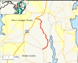
Maryland Route 382 (Croom Road) is a state highway in Prince George's County
. It begins after a small bridge crosses County Line Creek (which links Covington Road in Charles County
to Croom Road / Route 382), and it heads north until its northern terminus at US 301
in Marlton
.
Route 382 is also a component of the Maryland Scenic Byways system as Byway #13, Star-Spangled Banner.
It is a two-lane highway that carries a north–south designation and it runs for a total length of 15.34 miles (24.7 km).
.
Notable points of interest on or near Route 382 include:
Prince George's County, Maryland
Prince George's County is a county located in the U.S. state of Maryland, immediately north, east, and south of Washington, DC. As of 2010, it has a population of 863,420 and is the wealthiest African-American majority county in the nation....
. It begins after a small bridge crosses County Line Creek (which links Covington Road in Charles County
Charles County, Maryland
Charles County is a county in the south central portion of the U.S. state of Maryland.As of 2010, the population was 146,551. Its county seat is La Plata. This county was named for Charles Calvert , third Baron Baltimore....
to Croom Road / Route 382), and it heads north until its northern terminus at US 301
U.S. Route 301 in Maryland
U.S. Route 301 in Maryland is a major highway that runs from Delaware to the Governor Harry W. Nice Memorial Bridge into Virginia. It passes through three of Maryland's four main regions: the Eastern Shore, the Baltimore-Washington Metropolitan Area, and Southern Maryland...
in Marlton
Marlton, Maryland
Marlton is an unincorporated area and census-designated place in Prince George's County, Maryland, United States. The population was 7,798 at the 2000 census. The Marlton housing development, at first briefly called "Marlboro Country", grew up along U.S. Route 301 in the 1970s, and is part of the...
.
Route 382 is also a component of the Maryland Scenic Byways system as Byway #13, Star-Spangled Banner.
It is a two-lane highway that carries a north–south designation and it runs for a total length of 15.34 miles (24.7 km).
Route description
Maryland Route 382 begins along Croom Road along County Line Creek as a continuation of Covington Road in Charles County. It travels north through heavily wooded southern Prince George's County and intersects MD 381 in Baden. It continues from there, curving eastward and passing through a mix of woods and farmland, serving mostly homes along its path. After crossing Black Swamp Creek it turns to the north, serving sparse residences and passing by Patuxent River Park, accessible via Mount Calvert Road. The route also passes by the historic Saint Thomas Church, accessible by Saint Thomas Church Road. The route curves to the west and ends at U.S. Route 301U.S. Route 301 in Maryland
U.S. Route 301 in Maryland is a major highway that runs from Delaware to the Governor Harry W. Nice Memorial Bridge into Virginia. It passes through three of Maryland's four main regions: the Eastern Shore, the Baltimore-Washington Metropolitan Area, and Southern Maryland...
.
Notable points of interest on or near Route 382 include:
- Mt. Calvert Historical & Archaeological Park
- Rosaryville State Park (via US 301U.S. Route 301 in MarylandU.S. Route 301 in Maryland is a major highway that runs from Delaware to the Governor Harry W. Nice Memorial Bridge into Virginia. It passes through three of Maryland's four main regions: the Eastern Shore, the Baltimore-Washington Metropolitan Area, and Southern Maryland...
) - Merkle Wildlife Sanctuary
Junction list
| County | Location | Mile | Intersection | Notes |
|---|---|---|---|---|
| Prince George's County Prince George's County, Maryland Prince George's County is a county located in the U.S. state of Maryland, immediately north, east, and south of Washington, DC. As of 2010, it has a population of 863,420 and is the wealthiest African-American majority county in the nation.... |
0.00 | Charles County Charles County, Maryland Charles County is a county in the south central portion of the U.S. state of Maryland.As of 2010, the population was 146,551. Its county seat is La Plata. This county was named for Charles Calvert , third Baron Baltimore.... Line |
Southern terminus | |
| 0.65 |  MD 381 MD 381Maryland Route 381 Maryland Route 381 is a state highway in Charles County and Prince George's County. It begins by branching off of MD 231 in eastern Charles County and heads north for before crossing into the south-eastern tip of Prince George's County... - Brandywine Road |
|||
| 3.05 | Baden Westwood Road | |||
| 8.30 | Candy Hill Road | |||
| 11.27 | St. Thomas Church Road | Access to Merkle Wildlife Sanctuary | ||
| 12.83 | Mt. Calvert Road | Access to Mt. Calvert Historical & Archaeological Park | ||
| Marlton Marlton, Maryland Marlton is an unincorporated area and census-designated place in Prince George's County, Maryland, United States. The population was 7,798 at the 2000 census. The Marlton housing development, at first briefly called "Marlboro Country", grew up along U.S. Route 301 in the 1970s, and is part of the... |
15.34 | Northern terminus |

