
Massachusetts Route 99
Encyclopedia
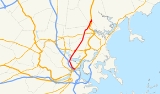
Route description
Route 99 begins at the intersection of New Rutherford Avenue and Chelsea Street, over the northbound tunnel of U.S. Route 1U.S. Route 1 in Massachusetts
In the U.S. state of Massachusetts, U.S. Route 1 is a major north–south state highway through Boston. The portion of US 1 south of Boston is also known as the Boston-Providence Turnpike, and portions north of the city are known as the Northeast Expressway and the Newburyport Turnpike.-Route...
created during the Big Dig
Big Dig
The Central Artery/Tunnel Project , known unofficially as the Big Dig and as the Big Dug since completion, was a megaproject in Boston that rerouted the Central Artery , the chief highway through the heart of the city, into a 3.5-mile tunnel...
. It continues along New Rutherford Avenue, passing onramps to Route 1 and Bunker Hill Community College
Bunker Hill Community College
Bunker Hill Community College is a two-year community college located in Charlestown, Boston, Massachusetts. It is an urban campus with over 10,000 students. Six in ten students are people of color and more than half of all students are women. There are 650 international students attending BHCC;...
before entering Sullivan Square, where Route 38 begins next to the MBTA station
Sullivan Square (MBTA station)
Sullivan Square is a station on the MBTA rapid transit Orange Line, and a major bus transfer point. It was also a major transfer point on the old Charlestown Elevated, with two streetcar loops for free transfers, later converted for trackless trolleys and buses.The first Sullivan Square station...
. It then turns northeastward onto Alford Street, crossing the Malden Bridge over the Mystic River
Mystic River
The Mystic River is a river in Massachusetts, in the United States. Its name derives from the Wampanoag word "muhs-uhtuq", which translates to "big river." In an Algonquian language, "Missi-Tuk" means "a great river whose waters are driven by waves", alluding to the natural tidal nature of the...
. After passing through a small strip of Boston on the east banks of the river, the route enters Everett
Everett, Massachusetts
Everett is a city in Middlesex County, Massachusetts, United States, near Boston. The population was 41,667 at the 2010 census.Everett is the last city in the United States with a bicameral legislature, which is composed of a seven-member Board of Aldermen and an 18-member Common Council...
and becomes Broadway.
Broadway crosses through Sweetser Circle, the intersection with Route 16
Massachusetts Route 16
Route 16 is an east–west state highway in Massachusetts. It begins in the west at an intersection with Route 12 and Route 193 in Webster, just north of the Connecticut state border...
and the Revere Beach Parkway
Revere Beach Parkway
Revere Beach Parkway is a historic parkway in the northern suburbs of Boston, Massachusetts. It begins at the Fellsway in Medford, where the road leading to the west is the Mystic Valley Parkway, proceeds east, ending at the junction of Revere Beach Boulevard and Winthrop Parkway in Revere. In...
. The route continues northeastward into the city of Malden
Malden, Massachusetts
Malden is a suburban city in Middlesex County, Massachusetts, United States. The population was 59,450 at the 2010 census. In 2009 Malden was ranked as the "Best Place to Raise Your Kids" in Massachusetts by Bloomberg Businessweek Magazine.-History:...
, where it intersects Route 60. The route continues on through a short (0.25 mile (0.402335 km)) corner of Melrose
Melrose, Massachusetts
-Government:Robert J. Dolan is the mayor. Melrose is represented in the Massachusetts House of Representatives by Paul Brodeur . Katherine Clark is the state senator for wards 1 through 5 and Thomas McGee is the state senator for wards 6 and 7. Melrose is part of the seventh Congressional...
before entering Saugus
Saugus, Massachusetts
Saugus is a town in Essex County, Massachusetts, United States, in the Greater Boston area. The population was 26,628 at the 2010 census.-History:Saugus was first settled in 1629. Saugus is an Indian name believed to mean "great" or "extended"...
. Once in Saugus the route terminates at ramps leading back to Route 1.
History
The Charlestown BridgeCharlestown Bridge
The Charlestown Bridge is the easternmost bridge on the Charles River in Boston, Massachusetts. The bridge formerly carried the southernmost stretch of Massachusetts Route 99, which now ends at Chelsea Street in Charlestown. It connects to Joe Tecce Way to the south and to Rutherford Avenue to the...
from Boston's North End into Charlestown used to be that starting point of the route; however, the latest GIS data from the Massachusetts Department of Transportation indicates that it is no longer the starting point for Route 99. This probably became the case upon completion of the Big Dig's moving of Route 1.
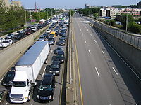
Sweetser Circle has been the site of numerous major accidents, including a gas tanker rollover early on December 5, 2007 that resulted in 9400 U.S.gal spilling, igniting and destroying 21 vehicles and two large multi-family homes.
Prior to the designation as Route 99, the entire route was part of US-1
U.S. Route 1 in Massachusetts
In the U.S. state of Massachusetts, U.S. Route 1 is a major north–south state highway through Boston. The portion of US 1 south of Boston is also known as the Boston-Providence Turnpike, and portions north of the city are known as the Northeast Expressway and the Newburyport Turnpike.-Route...
before the construction of the Northeast Expressway.
Junction list
| County | Location | Mile | Roads intersected | Notes |
|---|---|---|---|---|
| Suffolk Suffolk County, Massachusetts Suffolk County has no land border with Plymouth County to its southeast, but the two counties share a water boundary in the middle of Massachusetts Bay.-National protected areas:*Boston African American National Historic Site... |
Boston Boston Boston is the capital of and largest city in Massachusetts, and is one of the oldest cities in the United States. The largest city in New England, Boston is regarded as the unofficial "Capital of New England" for its economic and cultural impact on the entire New England region. The city proper had... |
0.00 | Chelsea Street | Southern end of Route 99. |
| 0.2 |  U.S. Route 1 U.S. Route 1U.S. Route 1 in Massachusetts In the U.S. state of Massachusetts, U.S. Route 1 is a major north–south state highway through Boston. The portion of US 1 south of Boston is also known as the Boston-Providence Turnpike, and portions north of the city are known as the Northeast Expressway and the Newburyport Turnpike.-Route... |
Ramp ending from southbound and to northbound Route 1. | ||
| 1.1 |  Route 38 Route 38 |
Southern end of Route 38 at Sullivan Square. | ||
| Middlesex Middlesex County, Massachusetts -National protected areas:* Assabet River National Wildlife Refuge* Great Meadows National Wildlife Refuge* Longfellow National Historic Site* Lowell National Historical Park* Minute Man National Historical Park* Oxbow National Wildlife Refuge... |
Everett Everett, Massachusetts Everett is a city in Middlesex County, Massachusetts, United States, near Boston. The population was 41,667 at the 2010 census.Everett is the last city in the United States with a bicameral legislature, which is composed of a seven-member Board of Aldermen and an 18-member Common Council... |
2.5 |  Route 16 Route 16Massachusetts Route 16 Route 16 is an east–west state highway in Massachusetts. It begins in the west at an intersection with Route 12 and Route 193 in Webster, just north of the Connecticut state border... |
Sweetser Circle: Access to Route 16 / Revere Beach Parkway Revere Beach Parkway Revere Beach Parkway is a historic parkway in the northern suburbs of Boston, Massachusetts. It begins at the Fellsway in Medford, where the road leading to the west is the Mystic Valley Parkway, proceeds east, ending at the junction of Revere Beach Boulevard and Winthrop Parkway in Revere. In... |
| Malden Malden, Massachusetts Malden is a suburban city in Middlesex County, Massachusetts, United States. The population was 59,450 at the 2010 census. In 2009 Malden was ranked as the "Best Place to Raise Your Kids" in Massachusetts by Bloomberg Businessweek Magazine.-History:... |
4.8 |  Route 60 Route 60 |
||
| Essex Essex County, Massachusetts -National protected areas:* Parker River National Wildlife Refuge* Salem Maritime National Historic Site* Saugus Iron Works National Historic Site* Thacher Island National Wildlife Refuge-Demographics:... |
Saugus Saugus, Massachusetts Saugus is a town in Essex County, Massachusetts, United States, in the Greater Boston area. The population was 26,628 at the 2010 census.-History:Saugus was first settled in 1629. Saugus is an Indian name believed to mean "great" or "extended"... |
6.40 | U.S. Route 1 U.S. Route 1 in Massachusetts In the U.S. state of Massachusetts, U.S. Route 1 is a major north–south state highway through Boston. The portion of US 1 south of Boston is also known as the Boston-Providence Turnpike, and portions north of the city are known as the Northeast Expressway and the Newburyport Turnpike.-Route... |
Northern end of Route 99 at Route 1. |