Matilija Creek
Encyclopedia
Matilija Creek is a major stream in Ventura County in the U.S. state
of California
. It joins with North Fork Matilija Creek to form the Ventura River
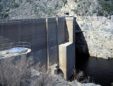
. Many tributaries feed the mostly free flowing, 17.3 miles (27.8 km) creek, which is largely contained in the Matilija Wilderness. It then forms the reservoir behind Matilija Dam, which was built to store 5000 acre.ft of water. The reservoir has filled with sediment, rendering it useless, and there are proposals to remove the dam, which has already been reduced in height twice.
. The meaning of the Chumash name is unknown.
, the creek flows east and south through a narrow, flat-floored valley. It then turns east and receives the Middle Fork, which flows generally south and west, on the right, then flows east paralleling Forest Road 5N24 before it empties into Matilija Lake (really a reservoir), now mostly a mudflat, on a broad, flat alluvial fan
. After exiting the approximately 200 feet (61 m) high dam, the creek turns north and meets the North Fork Matilija Creek; from there on it is called the Ventura River.
The smaller North Fork Matilija Creek flows west and south from its headwaters near Rose Valley, which is the source of Sespe Creek. The creek runs west, paralleling Forest Route 6N31, and receives a small tributary with a roughly fan-shaped drainage basin from the left. It then turns north and cascades through a narrow gorge, then receives a tributary from the left. It then begins to parallel California State Route 33
as it nears the town of Wheeler Springs. It arcs to the east and joins Matilija Creek shortly downstream.
Fed by some perennial springs, despite its location in arid terrain, the creek flows year round, and tends to reach enormous flows in the rainy season.
 The name of the Matilija poppy
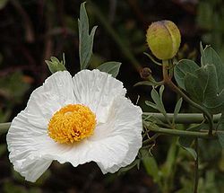
(Romneya coulteri|Romneya) is taken from the Matilija creek canyon. The Matilija Dam was constructed in 1947 on lower Matilija Creek for the purpose of supplying water storage and flood control, blocking access of anadromous Steelhead trout (Oncorhynchus mykiss) to over ten miles of upstream spawning areas. Historically 5,000 steelhead trout used the upper Matilija basin. The Robles Diversion Dam on the Ventura River downstream posed a barrier to trout migration until a $6 million fish ladder was constructed in 2006. Recent genetic analysis of the steelhead in Matilija Creek (both above and below Matilija Dam) has shown them to be of native and not hatchery stocks.
U.S. state
A U.S. state is any one of the 50 federated states of the United States of America that share sovereignty with the federal government. Because of this shared sovereignty, an American is a citizen both of the federal entity and of his or her state of domicile. Four states use the official title of...
of California
California
California is a state located on the West Coast of the United States. It is by far the most populous U.S. state, and the third-largest by land area...
. It joins with North Fork Matilija Creek to form the Ventura River
Ventura River
The Ventura River is a river in Ventura County, California. The river forms at the confluence of Matilija Creek and North Fork Matilija Creek, upstream from the Pacific Ocean...
. Many tributaries feed the mostly free flowing, 17.3 miles (27.8 km) creek, which is largely contained in the Matilija Wilderness. It then forms the reservoir behind Matilija Dam, which was built to store 5000 acre.ft of water. The reservoir has filled with sediment, rendering it useless, and there are proposals to remove the dam, which has already been reduced in height twice.
History
Matilija was one of the Chumash rancherias under the jurisdiction of Mission San BuenaventuraMission San Buenaventura
Mission San Buenaventura was founded on Easter Sunday, March 31, 1782 in Las Californias, part of the Spanish Viceroyalty of New Spain. Named for a Franciscan theologian, Saint Bonaventure, it was the last of the missions founded by Father Serra...
. The meaning of the Chumash name is unknown.
Geography
From its headwaters south of Sespe CreekSespe Creek
Sespe Creek is a stream, some long, in Ventura County, California, in the United States. The creek starts at Potrero Seco in the Sierra Madre Mountains, and is formed by more than thirty tributary streams before it empties into the Santa Clara River in Fillmore. Thirty-one miles of Sespe Creek are...
, the creek flows east and south through a narrow, flat-floored valley. It then turns east and receives the Middle Fork, which flows generally south and west, on the right, then flows east paralleling Forest Road 5N24 before it empties into Matilija Lake (really a reservoir), now mostly a mudflat, on a broad, flat alluvial fan
Alluvial fan
An alluvial fan is a fan-shaped deposit formed where a fast flowing stream flattens, slows, and spreads typically at the exit of a canyon onto a flatter plain. A convergence of neighboring alluvial fans into a single apron of deposits against a slope is called a bajada, or compound alluvial...
. After exiting the approximately 200 feet (61 m) high dam, the creek turns north and meets the North Fork Matilija Creek; from there on it is called the Ventura River.
The smaller North Fork Matilija Creek flows west and south from its headwaters near Rose Valley, which is the source of Sespe Creek. The creek runs west, paralleling Forest Route 6N31, and receives a small tributary with a roughly fan-shaped drainage basin from the left. It then turns north and cascades through a narrow gorge, then receives a tributary from the left. It then begins to parallel California State Route 33
California State Route 33
State Route 33 is a north–south state highway in the U.S. state of California. SR 33 replaced part of U.S. Route 399 in 1964 during the "great renumbering" of routes. In the unincorporated sections of Kern County it is known as the West Side Highway...
as it nears the town of Wheeler Springs. It arcs to the east and joins Matilija Creek shortly downstream.
Fed by some perennial springs, despite its location in arid terrain, the creek flows year round, and tends to reach enormous flows in the rainy season.
Ecology

Matilija poppy
Romneya is a genus of flowering plants belonging to the poppy family . There are two species in genus Romneya, which was named for Irish astronomer John Thomas Romney Robinson. They are known commonly as Matilija poppies or tree poppies and are native to southern California and northern...
(Romneya coulteri|Romneya) is taken from the Matilija creek canyon. The Matilija Dam was constructed in 1947 on lower Matilija Creek for the purpose of supplying water storage and flood control, blocking access of anadromous Steelhead trout (Oncorhynchus mykiss) to over ten miles of upstream spawning areas. Historically 5,000 steelhead trout used the upper Matilija basin. The Robles Diversion Dam on the Ventura River downstream posed a barrier to trout migration until a $6 million fish ladder was constructed in 2006. Recent genetic analysis of the steelhead in Matilija Creek (both above and below Matilija Dam) has shown them to be of native and not hatchery stocks.
See also
- Rindge DamRindge DamThe -tall Rindge Dam on Malibu Creek is located in Malibu Creek State Park, about three miles from the coast of Malibu, California. It is situated just northeast of Malibu Canyon Road, from which it is only partially visible...
, which Malibu CreekMalibu CreekMalibu Creek is a year-round stream in western Los Angeles County, California. It drains the southern Simi Hills and the westernmost San Fernando Valley, flows south through the Santa Monica Mountains, and enters Santa Monica Bay east of Malibu. The Malibu Creek watershed drains and its tributary...
filled with sediment like Matilija Dam - Riparian zone restorationRiparian zone restorationRiparian zone restoration is the ecological restoration of riparian zone habitats of streams, rivers, springs, lakes, floodplains, and other hydrologic ecologies.Riparian zones have been degraded throughout much of the world...

